
Maryland Route 657
Encyclopedia
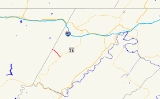
Maryland Route 657 is a state highway
in the U.S. state
of Maryland
. The state highway runs 1.82 miles (2.9 km) from MD 36
in Lonaconing
north to the Garrett County
line, where it continues north as Avilton–Lonaconing Road. MD 657 was designated in 1939 and reconstructed in 2010.
. The state highway heads northwest as Douglas Avenue, a two-lane road with a speed limit of 15 miles per hour (24.1 km/h) maintained by the town of Lonaconing. After passing Old Beechwood Road, MD 657 leaves the town of Lonaconing, becoming state-maintained with a new name, Skids Hill Road. The roadway narrows to 15 feet (4.6 m) and the speed limit increases to 25 miles per hour (40.2 km/h) as the state highway climbs toward Big Savage Mountain
high above Koontz Creek. At the Garrett County line, MD 657 ends and continues north as Avilton–Lonaconing Road toward the top of the ridge.
in 1934. MD 657 was designated when that county highway was brought into the state highway system in 1939. In March 2010, a 50 feet (15.2 m) section of the state highway was damaged by a torrent of water released from an abandoned mine following several days of rainfall, requiring an emergency repair project that reduced the roadway's width at the site from 15 feet (4.6 m) to 13.5 feet (4.1 m). MD 657 had already been scheduled to be reconstructed from Old Beechwood Road to the Garrett County line with retaining walls and a wider roadway, a project that began in April 2010 and was expected to be completed in the autumn.
in Allegany County
.
{| class=wikitable
!Mile
!Destinations
!Notes
|-
|0.00
|
|Southern terminus
|-
|1.82
|Avilton–Lonaconing Road north
|Northern terminus; Garrett County
line
State highway
State highway, state road or state route can refer to one of three related concepts, two of them related to a state or provincial government in a country that is divided into states or provinces :#A...
in the U.S. state
U.S. state
A U.S. state is any one of the 50 federated states of the United States of America that share sovereignty with the federal government. Because of this shared sovereignty, an American is a citizen both of the federal entity and of his or her state of domicile. Four states use the official title of...
of Maryland
Maryland
Maryland is a U.S. state located in the Mid Atlantic region of the United States, bordering Virginia, West Virginia, and the District of Columbia to its south and west; Pennsylvania to its north; and Delaware to its east...
. The state highway runs 1.82 miles (2.9 km) from MD 36
Maryland Route 36
Maryland Route 36 is a state highway located in Allegany County, Maryland, United States. MD 36's southern terminus is at the WV 46 bridge in Westernport and its northern terminus at U.S. Route 40 Alternate near Cumberland...
in Lonaconing
Lonaconing, Maryland
Lonaconing is a town in Allegany County, Maryland, United States located along the Georges Creek Valley. It is part of the Cumberland, MD-WV Metropolitan Statistical Area. The population was 1,205 at the 2000 census.- History :...
north to the Garrett County
Garrett County, Maryland
Garrett County is the westernmost county of the U.S. state of Maryland. Created from Allegany County, Maryland in 1872 it was the last Maryland county to be formed. It was named for John Work Garrett , railroad executive, industrialist, and financier. Garrett served as president of the Baltimore...
line, where it continues north as Avilton–Lonaconing Road. MD 657 was designated in 1939 and reconstructed in 2010.
Route description
MD 657 begins at MD 36 (Main Street) within the Lonaconing Historic DistrictLonaconing Historic District
The Lonaconing Historic District is a national historic district in Lonaconing, Allegany County, Maryland. It comprises 278 buildings and structures consisting of a variety of 19th and early-20th century commercial, industrial, and residential buildings...
. The state highway heads northwest as Douglas Avenue, a two-lane road with a speed limit of 15 miles per hour (24.1 km/h) maintained by the town of Lonaconing. After passing Old Beechwood Road, MD 657 leaves the town of Lonaconing, becoming state-maintained with a new name, Skids Hill Road. The roadway narrows to 15 feet (4.6 m) and the speed limit increases to 25 miles per hour (40.2 km/h) as the state highway climbs toward Big Savage Mountain
Savage Mountain
The two Big Savage Mountain summits are part of Savage Mountain.The two Big Savage Mountain summits are part of Savage Mountain....
high above Koontz Creek. At the Garrett County line, MD 657 ends and continues north as Avilton–Lonaconing Road toward the top of the ridge.
History
Skids Hill Road was improved as a county highway by the Maryland State Roads CommissionMaryland State Highway Administration
The Maryland State Highway Administration is the state agency responsible for maintaining Maryland numbered highways outside of Baltimore City...
in 1934. MD 657 was designated when that county highway was brought into the state highway system in 1939. In March 2010, a 50 feet (15.2 m) section of the state highway was damaged by a torrent of water released from an abandoned mine following several days of rainfall, requiring an emergency repair project that reduced the roadway's width at the site from 15 feet (4.6 m) to 13.5 feet (4.1 m). MD 657 had already been scheduled to be reconstructed from Old Beechwood Road to the Garrett County line with retaining walls and a wider roadway, a project that began in April 2010 and was expected to be completed in the autumn.
Junction list
The entire route is in LonaconingLonaconing, Maryland
Lonaconing is a town in Allegany County, Maryland, United States located along the Georges Creek Valley. It is part of the Cumberland, MD-WV Metropolitan Statistical Area. The population was 1,205 at the 2000 census.- History :...
in Allegany County
Allegany County, Maryland
Allegany County is a county located in the northwestern part of the US state of Maryland. It is part of the Cumberland, MD-WV Metropolitan Statistical Area. As of 2010, the population was 75,087. Its county seat is Cumberland...
.
{| class=wikitable
!Mile
!Destinations
!Notes
|-
|0.00
|
|Southern terminus
|-
|1.82
|Avilton–Lonaconing Road north
|Northern terminus; Garrett County
Garrett County, Maryland
Garrett County is the westernmost county of the U.S. state of Maryland. Created from Allegany County, Maryland in 1872 it was the last Maryland county to be formed. It was named for John Work Garrett , railroad executive, industrialist, and financier. Garrett served as president of the Baltimore...
line