
Maryland Route 646
Encyclopedia
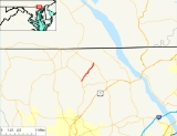
Maryland Route 646 is a state highway
in the U.S. state
of Maryland
. Known as Prospect Road, the state highway runs 3.31 miles (5.3 km) from MD 543
near Ady north to MD 136
in Prospect. MD 646 was constructed as a section of MD 543 in the early 1930s. That section of MD 543 and road originally marked as MD 646 swapped numbers by 1946.
. MD 646 heads northeast through farmland. After crossing Broad Creek
, the state highway passes through the Mill Green Historic District
, where it intersects Mill Green Road. MD 646 crosses Broad Creek again and continues to its northern terminus at MD 136 (Whiteford Road) in the hamlet of Prospect. Prospect Road continues north as a county highway toward the Pennsylvania
state line.
, which was constructed around 1938. By 1946, MD 646 and MD 543 had swapped to their present routes north from Emory Church toward Mill Green and Pylesville, respectively. MD 646 was extended north to MD 136 in 1950.
.
{|class=wikitable
!Location
!Mile
!Destinations
!Notes
|-
|Ady
|0.00
|
|Cherry Hill Road west
|Southern terminus
|-
|Prospect
|3.31
|
|Northern terminus
State highway
State highway, state road or state route can refer to one of three related concepts, two of them related to a state or provincial government in a country that is divided into states or provinces :#A...
in the U.S. state
U.S. state
A U.S. state is any one of the 50 federated states of the United States of America that share sovereignty with the federal government. Because of this shared sovereignty, an American is a citizen both of the federal entity and of his or her state of domicile. Four states use the official title of...
of Maryland
Maryland
Maryland is a U.S. state located in the Mid Atlantic region of the United States, bordering Virginia, West Virginia, and the District of Columbia to its south and west; Pennsylvania to its north; and Delaware to its east...
. Known as Prospect Road, the state highway runs 3.31 miles (5.3 km) from MD 543
Maryland Route 543
Maryland Route 543 is a state highway in the U.S. state of Maryland. The state highway runs from U.S. Route 40 in Riverside north to MD 165 in Pylesville. MD 543 is a north–south highway through central Harford County that connects the communities of Creswell, Fountain Green, Hickory and...
near Ady north to MD 136
Maryland Route 136
Maryland Route 136 is a state highway in the U.S. state of Maryland. The state highway runs from MD 7 near Abingdon north to MD 23 in Norrisville. MD 136 is an L-shaped route that connects the communities of Creswell, Churchville, Dublin, and Whiteford in eastern Harford County with each other...
in Prospect. MD 646 was constructed as a section of MD 543 in the early 1930s. That section of MD 543 and road originally marked as MD 646 swapped numbers by 1946.
Route description
MD 646 begins at an intersection with MD 543 (Ady Road) in the hamlet of Emory Church near Ady. Cherry Hill Road heads west from the other side of MD 543 as a county highway toward Rocks State ParkRocks State Park
The Rocks State Park, originally known as Deer Creek State Park, is a state park located in Deer Creek Valley near Pylesville in Harford County, Maryland. The park, located near the junction of Maryland Routes 24 and 165 is near the Mason-Dixon Line, and about a one-hour drive from Baltimore...
. MD 646 heads northeast through farmland. After crossing Broad Creek
Broad Creek (Susquehanna River)
Broad Creek is a tributary of the lower Susquehanna River located in Harford County, Maryland.Broad Creek originates on the west side of Constitution Road, just south of the Pennsylvania state line. It runs generally south-southeast for to the Conowingo Reservoir along the Susquehanna...
, the state highway passes through the Mill Green Historic District
Mill Green Historic District
The Mill Green Historic District is a National Register of Historic Places listed community located in Street, Maryland. The district consists of a small cluster of privately owned historic homes and buildings including a historic mill. The district is located at the junction of Mill Green Road and...
, where it intersects Mill Green Road. MD 646 crosses Broad Creek again and continues to its northern terminus at MD 136 (Whiteford Road) in the hamlet of Prospect. Prospect Road continues north as a county highway toward the Pennsylvania
Pennsylvania
The Commonwealth of Pennsylvania is a U.S. state that is located in the Northeastern and Mid-Atlantic regions of the United States. The state borders Delaware and Maryland to the south, West Virginia to the southwest, Ohio to the west, New York and Ontario, Canada, to the north, and New Jersey to...
state line.
History
The portion of modern MD 646 from MD 543 at Emory Church to just north of Mill Green was constructed in 1933 as the northern end of MD 543. MD 646 was originally assigned to the section of MD 543 between Emory Church and PylesvillePylesville, Maryland
Pylesville is an unincorporated community in Harford County, in the Baltimore metro area of the state of Maryland in the United States. Governed at the county level, the area has a population of around 2000. Until 1958, this community was served by the Maryland and Pennsylvania Railroad at milepost...
, which was constructed around 1938. By 1946, MD 646 and MD 543 had swapped to their present routes north from Emory Church toward Mill Green and Pylesville, respectively. MD 646 was extended north to MD 136 in 1950.
Junction list
The entire route is in Harford CountyHarford County, Maryland
Harford County is a county in the U.S. state of Maryland. In 2010, its population was 244,826. Its county seat is Bel Air. Harford County forms part of the Baltimore-Washington Metropolitan Area.-History:...
.
{|class=wikitable
!Location
!Mile
!Destinations
!Notes
|-
|Ady
|0.00
|
|Cherry Hill Road west
|Southern terminus
|-
|Prospect
|3.31
|
|Northern terminus