
Maryland Route 60
Encyclopedia
Maryland Route 60 is a state highway
in the U.S. state
of Maryland
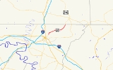
. Known for most of its length as Leitersburg Pike, the state highway runs 7.27 miles (11.7 km) from the intersection of Potomac Street and Northern Avenue in Hagerstown
east to the Pennsylvania
state line near Leitersburg
, where the highway continues as Pennsylvania Route 316
(PA 316). MD 60 connects Hagerstown with Leitersburg and Waynesboro, Pennsylvania
. MD 60 was paved over the course of an old turnpike from Hagerstown toward Waynesboro in the mid 1920s. The state highway was reconstructed in the mid 1950s, including the highway's bypass of Leitersburg.
. Eastern Boulevard heads east toward the historic home Rockland Farm. Potomac Street heads south toward downtown Hagerstown, passing through the Oak Hill
and Potomac-Broadway
historic districts and by the Zion Reformed United Church of Christ
and the Hagerstown Armory
. MD 60 heads north as Potomac Avenue, leaving the city limits of Hagerstown before reaching a junction with Marsh Pike, which heads north toward the suburbs of Paramount and Long Meadow
. MD 60 continues northeast as Leitersburg Pike through farmland, passing the Dorsey-Palmer House
before crossing Marsh Run.
MD 60 crosses Antietam Creek
and passes the Lantz-Zeigler House
before reaching Leitersburg. The state highway intersects MD 62
(Little Antietam Road) on the west side of the unincorporated village before curving to the north to bypass the village while Leiter Street, the old alignment of MD 60, continues straight to pass through the Leitersburg Historic District
. North of the village center, MD 60 intersects Leiters Mill Road and the western end of MD 418
(Ringgold Pike), then curves north and receives the other end of Leiter Street. The state highway starts to parallel Antietam Creek as it reaches its eastern terminus at the Pennsylvania state line. The highway continues north as PA 316 (Wayne Highway) toward Waynesboro.
.
{|class=wikitable
!Location
!Mile
!Destinations
!Notes
|-
|Hagerstown
|0.00
|Northern Avenue west / Eastern Boulevard south / Potomac Avenue south
|Western terminus
|-
|rowspan=2|Leitersburg
|4.83
|
|
|-
|5.35
|
|
|-
|
|7.27
|
|Eastern terminus; Pennsylvania
state line
State highway
State highway, state road or state route can refer to one of three related concepts, two of them related to a state or provincial government in a country that is divided into states or provinces :#A...
in the U.S. state
U.S. state
A U.S. state is any one of the 50 federated states of the United States of America that share sovereignty with the federal government. Because of this shared sovereignty, an American is a citizen both of the federal entity and of his or her state of domicile. Four states use the official title of...
of Maryland
Maryland
Maryland is a U.S. state located in the Mid Atlantic region of the United States, bordering Virginia, West Virginia, and the District of Columbia to its south and west; Pennsylvania to its north; and Delaware to its east...
. Known for most of its length as Leitersburg Pike, the state highway runs 7.27 miles (11.7 km) from the intersection of Potomac Street and Northern Avenue in Hagerstown
Hagerstown, Maryland
Hagerstown is a city in northwestern Maryland, United States. It is the county seat of Washington County, and, by many definitions, the largest city in a region known as Western Maryland. The population of Hagerstown city proper at the 2010 census was 39,662, and the population of the...
east to the Pennsylvania
Pennsylvania
The Commonwealth of Pennsylvania is a U.S. state that is located in the Northeastern and Mid-Atlantic regions of the United States. The state borders Delaware and Maryland to the south, West Virginia to the southwest, Ohio to the west, New York and Ontario, Canada, to the north, and New Jersey to...
state line near Leitersburg
Leitersburg, Maryland
Leitersburg is a census-designated place in Washington County, Maryland, United States. The population was 523 at the 2000 census.-Geography:Leitersburg is located at ....
, where the highway continues as Pennsylvania Route 316
Pennsylvania Route 316
Pennsylvania Route 316 is an long state highway located in Franklin county in Pennsylvania. The southern terminus is at the Maryland state line near Waynesboro. The northern terminus is at US 11 in Chambersburg.-Route description:...
(PA 316). MD 60 connects Hagerstown with Leitersburg and Waynesboro, Pennsylvania
Waynesboro, Pennsylvania
Waynesboro is a borough in Franklin County, Pennsylvania, located northwest of Baltimore, Maryland, 67 miles southwest of Harrisburg, Pennsylvania, and north of the Mason-Dixon Line. The population within the borough limits was 9,614 at the 2000 census. When combined with the surrounding...
. MD 60 was paved over the course of an old turnpike from Hagerstown toward Waynesboro in the mid 1920s. The state highway was reconstructed in the mid 1950s, including the highway's bypass of Leitersburg.
Route description
MD 60 begins at an intersection with Northern Avenue, Eastern Boulevard, and Potomac Avenue in the city of Hagerstown. Northern Avenue heads west past St. Maria Goretti High SchoolSt. Maria Goretti High School
Saint Maria Goretti High School is a private, Roman Catholic day school located in Hagerstown, MD. It is located in the Roman Catholic Archdiocese of Baltimore, within the tri-state areas of the Eastern Panhandle of West Virginia, Western Maryland, and Southern Pennsylvania.- Who and where :Saint...
. Eastern Boulevard heads east toward the historic home Rockland Farm. Potomac Street heads south toward downtown Hagerstown, passing through the Oak Hill
Oak Hill Historic District (Hagerstown, Maryland)
Oak Hill Historic District is a national historic district at Hagerstown, Washington County, Maryland, United States. The district consists of a residential neighborhood of approximately in northern Hagerstown. It is characterized generally by large scale houses built in the first third of the...
and Potomac-Broadway
Potomac-Broadway Historic District
Potomac-Broadway Historic District is a national historic district at Hagerstown, Washington County, Maryland, United States. The district is located in the north downtown area and consists largely of a late 19th and early 20th century residential area with most buildings dating from 1870-1930...
historic districts and by the Zion Reformed United Church of Christ
Zion Reformed United Church of Christ
Zion Reformed United Church of Christ, originally The German Reformed Church was founded in 1770 in Hagerstown, Maryland. The church, at 201 North Potomac Street, was the first within the town limits. It is the oldest church building in Washington County, Maryland that has been in continuous use as...
and the Hagerstown Armory
Hagerstown Armory
Hagerstown Armory is a historic armory located at 328 N. Potomac Street in Hagerstown, Washington County, Maryland, United States. It is a two-story Flemish bond brick structure with full basement emulating a Medieval fortification, built in 1926. The front facade features a central block offset by...
. MD 60 heads north as Potomac Avenue, leaving the city limits of Hagerstown before reaching a junction with Marsh Pike, which heads north toward the suburbs of Paramount and Long Meadow
Paramount-Long Meadow, Maryland
Paramount-Long Meadow is a census-designated place in Washington County, Maryland, United States. The population was 2,722 at the 2000 census.-Geography:Paramount-Long Meadow is located at ....
. MD 60 continues northeast as Leitersburg Pike through farmland, passing the Dorsey-Palmer House
Dorsey-Palmer House
The Dorsey-Palmer House is a historic home located near Hagerstown, Washington County, Maryland, United States. It was built about 1800, and is a two-story, five-bay fieldstone dwelling with a two-story, four-bay rear wing...
before crossing Marsh Run.
MD 60 crosses Antietam Creek
Antietam Creek
Antietam Creek is a tributary of the Potomac River located in south central Pennsylvania and western Maryland in the United States, a region known as the Hagerstown Valley...
and passes the Lantz-Zeigler House
Lantz-Zeigler House
The Lantz-Zeigler House is a historic home located at Hagerstown, Washington County, Maryland, United States. The house consists of a two-story stone main section built in 1800 with a two-story perpendicular ell to the rear...
before reaching Leitersburg. The state highway intersects MD 62
Maryland Route 62
Maryland Route 62 is a state highway in the U.S. state of Maryland. Known for most of its length as Little Antietam Road, the state highway runs from MD 804 in Chewsville north to MD 60 in Leitersburg in northeastern Washington County...
(Little Antietam Road) on the west side of the unincorporated village before curving to the north to bypass the village while Leiter Street, the old alignment of MD 60, continues straight to pass through the Leitersburg Historic District
Leitersburg Historic District
Leitersburg Historic District is a national historic district at Leitersburg, Washington County, Maryland, United States. The district is centered on this early-19th century village. The village square retains three original early 19th century brick buildings, a tavern, general store, and...
. North of the village center, MD 60 intersects Leiters Mill Road and the western end of MD 418
Maryland Route 418
Maryland Route 418 is a state highway in the U.S. state of Maryland. Known as Ringgold Pike, the state highway runs from Maryland Route 60 in Leitersburg east to the Pennsylvania state line near Ringgold, where the highway continues as State Route 2007 in Franklin County...
(Ringgold Pike), then curves north and receives the other end of Leiter Street. The state highway starts to parallel Antietam Creek as it reaches its eastern terminus at the Pennsylvania state line. The highway continues north as PA 316 (Wayne Highway) toward Waynesboro.
History
The predecessor highway of MD 60 was the Hagerstown and Waynesboro Turnpike, which ran from Hagerstown to the Pennsylvania state line via Leitersburg. MD 60 was paved as a modern highway from Hagerstown to Leitersburg in 1923 and from Leitersburg to the state line by 1927. The first relocation of MD 60 occurred in 1941 when the highway's bridge over Antietam Creek was replaced. The state highway was reconstructed from its western terminus to the western end of the Antietam Creek relocation in 1952. The segment of MD 60 between Antietam Creek and Leitersburg was rebuilt in 1953 and 1954. The bypass of Leitersburg was constructed and the highway north to the state line was reconstructed between 1954 and 1956.Junction list
The entire route is in Washington CountyWashington County, Maryland
Washington County is a county located in the western part of the U.S. state of Maryland, bordering southern Pennsylvania to the north, northern Virginia to the south, and the Eastern Panhandle of West Virginia to the south and west. As of the 2010 Census, its population is 147,430...
.
{|class=wikitable
!Location
!Mile
!Destinations
!Notes
|-
|Hagerstown
Hagerstown, Maryland
Hagerstown is a city in northwestern Maryland, United States. It is the county seat of Washington County, and, by many definitions, the largest city in a region known as Western Maryland. The population of Hagerstown city proper at the 2010 census was 39,662, and the population of the...
|0.00
|Northern Avenue west / Eastern Boulevard south / Potomac Avenue south
|Western terminus
|-
|rowspan=2|Leitersburg
Leitersburg, Maryland
Leitersburg is a census-designated place in Washington County, Maryland, United States. The population was 523 at the 2000 census.-Geography:Leitersburg is located at ....
|4.83
|
|
|-
|5.35
|
|
|-
|
|7.27
|
|Eastern terminus; Pennsylvania
Pennsylvania
The Commonwealth of Pennsylvania is a U.S. state that is located in the Northeastern and Mid-Atlantic regions of the United States. The state borders Delaware and Maryland to the south, West Virginia to the southwest, Ohio to the west, New York and Ontario, Canada, to the north, and New Jersey to...
state line