
Maryland Route 42
Encyclopedia
Maryland Route 42 is a state highway
in the U.S. state
of Maryland
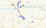
. Known as Friendsville Road, the state highway runs 15.06 miles (24.2 km) from U.S. Route 219
(US 219) near McHenry
north to the Pennsylvania
state line in Asher Glade, where the highway continues as State Route 2013 in Fayette County
toward Pennsylvania Route 281
(PA 281) in Markleysburg
. MD 42 provides the most direct route between Friendsville
and southern Garrett County
. The state highway was constructed as a modern highway from Friendsville to north of Accident
in the early 1920s. The remainder of the highway through Asher Glade was completed in the early 1930s. The southern terminus was shifted from Accident to McHenry in 1960.
MD 742, heads north into the center of Friendsville while MD 42 bypasses the town center to the south and west.
After crossing the Youghiogheny River
, MD 42 turns northwest and meets Interstate 68
(I-68) at a diamond interchange
. The entrance ramp from MD 42 to westbound I-68 forms the fourth leg of the intersection with the other end of MD 742, Maple Street, which receives the exit ramp from westbound I-68. MD 42 heads west up a creek valley to an intersection with Blooming Rose Road, then turns north and crosses Buffalo Run. Shortly after crossing Laurel Run and Glade Run, the state highway passes through the unincorporated community of Asher Glade before the highway reaches its northern terminus at the Pennsylvania state line. The road continues north as SR 2013 (Friendsville Road) toward Markleysburg, where the highway meets PA 281.
MD 42 was transferred from its eastern terminus near Accident to a southern terminus near McHenry, following First Street north to Maple Street within Friendsville, in 1960. The state highway originally followed Hoyes Road east from the crossroads in Hoyes to US 219 north of the present terminus. MD 42 was shifted to its present terminus south of Hoyes around 1972. The state highway was relocated in Friendsville to connect with its interchange with I-68 in 1975; First Street and Maple Street through Friendsville were designated MD 742.
.
{| class=wikitable
!Location
!Mile
!Destinations
!Notes
|-
|McHenry
|0.00
|
|Southern terminus
|-
|rowspan=3|Friendsville
|7.27
|First Avenue north
|Unsigned MD 742
|-
|7.67
|, Morgantown
|I-68 Exit 4
|-
|7.83
|Maple Street east
|Unsigned MD 742
|-
|Asher Glade
|15.06
|PA SR 2013 north to – Markleysburg, PA
|Northern terminus; Pennsylvania
state line
State highway
State highway, state road or state route can refer to one of three related concepts, two of them related to a state or provincial government in a country that is divided into states or provinces :#A...
in the U.S. state
U.S. state
A U.S. state is any one of the 50 federated states of the United States of America that share sovereignty with the federal government. Because of this shared sovereignty, an American is a citizen both of the federal entity and of his or her state of domicile. Four states use the official title of...
of Maryland
Maryland
Maryland is a U.S. state located in the Mid Atlantic region of the United States, bordering Virginia, West Virginia, and the District of Columbia to its south and west; Pennsylvania to its north; and Delaware to its east...
. Known as Friendsville Road, the state highway runs 15.06 miles (24.2 km) from U.S. Route 219
U.S. Route 219 in Maryland
U.S. Route 219 is a part of the U.S. Highway System that runs from Rich Creek, Virginia to West Seneca, New York. In the U.S. state of Maryland, the federal highway runs from the West Virginia state line near Red House to the Pennsylvania state line near Grantsville...
(US 219) near McHenry
McHenry, Maryland
McHenry is a small community located in Garrett County, Maryland on the northern most shore of Deep Creek Lake.Located on the outskirts of McHenry is the Garrett County Airport, Wisp Ski Resort, and Golf Club at Wisp....
north to the Pennsylvania
Pennsylvania
The Commonwealth of Pennsylvania is a U.S. state that is located in the Northeastern and Mid-Atlantic regions of the United States. The state borders Delaware and Maryland to the south, West Virginia to the southwest, Ohio to the west, New York and Ontario, Canada, to the north, and New Jersey to...
state line in Asher Glade, where the highway continues as State Route 2013 in Fayette County
Fayette County, Pennsylvania
Fayette County is a county located in the U.S. state of Pennsylvania. As of the2010 census, the population was 136,606. The county is part of the Pittsburgh Metropolitan Statistical Area....
toward Pennsylvania Route 281
Pennsylvania Route 281
Pennsylvania Route 281 is an long state highway located in Fayette and Somerset counties in Pennsylvania. The southern terminus is the West Virginia state line near Markleysburg...
(PA 281) in Markleysburg
Markleysburg, Pennsylvania
Markleysburg is a borough in Fayette County, Pennsylvania, United States. The population was 282 at the 2000 census. The town is served by the Uniontown Area School District.-Geography:Markleysburg is located at ....
. MD 42 provides the most direct route between Friendsville
Friendsville, Maryland
Friendsville is a town in Garrett County, Maryland, United States. The population was 539 at the 2000 census.-Geography:Friendsville is located at ....
and southern Garrett County
Garrett County, Maryland
Garrett County is the westernmost county of the U.S. state of Maryland. Created from Allegany County, Maryland in 1872 it was the last Maryland county to be formed. It was named for John Work Garrett , railroad executive, industrialist, and financier. Garrett served as president of the Baltimore...
. The state highway was constructed as a modern highway from Friendsville to north of Accident
Accident, Maryland
Accident is a town in Garrett County, Maryland, United States. The population was 353 at the 2000 census. The town is home to Northern Garrett High School...
in the early 1920s. The remainder of the highway through Asher Glade was completed in the early 1930s. The southern terminus was shifted from Accident to McHenry in 1960.
Route description
MD 42 begins at a tangent intersection with US 219 (Garrett Highway) at the northern edge of McHenry near Deep Creek Lake. The state highway heads north as a two-lane road. After meeting Hoyes Sang Run Road in the hamlet of Hoyes, MD 42 curves west then north again through farmland. The state highway features a pull-off for trucks to check their brakes before starting a descent with grades of up to 8%. The uphill direction has a climbing lane for part of the ascent. At the bottom of the hill, MD 42 enters the town of Friendsville and turns west. First Avenue, which is unsignedUnsigned highway
An unsigned highway is a highway that has been assigned a route number, but does not bear conventional road markings that would normally be used to identify the route with that number...
MD 742, heads north into the center of Friendsville while MD 42 bypasses the town center to the south and west.
After crossing the Youghiogheny River
Youghiogheny River
The Youghiogheny River , or the Yough for short, is a tributary of the Monongahela River in the U.S. states of West Virginia, Maryland, and Pennsylvania...
, MD 42 turns northwest and meets Interstate 68
Interstate 68
Interstate 68 is a Interstate highway in the U.S. states of West Virginia and Maryland, connecting in Morgantown to in Hancock. is also Corridor E of the Appalachian Development Highway System. From 1965 until the freeway's construction was completed in 1991, it was designated as...
(I-68) at a diamond interchange
Diamond interchange
A diamond interchange is a common type of road junction, used where a freeway crosses a minor road. The freeway itself is grade-separated from the minor road, one crossing the other over a bridge...
. The entrance ramp from MD 42 to westbound I-68 forms the fourth leg of the intersection with the other end of MD 742, Maple Street, which receives the exit ramp from westbound I-68. MD 42 heads west up a creek valley to an intersection with Blooming Rose Road, then turns north and crosses Buffalo Run. Shortly after crossing Laurel Run and Glade Run, the state highway passes through the unincorporated community of Asher Glade before the highway reaches its northern terminus at the Pennsylvania state line. The road continues north as SR 2013 (Friendsville Road) toward Markleysburg, where the highway meets PA 281.
History
MD 42 originally connected Friendsville with US 219 north of Accident via Bear Creek Road instead of the current connection near McHenry. The state highway was paved for about 3 miles (4.8 km) east of Friendsville in 1921. The highway was complete to present day US 219 at the hamlet of Kaese Mill north of Accident in 1923. The first section of MD 42 from Friendsville to the Pennsylvania state line was completed in 1928 from the west side of the Youghiogheny River to Blooming Rose Road. The modern Maple Street bridge over the Youghiogheny River was built in 1932. Construction of MD 42 from Blooming Rose Road to the state line began in 1932 and was completed in 1935.MD 42 was transferred from its eastern terminus near Accident to a southern terminus near McHenry, following First Street north to Maple Street within Friendsville, in 1960. The state highway originally followed Hoyes Road east from the crossroads in Hoyes to US 219 north of the present terminus. MD 42 was shifted to its present terminus south of Hoyes around 1972. The state highway was relocated in Friendsville to connect with its interchange with I-68 in 1975; First Street and Maple Street through Friendsville were designated MD 742.
Junction list
The entire route is in Garrett CountyGarrett County, Maryland
Garrett County is the westernmost county of the U.S. state of Maryland. Created from Allegany County, Maryland in 1872 it was the last Maryland county to be formed. It was named for John Work Garrett , railroad executive, industrialist, and financier. Garrett served as president of the Baltimore...
.
{| class=wikitable
!Location
!Mile
!Destinations
!Notes
|-
|McHenry
McHenry, Maryland
McHenry is a small community located in Garrett County, Maryland on the northern most shore of Deep Creek Lake.Located on the outskirts of McHenry is the Garrett County Airport, Wisp Ski Resort, and Golf Club at Wisp....
|0.00
|
|Southern terminus
|-
|rowspan=3|Friendsville
Friendsville, Maryland
Friendsville is a town in Garrett County, Maryland, United States. The population was 539 at the 2000 census.-Geography:Friendsville is located at ....
|7.27
|First Avenue north
|Unsigned MD 742
|-
|7.67
|, Morgantown
Morgantown, West Virginia
Morgantown is a city in Monongalia County, West Virginia. It is the county seat of Monongalia County. Placed along the banks of the Monongahela River, Morgantown is the largest city in North-Central West Virginia, and the base of the Morgantown metropolitan area...
|I-68 Exit 4
|-
|7.83
|Maple Street east
|Unsigned MD 742
|-
|Asher Glade
|15.06
|PA SR 2013 north to – Markleysburg, PA
Markleysburg, Pennsylvania
Markleysburg is a borough in Fayette County, Pennsylvania, United States. The population was 282 at the 2000 census. The town is served by the Uniontown Area School District.-Geography:Markleysburg is located at ....
|Northern terminus; Pennsylvania
Pennsylvania
The Commonwealth of Pennsylvania is a U.S. state that is located in the Northeastern and Mid-Atlantic regions of the United States. The state borders Delaware and Maryland to the south, West Virginia to the southwest, Ohio to the west, New York and Ontario, Canada, to the north, and New Jersey to...
state line