
Maryland Route 396
Encyclopedia
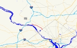
Maryland Route 396 is the route designation of the extension of Massachusetts Avenue from Washington, D.C.
, into Bethesda, Maryland
. The Maryland section of Massachusetts Avenue runs for just over two miles (3 km), from Westmoreland Circle
at the District line to Goldsboro Road (Maryland Route 614
).
.
Washington, D.C.
Washington, D.C., formally the District of Columbia and commonly referred to as Washington, "the District", or simply D.C., is the capital of the United States. On July 16, 1790, the United States Congress approved the creation of a permanent national capital as permitted by the U.S. Constitution....
, into Bethesda, Maryland
Bethesda, Maryland
Bethesda is a census designated place in southern Montgomery County, Maryland, United States, just northwest of Washington, D.C. It takes its name from a local church, the Bethesda Meeting House , which in turn took its name from Jerusalem's Pool of Bethesda...
. The Maryland section of Massachusetts Avenue runs for just over two miles (3 km), from Westmoreland Circle
Westmoreland Circle
Westmoreland Circle is a traffic circle straddling the border between the U.S. state of Maryland and Washington, D.C. The circle lies at the intersection of Western Avenue, Butterworth Place, Massachusetts Avenue, Dalecarlia Parkway, Wetherill Road, and Dalecarlia Drive.There are only two buildings...
at the District line to Goldsboro Road (Maryland Route 614
Maryland Route 614
Maryland Route 614 is a state highway in the U.S. state of Maryland. Known as Goldsboro Road, the state highway runs from MacArthur Boulevard in Glen Echo north to MD 191 in Bethesda.-Route description:...
).
Route description
Beginning at Westmoreland Circle atop the Washington D.C. line, Massachusetts Avenue and MD 396 travel northwest on four lanes of divided roadway through a residential area, fronted directly by homes and several patches of woodland. The Capital Crescent Trail passes over the street via overpass north of Little Falls Parkway. At Sangamore Road, the route condenses to two lanes with shoulders, still fronted by homes and carrying sidewalks. The route ends in the north at MD 614 (Goldsboro Road).Junction list
The entire route is in Montgomery CountyMontgomery County, Maryland
Montgomery County is a county in the U.S. state of Maryland, situated just to the north of Washington, D.C., and southwest of the city of Baltimore. It is one of the most affluent counties in the United States, and has the highest percentage of residents over 25 years of age who hold post-graduate...
.
| Location | Mile |
Intersection | Notes |
|---|---|---|---|
| Bethesda Bethesda, Maryland Bethesda is a census designated place in southern Montgomery County, Maryland, United States, just northwest of Washington, D.C. It takes its name from a local church, the Bethesda Meeting House , which in turn took its name from Jerusalem's Pool of Bethesda... |
0.00 | Western terminus | |
| 2.21 | Westmoreland Circle Westmoreland Circle Westmoreland Circle is a traffic circle straddling the border between the U.S. state of Maryland and Washington, D.C. The circle lies at the intersection of Western Avenue, Butterworth Place, Massachusetts Avenue, Dalecarlia Parkway, Wetherill Road, and Dalecarlia Drive.There are only two buildings... |
Washington, D.C. Washington, D.C. Washington, D.C., formally the District of Columbia and commonly referred to as Washington, "the District", or simply D.C., is the capital of the United States. On July 16, 1790, the United States Congress approved the creation of a permanent national capital as permitted by the U.S. Constitution.... border, eastern terminus |