
Maryland Route 367
Encyclopedia
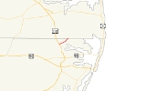
Maryland Route 367 is a state highway
in the U.S. state
of Maryland
. Known as Bishopville Road, the state highway runs 2.6 miles (4.2 km) from the county-maintained portion of Bishopville Road in Bishop
east to the Delaware
state line in Bishopville
. MD 367 connects U.S. Route 113
(US 113) with Bishopville and other small communities on the St. Martin Neck in northern Worcester County
. The state highway was constructed between Bishop and Bishopville in two steps in the mid 1920s and early 1930s, respectively. The segment within Bishopville was constructed as part of an extended MD 368 in the mid 1910s. The portion from Bishopville to the Delaware state line was constructed in the mid 1930s as MD 568. All three state highways were reassigned to their present lengths in 1950.
in the hamlet of Bishop. Bishopville Road continues west of the railroad track as a county highway. MD 367 intersects US 113 (Worcester Highway), then continues east as a two-lane road toward Bishopville. After crossing Buntings Branch of the St. Martin River, the state highway enters Bishopville and intersects MD 368 (St. Martins Neck Road) and MD 568 (Hatchery Road), both of which are unsigned
. MD 367 reaches its eastern terminus at the Delaware state line, where the highway continues northeast as Hudson Road in Sussex County
.
{| class=wikitable
!Location
!Mile
!Destinations
!Notes
|-
|rowspan=2|Bishop
|0.00
|Bishopville Road west
|Western terminus
|-
|0.09
|, Selbyville, DE
|
|-
|rowspan=3|Bishopville
|1.84
|
|MD 368 is unsigned
|-
|2.13
| – Selbyville, DE
|MD 568 is unsigned
|-
|2.60
|Hudson Road north – Fenwick Island, DE
|Eastern terminus; Delaware
state line
State highway
State highway, state road or state route can refer to one of three related concepts, two of them related to a state or provincial government in a country that is divided into states or provinces :#A...
in the U.S. state
U.S. state
A U.S. state is any one of the 50 federated states of the United States of America that share sovereignty with the federal government. Because of this shared sovereignty, an American is a citizen both of the federal entity and of his or her state of domicile. Four states use the official title of...
of Maryland
Maryland
Maryland is a U.S. state located in the Mid Atlantic region of the United States, bordering Virginia, West Virginia, and the District of Columbia to its south and west; Pennsylvania to its north; and Delaware to its east...
. Known as Bishopville Road, the state highway runs 2.6 miles (4.2 km) from the county-maintained portion of Bishopville Road in Bishop
Bishop, Maryland
Bishop is an unincorporated community in Worcester County, Maryland, United States. Bishop is located at the intersection of U.S. Route 113 and Maryland Route 367 just south of the Delaware state line.-References:...
east to the Delaware
Delaware
Delaware is a U.S. state located on the Atlantic Coast in the Mid-Atlantic region of the United States. It is bordered to the south and west by Maryland, and to the north by Pennsylvania...
state line in Bishopville
Bishopville, Maryland
Bishopville is a small unincorporated community 10 miles north of Berlin in Worcester County, Maryland, located at . The community is just south of the Delaware state line....
. MD 367 connects U.S. Route 113
U.S. Route 113
U.S. Route 113 is a spur of US 13 in the U.S. states of Maryland and Delaware. The U.S. Highway runs from US 13 in Pocomoke City, Maryland north to Delaware Route 1 in Milford, Delaware...
(US 113) with Bishopville and other small communities on the St. Martin Neck in northern Worcester County
Worcester County, Maryland
-2010:Whereas according to the 2010 U.S. Census Bureau:*82.0% White*13.6% Black*0.3% Native American*1.1% Asian*0.0% Native Hawaiian or Pacific Islander*1.7% Two or more races*1.3% Other races*3.2% Hispanic or Latino -2000:...
. The state highway was constructed between Bishop and Bishopville in two steps in the mid 1920s and early 1930s, respectively. The segment within Bishopville was constructed as part of an extended MD 368 in the mid 1910s. The portion from Bishopville to the Delaware state line was constructed in the mid 1930s as MD 568. All three state highways were reassigned to their present lengths in 1950.
Route description
MD 367 begins on the east side of the Snow Hill Line of the Maryland and Delaware RailroadMaryland and Delaware Railroad
The Maryland and Delaware Railroad Company is a Class III short-line railroad, formed in 1977 to operate several branch lines of the former Penn Central Railroad in both Maryland and Delaware. These branches were omitted from the system plan for Conrail in 1976 and would have been discontinued...
in the hamlet of Bishop. Bishopville Road continues west of the railroad track as a county highway. MD 367 intersects US 113 (Worcester Highway), then continues east as a two-lane road toward Bishopville. After crossing Buntings Branch of the St. Martin River, the state highway enters Bishopville and intersects MD 368 (St. Martins Neck Road) and MD 568 (Hatchery Road), both of which are unsigned
Unsigned highway
An unsigned highway is a highway that has been assigned a route number, but does not bear conventional road markings that would normally be used to identify the route with that number...
. MD 367 reaches its eastern terminus at the Delaware state line, where the highway continues northeast as Hudson Road in Sussex County
Sussex County, Delaware
Sussex County is a county located in the southern part of the U.S. state of Delaware. As of 2010 the population was 197,145, an increase of 25.9% over the previous decade. The county seat is Georgetown. The Seaford Micropolitan Statistical Area includes all of Sussex County.Sussex County is...
.
History
The first part of MD 367 to be paved was between present day MD 368 and MD 568 in Bishopville. That segment, plus the present lengths of MD 368 and MD 568, were paved as a state-aid road between 1912 and 1915 and later designated MD 368. The next segment of modern MD 367 was between the western terminus and just west of Buntings Branch, which was completed by 1923. The connection over Buntings Branch to MD 368 was finished by 1933. The remainder of Bishopville Road to the Delaware state line was completed in 1934 and designated MD 568. MD 367 was extended east from MD 368 to the Delaware state line in 1950 when MD 368 was rolled back to its present length and MD 568 was reassigned to Hatchery Road.Junction list
The entire route is in Worcester County.{| class=wikitable
!Location
!Mile
!Destinations
!Notes
|-
|rowspan=2|Bishop
Bishop, Maryland
Bishop is an unincorporated community in Worcester County, Maryland, United States. Bishop is located at the intersection of U.S. Route 113 and Maryland Route 367 just south of the Delaware state line.-References:...
|0.00
|Bishopville Road west
|Western terminus
|-
|0.09
|, Selbyville, DE
Selbyville, Delaware
As of the census of 2000, there were 1,645 people, 615 households, and 439 families residing in the town. The population density was 1,176.9 people per square mile . There were 664 housing units at an average density of 475.1 per square mile...
|
|-
|rowspan=3|Bishopville
Bishopville, Maryland
Bishopville is a small unincorporated community 10 miles north of Berlin in Worcester County, Maryland, located at . The community is just south of the Delaware state line....
|1.84
|
|MD 368 is unsigned
|-
|2.13
| – Selbyville, DE
Selbyville, Delaware
As of the census of 2000, there were 1,645 people, 615 households, and 439 families residing in the town. The population density was 1,176.9 people per square mile . There were 664 housing units at an average density of 475.1 per square mile...
|MD 568 is unsigned
|-
|2.60
|Hudson Road north – Fenwick Island, DE
Fenwick Island, Delaware
As of the census of 2000, there were 342 people, 178 households, and 126 families residing in the town. The population density was 994.5 people per square mile . There were 666 housing units at an average density of 1,936.7 per square mile . The racial makeup of the town was 99.42% White, and 0.58%...
|Eastern terminus; Delaware
Delaware
Delaware is a U.S. state located on the Atlantic Coast in the Mid-Atlantic region of the United States. It is bordered to the south and west by Maryland, and to the north by Pennsylvania...
state line