
Maryland Route 229
Encyclopedia
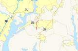
Maryland Route 229 is a state highway
in the U.S. state
of Maryland
. Known as Bensville Road, the state highway runs 5.25 miles (8.4 km) from MD 227
near Pomfret
north to MD 228
near Bennsville
. MD 229 passes through the community of Bennsville in northern Charles County
. The state highway was originally constructed as part of MD 228 in the late 1920s. When MD 228 was extended west to Accokeek
in the mid 1990s, MD 229 was assigned to Bensville Road.
with St. Charles
. The state highway veers northeast, paralleling Mattawoman Creek
to its northern terminus at MD 228 (Berry Road) just south of the Prince George's County
line.
and MD 3
(now MD 257
) in Wayside in southern Charles County. Morgantown Road was constructed as a modern highway by 1921. MD 229 served as the connection to a Potomac River
ferry that operated between Morgantown and Colonial Beach, Virginia
from 1933 to at least the early 1940s. Morgantown Road was removed from the state highway system in 1956.
Bensville Road was originally part of MD 228. The highway was constructed as a 15 feet (4.6 m) gravel road from Pomfret to Bennsville in 1925 and 1926. The remainder of Bensville Road was built in 1927. The MD 228 designation was removed from Bensville Road after that highway was extended to Accokeek in southwestern Prince George's County
in 1995. MD 229 was assigned to Bensville Road by 1997.
.
{| class=wikitable
!Location
!Mile
!Destinations
!Notes
|-
|Pomfret
|0.00
|
|Southern terminus
|-
|rowspan=2|Bennsville
|1.60
|Billingsley Road – St. Charles
, Bryans Road
|
|-
|5.25
|
|Northern terminus
State highway
State highway, state road or state route can refer to one of three related concepts, two of them related to a state or provincial government in a country that is divided into states or provinces :#A...
in the U.S. state
U.S. state
A U.S. state is any one of the 50 federated states of the United States of America that share sovereignty with the federal government. Because of this shared sovereignty, an American is a citizen both of the federal entity and of his or her state of domicile. Four states use the official title of...
of Maryland
Maryland
Maryland is a U.S. state located in the Mid Atlantic region of the United States, bordering Virginia, West Virginia, and the District of Columbia to its south and west; Pennsylvania to its north; and Delaware to its east...
. Known as Bensville Road, the state highway runs 5.25 miles (8.4 km) from MD 227
Maryland Route 227
Maryland Route 227 is a state highway in the U.S. state of Maryland. The state highway runs from Marshall Hall east to U.S. Route 301 in White Plains. MD 227 connects the communities of Bryans Road, Pomonkey, and Pomfret in northwestern Charles County...
near Pomfret
Pomfret, Maryland
Pomfret is a small crossroads in Charles County, Maryland. Maurice J. McDonough High School is nearby and has a Pomfret mailing address. The active historic Catholic church established by Father George Hunter, S.J. in 1763 is located in Pomfret. The current structure dates from 1849...
north to MD 228
Maryland Route 228
Maryland Route 228 is a state highway in the U.S. state of Maryland. Known as Berry Road, the state highway runs from MD 210 in Accokeek east to U.S. Route 301 and MD 5 Business in Waldorf...
near Bennsville
Bennsville, Maryland
Bennsville is a census-designated place in Charles County, Maryland, United States. The population was 7,325 at the 2000 census. The area is not an official postal designation, but is part of the Waldorf or Pomfret postal area...
. MD 229 passes through the community of Bennsville in northern Charles County
Charles County, Maryland
Charles County is a county in the south central portion of the U.S. state of Maryland.As of 2010, the population was 146,551. Its county seat is La Plata. This county was named for Charles Calvert , third Baron Baltimore....
. The state highway was originally constructed as part of MD 228 in the late 1920s. When MD 228 was extended west to Accokeek
Accokeek, Maryland
Accokeek is an unincorporated area and census-designated place in Prince George's County, Maryland, United States, located about 8.5 miles southwest of Washington, D.C. The population was 7,349 at the 2000 census. It is home to Piscataway Park....
in the mid 1990s, MD 229 was assigned to Bensville Road.
Route description
MD 229 begins at an intersection with MD 227 (Marshall Corner Road) near Pomfret. The state highway heads north as a two-lane road through a forested area, intersecting the Indian Head Rail Trail and crossing over Old Womans Run. MD 229 continues through scattered residential subdivisions in the community of Bennsville, where the highway intersects Billingsley Road, a major east–west county highway connecting Bryans RoadBryans Road, Maryland
Bryans Road is a census-designated place in Charles County, Maryland, United States. Bryans Road was named after Oliver Norris Bryan, a 19th century farmer and scientist who owned and operated Locust Grove Farm near Marshall Hall, Maryland. The area consisted mostly of tobacco farms until the...
with St. Charles
St. Charles, Maryland
St. Charles is a census-designated place and planned community in Charles County, Maryland, United States. It is south-southeast of Washington, D.C., from northern Virginia and immediately south of Waldorf, which is the mailing address....
. The state highway veers northeast, paralleling Mattawoman Creek
Mattawoman Creek
Mattawoman Creek is a coastal-plain tributary to the tidal Potomac River with a mouth at Indian Head, Maryland, downstream of Washington, D.C. It comprises a river flowing through Prince George's and Charles counties and a tidal-freshwater estuary in Charles County...
to its northern terminus at MD 228 (Berry Road) just south of the Prince George's County
Prince George's County, Maryland
Prince George's County is a county located in the U.S. state of Maryland, immediately north, east, and south of Washington, DC. As of 2010, it has a population of 863,420 and is the wealthiest African-American majority county in the nation....
line.
History
Bensville Road is the second highway to be designated MD 229. MD 229 was originally assigned to Morgantown Road between MorgantownMorgantown, Maryland
Morgantown is an unincorporated community in Charles County, Maryland. It lies south of the Governor Harry W. Nice Memorial Bridge on the Potomac River at Lower Cedar Point. It is known for the Mirant Morgantown Generating Station smokestacks. In 2007, a controversial coal barge loading facility...
and MD 3
Maryland Route 3
Maryland Route 3, also part of Robert Crain Highway, is the designation given to the former alignment of U.S. Route 301 from Bowie, Maryland, USA, to Baltimore. It is named for Robert Crain of Baltimore.-Route description:...
(now MD 257
Maryland Route 257
Maryland Route 257 is a state highway in the U.S. state of Maryland. Known as Rock Point Road, the state highway runs from MD 254 near Rock Point north to U.S. Route 301 in Newburg...
) in Wayside in southern Charles County. Morgantown Road was constructed as a modern highway by 1921. MD 229 served as the connection to a Potomac River
Potomac River
The Potomac River flows into the Chesapeake Bay, located along the mid-Atlantic coast of the United States. The river is approximately long, with a drainage area of about 14,700 square miles...
ferry that operated between Morgantown and Colonial Beach, Virginia
Colonial Beach, Virginia
Colonial Beach is a town in Westmoreland County, Virginia, United States. The population was 3,228 at the 2000 census. Possessing the second largest beach front in the state, Colonial Beach was a popular resort town in the early to mid-20th century, before the Chesapeake Bay Bridge made ocean...
from 1933 to at least the early 1940s. Morgantown Road was removed from the state highway system in 1956.
Bensville Road was originally part of MD 228. The highway was constructed as a 15 feet (4.6 m) gravel road from Pomfret to Bennsville in 1925 and 1926. The remainder of Bensville Road was built in 1927. The MD 228 designation was removed from Bensville Road after that highway was extended to Accokeek in southwestern Prince George's County
Prince George's County, Maryland
Prince George's County is a county located in the U.S. state of Maryland, immediately north, east, and south of Washington, DC. As of 2010, it has a population of 863,420 and is the wealthiest African-American majority county in the nation....
in 1995. MD 229 was assigned to Bensville Road by 1997.
Junction list
The entire route is in Charles CountyCharles County, Maryland
Charles County is a county in the south central portion of the U.S. state of Maryland.As of 2010, the population was 146,551. Its county seat is La Plata. This county was named for Charles Calvert , third Baron Baltimore....
.
{| class=wikitable
!Location
!Mile
!Destinations
!Notes
|-
|Pomfret
Pomfret, Maryland
Pomfret is a small crossroads in Charles County, Maryland. Maurice J. McDonough High School is nearby and has a Pomfret mailing address. The active historic Catholic church established by Father George Hunter, S.J. in 1763 is located in Pomfret. The current structure dates from 1849...
|0.00
|
|Southern terminus
|-
|rowspan=2|Bennsville
Bennsville, Maryland
Bennsville is a census-designated place in Charles County, Maryland, United States. The population was 7,325 at the 2000 census. The area is not an official postal designation, but is part of the Waldorf or Pomfret postal area...
|1.60
|Billingsley Road – St. Charles
St. Charles, Maryland
St. Charles is a census-designated place and planned community in Charles County, Maryland, United States. It is south-southeast of Washington, D.C., from northern Virginia and immediately south of Waldorf, which is the mailing address....
, Bryans Road
Bryans Road, Maryland
Bryans Road is a census-designated place in Charles County, Maryland, United States. Bryans Road was named after Oliver Norris Bryan, a 19th century farmer and scientist who owned and operated Locust Grove Farm near Marshall Hall, Maryland. The area consisted mostly of tobacco farms until the...
|
|-
|5.25
|
|Northern terminus