
Maryland Route 214
Encyclopedia
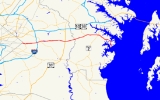
Maryland Route 214 is an east–west state highway
that runs through Prince George's County
and Anne Arundel County within the U.S. state
of Maryland
. Central Avenue runs along the center of Prince George's County and divides it into north and south. Points of interest near Route 214 are Watkins Regional Park, Six Flags America
amusement park, the Evangel Temple and FedEx Field, the home of the Washington Redskins
.
at the Southern Avenue intersection, the latter of which forms the city line. MD 214 passes through suburbs in Capitol Heights
and merges into East Capitol Street, widening the two-lane street into a six-lane divided boulevard. The route continues east as it interchanges with the Capital Beltway, and then, MD 202. As the road's surroundings grow more wooded, the route interchanges with US 301
, featuring a very widespread set of ramps which allows merging into US 301 on the inside lanes.
East of US 301, the road narrows to two lanes with shoulders, and the surroundings become much more rural, featuring expanses of fields and forests as it crosses the Patuxent River into Anne Arundel County. Continuing in much the same fashion as it did in Prince George's, MD 214 passes through Davidsonville
, and later intersects MD 2
just southwest of Londontowne
, at which point the road turns southeast. The road works its way south to Mayo
, where its name changes to Beverly Avenue upon crossing Rogers Road. As it curves to the east suddenly near the south end of town, Beverly Avenue leaves MD 214, and the road follows Grande View Avenue to the end of the road at a gate.
State highway
State highway, state road or state route can refer to one of three related concepts, two of them related to a state or provincial government in a country that is divided into states or provinces :#A...
that runs through Prince George's County
Prince George's County, Maryland
Prince George's County is a county located in the U.S. state of Maryland, immediately north, east, and south of Washington, DC. As of 2010, it has a population of 863,420 and is the wealthiest African-American majority county in the nation....
and Anne Arundel County within the U.S. state
U.S. state
A U.S. state is any one of the 50 federated states of the United States of America that share sovereignty with the federal government. Because of this shared sovereignty, an American is a citizen both of the federal entity and of his or her state of domicile. Four states use the official title of...
of Maryland
Maryland
Maryland is a U.S. state located in the Mid Atlantic region of the United States, bordering Virginia, West Virginia, and the District of Columbia to its south and west; Pennsylvania to its north; and Delaware to its east...
. Central Avenue runs along the center of Prince George's County and divides it into north and south. Points of interest near Route 214 are Watkins Regional Park, Six Flags America
Six Flags America
Six Flags America is a family theme park and water park located in Mitchellville, Prince George's County, Maryland. It is situated east of Washington D.C. and southwest of Baltimore. The park covers , 131 of which is currently used for park operations...
amusement park, the Evangel Temple and FedEx Field, the home of the Washington Redskins
Washington Redskins
The Washington Redskins are a professional American football team and members of the East Division of the National Football Conference in the National Football League . The team plays at FedExField in Landover, Maryland, while its headquarters and training facility are at Redskin Park in Ashburn,...
.
Route description
Maryland Route 214 carries Central Avenue out of Washington, D.C.Washington, D.C.
Washington, D.C., formally the District of Columbia and commonly referred to as Washington, "the District", or simply D.C., is the capital of the United States. On July 16, 1790, the United States Congress approved the creation of a permanent national capital as permitted by the U.S. Constitution....
at the Southern Avenue intersection, the latter of which forms the city line. MD 214 passes through suburbs in Capitol Heights
Capitol Heights, Maryland
Capitol Heights is a town in Prince George's County, Maryland, United States. The population was 4,138 at the 2000 census. Development around the Capitol Heights Metro station has medical facilities and eateries to support the community...
and merges into East Capitol Street, widening the two-lane street into a six-lane divided boulevard. The route continues east as it interchanges with the Capital Beltway, and then, MD 202. As the road's surroundings grow more wooded, the route interchanges with US 301
U.S. Route 301 in Maryland
U.S. Route 301 in Maryland is a major highway that runs from Delaware to the Governor Harry W. Nice Memorial Bridge into Virginia. It passes through three of Maryland's four main regions: the Eastern Shore, the Baltimore-Washington Metropolitan Area, and Southern Maryland...
, featuring a very widespread set of ramps which allows merging into US 301 on the inside lanes.
East of US 301, the road narrows to two lanes with shoulders, and the surroundings become much more rural, featuring expanses of fields and forests as it crosses the Patuxent River into Anne Arundel County. Continuing in much the same fashion as it did in Prince George's, MD 214 passes through Davidsonville
Davidsonville, Maryland
Davidsonville is an unincorporated community in central Anne Arundel County, Maryland, USA. It is a semi-rural community composed mostly of farms and suburban-like developments and is a good example of an "exurb." Davidsonville has relatively little commercial development and no high-density housing...
, and later intersects MD 2
Maryland Route 2
Maryland Route 2 is the longest state highway in the U.S. state of Maryland. The route runs from Solomons Island in Calvert County north to an intersection with U.S. Route 1 and U.S. Route 40 Truck in Baltimore...
just southwest of Londontowne
Londontowne, Maryland
Londontowne is a census-designated place in Anne Arundel County, Maryland, United States. The population was 7,595 at the 2000 census.-History:...
, at which point the road turns southeast. The road works its way south to Mayo
Mayo, Maryland
Mayo is a census-designated place in Anne Arundel County, Maryland, United States. The population was 3,153 at the 2000 census. Its beach was formerly a popular weekend resort.-Geography:Mayo is located at ....
, where its name changes to Beverly Avenue upon crossing Rogers Road. As it curves to the east suddenly near the south end of town, Beverly Avenue leaves MD 214, and the road follows Grande View Avenue to the end of the road at a gate.
Junction list
| County | Location | Mile | Intersection | Notes |
|---|---|---|---|---|
| Prince George's Prince George's County, Maryland Prince George's County is a county located in the U.S. state of Maryland, immediately north, east, and south of Washington, DC. As of 2010, it has a population of 863,420 and is the wealthiest African-American majority county in the nation.... |
Capitol Heights Capitol Heights, Maryland Capitol Heights is a town in Prince George's County, Maryland, United States. The population was 4,138 at the 2000 census. Development around the Capitol Heights Metro station has medical facilities and eateries to support the community... |
0.00 | East Capitol Street East Capitol Street East Capitol Street is a major street that divides the northeast and southeast quadrants of Washington, D.C. It runs due east from the United States Capitol to the DC-Maryland border. The street is uninterrupted until Lincoln Park then continues eastward to Robert F. Kennedy Memorial Stadium... west |
Washington, D.C. Washington, D.C. Washington, D.C., formally the District of Columbia and commonly referred to as Washington, "the District", or simply D.C., is the capital of the United States. On July 16, 1790, the United States Congress approved the creation of a permanent national capital as permitted by the U.S. Constitution.... border, western terminus |
| 0.80 | ||||
| Kettering Kettering, Maryland Kettering is an unincorporated area and census-designated place in Prince George's County, Maryland, United States. The population was 11,008 at the 2000 census, primarily African-American. The name Kettering was created by a suburban housing developer in the 1960s when development began... |
3.67 | , Richmond, VA Richmond, Virginia Richmond is the capital of the Commonwealth of Virginia, in the United States. It is an independent city and not part of any county. Richmond is the center of the Richmond Metropolitan Statistical Area and the Greater Richmond area... |
I-95/495 exit 15 | |
| 4.61 | Interchange | |||
| 6.77 | ||||
| Bowie Bowie, Maryland Bowie is a city in Prince George's County, Maryland, United States. The population was 54,727 at the 2010 census. Bowie has grown from a small railroad stop to the largest municipality in Prince George's County, and the fifth most populous city and third largest city by area in the state of... |
10.85 | Interchange | ||
| Anne Arundel Anne Arundel County, Maryland Anne Arundel County is a county located in the U.S. state of Maryland. It is named for Anne Arundell , a member of the ancient family of Arundells in Cornwall, England and the wife of Cæcilius Calvert, 2nd Baron Baltimore. Its county seat is Annapolis, which is also the capital of the state... |
Davidsonville Davidsonville, Maryland Davidsonville is an unincorporated community in central Anne Arundel County, Maryland, USA. It is a semi-rural community composed mostly of farms and suburban-like developments and is a good example of an "exurb." Davidsonville has relatively little commercial development and no high-density housing... |
16.09 | ||
| Mayo Mayo, Maryland Mayo is a census-designated place in Anne Arundel County, Maryland, United States. The population was 3,153 at the 2000 census. Its beach was formerly a popular weekend resort.-Geography:Mayo is located at .... |
19.47 | |||
| Londontowne Londontowne, Maryland Londontowne is a census-designated place in Anne Arundel County, Maryland, United States. The population was 7,595 at the 2000 census.-History:... |
20.06 | |||
| 20.83 | ||||
| Beverly Beach Beverly Beach, Maryland Beverly Beach is an unincorporated community in Anne Arundel County, Maryland, United States.... |
24.97 | Road end | Eastern terminus |