
Maryland Route 189
Encyclopedia
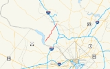
Maryland Route 189, better known as Falls Road, is a road in Montgomery County, Maryland
. The road runs from River Road
in Potomac
northeast to Maryland Avenue
near Rockville
. Formerly, Route 189 ran from MacArthur Boulevard in Potomac to Maryland Route 28
in the center of Rockville.
. Following Falls Road north on a two-lane undivided alignment, the route exits a commercial area and travels to the north, curving through a residential area with several side streets to more homes. The route, largely wooded, also provides access to many of Potomac's services, such as a community center and a fire department. The route curves to the east at a very wide intersection near Potomic Tennis Lane and passes south and east of a large golf course. Re-entering the wooded area, MD 189 passes by several school buildings amid the homes, before a large transmission line clearing crosses the road. The route returns to residential development, dualizing shortly before it meets Interstate 270
at a single-point urban interchange
. The Maryland route designation is dropped at the very next intersection, and the two carriageways combine and continue north as Great Falls Road.
.
Montgomery County, Maryland
Montgomery County is a county in the U.S. state of Maryland, situated just to the north of Washington, D.C., and southwest of the city of Baltimore. It is one of the most affluent counties in the United States, and has the highest percentage of residents over 25 years of age who hold post-graduate...
. The road runs from River Road
Maryland Route 190
Maryland Route 190, or River Road, is a major state highway through southern Montgomery County, Maryland, United States.-Route description:MD 190 begins at MD 112's western terminus in Seneca, and ends at the Montgomery County/Washington, D.C. border...
in Potomac
Potomac, Maryland
Potomac is a census-designated place in Montgomery County, Maryland, United States, named for the nearby Potomac River. The population was 44,822 at the 2000 census. The Potomac area is known for its very affluent and highly-educated residents. In 2009 CNNMoney.com listed Potomac as the fourth...
northeast to Maryland Avenue
near Rockville
Rockville, Maryland
Rockville is the county seat of Montgomery County, Maryland, United States. It is a major incorporated city in the central part of Montgomery County and forms part of the Baltimore-Washington Metropolitan Area. The 2010 U.S...
. Formerly, Route 189 ran from MacArthur Boulevard in Potomac to Maryland Route 28
Maryland Route 28
Maryland Route 28 is a state highway in the U.S. state of Maryland. The state highway runs from U.S. Route 15 in Point of Rocks east to MD 182 in Norwood. The western portion of MD 28 is a rural highway connecting several villages in southern Frederick County and western Montgomery County...
in the center of Rockville.
Route description
Maryland Route 189 begins at an intersection with MD 190 (River Road) in PotomacPotomac, Maryland
Potomac is a census-designated place in Montgomery County, Maryland, United States, named for the nearby Potomac River. The population was 44,822 at the 2000 census. The Potomac area is known for its very affluent and highly-educated residents. In 2009 CNNMoney.com listed Potomac as the fourth...
. Following Falls Road north on a two-lane undivided alignment, the route exits a commercial area and travels to the north, curving through a residential area with several side streets to more homes. The route, largely wooded, also provides access to many of Potomac's services, such as a community center and a fire department. The route curves to the east at a very wide intersection near Potomic Tennis Lane and passes south and east of a large golf course. Re-entering the wooded area, MD 189 passes by several school buildings amid the homes, before a large transmission line clearing crosses the road. The route returns to residential development, dualizing shortly before it meets Interstate 270
Interstate 270 (Maryland)
Interstate 270 is a auxiliary Interstate Highway in the U.S. state of Maryland that travels between Interstate 495 just north of Bethesda, Montgomery County and Interstate 70 in the city of Frederick in Frederick County. It consists of the mainline as well as a spur that provides access to and...
at a single-point urban interchange
Single-point urban interchange
A single-point urban interchange , also called a single-point interchange or single-point diamond interchange , is a type of highway interchange...
. The Maryland route designation is dropped at the very next intersection, and the two carriageways combine and continue north as Great Falls Road.
History
As part of a route swap with Montgomery County, the state of Maryland truncated the route in the late 1990s (year uncertain); the southern terminus is now at Maryland 190, and the northern terminus is now at the intersection of Great Falls Road and Maryland Avenue just north of I-270 exit 5.Junction list
The entire route is in Montgomery CountyMontgomery County, Maryland
Montgomery County is a county in the U.S. state of Maryland, situated just to the north of Washington, D.C., and southwest of the city of Baltimore. It is one of the most affluent counties in the United States, and has the highest percentage of residents over 25 years of age who hold post-graduate...
.
| Location | Mile |
Intersection | Notes |
|---|---|---|---|
| Potomac Potomac, Maryland Potomac is a census-designated place in Montgomery County, Maryland, United States, named for the nearby Potomac River. The population was 44,822 at the 2000 census. The Potomac area is known for its very affluent and highly-educated residents. In 2009 CNNMoney.com listed Potomac as the fourth... |
0.00 | Southern terminus | |
| Rockville Rockville, Maryland Rockville is the county seat of Montgomery County, Maryland, United States. It is a major incorporated city in the central part of Montgomery County and forms part of the Baltimore-Washington Metropolitan Area. The 2010 U.S... |
4.87 | , Washington Washington, D.C. Washington, D.C., formally the District of Columbia and commonly referred to as Washington, "the District", or simply D.C., is the capital of the United States. On July 16, 1790, the United States Congress approved the creation of a permanent national capital as permitted by the U.S. Constitution.... |
I-270 exit 5 |
| 5.05 | Maryland Avenue/Potomac Valley Road | Northern terminus |