
Maryland Route 169
Encyclopedia
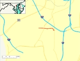
Maryland Route 169, known locally as Maple Road, is an east–west highway in Anne Arundel County, Maryland
. The route heads east, traveling from Hammonds Ferry Rd (Old MD 167) to its intersection with Maryland Route 648
, where the route ends.
area of Anne Arundel County
, traveling east through a residential area. The route crosses the MTA
Light Rail line at grade just prior to its signalized intersection with Camp Meade Road
. Past Camp Meade Road, MD 169 continues unassumingly east through Linthicum, passing several minor county roads prior to ending at its signalized intersection with Baltimore Annapolis Blvd
. The road maintains two lanes along its entire length in addition to a 30 MPH speed limit.
, Anne Arundel County
.
Maryland
Maryland is a U.S. state located in the Mid Atlantic region of the United States, bordering Virginia, West Virginia, and the District of Columbia to its south and west; Pennsylvania to its north; and Delaware to its east...
. The route heads east, traveling from Hammonds Ferry Rd (Old MD 167) to its intersection with Maryland Route 648
Maryland Route 648
Maryland Route 648 is a collection of state highways in the U.S. state of Maryland. These highways are sections of Baltimore–Annapolis Boulevard, the old alignment of MD 2 between Annapolis and Glen Burnie. These segments were bypassed when MD 2 was moved to Governor Ritchie Highway, a...
, where the route ends.
Route description
MD 169 starts at a signalized T-intersection with Hammonds Ferry Road (Old MD 167) in the LinthicumLinthicum, Maryland
Linthicum is a census-designated place and an unincorporated community in Anne Arundel County, Maryland, United States. The population was 7,539 at the 2000 census. It is the approximate location of Baltimore-Washington International Thurgood Marshall Airport...
area of Anne Arundel County
Anne Arundel County, Maryland
Anne Arundel County is a county located in the U.S. state of Maryland. It is named for Anne Arundell , a member of the ancient family of Arundells in Cornwall, England and the wife of Cæcilius Calvert, 2nd Baron Baltimore. Its county seat is Annapolis, which is also the capital of the state...
, traveling east through a residential area. The route crosses the MTA
Maryland Transit Administration
The Maryland Transit Administration is a state-operated mass transit administration in Maryland, and is part of the Maryland Department of Transportation. It is better known as MTA Maryland to avoid confusion with other cities' transit agencies who share the initials MTA. The MTA operates a...
Light Rail line at grade just prior to its signalized intersection with Camp Meade Road
Maryland Route 170
Maryland Route 170 is a roughly 13-mile-long road in Anne Arundel County.-Route description:MD 170 begins at the intersection of MD 175 Annapolis Road and Piney Orchard Parkway, in Odenton. It runs north towards Severn, interchanging with MD 32 northwest of the town...
. Past Camp Meade Road, MD 169 continues unassumingly east through Linthicum, passing several minor county roads prior to ending at its signalized intersection with Baltimore Annapolis Blvd
Maryland Route 648
Maryland Route 648 is a collection of state highways in the U.S. state of Maryland. These highways are sections of Baltimore–Annapolis Boulevard, the old alignment of MD 2 between Annapolis and Glen Burnie. These segments were bypassed when MD 2 was moved to Governor Ritchie Highway, a...
. The road maintains two lanes along its entire length in addition to a 30 MPH speed limit.
Junction list
The entire route is in LinthicumLinthicum, Maryland
Linthicum is a census-designated place and an unincorporated community in Anne Arundel County, Maryland, United States. The population was 7,539 at the 2000 census. It is the approximate location of Baltimore-Washington International Thurgood Marshall Airport...
, Anne Arundel County
Anne Arundel County, Maryland
Anne Arundel County is a county located in the U.S. state of Maryland. It is named for Anne Arundell , a member of the ancient family of Arundells in Cornwall, England and the wife of Cæcilius Calvert, 2nd Baron Baltimore. Its county seat is Annapolis, which is also the capital of the state...
.
| Mile | Intersection | Notes |
|---|---|---|
| 0.00 | Hammonds Ferry Road | Former MD 167 Western terminus |
| 0.32 | ||
| 0.97 | Eastern terminus | |