
Marlboro County, South Carolina
Encyclopedia
Marlboro County is a county located in the U.S. state
of South Carolina
. The 2000 census recorded its population to be 28,818. The 2005 census estimate placed the population at 28,021. Its county seat
is Bennettsville
.
 The first inhabitants of what would become Marlboro County were the Pee Dee
. The first Europeans to arrive in the area were Welsh settlers
leaving Pennsylvania. In 1737, they established the first settlement which was called Welsh Neck.
On 12 March 1785, Marlboro County was established by law. It was named for the Duke of Marlborough
. Bennettsville, its county seat, was founded in 1819 as the city of Carlisle.
, the county has a total area of 485 square miles (1,256.1 km²), of which 480 square miles (1,243.2 km²) is land and 6 square miles (15.5 km²) (1.15%) is water.
of 2000, there were 28,818 people, 10,478 households, and 7,334 families residing in the county. The population density
was 60 people per square mile (23/km²). There were 11,894 housing units at an average density of 25 per square mile (10/km²). The racial makeup of the county was 44.49% White
, 50.73% Black
or African American
, 3.36% Native American
, 0.24% Asian
, 0.24% from other races
, and 0.95% from two or more races. 0.71% of the population were Hispanic
or Latino
of any race.
There were 10,478 households out of which 32.00% had children under the age of 18 living with them, 42.60% were married couples
living together, 22.20% had a female householder with no husband present, and 30.00% were non-families. 26.90% of all households were made up of individuals and 11.00% had someone living alone who was 65 years of age or older. The average household size was 2.59 and the average family size was 3.14.
In the county, the population was spread out with 26.20% under the age of 18, 9.30% from 18 to 24, 29.40% from 25 to 44, 22.80% from 45 to 64, and 12.30% who were 65 years of age or older. The median age was 35 years. For every 100 females there were 96.30 males. For every 100 females age 18 and over, there were 93.10 males.
The median income for a household in the county was $26,598, and the median income for a family was $32,019. Males had a median income of $25,896 versus $20,590 for females. The per capita income
for the county was $13,385. About 17.70% of families and 21.70% of the population were below the poverty line, including 29.20% of those under age 18 and 22.70% of those age 65 or over.
, the county used to vote overwhelmingly Democratic, giving 100% of its vote to the party in 1924. It has mostly remained solidly Democratic in the last 48 years, except for the 1972 election
where Richard Nixon
won every county in the state including Marlboro. More recently the county went strongly for Barack Obama
who received 62.4% of the vote in the 2008 U.S. presidential election
. Further the Democratic candidate has received over 58% in all elections from 1992 to 2004.
U.S. state
A U.S. state is any one of the 50 federated states of the United States of America that share sovereignty with the federal government. Because of this shared sovereignty, an American is a citizen both of the federal entity and of his or her state of domicile. Four states use the official title of...
of South Carolina
South Carolina
South Carolina is a state in the Deep South of the United States that borders Georgia to the south, North Carolina to the north, and the Atlantic Ocean to the east. Originally part of the Province of Carolina, the Province of South Carolina was one of the 13 colonies that declared independence...
. The 2000 census recorded its population to be 28,818. The 2005 census estimate placed the population at 28,021. Its county seat
County seat
A county seat is an administrative center, or seat of government, for a county or civil parish. The term is primarily used in the United States....
is Bennettsville
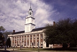
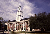
Bennettsville, South Carolina
Bennettsville is a city in and the county seat of Marlboro County, South Carolina, United States. and home to the Bennettsville Historic District...
.
History
Pee Dee (tribe)
The Pee Dee tribe are a nation of Native Americans of the southeast United States, especially the Low Country of present-day South Carolina. Several tribes are recognized by the state, although none has federal recognition. The Pee Dee River and the Pee Dee region of South Carolina were named for...
. The first Europeans to arrive in the area were Welsh settlers
Welsh people
The Welsh people are an ethnic group and nation associated with Wales and the Welsh language.John Davies argues that the origin of the "Welsh nation" can be traced to the late 4th and early 5th centuries, following the Roman departure from Britain, although Brythonic Celtic languages seem to have...
leaving Pennsylvania. In 1737, they established the first settlement which was called Welsh Neck.
On 12 March 1785, Marlboro County was established by law. It was named for the Duke of Marlborough
John Churchill, 1st Duke of Marlborough
John Churchill, 1st Duke of Marlborough, Prince of Mindelheim, KG, PC , was an English soldier and statesman whose career spanned the reigns of five monarchs through the late 17th and early 18th centuries...
. Bennettsville, its county seat, was founded in 1819 as the city of Carlisle.
Geography
According to the U.S. Census BureauUnited States Census Bureau
The United States Census Bureau is the government agency that is responsible for the United States Census. It also gathers other national demographic and economic data...
, the county has a total area of 485 square miles (1,256.1 km²), of which 480 square miles (1,243.2 km²) is land and 6 square miles (15.5 km²) (1.15%) is water.
Adjacent Counties
- Richmond County, North CarolinaRichmond County, North Carolina-Demographics:As of the census of 2000, there were 46,564 people, 17,873 households, and 12,582 families residing in the county. The population density was 98 people per square mile . There were 19,886 housing units at an average density of 42 per square mile...
- north - Scotland County, North CarolinaScotland County, North Carolina-Demographics:As of the census of 2000, there were 35,998 people, 13,399 households, and 9,674 families residing in the county. The population density was 113 people per square mile . There were 14,693 housing units at an average density of 46 per square mile...
- northeast - Robeson County, North CarolinaRobeson County, North CarolinaRobeson County is a county in the U.S. state of North Carolina. As of 2010 it had a population of 134,168. Since then, it has been one of the 10% of United States counties that were majority-minority; its combined population of American Indian, African American and Latino residents comprise over...
- east - Dillon County, South Carolina - east
- Florence County, South CarolinaFlorence County, South CarolinaFlorence is a county located in the U.S. state of South Carolina. In 2000, its population was recorded to be 125,761; in 2005, the U.S. Census Bureau estimated that its population had reached 131,097. Its county seat is Florence. The county's population is about 60% urban and it comprises part of...
- south - Darlington County, South Carolina - southwest
- Chesterfield County, South CarolinaChesterfield County, South Carolina-Demographics:As of the census of 2000, there were 42,768 people, 16,557 households, and 11,705 families residing in the county. The population density was 54 people per square mile . There were 18,818 housing units at an average density of 24 per square mile...
- west - Anson County, North CarolinaAnson County, North Carolina-See also:*National Register of Historic Places listings in Anson County, North Carolina-External links:*...
- northwest
Demographics
As of the censusCensus
A census is the procedure of systematically acquiring and recording information about the members of a given population. It is a regularly occurring and official count of a particular population. The term is used mostly in connection with national population and housing censuses; other common...
of 2000, there were 28,818 people, 10,478 households, and 7,334 families residing in the county. The population density
Population density
Population density is a measurement of population per unit area or unit volume. It is frequently applied to living organisms, and particularly to humans...
was 60 people per square mile (23/km²). There were 11,894 housing units at an average density of 25 per square mile (10/km²). The racial makeup of the county was 44.49% White
Race (United States Census)
Race and ethnicity in the United States Census, as defined by the Federal Office of Management and Budget and the United States Census Bureau, are self-identification data items in which residents choose the race or races with which they most closely identify, and indicate whether or not they are...
, 50.73% Black
Race (United States Census)
Race and ethnicity in the United States Census, as defined by the Federal Office of Management and Budget and the United States Census Bureau, are self-identification data items in which residents choose the race or races with which they most closely identify, and indicate whether or not they are...
or African American
Race (United States Census)
Race and ethnicity in the United States Census, as defined by the Federal Office of Management and Budget and the United States Census Bureau, are self-identification data items in which residents choose the race or races with which they most closely identify, and indicate whether or not they are...
, 3.36% Native American
Race (United States Census)
Race and ethnicity in the United States Census, as defined by the Federal Office of Management and Budget and the United States Census Bureau, are self-identification data items in which residents choose the race or races with which they most closely identify, and indicate whether or not they are...
, 0.24% Asian
Race (United States Census)
Race and ethnicity in the United States Census, as defined by the Federal Office of Management and Budget and the United States Census Bureau, are self-identification data items in which residents choose the race or races with which they most closely identify, and indicate whether or not they are...
, 0.24% from other races
Race (United States Census)
Race and ethnicity in the United States Census, as defined by the Federal Office of Management and Budget and the United States Census Bureau, are self-identification data items in which residents choose the race or races with which they most closely identify, and indicate whether or not they are...
, and 0.95% from two or more races. 0.71% of the population were Hispanic
Race (United States Census)
Race and ethnicity in the United States Census, as defined by the Federal Office of Management and Budget and the United States Census Bureau, are self-identification data items in which residents choose the race or races with which they most closely identify, and indicate whether or not they are...
or Latino
Race (United States Census)
Race and ethnicity in the United States Census, as defined by the Federal Office of Management and Budget and the United States Census Bureau, are self-identification data items in which residents choose the race or races with which they most closely identify, and indicate whether or not they are...
of any race.
There were 10,478 households out of which 32.00% had children under the age of 18 living with them, 42.60% were married couples
Marriage
Marriage is a social union or legal contract between people that creates kinship. It is an institution in which interpersonal relationships, usually intimate and sexual, are acknowledged in a variety of ways, depending on the culture or subculture in which it is found...
living together, 22.20% had a female householder with no husband present, and 30.00% were non-families. 26.90% of all households were made up of individuals and 11.00% had someone living alone who was 65 years of age or older. The average household size was 2.59 and the average family size was 3.14.
In the county, the population was spread out with 26.20% under the age of 18, 9.30% from 18 to 24, 29.40% from 25 to 44, 22.80% from 45 to 64, and 12.30% who were 65 years of age or older. The median age was 35 years. For every 100 females there were 96.30 males. For every 100 females age 18 and over, there were 93.10 males.
The median income for a household in the county was $26,598, and the median income for a family was $32,019. Males had a median income of $25,896 versus $20,590 for females. The per capita income
Per capita income
Per capita income or income per person is a measure of mean income within an economic aggregate, such as a country or city. It is calculated by taking a measure of all sources of income in the aggregate and dividing it by the total population...
for the county was $13,385. About 17.70% of families and 21.70% of the population were below the poverty line, including 29.20% of those under age 18 and 22.70% of those age 65 or over.
Politics
Part of the Solid SouthSolid South
Solid South is the electoral support of the Southern United States for the Democratic Party candidates for nearly a century from 1877, the end of Reconstruction, to 1964, during the middle of the Civil Rights era....
, the county used to vote overwhelmingly Democratic, giving 100% of its vote to the party in 1924. It has mostly remained solidly Democratic in the last 48 years, except for the 1972 election
United States presidential election, 1972
The United States presidential election of 1972 was the 47th quadrennial United States presidential election. It was held on November 7, 1972. The Democratic Party's nomination was eventually won by Senator George McGovern, who ran an anti-war campaign against incumbent Republican President Richard...
where Richard Nixon
Richard Nixon
Richard Milhous Nixon was the 37th President of the United States, serving from 1969 to 1974. The only president to resign the office, Nixon had previously served as a US representative and senator from California and as the 36th Vice President of the United States from 1953 to 1961 under...
won every county in the state including Marlboro. More recently the county went strongly for Barack Obama
Barack Obama
Barack Hussein Obama II is the 44th and current President of the United States. He is the first African American to hold the office. Obama previously served as a United States Senator from Illinois, from January 2005 until he resigned following his victory in the 2008 presidential election.Born in...
who received 62.4% of the vote in the 2008 U.S. presidential election
United States presidential election, 2008
The United States presidential election of 2008 was the 56th quadrennial presidential election. It was held on November 4, 2008. Democrat Barack Obama, then the junior United States Senator from Illinois, defeated Republican John McCain, the senior U.S. Senator from Arizona. Obama received 365...
. Further the Democratic candidate has received over 58% in all elections from 1992 to 2004.
Cities and towns
- BennettsvilleBennettsville, South CarolinaBennettsville is a city in and the county seat of Marlboro County, South Carolina, United States. and home to the Bennettsville Historic District...
- BlenheimBlenheim, South CarolinaBlenheim is a town in Marlboro County, South Carolina, United States. The population was 137 at the 2000 census. It is named for Blenheim Palace in Oxfordshire, England which itself is named for the Battle of Blenheim, a major English victory of the War of the Spanish Succession at what is now...
- ClioClio, South CarolinaClio is a town in Marlboro County, South Carolina, United States. The population was 774 at the 2000 census.-Geography:Clio is located at .According to the United States Census Bureau, the town has a total area of , all of it land...
- McCollMcColl, South CarolinaMcColl is a town in Marlboro County, South Carolina, United States, located within 1.5 miles of the border with North Carolina. The population was 2,498 at the 2000 census.-Geography:McColl is located at ....
- TatumTatum, South CarolinaTatum is a town in Marlboro County, South Carolina, United States. The population was 69 at the 2000 census.-Geography:Tatum is located at .According to the United States Census Bureau, the town has a total area of , all of it land....
- WallaceWallace, South CarolinaWallace is an unincorporated community in northwestern Marlboro County, South Carolina, United States. It lies at the intersection of U.S. Route 1 with SC 9 and SC 177, northwest of the city of Bennettsville, the county seat of Marlboro County. Its elevation is 151&feet...
Airports
- Marlboro County JetportMarlboro County JetportMarlboro County Jetport , also known as H.E. Avent Field, is a county-owned public-use airport located three nautical miles west of the central business district of Bennettsville, in Marlboro County, South Carolina, United States....
- Myrtle Beach International Airport (MYR) 76.8 Miles South - South - East of BennettsvilleMyrtle Beach International AirportMyrtle Beach International Airport is a county-owned public-use airport located three nautical miles southwest of the central business district of Myrtle Beach, in Horry County, South Carolina, United States...
- Charlotte International Airport (CLT) 81.3 Miles West - North - West of BennettsvilleCharlotte/Douglas International AirportCharlotte Douglas International Airport is a joint civil-military public international airport located in Charlotte, North Carolina. Established in 1935 as Charlotte Municipal Airport, in 1954 the airport was renamed Douglas Municipal Airport after former Charlotte mayor Ben Elbert Douglas, Sr...
- Clio Crop Care Airport (9W9)