
Maranoa, Queensland
Encyclopedia
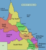
The Maranoa is the name given to an area of southern Queensland
. Some refer to the Maranoa as the Western Downs. The Maranoa is an eastern part of the larger, mostly arid South West region of Queensland. To the east is the agricultural region of the Darling Downs
and in the west is the dry Channel Country
.
 The traditional agriculture is sheep and cattle grazing suitable for the rangeland landscape and sub-tropical climate of the region. The Balonne River
and Maranoa River
are the two main catchments in the Maranoa. The Warrego Highway
, Carnarvon Highway
and Balonne Highway
are the major road routes across the region.
Queensland
Queensland is a state of Australia, occupying the north-eastern section of the mainland continent. It is bordered by the Northern Territory, South Australia and New South Wales to the west, south-west and south respectively. To the east, Queensland is bordered by the Coral Sea and Pacific Ocean...
. Some refer to the Maranoa as the Western Downs. The Maranoa is an eastern part of the larger, mostly arid South West region of Queensland. To the east is the agricultural region of the Darling Downs
Darling Downs, Queensland
The Darling Downs is a farming region on the western slopes of the Great Dividing Range in southern Queensland, Australia. The Downs are to the west of South East Queensland and are one of eleven major regions of Queensland....
and in the west is the dry Channel Country
Channel Country
The Channel Country is region of outback Australia located mostly in the state of Queensland but also in portions of South Australia, Northern Territory and New South Wales. The name comes from the numerous intertwined rivulets that cross the region, which cover 150,000 km²...
.
Balonne River
The Balonne River, part of the Murray-Darling Basin system, is a short but important part of the inland river group of south-eastern Queensland. This river is a continuation of the Condamine River. After flowing through Surat the river flows south south-westerly down through the E.J...
and Maranoa River
Maranoa River
The Maranoa River is a large river situated in south west Queensland. The Maranoa passes through Mitchell and flows south towards St George. It is a tributary of the Balonne River which eventually flows into the Darling River , so it contributes to the Murray-Darling Basin.The river rises on the...
are the two main catchments in the Maranoa. The Warrego Highway
Warrego Highway
The Warrego Highway is located in southern Queensland, Australia. It connects coastal centres to the south western areas of the state, and is approximately 750 km in length. It takes its name from the Warrego River, which is the endpoint of the highway...
, Carnarvon Highway
Carnarvon Highway
The Carnarvon Highway is a state highway of Queensland, linking Moree south of the NSW/QLD border, via the town of St George, eventually to the township of Rolleston. North of Roma it is known as the Carnarvon Developmental Road. National Route 46 runs from Moree to St George...
and Balonne Highway
Balonne Highway
The Balonne Highway, a state highway of Queensland, is the continuation westward of the Moonie Highway from the town of St George to its termination at Cunnamulla. It follows the Balonne River for the most part and is named after it. There are no settlements of any real size between St George and...
are the major road routes across the region.