
Main Beach, Queensland
Encyclopedia
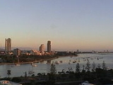
Main Beach is a suburb on the Gold Coast
in Queensland
, Australia
. At the 2006 Census, Main Beach had a population of 3,324.
During the early years in which Southport
was the urban centre of recreational activity at the coast, visitors were ferried across the Broadwater
to surf at the Main Beach so named because it was the main surf beach for the town of Southport
. The area was defined by narrow coastal dune between the sea and the mouth of the Nerang River
. Narrowneck
formed the southern boundary and to the north a spit of sand terminated in a break or bar between the Broadwater
and the sea. A natural basin for boats existed at the mouth of the river. The area became more popular following the construction of the Jubilee Bridge
in 1926 when land was taken up and holiday houses were constructed. Some guest houses were also constructed but little or no permanent population was located in the area. Some evidence remains of the areas early popularity as a surfing beach in the beachfront planting and the kiosk and shelter shed from 1934.
The construction of the new bridge and the deviation of highway to the west of Main Beach in the late 1960s was preceded in the 1950s by early reclamation of the Nerang River to the west of the earlier subdivision
and the area centred on Tedder Avenue dates only from that time. A different subdivision pattern in that portion of Main Beach is the result. Similarly the land to the north of the early subdivision - the sand spit that formed one bank of the bar - was only recently developed. Until the 1870s and 1880s the only activity in this area was limited to facilities associated with the Southport Yacht Club and other maritime activities.
Its use is still limited although resort hotels and theme parks now occupy the land. Revegetation of the Southport Spit
followed the construction of the Gold Coast Seaway
and gives particular character to this area and acts to link the more intensively developed area to the south with the open areas of the Broadwater
and Southern Moreton Bay
. Main Beach property has developed as a high rise area only relatively recently and is focused on Tedder Avenue. It has a sense of more permanent residential neighbourhood than other parts of the high rise coastal strip. The restaurants and coffee shops service this use. Most of the apartment buildings along the foreshore are more modest in scale. The isthmus
at Narrowneck acts as a natural barrier to the more intensively developed area to the south.
The Gold Coast Oceanway
travels on the seaward side of the Southport SLSC but then diverts inland to travel behind beachfront houses of Main Beach down to Narrowneck
. Some local residents would like a new Oceanway pavement constructed along the road reserve between the beachfront houses and the dune area.
There are large amounts of Araucaria heterophylla
- a conifer that isn't native to the area - near the beaches in Main Beach.
Gold Coast, Queensland
Gold Coast is a coastal city of Australia located in South East Queensland, 94km south of the state capital Brisbane. With a population approximately 540,000 in 2010, it is the second most populous city in the state, the sixth most populous city in the country, and also the most populous...
in Queensland
Queensland
Queensland is a state of Australia, occupying the north-eastern section of the mainland continent. It is bordered by the Northern Territory, South Australia and New South Wales to the west, south-west and south respectively. To the east, Queensland is bordered by the Coral Sea and Pacific Ocean...
, Australia
Australia
Australia , officially the Commonwealth of Australia, is a country in the Southern Hemisphere comprising the mainland of the Australian continent, the island of Tasmania, and numerous smaller islands in the Indian and Pacific Oceans. It is the world's sixth-largest country by total area...
. At the 2006 Census, Main Beach had a population of 3,324.
During the early years in which Southport
Southport, Queensland
-Sport:The Southport Sharks Australian rules football club has a presence in the area, including a club and function centre.-Transport:The Broadwaterway is a foreshoreway that encourages pedestrians and cyclists to travel along the Broadwater foreshores of Southport.A ferry terminal is planned for...
was the urban centre of recreational activity at the coast, visitors were ferried across the Broadwater
Gold Coast Broadwater
The Gold Coast Broadwater, also known as Southport Broadwater and Gold Coast Harbour, is a large shallow estuary of water reaching from the locality of Southport to the southern section of the World Heritage Listed Moreton Bay along the eastern coast of Australia...
to surf at the Main Beach so named because it was the main surf beach for the town of Southport
Southport, Queensland
-Sport:The Southport Sharks Australian rules football club has a presence in the area, including a club and function centre.-Transport:The Broadwaterway is a foreshoreway that encourages pedestrians and cyclists to travel along the Broadwater foreshores of Southport.A ferry terminal is planned for...
. The area was defined by narrow coastal dune between the sea and the mouth of the Nerang River
Nerang River
The Nerang River is a river that begins in the McPherson Range in the Gold Coast hinterland and runs through Gold Coast City in South East Queensland, Australia...
. Narrowneck
Narrowneck, Queensland
Narrowneck is the name of a narrow bit of coastline that separates the anabranch of the Nerang River from the southern end of Main Beach and the northern end of Surfers Paradise beach.-Seawalls:...
formed the southern boundary and to the north a spit of sand terminated in a break or bar between the Broadwater
Gold Coast Broadwater
The Gold Coast Broadwater, also known as Southport Broadwater and Gold Coast Harbour, is a large shallow estuary of water reaching from the locality of Southport to the southern section of the World Heritage Listed Moreton Bay along the eastern coast of Australia...
and the sea. A natural basin for boats existed at the mouth of the river. The area became more popular following the construction of the Jubilee Bridge
Southport, Queensland
-Sport:The Southport Sharks Australian rules football club has a presence in the area, including a club and function centre.-Transport:The Broadwaterway is a foreshoreway that encourages pedestrians and cyclists to travel along the Broadwater foreshores of Southport.A ferry terminal is planned for...
in 1926 when land was taken up and holiday houses were constructed. Some guest houses were also constructed but little or no permanent population was located in the area. Some evidence remains of the areas early popularity as a surfing beach in the beachfront planting and the kiosk and shelter shed from 1934.
The construction of the new bridge and the deviation of highway to the west of Main Beach in the late 1960s was preceded in the 1950s by early reclamation of the Nerang River to the west of the earlier subdivision
Subdivision (land)
Subdivision is the act of dividing land into pieces that are easier to sell or otherwise develop, usually via a plat. The former single piece as a whole is then known in the United States as a subdivision...
and the area centred on Tedder Avenue dates only from that time. A different subdivision pattern in that portion of Main Beach is the result. Similarly the land to the north of the early subdivision - the sand spit that formed one bank of the bar - was only recently developed. Until the 1870s and 1880s the only activity in this area was limited to facilities associated with the Southport Yacht Club and other maritime activities.
Its use is still limited although resort hotels and theme parks now occupy the land. Revegetation of the Southport Spit
Southport Spit, Queensland
The Southport Spit lies opposite Southport to the north of Main Beach, Gold Coast. It is a permanent sand spit that separates the Southport Broadwater from the Pacific Ocean....
followed the construction of the Gold Coast Seaway
Gold Coast Seaway
The Gold Coast Seaway or Southport Seaway is the main navigation entrance from the Pacific Ocean into the Gold Coast Broadwater and southern Moreton Bay and is one of Australia’s most significant coastal engineering projects...
and gives particular character to this area and acts to link the more intensively developed area to the south with the open areas of the Broadwater
Gold Coast Broadwater
The Gold Coast Broadwater, also known as Southport Broadwater and Gold Coast Harbour, is a large shallow estuary of water reaching from the locality of Southport to the southern section of the World Heritage Listed Moreton Bay along the eastern coast of Australia...
and Southern Moreton Bay
Moreton Bay
Moreton Bay is a bay on the eastern coast of Australia 45 km from Brisbane, Queensland. It is one of Queensland's most important coastal resources...
. Main Beach property has developed as a high rise area only relatively recently and is focused on Tedder Avenue. It has a sense of more permanent residential neighbourhood than other parts of the high rise coastal strip. The restaurants and coffee shops service this use. Most of the apartment buildings along the foreshore are more modest in scale. The isthmus
Isthmus
An isthmus is a narrow strip of land connecting two larger land areas usually with waterforms on either side.Canals are often built through isthmuses where they may be particularly advantageous to create a shortcut for marine transportation...
at Narrowneck acts as a natural barrier to the more intensively developed area to the south.
The Gold Coast Oceanway
Gold Coast Oceanway
The Gold Coast Oceanway is a foreshoreway along beaches in Gold Coast, Queensland. The Gold Coast Oceanway is a shared use pedestrian and cyclist pathway on the Gold Coast, connecting the Point Danger lighthouse on the New South Wales and Queensland border to the Gold Coast Seaway...
travels on the seaward side of the Southport SLSC but then diverts inland to travel behind beachfront houses of Main Beach down to Narrowneck
Narrowneck, Queensland
Narrowneck is the name of a narrow bit of coastline that separates the anabranch of the Nerang River from the southern end of Main Beach and the northern end of Surfers Paradise beach.-Seawalls:...
. Some local residents would like a new Oceanway pavement constructed along the road reserve between the beachfront houses and the dune area.
There are large amounts of Araucaria heterophylla
Araucaria heterophylla
Araucaria heterophylla is a distinctive conifer, a member of the ancient and now disjointly distributed family Araucariaceae. As its vernacular name Norfolk Island Pine implies, the tree is endemic to Norfolk Island, a small island in the Pacific Ocean between Australia, New Zealand and New...
- a conifer that isn't native to the area - near the beaches in Main Beach.