

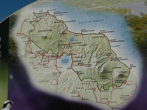
Los Tuxtlas
Encyclopedia
Veracruz
Veracruz, formally Veracruz de Ignacio de la Llave officially Estado Libre y Soberano de Veracruz de Ignacio de la Llave , is one of the 31 states that, along with the Federal District, comprise the 32 federative entities of Mexico. It is divided in 212 municipalities and its capital city is...
, in east central Mexico
Mexico
The United Mexican States , commonly known as Mexico , is a federal constitutional republic in North America. It is bordered on the north by the United States; on the south and west by the Pacific Ocean; on the southeast by Guatemala, Belize, and the Caribbean Sea; and on the east by the Gulf of...
. The region includes the Sierra de Los Tuxtlas
Sierra de los Tuxtlas
The Sierra de Los Tuxtlas are a volcanic belt and mountain range along the southeastern Veracruz Gulf coast in southcentral Mexico....
and stretches from Laguna Alvarado, along the Gulf of Mexico, to Laguna del Ostión, then along the westernmost tributaries of Laguna del Ostión, to the northernmost tributaries of Río Coatzacoalcos, then along the Río San Juan
Río San Juan
Río San Juan may refer to* Río San Juan , Nicaragua* Río San Juan, Dominican Republic* Río San Juan, north-eastern Venezuela* Río San Juan , Mexico...
to its merger with Río Papaloapan flowing into the Gulf of Mexico
Gulf of Mexico
The Gulf of Mexico is a partially landlocked ocean basin largely surrounded by the North American continent and the island of Cuba. It is bounded on the northeast, north and northwest by the Gulf Coast of the United States, on the southwest and south by Mexico, and on the southeast by Cuba. In...
.
Geographically, the Sierra de Los Tuxtlas
Sierra de los Tuxtlas
The Sierra de Los Tuxtlas are a volcanic belt and mountain range along the southeastern Veracruz Gulf coast in southcentral Mexico....
is the volcanic massif centered on Catemaco
Catemaco
Catemaco is a municipality and city in the southeast of Mexican state of Veracruz, in the Sierra de Los Tuxtlas volcanic mountain range, along the Gulf of Mexico...
, bordering on the Gulf of Mexico and encompassing the gulf coast and inland terrain of the volcanic massifs of San Martín Tuxtla, Santa Marta and San Martín Pajapan from the Gulf of Mexico and roughly 100 meters inland to app. 1750 meters above sea level, including parts or all of the 9 counties (municipios) of Ángel R. Cabada
Ángel R. Cabada (municipality)
Ángel R. Cabada is a municipality in Veracruz, Mexico. It is located about 207 km southeast from the state capital Xalapa, and is in the Papaloapan River region between Lerdo de Tejada and San Andrés Tuxtla on the Federal Highway. The municipality of Ángel R...
, Santiago Tuxtla
Santiago Tuxtla
The municipality of Santiago Tuxtla, in the Mexican state of Veracruz, was founded in 1524.The municipality has approximately 51,000 inhabitants and occupies the northwestern slope of Volcano San Martin to the Rio San Juan...
, San Andrés Tuxtla
San Andrés Tuxtla
The municipio of San Andrés Tuxtla is located in the south-central portion of the Mexican state of Veracruz. Its municipal seat is also called San Andrés Tuxtla, located 150 km from the city of Veracruz along Federal Highway 180 in the Sierra de Los Tuxtlas region.The municipality which...
, Catemaco
Catemaco
Catemaco is a municipality and city in the southeast of Mexican state of Veracruz, in the Sierra de Los Tuxtlas volcanic mountain range, along the Gulf of Mexico...
, San Pedro Soteapan, Tatahuicapan de Juárez, Mecayapan
Mecayapan
Mecayapan is a municipality and city in Veracruz, Mexico. It is located in south-east zone of the State of Veracruz, about 428 km from state capital Xalapa. It has a surface of 523.96 km2...
, Pajapan
Pajapan
Pajapan is a municipality and city in Veracruz, Mexico. It is located in south zone of the State of Veracruz, about 496 km from state capital Xalapa. It has a surface of 305.98 km2...
and Hueyapan de Ocampo
Hueyapan de Ocampo
Hueyapan de Ocampo in Veracruz, Mexico. It is located in south zone of the State of Veracruz, about 245 km from state capital Xalapa. It has a surface of 824.18 km2...
.
The Biósfera Los Tuxtlas
Biósfera Los Tuxtlas
The Biósfera Los Tuxtlas is a reserve located in Los Tuxtlas, Veracruz. This area is notable for its diversity of plants and animals and as the northern geographic limit for moist Neotropical forest in North America.-External links:*...
occupies mostly the coastal and higher elevations of the Sierra de Los Tuxtlas, including parts of all the above counties except Hueyapan de Ocampo.
The three counties of Santiago Tuxtla
Santiago Tuxtla
The municipality of Santiago Tuxtla, in the Mexican state of Veracruz, was founded in 1524.The municipality has approximately 51,000 inhabitants and occupies the northwestern slope of Volcano San Martin to the Rio San Juan...
, San Andrés Tuxtla
San Andrés Tuxtla
The municipio of San Andrés Tuxtla is located in the south-central portion of the Mexican state of Veracruz. Its municipal seat is also called San Andrés Tuxtla, located 150 km from the city of Veracruz along Federal Highway 180 in the Sierra de Los Tuxtlas region.The municipality which...
and Catemaco
Catemaco
Catemaco is a municipality and city in the southeast of Mexican state of Veracruz, in the Sierra de Los Tuxtlas volcanic mountain range, along the Gulf of Mexico...
, which share common history, traditions and vicinity of Volcano San Martín Tuxtla, usually refer to themselves as Los Tuxtlas and ignore the rest of the area.
When Los Tuxtlas is referred to as the Olmec
Olmec
The Olmec were the first major Pre-Columbian civilization in Mexico. They lived in the tropical lowlands of south-central Mexico, in the modern-day states of Veracruz and Tabasco....
homeland, Los Tuxtlas includes all of the above plus parts of western Tabasco
Tabasco
Tabasco officially Estado Libre y Soberano de Tabasco is one of the 31 states which, with the Federal District, comprise the 32 Federal Entities of Mexico. It is divided in 17 municipalities and its capital city is Villahermosa....
state.
To confuse the issues even more - the northernmost parts of Los Tuxtlas become part of the Llanura de Sotavento. The southern parts are known as Sierra de Soteapan, or the Sierra de Santa Marta with a subregion known as the Serranía de Bastonal.
Most of the Tuxtlas are considered part of the Papaloapan river basin, the southernmost section is part of the Río Coatzacoalcos river basin, and to keep geographers on their toes, that southern part also becomes part of the Tehuantepec Isthmus.
Politically, the area is a hodgepodge of political districts and has no cohesive representation. The 2005 electoral redistricting threw in some more municipalities into the Tuxtlas region. There is now a new political gambit splitting the area into microregions, Los Tuxtlas and Las Olmecas. It's an effort to ammeliorate poverty, but throws Los Tuxtlas together with several new municipalities.