

London iBus system
Encyclopedia
The London iBus system or officially iBus is an Automatic Vehicle Location
(AVL) system to improve London's buses using technology installed by Siemens AG. The system tracks all of London's 8000 buses to provide passengers with audio visual announcements, improved information on bus arrivals, and to trigger priority at traffic junctions.
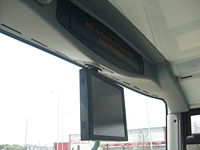 Upon boarding the bus, for example, route 201 serving Herne Hill, iBus will make the announcement "201 to Herne Hill" and display this on the visual displays. As the bus approaches the stop, the on-board system will announce and display the bus stop name.
In addition, the bus driver is able to play recorded announcements such as "Please move down inside the bus", "No standing on the upper deck or stairs please", "Seats are available on the upper deck", and "This bus terminates here please take all your personal belongings with you".
Each bus contains a Windows-based computer that has the details of all 19,000 bus stops in London. The system has over 30,000 announcements for 700 bus routes. Emma Hignett, a radio presenter, was given the job to record all of the announcements used on the iBus system.
The essential part of the system relies on GPS satellite data that roughly determine the location of a bus down to 100 metres. Data collected from GPS is passed into a Kalman filter
, and other data including velocity and temperature is calculated on the bus and transmitted every 30 seconds via GPRS. With the bus network map, this helps the Central System to make a "best guess" of the bus position and depicts the overall image derived from the data provided by all buses, even in areas with poor GPS reception. The Central System can update the countdown signs as before that now has a more accurate prediction derived from all this data. Knowing the location of the bus, controllers have the means to regulate the service more efficiently, and priority can be given to a bus at traffic lights.
CentreComm, the 24/7 Emergency Command and Control Centre, is able to track the location of every bus in the fleet and can be shared this information immediately with the emergency services in the event of an emergency or accident.
With text messaging, bus users can send a text with the bus stop code to receive realtime bus arrival times for that stop. Visually impaired passengers will be able to use the text-to-speech facility on their mobile phones to get the information too. However, users will have the pay the standard network rate for sending the text, plus an additional 12p charge to receive the response.
On the internet, the latest service information is available using mobile web or the internet.
Countdown signs are signs at bus stops giving users information about when the next bus is due. With iBus, Countdown is able to provide real-time information at 2,500 key bus stops in London. Communications improvements have also meant that Countdown can now display service updates, disruption information and network-wide messages. However, the roll out of the new signs that began in 2011 will not be completed until 2012. iBus was integrated with Countdown by Telent. And the signs were supplied, installed and maintenance by ACIS and Trueform.
Automatic vehicle location
Automatic vehicle location is a means for automatically determining the geographic location of a vehicle and transmitting the information to a requester....
(AVL) system to improve London's buses using technology installed by Siemens AG. The system tracks all of London's 8000 buses to provide passengers with audio visual announcements, improved information on bus arrivals, and to trigger priority at traffic junctions.
Announcements
In addition, the bus driver is able to play recorded announcements such as "Please move down inside the bus", "No standing on the upper deck or stairs please", "Seats are available on the upper deck", and "This bus terminates here please take all your personal belongings with you".
Each bus contains a Windows-based computer that has the details of all 19,000 bus stops in London. The system has over 30,000 announcements for 700 bus routes. Emma Hignett, a radio presenter, was given the job to record all of the announcements used on the iBus system.
Tracking
The iBus system aims to provide a better fix on bus locations than the old Selective Vehicle Detection (SVD) system. iBus can locate every bus to an accuracy of about ten metres, or its distance from the nearest stop by around ten seconds. It does this using several instruments:- Global Positioning SystemGlobal Positioning SystemThe Global Positioning System is a space-based global navigation satellite system that provides location and time information in all weather, anywhere on or near the Earth, where there is an unobstructed line of sight to four or more GPS satellites...
(GPS) - OdometerOdometerAn odometer or odograph is an instrument that indicates distance traveled by a vehicle, such as a bicycle or automobile. The device may be electronic, mechanical, or a combination of the two. The word derives from the Greek words hodós and métron...
s, including SpeedometerSpeedometerA speedometer is a gauge that measures and displays the instantaneous speed of a land vehicle. Now universally fitted to motor vehicles, they started to be available as options in the 1900s, and as standard equipment from about 1910 onwards. Speedometers for other vehicles have specific names... - Turn-rate sensor
- Rate gyroRate gyroA rate gyro is a type of gyroscope, which rather than indicating direction, indicates the rate of change of angle with time. If a gyro has only one gimbal ring, with consequently only two planes of freedom, it can be adapted for use as a rate gyro to measure a rate of angular movement.Rate gyros...
The essential part of the system relies on GPS satellite data that roughly determine the location of a bus down to 100 metres. Data collected from GPS is passed into a Kalman filter
Kalman filter
In statistics, the Kalman filter is a mathematical method named after Rudolf E. Kálmán. Its purpose is to use measurements observed over time, containing noise and other inaccuracies, and produce values that tend to be closer to the true values of the measurements and their associated calculated...
, and other data including velocity and temperature is calculated on the bus and transmitted every 30 seconds via GPRS. With the bus network map, this helps the Central System to make a "best guess" of the bus position and depicts the overall image derived from the data provided by all buses, even in areas with poor GPS reception. The Central System can update the countdown signs as before that now has a more accurate prediction derived from all this data. Knowing the location of the bus, controllers have the means to regulate the service more efficiently, and priority can be given to a bus at traffic lights.
CentreComm, the 24/7 Emergency Command and Control Centre, is able to track the location of every bus in the fleet and can be shared this information immediately with the emergency services in the event of an emergency or accident.
Other applications
Although iBus was rolled out in 2008, it was not until 2011 that the data was made available to other applications, such as text messaging and the internet.With text messaging, bus users can send a text with the bus stop code to receive realtime bus arrival times for that stop. Visually impaired passengers will be able to use the text-to-speech facility on their mobile phones to get the information too. However, users will have the pay the standard network rate for sending the text, plus an additional 12p charge to receive the response.
On the internet, the latest service information is available using mobile web or the internet.
Countdown signs are signs at bus stops giving users information about when the next bus is due. With iBus, Countdown is able to provide real-time information at 2,500 key bus stops in London. Communications improvements have also meant that Countdown can now display service updates, disruption information and network-wide messages. However, the roll out of the new signs that began in 2011 will not be completed until 2012. iBus was integrated with Countdown by Telent. And the signs were supplied, installed and maintenance by ACIS and Trueform.