

London Riverside
Encyclopedia
North East (London sub region)
The North East is a sub-region of the London Plan corresponding to the London Boroughs of Tower Hamlets, Newham, Waltham Forest, Redbridge, Havering, Barking and Dagenham, and the City of London. The sub region was established in 2008 and replaced the larger East sub region that had been...
, England and part of the larger Thames Gateway
Thames Gateway
The Thames Gateway is an area of land stretching east from inner east London on both sides of the River Thames and the Thames Estuary. The area, which includes much brownfield land, has been designated a national priority for urban regeneration, taking advantage of the development opportunities...
redevelopment zone. The London Riverside area forms part of the Green Enterprise District
Green Enterprise District
The Green Enterprise District is a regeneration project of the Mayor of London in east London, England, with a stated aim to create a low-carbon economy region in Greater London. It coincides with the Lower Lea Valley and London Riverside sections of the Thames Gateway, which corresponds to parts...
, a project to create a low-carbon economy
Low-carbon economy
A Low-Carbon Economy or Low-Fossil-Fuel Economy is an economy that has a minimal output of greenhouse gas emissions into the environment biosphere, but specifically refers to the greenhouse gas carbon dioxide...
region in Greater London
Greater London
Greater London is the top-level administrative division of England covering London. It was created in 1965 and spans the City of London, including Middle Temple and Inner Temple, and the 32 London boroughs. This territory is coterminate with the London Government Office Region and the London...
.
It is one of two zones whose responsibility for delivery is with London Thames Gateway Development Corporation
London Thames Gateway Development Corporation
The London Thames Gateway Development Corporation is a non-departmental public body sponsored by the Department for Communities and Local Government, with directors appointed by the Secretary of State, including some democratically elected councillors...
; the other is the Lower Lea Valley
Lower Lea Valley
The Lower Lea Valley is the southern end of the Lea Valley, surrounding the River Lea , which runs along the boundary of the London Borough of Tower Hamlets on its western bank and the London Boroughs of Waltham Forest and Newham on its eastern bank, into the River Thames. The river forms the...
redevelopment.
Geography
The area of the London Riverside development stretches from BecktonBeckton
Beckton is part of the London Borough of Newham, England, located east of Charing Cross.Its boundaries are the A13 trunk road to the north, Barking Creek to the east, the Royal Docks to the south, and Prince Regent Lane to the west. The area around Prince Regent Lane is also known as Custom House...
in the London Borough of Newham
London Borough of Newham
The London Borough of Newham is a London borough formed from the towns of West Ham and East Ham, within East London.It is situated east of the City of London, and is north of the River Thames. According to 2006 estimates, Newham has one of the highest ethnic minority populations of all the...
in the west to Wennington
Wennington, London
Wennington is a small village in the London Borough of Havering on the outskirts of east London. It is situated 14.8 miles east of Charing Cross....
in the London Borough of Havering
London Borough of Havering
The London Borough of Havering is a London borough in North East London, England and forms part of Outer London. The principal town in Havering is Romford and the other main communities are Hornchurch, Upminster and Rainham. The borough is mainly characterised by suburban development with large...
in the east. The development spans the River Thames
River Thames
The River Thames flows through southern England. It is the longest river entirely in England and the second longest in the United Kingdom. While it is best known because its lower reaches flow through central London, the river flows alongside several other towns and cities, including Oxford,...
adjacent sections of these boroughs and the London Borough of Barking and Dagenham
London Borough of Barking and Dagenham
In 1801, the civil parishes that form the modern borough had a total population of 1,937; and the area was characterised by farming, woodland and the fishing fleet at Barking. This last industry employed 1,370 men and boys by 1850, but by the end of the century had ceased to exist; replaced by...
. Much of the development will re-use brownfield industrial land on the river. The area totals 35 km². It is expected that by 2016 the London Riverside will provide 20,000 new homes and 25,000 jobs.
The boundaries of the London Riverside have expanded somewhat over time. The original area was bounded by the River Thames
River Thames
The River Thames flows through southern England. It is the longest river entirely in England and the second longest in the United Kingdom. While it is best known because its lower reaches flow through central London, the river flows alongside several other towns and cities, including Oxford,...
to the south and the former A13 road (now the A1306) to the north and stretched only as far west as Barking Reach. It has since expanded to include East Beckton and Barking Town. A smaller area constitutes the London Riverside business improvement district
Business improvement district
A business improvement district is a defined area within which businesses pay an additional tax or fee in order to fund improvements within the district's boundaries. Grant funds acquired by the city for special programs and/or incentives such as tax abatements can be made available to assist...
.
Planned developments
Since October 2005, the London Thames Gateway Development Corporation has taken over planning functions from the local councils for this area. The redevelopment plans include:- East London TransitEast London TransitEast London Transit is a part-segregated bus rapid transit whose first phase opened in 2010, with an additional phase planned to open in 2013. The scheme has been developed by Transport for London due to the existing and anticipated demand for public transport in northeast London caused by the...
- a transport scheme connecting the area to Barking and Ilford
- In Barking and Dagenham:
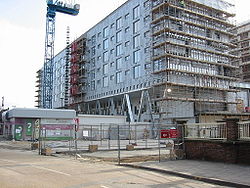
- Barking TownBarkingBarking is a suburban town in the London Borough of Barking and Dagenham, in East London, England. A retail and commercial centre situated in the west of the borough, it lies east of Charing Cross. Barking was in the historic county of Essex until it was absorbed by Greater London. The area is...
- £500 million redevelopment, planned to be strategic centre of London Riverside development - Barking Riverside - 1.8 km², new community with 10,800 new homes, facilities and DLR extensionDocklands Light Railway extension to Dagenham DockThe Docklands Light Railway extension to Dagenham Dock is a proposed, and as yet unfunded, extension of the Docklands Light Railway to Dagenham Dock in east London. It was anticipated that the project could be completed and open for use by 2017. However the public inquiry has been postponed due to...
- CreekmouthCreekmouth-External links:**...
- Dagenham DockDagenham DockDagenham Dock is a place in the London Borough of Barking and Dagenham in London, England. It is located to the south of Dagenham and on the River Thames. It was once the site of a large coaling port and continues to be the location of a small terminal licensed to handle coal off-loading...
- 1.33 km², environmentally sustainable business cluster - South Dagenham - mixed use site
- Barking Town
- In Havering:
- Beam ReachBeam ReachBeam Reach is a redevelopment area in London, England and part of the London Riverside section of the Thames Gateway. It is located in the southern part of the London Borough of Havering, next to the River Thames and the River Beam...
- area for intensification of manufacturing companies, including plans for a new railway station - RainhamRainham, LondonRainham is a suburban town in northeast London, England, and part of the London Borough of Havering. Located east of Charing Cross, it is one of the locally important district centres identified in the London Plan and is surrounded by a residential area, which has grown from the historic village,...
, South HornchurchSouth HornchurchSouth Hornchurch is a place in the London Borough of Havering, east London.It is a suburban development situated 13.6 miles east of Charing Cross. The area is a relatively recent addition, compared with the more mature suburbs in Havering. It was built on open farmland and the former site of RAF...
and Orchard VillageOrchard VillageOrchard Village, formerly known as the Mardyke Estate, is a housing development in London, England.The site is currently undergoing a regeneration as part of the London Riverside part of the Thames Gateway. The estate was transferred from Havering London Borough Council to Old Ford Housing... - WildspaceWildspace Conservation ParkThe Wildspace Conservation Park, also known as London Riverside Conservation Park or Wildspace, is a major new conservation park currently under development. The conservation park is predominantly in London, within the London Borough of Havering, but also extends across the capital's...
, also known as the London Riverside Conservation Park, - 6.4 km², a conservation, recreation and amenity zone at RainhamRainham, LondonRainham is a suburban town in northeast London, England, and part of the London Borough of Havering. Located east of Charing Cross, it is one of the locally important district centres identified in the London Plan and is surrounded by a residential area, which has grown from the historic village,...
- Beam Reach