
Little Hucklow
Encyclopedia
The parish of Little Hucklow is situated in north Derbyshire
. Whilst it is a separate civil parish in the Derbyshire Dales District, the Parish Council is joint with Great Hucklow
, and Grindlow. The parish consists of the village of Little Hucklow and the hamlets of Coplow Dale
and Windmill. The population of the parish is about 120. It lies within the Peak District National Park, under Hucklow Edge. The neighbouring villages are Bradwell, Derbyshire
to the north, Great Hucklow
to the east and Tideswell
to the south. The village lies just west of the B6049 about a mile and a half north of where it crosses the A623 at the Anchor Inn. The village is linear and is alligned east-west.
The parish is highly rural with current farming activitiy being mainly livestock rearing. There was formerly considerable lead mining activity in the parish, including a 600 feet (182.9 m) shaft at High Rake mine. The mine is situated on a large vein about a quarter of a mile west of the hamlet of Windmill in the Liberty of Little Hucklow. This vein is known under different titles as it ranges from the Sir William Hill on the east to beyond Tideslow Top on the west. At High Rake shaft it is called the High Rake, but immediately west of the old Tideswell to Castleton road it is known as Tideslow Rake and past Tideslow Top as White Rake. Eastwardly and beyond Windmill it is called the Hucklow Edge Vein. The foundations of the mine buildings have been excavated by the Peak District Historical Mines Society.
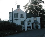
Windmill is a small hamlet in the parish of Little Hucklow, consisting of fifteen houses, and several farms. It is located on the lane that runs west from Windmill Triangle to the Old Castleton Road. There are a number of old houses, one of which was formerly a public house, and the other the village shop and cafe.
Derbyshire
Derbyshire is a county in the East Midlands of England. A substantial portion of the Peak District National Park lies within Derbyshire. The northern part of Derbyshire overlaps with the Pennines, a famous chain of hills and mountains. The county contains within its boundary of approx...
. Whilst it is a separate civil parish in the Derbyshire Dales District, the Parish Council is joint with Great Hucklow
Great Hucklow
Great Hucklow is a small village in the Derbyshire Peak District which nestles under Hucklow Edge between the villages of Tideswell and Bradwell. It has a population of about 100. The area is now mainly agricultural, but the village was formerly a centre of the Derbyshire lead mining industry...
, and Grindlow. The parish consists of the village of Little Hucklow and the hamlets of Coplow Dale
Coplow Dale
Coplow Dale is a small settlement in the civil parish of Little Hucklow, Derbyshire, England.-External links:*...
and Windmill. The population of the parish is about 120. It lies within the Peak District National Park, under Hucklow Edge. The neighbouring villages are Bradwell, Derbyshire
Bradwell, Derbyshire
Bradwell is a village in the Derbyshire Peak District of England. It lies south of the main body of the Hope Valley, but is usually included among its settlements....
to the north, Great Hucklow
Great Hucklow
Great Hucklow is a small village in the Derbyshire Peak District which nestles under Hucklow Edge between the villages of Tideswell and Bradwell. It has a population of about 100. The area is now mainly agricultural, but the village was formerly a centre of the Derbyshire lead mining industry...
to the east and Tideswell
Tideswell
Tideswell is a village and civil parish in the Peak District of Derbyshire, in England. It lies east of Buxton on the B6049, in a wide dry valley on a limestone plateau, at an altitude of above sea level, and is within the District of Derbyshire Dales...
to the south. The village lies just west of the B6049 about a mile and a half north of where it crosses the A623 at the Anchor Inn. The village is linear and is alligned east-west.
The parish is highly rural with current farming activitiy being mainly livestock rearing. There was formerly considerable lead mining activity in the parish, including a 600 feet (182.9 m) shaft at High Rake mine. The mine is situated on a large vein about a quarter of a mile west of the hamlet of Windmill in the Liberty of Little Hucklow. This vein is known under different titles as it ranges from the Sir William Hill on the east to beyond Tideslow Top on the west. At High Rake shaft it is called the High Rake, but immediately west of the old Tideswell to Castleton road it is known as Tideslow Rake and past Tideslow Top as White Rake. Eastwardly and beyond Windmill it is called the Hucklow Edge Vein. The foundations of the mine buildings have been excavated by the Peak District Historical Mines Society.
Windmill is a small hamlet in the parish of Little Hucklow, consisting of fifteen houses, and several farms. It is located on the lane that runs west from Windmill Triangle to the Old Castleton Road. There are a number of old houses, one of which was formerly a public house, and the other the village shop and cafe.