

Listed buildings in Frodsham
Encyclopedia
Frodsham
is a market town
in Cheshire
, England. It stands on the A56 road
between Chester
and Warrington
and is bypassed by the M56 motorway
. The Chester–Manchester railway line
passes through the town. The oldest listed building is the Church of St Lawrence
, which stands in an elevated position above the town and dates from the late 12th century. The majority of the other listed buildings date from the 16th to the 19th centuries, with three examples (a war memorial and two telephone kiosks) dating from the 20th century. In total there are 61 listed buildings. One of these (the Church of St Lawrence) is recognised by English Heritage
as satisfying the criteria for Grade I and one (the Old Vicarage) for Grade II*, while the rest are in Grade II.
Frodsham
Frodsham is a market town and civil parish in the unitary authority of Cheshire West and Chester and the ceremonial county of Cheshire, England. Its population is 8,982. It is approximately south of Runcorn, 16 miles south of Liverpool, and approximately south-west of Manchester...
is a market town
Market town
Market town or market right is a legal term, originating in the medieval period, for a European settlement that has the right to host markets, distinguishing it from a village and city...
in Cheshire
Cheshire
Cheshire is a ceremonial county in North West England. Cheshire's county town is the city of Chester, although its largest town is Warrington. Other major towns include Widnes, Congleton, Crewe, Ellesmere Port, Runcorn, Macclesfield, Winsford, Northwich, and Wilmslow...
, England. It stands on the A56 road
A56 road
The A56 is a road in England which extends between the city of Chester in Cheshire and the village of Broughton in North Yorkshire. The road contains a mixture of single and dual carriageway sections, and traverses environments as diverse as the dense urban sprawl of inner city Manchester and the...
between Chester
Chester
Chester is a city in Cheshire, England. Lying on the River Dee, close to the border with Wales, it is home to 77,040 inhabitants, and is the largest and most populous settlement of the wider unitary authority area of Cheshire West and Chester, which had a population of 328,100 according to the...
and Warrington
Warrington
Warrington is a town, borough and unitary authority area of Cheshire, England. It stands on the banks of the River Mersey, which is tidal to the west of the weir at Howley. It lies 16 miles east of Liverpool, 19 miles west of Manchester and 8 miles south of St Helens...
and is bypassed by the M56 motorway
M56 motorway
The M56 Motorway, also known as the North Cheshire motorway, is in Cheshire and Greater Manchester, England. It runs from Junction 4 of the M60 to Dunkirk, Cheshire and is in length. It is often busy with long-distance commuter traffic towards North Wales...
. The Chester–Manchester railway line
Chester to Manchester Line
There are two Chester to Manchester Lines between the cities of Chester and Manchester in North West England.-Description:Both routes to Manchester share the Chester to Crewe line for a short distance to Brook Lane Junction where the Manchester lines diverge to Mickle Trafford at which point the...
passes through the town. The oldest listed building is the Church of St Lawrence
St Laurence's Church, Frodsham
St Laurence's Church, Frodsham is in Church Road, Frodsham, Cheshire, England. The church stands, not in the centre of the town, but in the elevated area of Overton overlooking the town. It has been designated by English Heritage as a Grade I listed building...
, which stands in an elevated position above the town and dates from the late 12th century. The majority of the other listed buildings date from the 16th to the 19th centuries, with three examples (a war memorial and two telephone kiosks) dating from the 20th century. In total there are 61 listed buildings. One of these (the Church of St Lawrence) is recognised by English Heritage
English Heritage
English Heritage . is an executive non-departmental public body of the British Government sponsored by the Department for Culture, Media and Sport...
as satisfying the criteria for Grade I and one (the Old Vicarage) for Grade II*, while the rest are in Grade II.
Key
| Grade | Criteria |
|---|---|
| Grade I | Buildings of exceptional interest, sometimes considered to be internationally important. |
| Grade II* | Particularly important buildings of more than special interest. |
| Grade II | Buildings of national importance and special interest. |
Listed buildings
| Name | Photograph | Grade | Date | Location | Refs. |
|---|---|---|---|---|---|
| Church of St Lawrence St Laurence's Church, Frodsham St Laurence's Church, Frodsham is in Church Road, Frodsham, Cheshire, England. The church stands, not in the centre of the town, but in the elevated area of Overton overlooking the town. It has been designated by English Heritage as a Grade I listed building... |
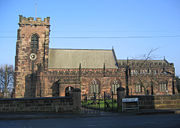 |
Late 12th century | Church Road 53.2905°N 2.7196°W |
||
| 44 High Street | 16th and 17th century | ||||
| 56 Hillside Road | Early 17th century | ||||
| Lower Rileybank Farmhouse | Probably early 17th century | Manley Road | |||
| Ring O'Bells Inn | 17th century | Bellemonte Road 53.2900°N 2.7201°W |
|||
| Millbank Cottages | 17th century | 3, 4 and 5 Main Street | |||
| 47, 49 and 51 Main Street | 17th century | ||||
| 53, 55 and 57 Main Street | 17th century | ||||
| Old Hall Hotel | 17th century | 81 Main Street 53.2952°N 2.7279°W |
|||
| 84 Main Street | 17th century | ||||
| 85 and 89 Main Street | 17th century | ||||
| 90 Main Street | 17th century, refronted early 19th century | ||||
| Queen's Head Hotel | 17th century, refronted probably early 19th century | Main Street | |||
| Bear's Paw Hotel | 1632, restored 1902–03 | Main Street 53.2961°N 2.7259°W |
|||
| Church House Farmhouse | Late 17th century | Church Road | |||
| Stable | Late 17th century | East side of yard behind Queen's Head Hotel, Main Street | |||
| Rock Cottage and Rock Farm | 1680 | Chester Road | |||
| Manor Farm haybarn or shippon | 17th century and later | Bridge Lane | |||
| Five Crosses Farmhouse | c. 1700 | Kingsley Road 53.2824°N 2.7075°W |
|||
| Millbank Farm | 18th century or earlier | Main Street | |||
| Godscroft Hall Farmhouse | Early 18th century | Godscroft Lane 53.2853°N 2.7467°W |
|||
| The Old Vicarage | Early 18th century, altered early 19th century, refaced 1872 | Vicarage Lane 53.2897°N 2.7170°W |
|||
| 1 Church Street | Mid-18th century | 53.2959°N 2.7255°W | |||
| 4 High Street | Mid-18th century | 53.2960°N 2.7253°W | |||
| The Paddocks | Mid-18th century | Manley Road | |||
| Overton House | Mid-18th century | School Lane | |||
| Manor Farm shippon | Late 18th century | Bridge Lane | |||
| 83 Main Street | Late 18th century | ||||
| Shippon | Probably late 18th century | 30 metres east of Rileybank Farmhouse, Manley Road | |||
| Brook Farmhouse | Probably late 18th century | Watery Lane 53.2859°N 2.7007°W |
|||
| Four boundary stones | c. 1770 | South bank of water meadow | |||
| Four boundary stones | 177(?) | North bank of water meadow | |||
| Sundial | 1780 | St Lawrence's Churchyard 53.2903°N 2.7198°W |
|||
| Frodsham Lock and Weir | 1781 | 53.2990°N 2.6961°W | |||
| Frodsham Weir with flood gates | 1785 | 53.3029°N 2.6948°W | |||
| Walls | Georgian | West and north side of garden at Old Hall Hotel 53.2956°N 2.7282°W |
|||
| Two tide stones | 1802 and 1862 | Behind Old Hall Hotel | |||
| Wright tomb | c. 1806 | St Lawrence's Churchyard 53.2904°N 2.7201°W |
|||
| Manor Farm cottage and coachhouse | Early 19th century | Bridge Lane | |||
| Millbank Cottage | Early 19th century | 1–2 Main Street | |||
| 101 and 103 Main Street | Early 19th century | ||||
| 108 and 110 Main Street | Early 19th century | ||||
| 46 and 48 Main Street | Early 19th century | ||||
| 92 Main Street | Early 19th century | ||||
| L-shaped farm building | Probably early 19th century | Southeast of Riley Bank, Manley Road | |||
| The Golden Lion | Late Georgian | Main Street53.2958°N 2.7257°W | |||
| Bradley Hall Farmhouse | c. 1820 | Bradley Lane 53.2885°N 2.7032°W |
|||
| Rock Villa | c. 1830 | 67 High Street | |||
| Brook House | c. 1830 | 38 Main Street | |||
| Ashley House | c. 1830 | 59 Main Street | |||
| Frodsham Viaduct | 1848 | 53.3059°N 2.7014°W | |||
| Frodsham Railway Station Frodsham railway station Frodsham railway station serves the town of Frodsham, Cheshire, England. The station is managed by Arriva Trains Wales. The station building has been designated by English Heritage as a Grade II listed building.... |
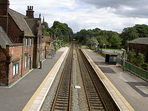 |
1849 | 53.2959°N 2.7237°W | ||
| Frodsham Bridge | 1850 | Sutton Causeway 53.3009°N 2.7067°W |
|||
| Trustees Savings Bank | 1852 | Main Street | |||
| 52 Main Street | Mid-19th century | ||||
| Entry to army premises | Mid-19th century | Adjacent to 52 Main Street | |||
| Folly tower | Probably mid-19th century | Southwest of Fox Hill, Tarvin Road | |||
| Hand pump | Late 19th century | Front of Lower Riley Bank, Manley Road | |||
| War memorial | 1919 | Overton Hill 53.28821°N 2.72505°W |
|||
| Telephone kiosk | 1927 | Church Street 53.295350°N 2.725159°W |
|||
| Telephone kiosk | 1935 | Front of 101 and 103 Main Street | |||