

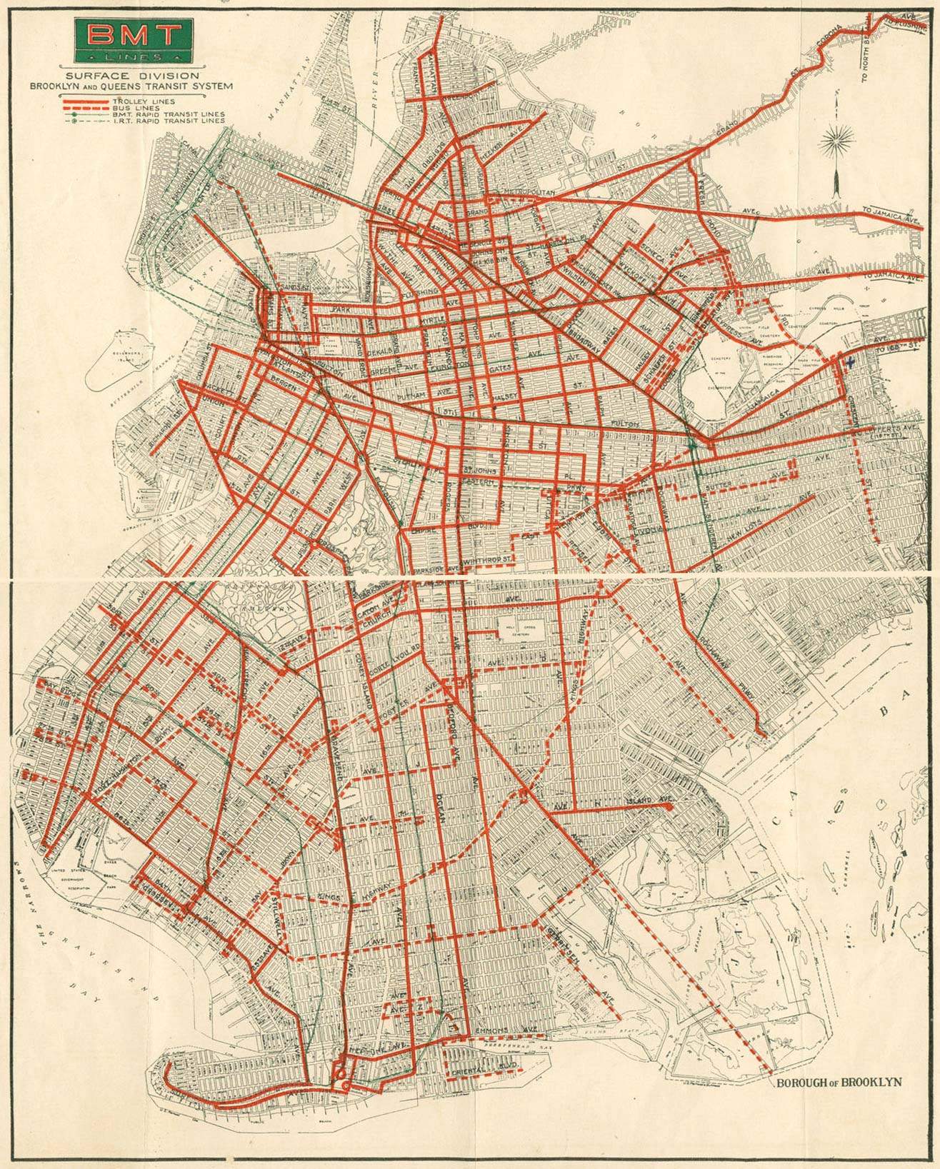
List of streetcar lines in Brooklyn
Encyclopedia
gauge]]
The following streetcar lines once operated in Brooklyn
, New York City
, New York
, United States
.
BRT/BMT subsidiaries
Companies not owned by the BRT/BMT or jointly owned
, a subsidiary of the Brooklyn-Manhattan Transit Corporation
, prior to the takeover of the lines by the New York City Board of Transportation on June 5, 1940. Many of the lines ended at the Brooklyn Bridge
in downtown Brooklyn
or Williamsburg Bridge
in Williamsburg
, with some going over to the Park Row
or Essex Street terminals in Manhattan
. The small number of BMT streetcar lines that operated only in Queens are also included here.
The following streetcar lines once operated in Brooklyn
Brooklyn
Brooklyn is the most populous of New York City's five boroughs, with nearly 2.6 million residents, and the second-largest in area. Since 1896, Brooklyn has had the same boundaries as Kings County, which is now the most populous county in New York State and the second-most densely populated...
, New York City
New York City
New York is the most populous city in the United States and the center of the New York Metropolitan Area, one of the most populous metropolitan areas in the world. New York exerts a significant impact upon global commerce, finance, media, art, fashion, research, technology, education, and...
, New York
New York
New York is a state in the Northeastern region of the United States. It is the nation's third most populous state. New York is bordered by New Jersey and Pennsylvania to the south, and by Connecticut, Massachusetts and Vermont to the east...
, United States
United States
The United States of America is a federal constitutional republic comprising fifty states and a federal district...
.
History
The history of surface line operation in Brooklyn is long and very complicated, and is best presented under one of the following sub-articles which maintain the proper family tree for each of the lines listed below. These subsidiary articles are:BRT/BMT subsidiaries
- Brooklyn and Queens Transit CorporationBrooklyn and Queens Transit CorporationThe Brooklyn and Queens Transit Corporation was a subsidiary of the Brooklyn-Manhattan Transit Corporation that operated streetcars in Brooklyn and Queens, New York City, United States...
, the main company after 1929 - Brooklyn City RailroadBrooklyn City RailroadThe Brooklyn City Railroad was the oldest and one of the largest operators of streetcars in the City of Brooklyn, New York, continuing in that role when Brooklyn became a borough of New York City in 1898....
- Brooklyn Heights RailroadBrooklyn Heights RailroadThe Brooklyn Heights Railroad was a street railway company in the U.S. state of New York. It leased and operated the streetcar lines of the Brooklyn Rapid Transit Company, but started out with the Montague Street Line, a short cable car line connecting the Wall Street Ferry with downtown Brooklyn...
- Brooklyn, Queens County and Suburban RailroadBrooklyn, Queens County and Suburban RailroadThe Brooklyn, Queens County and Suburban Railroad was a street railway company in Brooklyn and Queens, New York, United States. It originated as a horsecar line and was electrified in 1894....
- Coney Island and Brooklyn Railroad
- Coney Island and Gravesend Railway
- Nassau Electric RailroadNassau Electric RailroadThe Nassau Electric Railroad was an electric street railway company in the U.S. state of New York. The company operated throughout the borough of Brooklyn, as well as over the Brooklyn Bridge and Williamsburg Bridge into Manhattan....
Companies not owned by the BRT/BMT or jointly owned
- Brooklyn and North River Railroad
- Bush Terminal Railroad
- Coney Island, Sheepshead Bay and Ocean Avenue Railroad
- Manhattan Bridge Three Cent Line
- Marine Railway
- Maspeth Railroad and Bridge Company
- Van Brunt Street and Erie Basin Railroad
BMT
Almost every surface line in Brooklyn eventually came under control of the Brooklyn and Queens Transit CorporationBrooklyn and Queens Transit Corporation
The Brooklyn and Queens Transit Corporation was a subsidiary of the Brooklyn-Manhattan Transit Corporation that operated streetcars in Brooklyn and Queens, New York City, United States...
, a subsidiary of the Brooklyn-Manhattan Transit Corporation
Brooklyn-Manhattan Transit Corporation
The Brooklyn–Manhattan Transit Corporation was an urban transit holding company, based in Brooklyn, New York City, United States, and incorporated in 1923. The system was sold to the city in 1940 and today, together with the IND subway system, form the B Division of the New York City Subway...
, prior to the takeover of the lines by the New York City Board of Transportation on June 5, 1940. Many of the lines ended at the Brooklyn Bridge
Brooklyn Bridge
The Brooklyn Bridge is one of the oldest suspension bridges in the United States. Completed in 1883, it connects the New York City boroughs of Manhattan and Brooklyn by spanning the East River...
in downtown Brooklyn
Downtown Brooklyn
Downtown Brooklyn is the third largest central business district in New York City , and is located in the northwestern section of the borough of Brooklyn...
or Williamsburg Bridge
Williamsburg Bridge
The Williamsburg Bridge is a suspension bridge in New York City across the East River connecting the Lower East Side of Manhattan at Delancey Street with the Williamsburg neighborhood of Brooklyn at Broadway near the Brooklyn-Queens Expressway...
in Williamsburg
Williamsburg, Brooklyn
Williamsburg is a neighborhood in the New York City borough of Brooklyn, bordering Greenpoint to the north, Bedford-Stuyvesant to the south, Bushwick to the east and the East River to the west. The neighborhood is part of Brooklyn Community Board 1. The neighborhood is served by the NYPD's 90th ...
, with some going over to the Park Row
Park Row (BMT station)
Park Row was a major elevated railway terminal constructed over the New York end of the Brooklyn Bridge, across from New York City Hall in Manhattan that served as the terminal for BMT services operating over the Brooklyn Bridge from the BMT Fulton Street Line, BMT Myrtle Avenue Line and their...
or Essex Street terminals in Manhattan
Manhattan
Manhattan is the oldest and the most densely populated of the five boroughs of New York City. Located primarily on the island of Manhattan at the mouth of the Hudson River, the boundaries of the borough are identical to those of New York County, an original county of the state of New York...
. The small number of BMT streetcar lines that operated only in Queens are also included here.
| Name | From | To | Major streets | Abandoned | Notes |
|---|---|---|---|---|---|
East-west lines |
|||||
| Sea Gate Line | Sea Gate | Sheepshead Bay Sheepshead Bay, Brooklyn Sheepshead Bay is a bay separating the mainland of Brooklyn, New York City from the eastern portion of Coney Island, the latter originally a barrier island but now effectively an extension of the mainland with peninsulas both east and west... |
Surf Avenue, Neptune Avenue, and Emmons Avenue | December 1, 1946 | now the B36 bus |
| Norton's Point Line | Sea Gate | Coney Island Coney Island Coney Island is a peninsula and beach on the Atlantic Ocean in southern Brooklyn, New York, United States. The site was formerly an outer barrier island, but became partially connected to the mainland by landfill.... |
private right-of-way | November 7, 1948 | now the B74 bus |
| Norton's Point Shuttle | Sea Gate | Surf Avenue | September 26, 1935; also ran June 1943 | ||
| 86th Street Line | Bay Ridge | Coney Island Coney Island Coney Island is a peninsula and beach on the Atlantic Ocean in southern Brooklyn, New York, United States. The site was formerly an outer barrier island, but became partially connected to the mainland by landfill.... |
3rd Avenue, 5th Avenue, 86th Street, and Cropsey Avenue | August 12, 1948 | now the B64 bus |
| Bay Ridge Avenue Line | Bay Ridge | Coney Island Coney Island Coney Island is a peninsula and beach on the Atlantic Ocean in southern Brooklyn, New York, United States. The site was formerly an outer barrier island, but became partially connected to the mainland by landfill.... |
3rd Avenue, Bay Ridge Avenue, 13th Avenue, 86th Street, and Cropsey Avenue | May 15, 1949 | now the B1 bus |
| Bergen Beach Line | Flatbush Flatbush, Brooklyn Flatbush is a community of the Borough of Brooklyn, a part of New York City, consisting of several neighborhoods.The name Flatbush is an Anglicization of the Dutch language Vlacke bos .... |
Bergen Beach Bergen Beach, Brooklyn Bergen Beach is a neighborhood in the New York City borough of Brooklyn. The area is part of Brooklyn Community Board 18.What is now Bergen Beach was an island off the coast of Canarsie that was connected to the mainland in the early 1900s using landfill.... |
Flatbush Avenue and Avenue N | August 6, 1930 (east end); March 5, 1951 (whole line) | |
| Cortelyou Road Line | Kensington Kensington, Brooklyn Kensington is a neighborhood in the center of the New York City borough of Brooklyn. It is the area south of Prospect Park and the Green-Wood Cemetery. It is bordered by Coney Island Avenue to the east, Fort Hamilton Parkway and Caton Avenue to the north, McDonald Avenue and 37th Street to the... |
Prospect Park | Cortelyou Road and 16th Avenue | July 23, 1930 | |
| Holy Cross Cemetery Line Holy Cross Cemetery Line The Holy Cross Cemetery Line was a public transit line in Brooklyn, New York City, United States, running as a short branch of the Nostrand Avenue Line east to Holy Cross Cemetery on Tilden Avenue... |
Prospect Park South Prospect Park South, Brooklyn Prospect Park South is a neighborhood in the New York City borough of Brooklyn, within the community of Flatbush. It is bordered by Church Avenue to the north, the Brighton Line of the New York City Subway to the east, Beverley Road to the south, and between Stratford Road and Coney Island Avenue... |
Holy Cross Cemetery Holy Cross Cemetery Holy Cross Cemetery may refer to:*Holy Cross Cemetery, Brooklyn, New York, New York, USA*Holy Cross Cemetery, Colma, California, USA*Holy Cross Cemetery, Culver City, California, USA*Holy Cross Cemetery, Detroit, Michigan, USA... |
Tilden Avenue | April 1, 1951 | |
| Church Avenue Line Church Avenue Line (surface) The Church Avenue Line is a public transit line in Brooklyn, New York City, running mainly along 39th Street and Church Avenue between Sunset Park and Brownsville... |
Greenwood Heights Greenwood Heights, Brooklyn Greenwood Heights is a neighborhood in the New York City borough of Brooklyn that takes part of its name from the neighborhood proximity to the Green-Wood Cemetery... |
Brownsville Brownsville, Brooklyn Brownsville is a residential neighborhood located in eastern Brooklyn, New York City.The total land area is one square mile, and the ZIP code for the neighborhood is 11212.... |
39th Street and Church Avenue | October 31, 1956 | now the B35 bus |
| Gravesend and Church Avenues Line | Kensington Kensington, Brooklyn Kensington is a neighborhood in the center of the New York City borough of Brooklyn. It is the area south of Prospect Park and the Green-Wood Cemetery. It is bordered by Coney Island Avenue to the east, Fort Hamilton Parkway and Caton Avenue to the north, McDonald Avenue and 37th Street to the... |
Brownsville Brownsville, Brooklyn Brownsville is a residential neighborhood located in eastern Brooklyn, New York City.The total land area is one square mile, and the ZIP code for the neighborhood is 11212.... |
Gravesend Avenue (McDonald Avenue) and Church Avenue | June 1, 1949 | |
| New Lots Avenue Line | Brownsville Brownsville, Brooklyn Brownsville is a residential neighborhood located in eastern Brooklyn, New York City.The total land area is one square mile, and the ZIP code for the neighborhood is 11212.... |
New Lots New Lots, Brooklyn New Lots is a sub-section of the East New York neighborhood in the eastern part of the New York City borough of Brooklyn. It was known as the Town of New Lots from 1852 when the area seceded from the Town of Flatbush until it was annexed in 1886 as the 26th Ward of Brooklyn. The population is... |
New Lots Avenue | September 1, 1947 | now the B15 bus |
| Fifteenth Street Line | Red Hook Red Hook, Brooklyn Red Hook is a neighborhood in the New York City borough of Brooklyn, USA. The neighborhood is part of Brooklyn Community Board 6. It is also the location where the transatlantic liner, the , docks in New York City.- History :... |
Windsor Terrace Windsor Terrace, Brooklyn Windsor Terrace is a neighborhood in the New York City borough of Brooklyn. It is bounded by Prospect Park to the northeast and Green-Wood Cemetery, a National Historic Landmark, to the southwest. Its southeastern boundary is Caton Avenue, while to the northwest it is bordered by Prospect Park West... |
Hamilton Avenue and 15th Street | December 1, 1945 | |
| Union Street Line | Red Hook Red Hook, Brooklyn Red Hook is a neighborhood in the New York City borough of Brooklyn, USA. The neighborhood is part of Brooklyn Community Board 6. It is also the location where the transatlantic liner, the , docks in New York City.- History :... |
Windsor Terrace Windsor Terrace, Brooklyn Windsor Terrace is a neighborhood in the New York City borough of Brooklyn. It is bounded by Prospect Park to the northeast and Green-Wood Cemetery, a National Historic Landmark, to the southwest. Its southeastern boundary is Caton Avenue, while to the northwest it is bordered by Prospect Park West... |
Union Street and Prospect Park West | December 1, 1945 | |
| St. Johns Place Line St. Johns Place Line The St. Johns Place Line is a public transit line in Brooklyn, New York, mainly along Atlantic Avenue, Washington Avenue, Sterling Place, and St. Johns Place between Downtown Brooklyn and Crown Heights... |
Downtown | Brownsville Brownsville, Brooklyn Brownsville is a residential neighborhood located in eastern Brooklyn, New York City.The total land area is one square mile, and the ZIP code for the neighborhood is 11212.... |
Atlantic Avenue, Sterling Place, St. Johns Place, and Rockaway Avenue | August 24, 1947 | now the B45 bus |
| Bergen Street Line Bergen Street Line The Bergen Street Line is a public transit line in Brooklyn, New York City, United States, running westbound mostly along Bergen Street, as well as eastbound on Dean Street , between downtown Brooklyn and Ocean Hill... |
Red Hook Red Hook, Brooklyn Red Hook is a neighborhood in the New York City borough of Brooklyn, USA. The neighborhood is part of Brooklyn Community Board 6. It is also the location where the transatlantic liner, the , docks in New York City.- History :... |
Ozone Park, Queens Ozone Park, Queens Ozone Park is a working class neighborhood located in the southwestern section of the New York City borough of Queens bordering Woodhaven, Richmond Hill, South Ozone Park, Howard Beach, and City Line, Brooklyn.... |
Sackett Street, Bergen Street, and Liberty Avenue | July 20, 1947 | now the B65 bus |
| Fulton Street Line Fulton Street Line (Brooklyn surface) The Fulton Street Line or East New York Line is a public transit line in Brooklyn, New York City, United States along Fulton Street between Fulton Ferry and East New York... |
Downtown | East New York East New York, Brooklyn East New York is a residential neighborhood located in the Eastern section of the borough of Brooklyn in New York City, United States. The neighborhood is part of Brooklyn Community Board 5... |
Fulton Street | August 10, 1941 | now the B25 bus |
| Putnam Avenue Line Putnam Avenue Line The Putnam Avenue Line is a public transit line in Brooklyn, New York City, United States, running mostly along Fulton Street, Putnam Avenue, and Halsey Street between downtown Brooklyn and Ridgewood, Queens... |
Downtown | Ridgewood, Queens Ridgewood, Queens Ridgewood is a neighborhood in the New York City borough of Queens. It borders the neighborhoods of Maspeth, Middle Village and Glendale, as well as the Brooklyn neighborhood of Bushwick. Historically, the neighborhood straddled the Queens-Brooklyn boundary. The neighborhood is part of Queens... |
Fulton Street, Putnam Avenue, and Halsey Street | September 21, 1941; restored November 29, 1942 to February 5, 1950 | now the B26 bus |
| Greene and Gates Avenues Line Greene and Gates Avenues Line The Greene and Gates Avenues Line is a public transit line in Brooklyn, New York City, United States, running mostly along Fulton Street, Greene Avenue, and Gates Avenue between Downtown Brooklyn and Ridgewood, Queens... |
Downtown | Ridgewood, Queens Ridgewood, Queens Ridgewood is a neighborhood in the New York City borough of Queens. It borders the neighborhoods of Maspeth, Middle Village and Glendale, as well as the Brooklyn neighborhood of Bushwick. Historically, the neighborhood straddled the Queens-Brooklyn boundary. The neighborhood is part of Queens... |
Fulton Street, Greene Avenue, and Gates Avenue | October 5, 1941 | now the B52 bus |
| DeKalb Avenue Line DeKalb Avenue Line The DeKalb Avenue Line is a public transit line in Brooklyn and Queens, New York City, United States, running mostly along DeKalb Avenue, as well as eastbound on Lafayette Avenue , between downtown Brooklyn and Ridgewood, Queens... |
Brooklyn Bridge | Ridgewood, Queens Ridgewood, Queens Ridgewood is a neighborhood in the New York City borough of Queens. It borders the neighborhoods of Maspeth, Middle Village and Glendale, as well as the Brooklyn neighborhood of Bushwick. Historically, the neighborhood straddled the Queens-Brooklyn boundary. The neighborhood is part of Queens... |
DeKalb Avenue and Seneca Avenue | January 30, 1949 | now the B38 bus |
| Montague Street Line | Downtown | Montague Street | |||
| Myrtle Avenue and Court Street Line | Red Hook Red Hook, Brooklyn Red Hook is a neighborhood in the New York City borough of Brooklyn, USA. The neighborhood is part of Brooklyn Community Board 6. It is also the location where the transatlantic liner, the , docks in New York City.- History :... |
Ridgewood, Queens Ridgewood, Queens Ridgewood is a neighborhood in the New York City borough of Queens. It borders the neighborhoods of Maspeth, Middle Village and Glendale, as well as the Brooklyn neighborhood of Bushwick. Historically, the neighborhood straddled the Queens-Brooklyn boundary. The neighborhood is part of Queens... |
Court Street and Myrtle Avenue | July 17, 1949 | now the B54 and B57 buses |
| Park Avenue Line | Brooklyn Bridge | Trinity Cemetery | Park Avenue and Wilson Avenue | June 19, 1930 | |
| Flushing Avenue Line | Brooklyn Bridge | Maspeth, Queens Maspeth, Queens Maspeth is a small community in the borough of Queens in New York City. Neighborhoods sharing borders with Maspeth are Woodside and Sunnyside to the north, Long Island City to the northwest, Greenpoint to the west, East Williamsburg to the southwest, Fresh Pond and Ridgewood to the south, and... |
Flushing Avenue | November 21, 1948 | now the B57 bus |
| Broadway Line Broadway Line (Brooklyn surface) The Broadway Line was a public transit line in Brooklyn, New York City, United States along Broadway between Williamsburg and East New York. Originally a streetcar line, it later became a bus route, but no bus currently operates over the entire length of Broadway, with the BMT Jamaica Line... |
Williamsburg Bridge | Cypress Hills Cypress Hills, Brooklyn Cypress Hills is a sub-section of the East New York neighborhood in Brooklyn, New York City, lying north of City Line and south of Cypress Hills Cemetery, in the far northeastern corner of Brooklyn. It is abutted on the west by Bushwick and on the east, across the Brooklyn–Queens border, by... |
Broadway and Fulton Street | January 15, 1950 | now the Q24 bus |
| Williamsburg Bridge Local | Williamsburg Bridge | Williamsburg Bridge | December 4, 1948 | ||
| Jamaica Line | Ocean Hill Ocean Hill, Brooklyn Ocean Hill is a subsection of Bedford-Stuyvesant in the New York City borough of Brooklyn. Founded in 1890, the neighborhood is part of Brooklyn Community Board 3 and Brooklyn Community Board 16. The ZIP code for the neighborhood is 11233... |
Jamaica, Queens Jamaica, Queens Jamaica is a neighborhood in the borough of Queens in New York City, New York, United States. It was settled under Dutch rule in 1656 in New Netherland as Rustdorp. Under British rule, the Village of Jamaica became the center of the "Town of Jamaica"... |
Fulton Street and Jamaica Avenue | November 30, 1947 | now the Q56 bus |
| Bushwick Avenue Line Bushwick Avenue Line The Bushwick Avenue Line or Bushwick Line was a public transit line in Brooklyn, New York City, United States, running mostly along Bushwick Avenue and Myrtle Avenue between Williamsburg and Ridgewood, Queens.-History:... |
Williamsburg Bridge | Ridgewood, Queens Ridgewood, Queens Ridgewood is a neighborhood in the New York City borough of Queens. It borders the neighborhoods of Maspeth, Middle Village and Glendale, as well as the Brooklyn neighborhood of Bushwick. Historically, the neighborhood straddled the Queens-Brooklyn boundary. The neighborhood is part of Queens... |
Meserole Street, Bushwick Avenue, and Myrtle Avenue | September 1, 1947 | |
| Wilson Avenue Line Wilson Avenue Line The Wilson Avenue Line is a public transit line in Brooklyn, New York City, United States, running along Wilson Avenue and Rockaway Avenue between Williamsburg and Canarsie... |
Williamsburg Bridge | Canarsie Canarsie, Brooklyn Canarsie is a neighborhood in the southeastern portion of the borough of Brooklyn, in New York City, United States. The area is part of Brooklyn Community Board 18.... |
Johnson Avenue, Wilson Avenue, and Rockaway Avenue | May 27, 1951 | now the B60 bus |
| Cypress Hills Cemetery Line | Ridgewood, Queens Ridgewood, Queens Ridgewood is a neighborhood in the New York City borough of Queens. It borders the neighborhoods of Maspeth, Middle Village and Glendale, as well as the Brooklyn neighborhood of Bushwick. Historically, the neighborhood straddled the Queens-Brooklyn boundary. The neighborhood is part of Queens... |
Cypress Hills Cemetery, Queens | Cypress Avenue | September 1, 1947 | |
| Richmond Hill Line Richmond Hill Line The Richmond Hill Line is a surface transit line on Myrtle Avenue in Queens, New York City, United States. Once a streetcar line owned by the Brooklyn–Manhattan Transit Corporation, it is now the Q55 Myrtle Avenue bus route, operated by the New York City Transit Authority.... |
Ridgewood, Queens Ridgewood, Queens Ridgewood is a neighborhood in the New York City borough of Queens. It borders the neighborhoods of Maspeth, Middle Village and Glendale, as well as the Brooklyn neighborhood of Bushwick. Historically, the neighborhood straddled the Queens-Brooklyn boundary. The neighborhood is part of Queens... |
Jamaica, Queens Jamaica, Queens Jamaica is a neighborhood in the borough of Queens in New York City, New York, United States. It was settled under Dutch rule in 1656 in New Netherland as Rustdorp. Under British rule, the Village of Jamaica became the center of the "Town of Jamaica"... |
Myrtle Avenue | April 26, 1950 | now the Q55 bus |
| Metropolitan Avenue Line | Williamsburg Bridge | Jamaica, Queens Jamaica, Queens Jamaica is a neighborhood in the borough of Queens in New York City, New York, United States. It was settled under Dutch rule in 1656 in New Netherland as Rustdorp. Under British rule, the Village of Jamaica became the center of the "Town of Jamaica"... |
Grand Street and Metropolitan Avenue | June 12, 1949 | now the Q54 bus |
| Metropolitan Avenue Shuttle | Williamsburg Williamsburg, Brooklyn Williamsburg is a neighborhood in the New York City borough of Brooklyn, bordering Greenpoint to the north, Bedford-Stuyvesant to the south, Bushwick to the east and the East River to the west. The neighborhood is part of Brooklyn Community Board 1. The neighborhood is served by the NYPD's 90th ... |
East Williamsburg East Williamsburg, Brooklyn East Williamsburg is a name for the area in the northwestern portion of the borough of Brooklyn in New York City, United States, which lies between Williamsburg, Greenpoint, and Bushwick. Much of this area has been and still is referred to as either Bushwick, Williamsburg, or Greenpoint with the... |
Metropolitan Avenue | 1920 | |
| Flushing-Ridgewood Line | Ridgewood, Queens Ridgewood, Queens Ridgewood is a neighborhood in the New York City borough of Queens. It borders the neighborhoods of Maspeth, Middle Village and Glendale, as well as the Brooklyn neighborhood of Bushwick. Historically, the neighborhood straddled the Queens-Brooklyn boundary. The neighborhood is part of Queens... |
Flushing, Queens Flushing, Queens Flushing, founded in 1645, is a neighborhood in the north central part of the City of New York borough of Queens, east of Manhattan.Flushing was one of the first Dutch settlements on Long Island. Today, it is one of the largest and most diverse neighborhoods in New York City... |
Fresh Pond Road, Grand Avenue, and Corona Avenue | July 17, 1949 | now the Q58 bus |
| Grand Street Line Grand Street Line (Brooklyn) The Grand Street Line is a public transit line in Brooklyn and Queens, New York City, United States, running mostly along Grand Street/Grand Avenue between Williamsburg, Brooklyn and Maspeth, Queens... |
Williamsburg Williamsburg, Brooklyn Williamsburg is a neighborhood in the New York City borough of Brooklyn, bordering Greenpoint to the north, Bedford-Stuyvesant to the south, Bushwick to the east and the East River to the west. The neighborhood is part of Brooklyn Community Board 1. The neighborhood is served by the NYPD's 90th ... |
Maspeth, Queens Maspeth, Queens Maspeth is a small community in the borough of Queens in New York City. Neighborhoods sharing borders with Maspeth are Woodside and Sunnyside to the north, Long Island City to the northwest, Greenpoint to the west, East Williamsburg to the southwest, Fresh Pond and Ridgewood to the south, and... |
Grand Street and Grand Avenue | December 11, 1949 | now the Q59 bus |
| Calvary Cemetery Line | Greenpoint Greenpoint, Brooklyn Greenpoint is the northernmost neighborhood in the New York City borough of Brooklyn. It is bordered on the southwest by Williamsburg at the Bushwick inlet, on the southeast by the Brooklyn-Queens Expressway and East Williamsburg, on the north by Newtown Creek and Long Island City, Queens at the... |
Calvary Cemetery, Queens Calvary Cemetery, Queens The Roman Catholic Calvary Cemetery in Queens has the largest number of interments of any cemetery in the United States.The offices of Calvary Cemetery are located at 49-02 Laurel Hill Blvd. in Woodside in the New York City borough of Queens, New York. The cemetery is managed by the Trustees of... |
Greenpoint Avenue | January 26, 1930 | now the B24 bus |
North-south lines |
|||||
| Furman Street Line Furman Street Line The Furman Street Line was a street railway line in Brooklyn, New York City, United States, running along Furman Street from Cobble Hill to Fulton Ferry.-History:... |
Red Hook Red Hook, Brooklyn Red Hook is a neighborhood in the New York City borough of Brooklyn, USA. The neighborhood is part of Brooklyn Community Board 6. It is also the location where the transatlantic liner, the , docks in New York City.- History :... |
Downtown | Columbia Street and Furman Street | ||
| Hicks Street Line Hicks Street Line The Hicks Street Line was a public transit line in Brooklyn, New York City, United States, running from the Ninth Avenue Depot at Greenwood Cemetery to the Brooklyn Bridge.-History:... |
Red Hook Red Hook, Brooklyn Red Hook is a neighborhood in the New York City borough of Brooklyn, USA. The neighborhood is part of Brooklyn Community Board 6. It is also the location where the transatlantic liner, the , docks in New York City.- History :... |
Cobble Hill Cobble Hill, Brooklyn Cobble Hill is a neighborhood in the New York City borough of Brooklyn, USA. Bordered by Atlantic Avenue on the north, Hicks Street to the west, Smith Street on the east and Degraw Street to the south, Cobble Hill sits adjacent to Boerum Hill and Brooklyn Heights with Carroll Gardens to the south... |
Hicks Street | 1921 | |
| Erie Basin Line | Red Hook Red Hook, Brooklyn Red Hook is a neighborhood in the New York City borough of Brooklyn, USA. The neighborhood is part of Brooklyn Community Board 6. It is also the location where the transatlantic liner, the , docks in New York City.- History :... |
Brooklyn Bridge | Columbia Street | March 5, 1944 | now the B61 bus |
| Crosstown Line Crosstown Line (Brooklyn surface) The Crosstown Line is a public transit line in Brooklyn, New York City, United States, running along Van Brunt Street and Manhattan Avenue between Red Hook and Long Island City, Queens. Originally a streetcar line, it is now the B61 and the B62 bus routes... |
Red Hook Red Hook, Brooklyn Red Hook is a neighborhood in the New York City borough of Brooklyn, USA. The neighborhood is part of Brooklyn Community Board 6. It is also the location where the transatlantic liner, the , docks in New York City.- History :... |
Greenpoint Greenpoint, Brooklyn Greenpoint is the northernmost neighborhood in the New York City borough of Brooklyn. It is bordered on the southwest by Williamsburg at the Bushwick inlet, on the southeast by the Brooklyn-Queens Expressway and East Williamsburg, on the north by Newtown Creek and Long Island City, Queens at the... |
Columbia Street, Flushing Avenue, Wythe Avenue, Driggs Avenue, Bedford Avenue, and Manhattan Avenue | January 27, 1951 | now the B61 bus |
| 65th Street-Fort Hamilton Line | Fort Hamilton Fort Hamilton, Brooklyn Fort Hamilton is a neighborhood in the far southwestern corner of the New York City borough of Brooklyn. It is located south of, and often considered part of, Bay Ridge. The area stretches from 86th Street as its northern border to 101st Street/the Narrows at the south; it is bounded by New York... |
Greenwood Heights Greenwood Heights, Brooklyn Greenwood Heights is a neighborhood in the New York City borough of Brooklyn that takes part of its name from the neighborhood proximity to the Green-Wood Cemetery... |
3rd Avenue and 2nd Avenue | March 1, 1942 | |
| Hamilton Avenue Line Hamilton Avenue Line The Hamilton Avenue Line was a public transit line in Brooklyn, New York City, United States, running mostly along Hamilton Avenue between Bay Ridge and Hamilton Ferry at the north end of the avenue in Red Hook... |
Bay Ridge | Red Hook Red Hook, Brooklyn Red Hook is a neighborhood in the New York City borough of Brooklyn, USA. The neighborhood is part of Brooklyn Community Board 6. It is also the location where the transatlantic liner, the , docks in New York City.- History :... |
3rd Avenue and Hamilton Avenue | March 29, 1942 | |
| Smith Street Line Smith Street Line (surface) The Smith Street Line was a public transit line in Brooklyn, New York City, United States, running mostly along Ninth Street and Smith Street between Park Slope and Downtown Brooklyn. Originally a streetcar line, and later the B75, it is now split between the B57 and B61 bus routes... |
Windsor Terrace Windsor Terrace, Brooklyn Windsor Terrace is a neighborhood in the New York City borough of Brooklyn. It is bounded by Prospect Park to the northeast and Green-Wood Cemetery, a National Historic Landmark, to the southwest. Its southeastern boundary is Caton Avenue, while to the northwest it is bordered by Prospect Park West... |
Brooklyn Bridge | 9th Street and Smith Street | February 11, 1951 | now the B57 bus |
| Third Avenue Line | Fort Hamilton Fort Hamilton, Brooklyn Fort Hamilton is a neighborhood in the far southwestern corner of the New York City borough of Brooklyn. It is located south of, and often considered part of, Bay Ridge. The area stretches from 86th Street as its northern border to 101st Street/the Narrows at the south; it is bounded by New York... |
Brooklyn Bridge | 3rd Avenue | March 1, 1942 | |
| Fifth Avenue Line Fifth Avenue Line (Brooklyn surface) The Fifth Avenue Line is a public transit line in Brooklyn, New York City, United States, running mainly along Fifth Avenue and Atlantic Avenue between Fort Hamilton and Cobble Hill... |
Fort Hamilton Fort Hamilton, Brooklyn Fort Hamilton is a neighborhood in the far southwestern corner of the New York City borough of Brooklyn. It is located south of, and often considered part of, Bay Ridge. The area stretches from 86th Street as its northern border to 101st Street/the Narrows at the south; it is bounded by New York... |
Cobble Hill Cobble Hill, Brooklyn Cobble Hill is a neighborhood in the New York City borough of Brooklyn, USA. Bordered by Atlantic Avenue on the north, Hicks Street to the west, Smith Street on the east and Degraw Street to the south, Cobble Hill sits adjacent to Boerum Hill and Brooklyn Heights with Carroll Gardens to the south... |
5th Avenue and Atlantic Avenue | February 20, 1949 | now the B63 bus |
| Seventh Avenue Line | Windsor Terrace Windsor Terrace, Brooklyn Windsor Terrace is a neighborhood in the New York City borough of Brooklyn. It is bounded by Prospect Park to the northeast and Green-Wood Cemetery, a National Historic Landmark, to the southwest. Its southeastern boundary is Caton Avenue, while to the northwest it is bordered by Prospect Park West... |
Brooklyn Bridge | 7th Avenue and Flatbush Avenue | February 11, 1951 | now the B67 bus |
| Eighth Avenue Line | Bay Ridge Bay Ridge, Brooklyn Bay Ridge is a neighborhood in the southwest corner of the New York City borough of Brooklyn, USA. It is bounded by Sunset Park on the north, Seventh Avenue and Dyker Heights on the east, The Narrows Strait, which partially houses the Belt Parkway, on the west and 86th Street and Fort Hamilton on... |
Greenwood Heights Greenwood Heights, Brooklyn Greenwood Heights is a neighborhood in the New York City borough of Brooklyn that takes part of its name from the neighborhood proximity to the Green-Wood Cemetery... |
8th Avenue and 39th Street | May 15, 1949 | |
| West End Line West End Line (Brooklyn surface) The West End Line or New Utrecht Avenue Line was a surface transit line in Brooklyn, New York City, United States, running along New Utrecht Avenue and other streets between Coney Island and Sunset Park... |
Coney Island Coney Island Coney Island is a peninsula and beach on the Atlantic Ocean in southern Brooklyn, New York, United States. The site was formerly an outer barrier island, but became partially connected to the mainland by landfill.... |
Sunset Park Sunset Park, Brooklyn Sunset Park is a neighborhood in the western section of the New York City borough of Brooklyn, USA. It is bounded by Greenwood Heights to the north, Borough Park to the east, Bay Ridge to the south, and Upper New York Bay to the west... |
New Utrecht Avenue | June 28, 1947 | |
| Sixteenth Avenue Line | New Utrecht New Utrecht, Brooklyn New Utrecht was the last of six towns to be founded in what is today the borough of Brooklyn in New York City. It was named after the city of Utrecht, Netherlands. In 1652 Cornelius van Werckhoven, a surveyor born in Utrecht and a principal investor in the Dutch West India Company, began purchasing... |
Kensington Kensington, Brooklyn Kensington is a neighborhood in the center of the New York City borough of Brooklyn. It is the area south of Prospect Park and the Green-Wood Cemetery. It is bordered by Coney Island Avenue to the east, Fort Hamilton Parkway and Caton Avenue to the north, McDonald Avenue and 37th Street to the... |
16th Avenue and Cortelyou Road | January 26, 1930 | |
| McDonald Avenue Line | Coney Island Coney Island Coney Island is a peninsula and beach on the Atlantic Ocean in southern Brooklyn, New York, United States. The site was formerly an outer barrier island, but became partially connected to the mainland by landfill.... |
Windsor Terrace Windsor Terrace, Brooklyn Windsor Terrace is a neighborhood in the New York City borough of Brooklyn. It is bounded by Prospect Park to the northeast and Green-Wood Cemetery, a National Historic Landmark, to the southwest. Its southeastern boundary is Caton Avenue, while to the northwest it is bordered by Prospect Park West... |
McDonald Avenue | October 31, 1956 | |
| Coney Island Avenue Line | Coney Island Coney Island Coney Island is a peninsula and beach on the Atlantic Ocean in southern Brooklyn, New York, United States. The site was formerly an outer barrier island, but became partially connected to the mainland by landfill.... |
Windsor Terrace Windsor Terrace, Brooklyn Windsor Terrace is a neighborhood in the New York City borough of Brooklyn. It is bounded by Prospect Park to the northeast and Green-Wood Cemetery, a National Historic Landmark, to the southwest. Its southeastern boundary is Caton Avenue, while to the northwest it is bordered by Prospect Park West... |
Coney Island Avenue | November 30, 1955 | now the B68 bus |
| Greenpoint Line Greenpoint Line The Greenpoint Line was a streetcar line in Brooklyn, New York City, United States. When it stopped operating, it was not replaced by a bus route.-History:The line was opened by the Brooklyn City Railroad in October 1854 to Bushwick Creek.... |
Downtown | Greenpoint Greenpoint, Brooklyn Greenpoint is the northernmost neighborhood in the New York City borough of Brooklyn. It is bordered on the southwest by Williamsburg at the Bushwick inlet, on the southeast by the Brooklyn-Queens Expressway and East Williamsburg, on the north by Newtown Creek and Long Island City, Queens at the... |
Myrtle Avenue, Kent Avenue, and Franklin Street | November 19, 1945 | |
| Flatbush Avenue Line Flatbush Avenue Line (surface) The Flatbush Avenue Line is a public transit line in Brooklyn, New York City, United States, running along Flatbush Avenue between Downtown Brooklyn and Marine Park... |
Marine Park Marine Park, Brooklyn Marine Park is a public park located in the borough of Brooklyn in New York City. Its 798 acres surround the westernmost inlet of Jamaica Bay. Most of the land for Marine Park, Brooklyn was donated to New York City to be turned into public park land by the Whitney family in 1920 and by Frederic B.... |
Downtown | Flatbush Avenue | March 5, 1951 | now the B41 bus |
| Vanderbilt Avenue Line Vanderbilt Avenue Line The Vanderbilt Avenue Line is a public transit line in Brooklyn, New York City, running along 7th Avenue and Vanderbilt Avenue between Kensington and Dumbo... |
Windsor Terrace Windsor Terrace, Brooklyn Windsor Terrace is a neighborhood in the New York City borough of Brooklyn. It is bounded by Prospect Park to the northeast and Green-Wood Cemetery, a National Historic Landmark, to the southwest. Its southeastern boundary is Caton Avenue, while to the northwest it is bordered by Prospect Park West... |
Downtown | Vanderbilt Avenue and Flushing Avenue | August 20, 1950 | now the B69 bus |
| Franklin Avenue Line | Prospect Park South Prospect Park South, Brooklyn Prospect Park South is a neighborhood in the New York City borough of Brooklyn, within the community of Flatbush. It is bordered by Church Avenue to the north, the Brighton Line of the New York City Subway to the east, Beverley Road to the south, and between Stratford Road and Coney Island Avenue... |
Williamsburg Bridge | Franklin Avenue and Wythe Avenue | October 28, 1945 | now the B48 bus |
| Ocean Avenue Line | Sheepshead Bay Sheepshead Bay, Brooklyn Sheepshead Bay is a bay separating the mainland of Brooklyn, New York City from the eastern portion of Coney Island, the latter originally a barrier island but now effectively an extension of the mainland with peninsulas both east and west... |
Crown Heights Crown Heights, Brooklyn Crown Heights is a neighborhood in the central portion of the New York City borough of Brooklyn. The main thoroughfare through this neighborhood is Eastern Parkway, a tree-lined boulevard designed by Frederick Law Olmsted extending two miles east-west.Originally, the area was known as Crow Hill.... |
Ocean Avenue and Rogers Avenue | April 29, 1951 | now the B49 bus |
| Nostrand Avenue Line Nostrand Avenue Line (surface) The Nostrand Avenue Line is a public transit line in Brooklyn, New York City, United States, running mostly along Nostrand Avenue, as well as northbound on New York Avenue and Bedford Avenue , between Sheepshead Bay and Williamsburg... |
Sheepshead Bay Sheepshead Bay, Brooklyn Sheepshead Bay is a bay separating the mainland of Brooklyn, New York City from the eastern portion of Coney Island, the latter originally a barrier island but now effectively an extension of the mainland with peninsulas both east and west... |
Williamsburg Bridge | Nostrand Avenue and Lee Avenue | April 1, 1951 | now the B44 bus |
| Meeker and Marcy Avenues Line Meeker and Marcy Avenues Line The Meeker and Marcy Avenues Line was a public transit line in Brooklyn, New York City, United States, running along Marcy Avenue, Metropolitan Avenue, Graham Avenue, and Meeker Avenue from Fulton Street in Bedford-Stuyvesant to Penny Bridge in Williamsburg.... |
Stuyvesant Heights Stuyvesant Heights, Brooklyn Stuyvesant Heights is a neighborhood in north-central Brooklyn, a part of settled in the mid-17th century before the borough of Brooklyn was incorporated as a city... |
Greenpoint Greenpoint, Brooklyn Greenpoint is the northernmost neighborhood in the New York City borough of Brooklyn. It is bordered on the southwest by Williamsburg at the Bushwick inlet, on the southeast by the Brooklyn-Queens Expressway and East Williamsburg, on the north by Newtown Creek and Long Island City, Queens at the... |
Marcy Avenue and Meeker Avenue | April 17, 1939 | now the B24 bus |
| Tompkins Avenue Line | Prospect Park | Williamsburg Bridge | Empire Boulevard, Kingston Avenue, and Tompkins Avenue | August 24, 1947 | now the B43 bus |
| Union Avenue Line Union Avenue Line (Brooklyn) The Union Avenue Line was a public transit line in Brooklyn, New York City, United States, running mostly along Myrtle Avenue, Knickerbocker Avenue, Flushing Avenue, Throop Avenue, and Union Avenue from Ridgewood, Queens northwest to Greenpoint, Brooklyn.... |
Ridgewood, Queens Ridgewood, Queens Ridgewood is a neighborhood in the New York City borough of Queens. It borders the neighborhoods of Maspeth, Middle Village and Glendale, as well as the Brooklyn neighborhood of Bushwick. Historically, the neighborhood straddled the Queens-Brooklyn boundary. The neighborhood is part of Queens... |
Greenpoint Greenpoint, Brooklyn Greenpoint is the northernmost neighborhood in the New York City borough of Brooklyn. It is bordered on the southwest by Williamsburg at the Bushwick inlet, on the southeast by the Brooklyn-Queens Expressway and East Williamsburg, on the north by Newtown Creek and Long Island City, Queens at the... |
Knickerbocker Avenue, Flushing Avenue, and Union Avenue | December 1, 1945 | |
| Lorimer Street Line Lorimer Street Line The Lorimer Street Line is a public transit line in Brooklyn, New York City, United States, running along Lorimer Street, Franklin Avenue, and Classon Avenue between Bedford–Stuyvesant and Greenpoint... |
Prospect Park South Prospect Park South, Brooklyn Prospect Park South is a neighborhood in the New York City borough of Brooklyn, within the community of Flatbush. It is bordered by Church Avenue to the north, the Brighton Line of the New York City Subway to the east, Beverley Road to the south, and between Stratford Road and Coney Island Avenue... |
Greenpoint Greenpoint, Brooklyn Greenpoint is the northernmost neighborhood in the New York City borough of Brooklyn. It is bordered on the southwest by Williamsburg at the Bushwick inlet, on the southeast by the Brooklyn-Queens Expressway and East Williamsburg, on the north by Newtown Creek and Long Island City, Queens at the... |
Franklin Avenue, Lorimer Street, and Nassau Avenue | December 14, 1947 | now the B48 bus |
| Graham Avenue Line | Brooklyn Bridge | Hunters Point, Queens Hunters Point, Queens Hunters Point is a neighborhood on the south side of Long Island City, in the New York City borough of Queens. The neighborhood is part of Queens Community Board 2.- History :... |
Flushing Avenue, Graham Avenue, and Manhattan Avenue | December 21, 1948 | now the B43 bus |
| Sumner Avenue Line | Brownsville Brownsville, Brooklyn Brownsville is a residential neighborhood located in eastern Brooklyn, New York City.The total land area is one square mile, and the ZIP code for the neighborhood is 11212.... |
Williamsburg Bridge | 98th Street, Sumner Avenue (Marcus Garvey Boulevard), and Broadway | July 20, 1947 | now the B15 bus |
| Utica and Reid Avenues Line | Flatlands Flatlands, Brooklyn Flatlands is a neighborhood in the New York City borough of Brooklyn. The area is part of Brooklyn Community Board 18.One of the original five Dutch towns on Long Island , this neighborhood was originally known as Nieuw Amersfoort, after the Dutch city of Amersfoort, but the name was changed to... |
Williamsburg Bridge | Utica Avenue, Reid Avenue, and Broadway | March 18, 1951 | now the B46 bus |
| Ralph Avenue Line Ralph Avenue Line The Ralph Avenue Line is a surface transit line on Ralph Avenue in Brooklyn, New York City, United States. Once a streetcar line, it is now part of the B47 bus route, operated by the New York City Transit Authority, and prior to 1995, it was the B78 route; the northern part of the route was part of... |
Brownsville Brownsville, Brooklyn Brownsville is a residential neighborhood located in eastern Brooklyn, New York City.The total land area is one square mile, and the ZIP code for the neighborhood is 11212.... |
Williamsburg Bridge | 98th Street, Ralph Avenue, and Broadway | November 1, 1943 | now the B47 bus |
| Ralph and Rockaway Avenues Line | Brownsville Brownsville, Brooklyn Brownsville is a residential neighborhood located in eastern Brooklyn, New York City.The total land area is one square mile, and the ZIP code for the neighborhood is 11212.... |
Williamsburg Bridge | Rockaway Avenue, Ralph Avenue, and Broadway | May 27, 1951 | now the B47 bus |
| Rockaway Parkway Line Rockaway Parkway Line The Rockaway Parkway Line is a public transit line in Brooklyn, New York City, United States, running mostly along Rockaway Parkway between Canarsie Pier and the Canarsie – Rockaway Parkway terminal of the BMT Canarsie Line of the New York City Subway... |
Canarsie Landing | Canarsie Canarsie, Brooklyn Canarsie is a neighborhood in the southeastern portion of the borough of Brooklyn, in New York City, United States. The area is part of Brooklyn Community Board 18.... |
Rockaway Parkway | April 29, 1951 | now the B42 bus |
| North Beach Line | Elmhurst, Queens Elmhurst, Queens Elmhurst is a neighborhood in the New York City borough of Queens. It is bounded by Roosevelt Avenue on the north; Corona to the northeast; Junction Boulevard on the east; Rego Park to the southeast; the Long Island Expressway on the south; Middle Village to the south and southwest; and Maspeth... |
North Beach, Queens | Junction Boulevard | August 24, 1949 | now the Q72 bus |
Other companies
| Name | From | To | Major streets | Abandoned | Notes |
|---|---|---|---|---|
| Manhattan Bridge Three Cent Line | Downtown Brooklyn Downtown Brooklyn Downtown Brooklyn is the third largest central business district in New York City , and is located in the northwestern section of the borough of Brooklyn... |
Chinatown, Manhattan Chinatown, Manhattan Manhattan's Chinatown , home to one of the highest concentrations of Chinese people in the Western hemisphere, is located in the borough of Manhattan in New York City... |
Manhattan Bridge Manhattan Bridge The Manhattan Bridge is a suspension bridge that crosses the East River in New York City, connecting Lower Manhattan with Brooklyn . It was the last of the three suspension bridges built across the lower East River, following the Brooklyn and the Williamsburg bridges... |
|
| Hudson Avenue Line Hudson Avenue Line (surface) The Hudson Avenue Line was a horse car street railway line in Brooklyn, New York City, United States, running mostly along Hudson Avenue near Downtown Brooklyn... |
Prospect Park | Downtown | Flatbush Avenue and Hudson Avenue | 1871 |
See also
- Trolley dodgerTrolley dodgerTrolley dodger was a pejorative term of Manhattanites for residents of Brooklyn, New York from the late 19th century to the middle of the 20th century. The term, relating to Brooklyn's preponderance of trolley lines, was the basis for the name of the Major League Baseball team the Brooklyn Dodgers...
- List of streetcar lines in the Bronx
- List of streetcar lines in Manhattan
- List of streetcar lines in Queens
- List of streetcar lines in Staten Island
- List of streetcar lines on Long Island
- List of town tramway systems in the United States