
List of stone circles
Encyclopedia
A stone circle is defined as a circular space, delimited by an uneven number of purposely erected standing stone
s. This is an incomplete photographic list of these stone circle
s.
Blue cairn circle
, Aberdeenshire.
Standing stone
Standing stones, orthostats, liths, or more commonly megaliths are solitary stones set vertically in the ground and come in many different varieties....
s. This is an incomplete photographic list of these stone circle
Stone circle
A stone circle is a monument of standing stones arranged in a circle. Such monuments have been constructed across the world throughout history for many different reasons....
s.
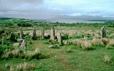
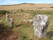
County Cork
.jpg) |
Ardgroom SW – Known locally as "Canfea", located southwest of the village of Ardgroom on the Beara peninsula. |
 |
Carrigagulla – About 18 stones located to the north of the village of Ballinagree. |
 |
Drombeg stone circle – Located west of Rosscarbery. |
 |
Knocknakilla – Located between Macroom Macroom Macroom is a market town in Ireland located in a valley on the River Sullane, a tributary of the River Lee, between Cork and Killarney. It is one of the key gateways to the tourist region of West Cork. The town recorded a population on 3,553 in the 2006 national census... and Millstreet Millstreet Millstreet is a town in north County Cork, Ireland with a population of approximately 1,500. It is located at the foot of Clara Mountain. The town's Catholic church is dedicated to St. Patrick. Since October 1985, the town has been twinned with Pommerit-le-Vicomte in Brittany, France... . |
 |
Glantane east – Located between Macroom and Millstreet. |
 |
Templebryan Stone Circle – Located between Bandon Bandon, County Cork Bandon is a town in County Cork, Ireland. With a population of 5,822 as of census 2006, Bandon lies on the River Bandon between two hills. The name in Irish means "Bridge of the Bandon", a reference to the origin of the town as a crossing-point on the river. In 2004 Bandon celebrated its... and Millstreet. |
County Kerry
.jpg) |
Lisseyviggeen – Located near Killarney Killarney Killarney is a town in County Kerry, southwestern Ireland. The town is located north of the MacGillicuddy Reeks, on the northeastern shore of the Lough Lein/Leane which are part of Killarney National Park. The town and its surrounding region are home to St... . Known locally as the Seven Sisters. |
Canada
| Lougheed – Located near Lougheed Town Centre Station Lougheed Town Centre Station Lougheed Town Centre Station is a station on the Millennium Line, part of the SkyTrain rapid transit system in Metro Vancouver, British Columbia.-Location:... . Known locally as the Standing Stones of Lougheed. |
Poland
 |
Odry – Odry in Poland. |
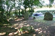
Cornwall
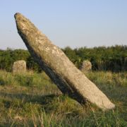 |
Boscawen-Un – Stone circle with a leaning pillar in its interior. |
 |
The Hurlers are a group of three stone circles on Bodmin Moor. |
 |
The Merry Maidens – near St Buryan St Buryan St Buryan is a civil parish and village in Cornwall, United Kingdom.The village of St Buryan is situated approximately five miles west of Penzance along the B3283 towards Land's End... in West Penwith Penwith Penwith was a local government district in Cornwall, England, United Kingdom, whose council was based in Penzance. The district covered all of the Penwith peninsula, the toe-like promontory of land at the western end of Cornwall and which included an area of land to the east that fell outside the... . |
 |
Tregeseal East – also known as the Tregeseal Dancing Stones, near St Just St Just in Penwith St Just is a town and civil parish in Cornwall, England, United Kingdom. The parish encompasses the town of St Just and the nearby settlements of Trewellard, Pendeen and Kelynack: it is bounded by the parishes of Morvah to the north-east, Sancreed and Madron to the east, St Buryan and Sennen to... in West Penwith Penwith Penwith was a local government district in Cornwall, England, United Kingdom, whose council was based in Penzance. The district covered all of the Penwith peninsula, the toe-like promontory of land at the western end of Cornwall and which included an area of land to the east that fell outside the... . |
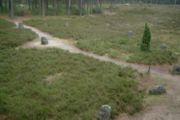
Cumbria
.jpg) |
Swinside – A near perfect circle located in the Lake District Lake District The Lake District, also commonly known as The Lakes or Lakeland, is a mountainous region in North West England. A popular holiday destination, it is famous not only for its lakes and its mountains but also for its associations with the early 19th century poetry and writings of William Wordsworth... . |
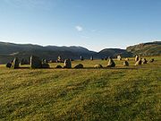 |
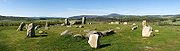
Castlerigg – A 33m diameter ring consisting of 38 stones. |
may2005.jpg) |
Long Meg – Around 51 stones set in an oval shape measuring 100 m on its long axis. |
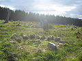
Derbyshire
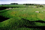 |
Arbor Low – near Youlgreave Youlgreave Youlgreave or Youlgrave is a village in the Derbyshire Peak District, lying on the River Bradford, four kilometres south of Bakewell. Both spellings are used on different local signposts and on different maps. The name possibly derives from "yellow grove" , though was historically called "Giolgrave"... in Derbyshire. |
 |
Doll Tor – near Birchover Birchover Birchover is a village and civil parish in the Peak District National Park, in Derbyshire, England. It is about five miles north-west of Matlock, and according to the 2001 UK census had a population of 362... in Derbyshire. |
 |
Nine Ladies – Nine stones located on Stanton Moor Stanton Moor Stanton Moor is a small upland area in the Derbyshire Peak District of central and northern England, lying between Matlock and Bakewell near the villages of Birchover and Stanton-in-Peak. It is known for its megaliths and erratics.-Archaeology:... . |
Dorset
 |
Kingston Russell – An 18 stone Bronze age Bronze Age The Bronze Age is a period characterized by the use of copper and its alloy bronze as the chief hard materials in the manufacture of some implements and weapons. Chronologically, it stands between the Stone Age and Iron Age... circle near Abbotsbury. |
50°41′18.7"N 2°35′56.2"W |
 |
The Nine Stones – A small nine stone circle near Winterbourne Abbas. | 50°42′43.2"N 2°33′9.8"W |
Shropshire
 |
Mitchell's Fold – A 30 stone ring (15 still standing). |
Somerset
 |
Stanton Drew – One of three circles located near the village of Stanton Drew. |
Warwickshire
.jpg) |
Rollright Stones – The "King's Men" are found near the village of Long Compton. |
Wiltshire
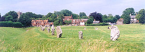 |
Avebury – A large stone circle surround the village of Avebury. |
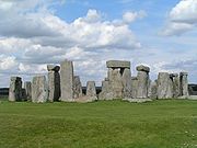 |
Stonehenge – A World Heritage site. |
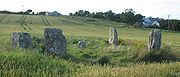
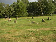
Aberdeenshire
 |
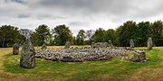
Cullerlie Stone Circle near Echt, Aberdeenshire. |
 |
Easter Aquhorthies Recumbent Stone Circle, near Inverurie, Aberdeenshire. |
 |
Loanhead of Daviot Recumbent Stone Circle, Aberdeenshire. |
 |
Tomnaverie Recumbent Stone Circle, Aberdeenshire. |
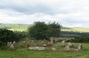
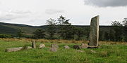
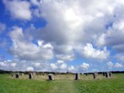
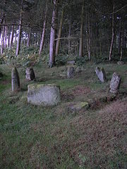
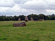
Blue cairn circle
Blue cairn circle
Blue cairn circle is a diameter stone circle in Aberdeenshire, Scotland. In the center is a large stone cairn with several pits in it....
, Aberdeenshire.
Dumfries and Galloway
| Twelve Apostles Stone Circle Twelve Apostles Stone Circle Twelve Apostles is the name given to a large stone circle situated between the villages of Holywood and Newbridge, near Dumfries, Scotland. It is the fifth largest stone circle in Britain and the largest on the mainland of Scotland.... , situated between Holywood and Newbridge, near Dumfries Dumfries Dumfries is a market town and former royal burgh within the Dumfries and Galloway council area of Scotland. It is near the mouth of the River Nith into the Solway Firth. Dumfries was the county town of the former county of Dumfriesshire. Dumfries is nicknamed Queen of the South... . |
Orkney
 |
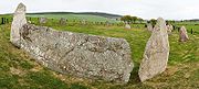
Ring of Brodgar – A 60 stone ring (27 still standing). |
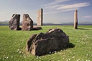 |
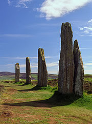
Stanes of Stenness, Orkney |
Western Isles
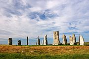 |
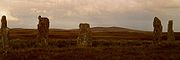
Callinish Island of Lewis. |
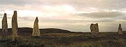 |
Callinish II Island of Lewis, a smaller stone circle. |
 |
Callinish III Island of Lewis, a smaller stone circle. |
 |
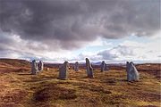
Callinish IV Island of Lewis, a smaller stone circle. |
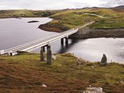 |
Callinish VIII Island of Lewis, a smaller stone semicircle. |