

List of mountains and hills of Saxony-Anhalt
Encyclopedia
This List of mountains and hills in Saxony-Anhalt shows a selection of high and/or well-known mountain
and hill
s in the German
state of Saxony-Anhalt
(in order of height). Whilst there is no universally agreed definition of a mountain, the definition used here is that a mountain is at least 2000 feet (609.6 m) high:
/Region
)
Mountain
Image:Himalaya_annotated.jpg|thumb|right|The Himalayan mountain range with Mount Everestrect 58 14 160 49 Chomo Lonzorect 200 28 335 52 Makalurect 378 24 566 45 Mount Everestrect 188 581 920 656 Tibetan Plateaurect 250 406 340 427 Rong River...
and hill
Hill
A hill is a landform that extends above the surrounding terrain. Hills often have a distinct summit, although in areas with scarp/dip topography a hill may refer to a particular section of flat terrain without a massive summit A hill is a landform that extends above the surrounding terrain. Hills...
s in the German
Germany
Germany , officially the Federal Republic of Germany , is a federal parliamentary republic in Europe. The country consists of 16 states while the capital and largest city is Berlin. Germany covers an area of 357,021 km2 and has a largely temperate seasonal climate...
state of Saxony-Anhalt
Saxony-Anhalt
Saxony-Anhalt is a landlocked state of Germany. Its capital is Magdeburg and it is surrounded by the German states of Lower Saxony, Brandenburg, Saxony, and Thuringia.Saxony-Anhalt covers an area of...
(in order of height). Whilst there is no universally agreed definition of a mountain, the definition used here is that a mountain is at least 2000 feet (609.6 m) high:
 |
Mountains
Name, Height in metres above sea level, Location (DistrictDistrict
Districts are a type of administrative division, in some countries managed by a local government. They vary greatly in size, spanning entire regions or counties, several municipalities, or subdivisions of municipalities.-Austria:...
/Region
Region
Region is most commonly found as a term used in terrestrial and astrophysics sciences also an area, notably among the different sub-disciplines of geography, studied by regional geographers. Regions consist of subregions that contain clusters of like areas that are distinctive by their uniformity...
)
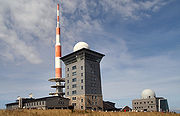
- Brocken (1141.1 metres (3,743.8 ft)), Harz district, Harz
- HeinrichshöheHeinrichshöheThe Heinrichshöhe is a subsidiary peak of the Brocken and, at , the second highest elevation in the Harz Mountains. The summit lies about 1.4 km southeast of the top of the Brocken near the Brocken Road in the Harz National Park....
(1,044 m), Harz district - KönigsbergKönigsberg (Brocken)The Königsberg is a neighbouring peak of the Brocken and, at 1034 m above sea level the third highest elevation in the Harz mountains. It lies on a long ridge that runs from southeast to northwest about 1.5 km south of the Brocken's summit....
(1.023 m), Harz district - Kleiner Brocken (1,019 m), Harz district
- Heinrichshöhe
- RenneckenbergRenneckenbergThe Renneckenberg is a high mountain in the Harz mountain range of central Germany within the borough of Wernigerode. It runs as a ridge from the Zeterklippen crags in the northwest to the Kapellenklippe in the southeast and lies close to the road from Schierke to the Brocken, the highest mountain...
(933 m), Harz district - Pferdekopf (857 m), Harz district
- ErdbeerkopfErdbeerkopfThe Erdbeerkopf is a high mountain in the High Harz in central Germany, northeast of Schierke in the state of Saxony-Anhalt.To the north and east, the forested summit is bordered by the Wormsgraben, the valley of the Wormke. To the south runs the Brocken Railway along the slopes of the...
(848 m), Harz district - Kleiner Winterberg (837 m), Harz district
- Großer Jägerkopf (745 m), Harz district
- WolfsklippenWolfsklippenThe Wolfsklippen is a granite mountain, high, in the Harz mountains in Central Germany with an observation platform on the summit. The mountain lies northeast of the Brocken, the highest elevation in the Harz, about 200 m east of the road way from Drei Annen Hohne to Plessenburg.- History...
(723 m), Harz district - ScharfensteinScharfensteinScharfenstein may refer to::* a district of Drebach in Erzgebirgskreis in SaxonyScharfenstein is the name of the following geographic features:* Scharfenstein , Oybin in Saxony, known as Lausitzer Matterhorn...
(696 m), Harz district - Oberer Meineckenberg (644 m), Harz district
- CarlshaushöheCarlshaushöheThe Carlshaushöhe is a mountain, , in the Harz in the German state of Saxony-Anhalt.- Geographical location :It is located southwest of Hasselfelde between Trautenstein to the north, Benneckenstein to the west and Sophienhof in the borough of Ilfeld in Thuringia to the south.- Carlshaus Tower :On...
(626 metres (2,053.8 ft)), Harz district
Hills
- Großer Gierskopf (595 metres (1,952.1 ft)), Harz district
- Schalliete (595 m), Harz district
- Zwißelkopf (587 m), Harz district
- Ramberg (582 m), Harz district
- Großer AuerbergGroßer AuerbergThe Große Auerberg is a hill, high, in the eastern Harz in the district of Mansfeld-Südharz in the German state of Saxony-Anhalt.The hill has twin peaks that are 580.4 m and 580.3 m high, which are about 500 metres apart...
(580 m), Mansfeld-Südharz district, Harz - Rauher Jacob (568 m), Harz district
- Ortberg (549 m), Harz district
- Leckenkopf (546 m), Harz district
- Großer Hornberg (537 m), Harz district
- Großer Stemberg (517 m), Harz district
- Büchenberg (516 m), Harz district
- HilmersbergHilmersbergThe Hilmersberg is a hill, 362 metres above sea level in the Solling, a hill range in the German state of Lower Saxony. It lies west of Kammerborn and east of Polier, part of the borough of Bodenfelde in the Solling-Vogler Nature Park....
(507 m), Harz district - BockbergBockbergThe Bockberg is a hill, , near Königshütte in Harz district in the Harz mountains of central Germany. Since 1967 the hill and its surrounding area have been protected as a nature reserve....
(495 m), Harz district - Hohe Warte (374 m), Harz district
- Schimmelsberg (324 m), Mansfeld-Südharz district, Harz
- Buchenberg (314 m), Harz district, Huy
- Orlas (305 m), Landkreis BurgenlandkreisBurgenlandkreisThe Burgenlandkreis was a district in the south of Saxony-Anhalt, Germany. Neighboring districts are Merseburg-Querfurt, Weißenfels, Leipziger Land, Aschersleben-Staßfurt, Altenburger Land, Greiz, district-free Gera, Saale-Holzland, Weimarer Land, Sömmerda and the Kyffhäuserkreis.- History :The...
, Finne - Großer FallsteinGroßer FallsteinThe Großer Fallstein is a wooded hill region in the German state of Saxony-Anhalt. It lies in the district of Harz on the territory of the town of Osterwieck, north of the Harz Mountains...
(288 m), Harz district, Fallstein - Butterberg (Ilsenburg)Butterberg (Ilsenburg)The Butterberg in the Harz district of the German state of Saxony-Anhalt lies about half-way between Ilsenburg and Drübeck, at a height of . From the top, the Harz Foreland and the ridges of the Harz mountains may be seen. The view of Ilsenburg however is almost completely hidden by the nearby...
(279 m), Harz district - Petersberg (251 m), Saale district
- Domburg (241 m), Harz district, HakelHakelThe Hakel is a palaeontological formation located in Lebanon. It dates to the Cretaceous period....
- Bullenberg (210.6 m), Börde district, Lappwald
- Edelberg (209 m), Börde district, Hohes HolzHohes HolzThe Hohes Holz is the only large wooded area in the otherwise open, agriculturally intensively-farmed western part of the Magdeburg Börde in the German state of Saxony-Anhalt. The region forms the southern part of a ridge that runs from the Lappwald in the north to the Bodeknie near Oschersleben ....
- Kniel (205 m), Börde district, southeastern extension of the Lappwald Ridge
- Hohe Gieck (193 m), Wittenberg district, Naturpark Dübener Heide
- Michelsberg (185 m), Wittenberg district, FlämingFlämingThe Fläming Heath is a region and a hill chain that reaches over 100 km from the Elbe river to the Dahme River in the German states Saxony-Anhalt and Brandenburg. Its highest elevation is the Hagelberg...
- Hirseberg (184 m), Wittenberg district, Fläming
- Langer Berg (160 m), Altmarkkreis Salzwedel, Zichtau Forest and Hellberge
- Großer Wartberg (146 m), Börde district, Börde
- Butterberg (141 m), Börde district, Flechtingen Hills
- Wartenberg (121 m), Salzland district, Börde
- Ochsenberg (109 m), Salzland district
- Kappaun-Berg (105,4 m), Landkreis Jerichower Land
- Dolchauer Berg (95 metres (311.7 ft)), Salzwedel districtAltmarkkreis SalzwedelAltmarkkreis Salzwedel is a district in Saxony-Anhalt, Germany. It is bounded by the districts Gifhorn, Uelzen, Lüchow-Dannenberg in Lower Saxony, and the districts of Stendal and Ohrekreis.- History :...
, Kalbescher Werder