
List of closed regional railway stations in Victoria
Encyclopedia
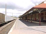
Train station
A train station, also called a railroad station or railway station and often shortened to just station,"Station" is commonly understood to mean "train station" unless otherwise qualified. This is evident from dictionary entries e.g...
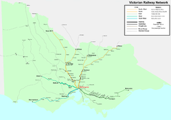
and railway lines in Victoria
Victoria (Australia)
Victoria is the second most populous state in Australia. Geographically the smallest mainland state, Victoria is bordered by New South Wales, South Australia, and Tasmania on Boundary Islet to the north, west and south respectively....
, Australia
Australia
Australia , officially the Commonwealth of Australia, is a country in the Southern Hemisphere comprising the mainland of the Australian continent, the island of Tasmania, and numerous smaller islands in the Indian and Pacific Oceans. It is the world's sixth-largest country by total area...
. Many of these stations and lines have been abandoned or demolished. For closed railway stations in suburban Melbourne, see List of closed railway stations in Melbourne.
Passenger lines proposed for reopening
The Mildura line, whilst closed to passenger rail services at present has seen State Government proposals for their reintroduction. The line is currently open to freight; while an upgrade to the line was announced in 2006, this is limited to improving the current 40 km/h (25 mph) maximum speed on many sections, and is not relevant to any hopes that a passenger train service might recommence.In December 2008 as part of the Victorian Transport Plan
Victorian Transport Plan
The Victorian Transport Plan is a now defunct transport planning framework for the state of Victoria, Australia announced on Monday 9 December 2008 by then Premier of Victoria, John Brumby...
the state government announced that Maryborough station would see 14 V/Line
V/Line
V/Line is a not for profit regional passenger train and coach service in Victoria, Australia. It was created after the split-up of VicRail in 1983. V/Line is owned by the V/Line Corporation which is a Victorian State Government statutory authority...
passenger rail services extended to the station every week, commencing 2010 at a cost of $50 million.
There was originally a planned upgrade to a fourth line: the Leongatha line in South Gippsland. This plan was dropped in May 2008 after progress had stalled for some years. A tourist line, the South Gippsland Tourist Railway, continues to operate along a section of the line. The Leongatha line still has a chance in the future of reopening. The Liberals said if they win the next Victorian election, they will reopen the line if the transport crisis gets worse. The Labour Government said in May last year they might leave the track from Cranbourne - Nyora if needed in the future. But it has a chance of becoming a rail trail
Rail trail
A rail trail is the conversion of a disused railway easement into a multi-use path, typically for walking, cycling and sometimes horse riding. The characteristics of former tracks—flat, long, frequently running through historical areas—are appealing for various development. The term sometimes also...
. Cranbourne - Nyora line is going to be left as a disused railway line. Leongatha and Cobram have been talked about to reopen in the future.
Mildura line
Once served by the VinelanderVinelander
The Vinelander was a named passenger train that operated by the Victorian Railways between Melbourne and Mildura, Victoria, Australia from 1972 to 1993. Operating overnight along the Mildura line, it included motorail and sleeping car facilities.-History:...
service, the line branches from the Serviceton line at Ballarat.
- Ballarat
- Creswick
- Clunes
- Maryborough
- Dunolly
- St Arnaud
- Donald
- Birchip
- Ouyen
- Red Cliffs
- Irymple
- Mildura
Closed lines
The following lines are either closed to regular passenger services, freight only, part of tourist and heritage railways, or closed and removed.- Northern:
- Melbourne - Bendigo:
- Lancefield railway line
- Daylesford railway line (Daylesford Spa Country RailwayDaylesford Spa Country RailwayThe Daylesford Spa Country Railway is a volunteer-operated broad gauge tourist railway located in Victoria, Australia. It operates on a section of the formerly disused and dismantled Daylesford line...
) - Castlemaine-Maryborough railway line
- Maldon railway line (Victorian Goldfields RailwayVictorian Goldfields RailwayThe Victorian Goldfields Railway is a broad gauge tourist railway in Victoria, Australia. It operates along a formerly disused branch line between the towns of Maldon and Castlemaine.-History:...
) - Redesdale railway line
- Heathcote railway line
- West from Bendigo:
- Robinvale railway line (freightFreight trainA freight train or goods train is a group of freight cars or goods wagons hauled by one or more locomotives on a railway, ultimately transporting cargo between two points as part of the logistics chain...
only) - Wedderburn railway line
- Eaglehawk-Inglewood railway line
- Kulwin railway line (freightFreight trainA freight train or goods train is a group of freight cars or goods wagons hauled by one or more locomotives on a railway, ultimately transporting cargo between two points as part of the logistics chain...
only) - Stony Crossing railway line
- Yungera railway line
- Kerang-Koondrook TramwayKerang-Koondrook TramwayThe Kerang-Koondrook Tramway was an Australian private railway of broad gauge, running from the state owned Victorian Railways network at Kerang to the Murray River town of Koondrook, with intermediate stations at Yeoburn, Hinksons, Teal Point and Gannawarra.The long line was opened in 1889, with...
- Robinvale railway line (freight
- East from Bendigo:
- Cohuna railway lineCohuna railway lineThe Cohuna Line is a closed railway line in the north of Victoria, Australia. Branching off the main North railway at Elmore it ran east to a final terminus at Cohuna.-Stations:Cohuna Railway Station 185 Miles*1915 - 1 March 1981....
- Toolamba-Echuca railway line (freightFreight trainA freight train or goods train is a group of freight cars or goods wagons hauled by one or more locomotives on a railway, ultimately transporting cargo between two points as part of the logistics chain...
only) - Deniliquin railway line (freightFreight trainA freight train or goods train is a group of freight cars or goods wagons hauled by one or more locomotives on a railway, ultimately transporting cargo between two points as part of the logistics chain...
only) - Balranald railway line (freightFreight trainA freight train or goods train is a group of freight cars or goods wagons hauled by one or more locomotives on a railway, ultimately transporting cargo between two points as part of the logistics chain...
only to MoulameinMoulamein, New South WalesMoulamein is a small town in New South Wales, Australia, in the Wakool Shire. At the 2006 census, Moulamein had a population of 349 people. Moulamein is the oldest town in the Riverina....
in New South WalesNew South WalesNew South Wales is a state of :Australia, located in the east of the country. It is bordered by Queensland, Victoria and South Australia to the north, south and west respectively. To the east, the state is bordered by the Tasman Sea, which forms part of the Pacific Ocean. New South Wales...
)
- Cohuna railway line
- North Eastern:
- Melbourne - Wodonga:
- Heathcote railway line
- Mansfield railway line
- Tatong railway line
- Oaklands railway line, VictoriaOaklands railway line, VictoriaThe Oaklands railway line is a freight only railway line in north eastern Victoria, Australia. The line branches from the main North East railway at Benalla station until it connects with the New South Wales railway network at Oaklands, New South Wales....
(freightFreight trainA freight train or goods train is a group of freight cars or goods wagons hauled by one or more locomotives on a railway, ultimately transporting cargo between two points as part of the logistics chain...
only) - Whitfield railway line
- Bright railway line
- Yackandandah railway line
- Peechelba railway line
- Wahgunyah railway line
- Cudgewa railway line (freightFreight trainA freight train or goods train is a group of freight cars or goods wagons hauled by one or more locomotives on a railway, ultimately transporting cargo between two points as part of the logistics chain...
only to BandianaBandiana railway station, VictoriaBandiana was a closed station located in the town of Bandiana, on the Cudgewa railway line in Victoria, Australia. Today there is nothing left of the station....
)
- Goulburn Valley:
- Rushworth railway line
- Toolamba-Echuca railway line (freightFreight trainA freight train or goods train is a group of freight cars or goods wagons hauled by one or more locomotives on a railway, ultimately transporting cargo between two points as part of the logistics chain...
only) - Katamatite railway line (freightFreight trainA freight train or goods train is a group of freight cars or goods wagons hauled by one or more locomotives on a railway, ultimately transporting cargo between two points as part of the logistics chain...
only to DookieDookie, VictoriaDookie is a town in the Goulburn Valley region of Victoria, Australia. It is situated in a valley between Mount Major and Mount Saddleback. Dookie is a farming community. At the 2006 census, Dookie had a population of 286....
) - Picola railway line
- Cobram railway line
- Tocumwal railway line (freightFreight trainA freight train or goods train is a group of freight cars or goods wagons hauled by one or more locomotives on a railway, ultimately transporting cargo between two points as part of the logistics chain...
only beyond SheppartonShepparton, VictoriaShepparton is a city located on the floodplain of the Goulburn River in the north east of Victoria, Australia approximately north-east of Melbourne. It is the fifth largest city in Victoria, Australia. The estimated population of Shepparton's statistical area is 48,926.It began as a sheep station...
)
- Midland:
- Geelong-Ballarat railway line (freightFreight trainA freight train or goods train is a group of freight cars or goods wagons hauled by one or more locomotives on a railway, ultimately transporting cargo between two points as part of the logistics chain...
only) - Gheringhap-Maroona railway line (freightFreight trainA freight train or goods train is a group of freight cars or goods wagons hauled by one or more locomotives on a railway, ultimately transporting cargo between two points as part of the logistics chain...
and The Overland only) - Mildura railway line (freightFreight trainA freight train or goods train is a group of freight cars or goods wagons hauled by one or more locomotives on a railway, ultimately transporting cargo between two points as part of the logistics chain...
only)
- Geelong-Ballarat railway line (freight
- Ballarat region:
- Waubra railway line
- Ballarat Cattle Yards railway line
- Buninyong railway line
- Skipton railway line
- Newtown-Colac railway line
- Ballarat - Serviceton:
- Avoca railway line
- Navarre railway line
- Carpolac railway line
- Bolangum railway line
- Patchewollock railway line (freightFreight trainA freight train or goods train is a group of freight cars or goods wagons hauled by one or more locomotives on a railway, ultimately transporting cargo between two points as part of the logistics chain...
only to HopetounHopetoun, VictoriaHopetoun is a town which serves as the major service centre for the Southern Mallee area of Victoria, Australia. Hopetoun is situated 400 kilometres north-west of Melbourne on the Henty Highway in the Shire of Yarriambiack...
) - Yaapeet railway line (freightFreight trainA freight train or goods train is a group of freight cars or goods wagons hauled by one or more locomotives on a railway, ultimately transporting cargo between two points as part of the logistics chain...
only) - Yanac railway line
- Ballarat - Mildura:
- Avoca railway line (freightFreight trainA freight train or goods train is a group of freight cars or goods wagons hauled by one or more locomotives on a railway, ultimately transporting cargo between two points as part of the logistics chain...
only) - Castlemaine-Maryborough railway line (freightFreight trainA freight train or goods train is a group of freight cars or goods wagons hauled by one or more locomotives on a railway, ultimately transporting cargo between two points as part of the logistics chain...
only to MoolortMoolort, VictoriaMoolort is situated in central Victoria approximately half way between the major rural cities of Ballarat and Bendigo. It can be found at . The Universal Grid Reference for this area is 7623-1-1 Cairn Curran.- Industry :...
from MaryboroughMaryborough, Victoria-Education:Maryborough has three schools:*Highview Christian Community College*Maryborough Education Centre Years Prep–12*St Augustine's Primary School Grades Prep–6-Music:...
) - Pinnaroo railway line (freightFreight trainA freight train or goods train is a group of freight cars or goods wagons hauled by one or more locomotives on a railway, ultimately transporting cargo between two points as part of the logistics chain...
only) - Millewa South railway line
- Morkalla railway line
- Ballarat to Daylesford railway line
- Avoca railway line (freight
- Ararat - Portland:
- Portland railway line (freightFreight trainA freight train or goods train is a group of freight cars or goods wagons hauled by one or more locomotives on a railway, ultimately transporting cargo between two points as part of the logistics chain...
only) - Grampians railway line
- Balmoral railway line
- Koroit-Hamilton railway line
- Coleraine railway line
- Casterton railway line
- Mount Gambier railway line (isolated by rail gaugeRail gaugeTrack gauge or rail gauge is the distance between the inner sides of the heads of the two load bearing rails that make up a single railway line. Sixty percent of the world's railways use a standard gauge of . Wider gauges are called broad gauge; smaller gauges, narrow gauge. Break-of-gauge refers...
)
- Portland railway line (freight
- South Western:
- Geelong-Ballarat railway line
- Fyansford railway line
- Cunningham Pier railway line
- Queenscliff railway line (Bellarine Peninsula RailwayBellarine Peninsula RailwayThe Bellarine Railway is a volunteer-operated steam-driven tourist railway located in Victoria, Australia. It operates on a 16 km section of a formerly disused branch line on the Bellarine Peninsula between the coastal town of Queenscliff and Drysdale, near Geelong.- History as a working...
) - Geelong Racecourse railway line
- Wensleydale railway lineWensleydale railway lineThe Wensleydale railway line was a railway branch line in Victoria, Australia. It ran for approximately 18km from the Port Fairy railway line near Moriac to Wensleydale, Victoria. It was built in the 1890's with the intention of transporting timber and gravel out of the area...
- Forrest railway line
- Newtown-Colac railway line
- Crowes railway line
- Alvie railway line
- Timboon railway line
- Mortlake railway line
- Koroit-Hamilton railway line
- Port Fairy railway line (open as far as WarrnamboolWarrnambool, Victoria-Cityscape:The original City of Warrnambool was a 4x8 grid, with boundaries of Lava Street , Japan Street , Merri Street and Henna Street . In the nineteenth century, it was intended that Fairy Street – with its proximity to the Warrnambool Railway Station – would be the main street of...
)
- Eastern:
- Melbourne - Orbost:
- Orbost railway lineOrbost railway lineThe Orbost railway line is a railway serving the Latrobe Valley and Gippsland regions of Victoria, Australia...
(open as far as BairnsdaleBairnsdale, VictoriaBairnsdale is a small city in Gippsland, Victoria, Australia. With a population at the 2006 census of 11,282, it is a major regional centre of eastern Victoria along with Traralgon and Sale....
) - Noojee railway line
- Walhalla railway line (Walhalla Goldfields RailwayWalhalla Goldfields RailwayThe Walhalla Goldfields Railway is a gauge tourist railway located in the Thomson River and Stringers Creek valleys in Gippsland, Victoria, Australia, near the former gold-mining town and tourist destination of Walhalla.- History :...
) - Thorpdale railway line
- Yallourn railway line
- Mirboo North railway line
- Maryvale railway line
- Maffra railway line
- Briagolong railway line
- Sale Wharf railway line
- Bairnsdale Wharf railway line
- Orbost railway line
- South Gippsland:
- Strzelecki railway line
- Wonthaggi railway line
- Outtrim railway line
- Barry Beach railway line
- Welshpool Jetty railway line
- Woodside railway line
- South Gippsland railway line (South Gippsland RailwaySouth Gippsland RailwayThe South Gippsland Railway is a tourist railway located in south Gippsland, Victoria, Australia. It controls a section of the former South Gippsland line between Nyora and Leongatha, operating services from Leongatha to Nyora via Korumburra taking around 65 minutes, trains operate on sundays,...
)
South West
| Name | Line | Location | Opened | Closed | Current Status |
|---|---|---|---|---|---|
| Moriac | Warrnambool line | Moriac Moriac, Victoria Moriac is a rural town in Victoria, Australia, located approximately west of Geelong. It forms part of the Surf Coast Shire. At the 2006 census, Moriac had a population of 594.... |
? | Late 1970s | Demolished |
| Pirron Yallock | Warrnambool line | Pirron Yallock | ? | Late 1970s | Platform demolished, building stands |
| Panmure | Warrnambool line | Panmure Panmure, Victoria Panmure is a small town in the south west of Victoria, Australia. At the 2006 census, Panmure and the surrounding area had a population of 421.... |
? | Late 1970s | Demolished |
| Allansford | Warrnambool line | Allansford Allansford, Victoria Allansford is a town in the Western District of Victoria, Australia. It is in the City of Warrnambool local government area. The Hopkins River flows through the town.-History:The Post Office opened on 1 January 1860... |
? | 1981 | Demolished |
West
| Name | Line | Location | Opened | Closed | Current Status |
|---|---|---|---|---|---|
| Parwan | Ballarat line | Parwan-Exford Road, Parwan | ? | 1980s | Demolished |
| Rowsley Rowsley railway station Rowsley railway station was opened in 1849 by the Manchester, Buxton, Matlock and Midlands Junction Railway to serve the village of Rowsley in Derbyshire.-Opening:... |
Ballarat line | Rowsley Rowsley, Victoria Rowsley is a small town approximately 50km south of Melbourne. It's local government area the Shire of Moorabool. The town is mostly farmland and has a camp-site operated by YMCA. The camp-site is named Lady Northcote Recreational Camp and serves many schools with a range of activities. The post... |
? | Demolished | |
| Llandello | Ballarat line | Ballan Ballan, Victoria Ballan is a small town in the state of Victoria, Australia located on the Werribee River north west of Melbourne. At the 2006 census, Ballan had a population of 1,807.It is the main administrative centre for the Shire of Moorabool Local Government Area.... |
? | Demolished | |
| Gordon | Ballarat line | Gordon Gordon, Victoria Gordon is a town in Victoria, Australia. The town is located in the Shire of Moorabool Local Government Area, west of the state capital, Melbourne. At the 2006 census, Gordon had a population of 453.... |
? | Late 1970s | Intact, leased out |
| Millbrook | Ballarat line | Millbrook Millbrook, Victoria Millbrook is a rural district in the state of Victoria, Australia, located north west of Melbourne. At the time of the 2006 census, Millbrook had a population of 550.The soil is volcanic and well-adapted to cereals, potatoes and grazing. The landscape is undulating and preserves remnants of the... |
1885 | 1898 | Demolished |
| Wallace | Ballarat line | Wallace Wallace, Victoria Wallace is a town in Victoria, Australia. The town is located in the Shire of Moorabool Local Government Area, north west of the state capital, Melbourne.The township was established in the 1880s, the Post Office opening on 22 February 1885.... |
1885 | 1898 | |
| Bungaree | Ballarat line | Bungaree Bungaree, Victoria Bungaree is a town in Victoria, Australia. The town is located west of the state capital, Melbourne and east of the regional centre of Ballarat, on the Western Freeway and in the Shire of Moorabool local government area. At the 2006 census, Bungaree and the surrounding area had a population of... |
? | 1981 | Platform intact |
| Dunnstown | Ballarat line | Dunnstown Dunnstown, Victoria Dunnstown is a town in Victoria, Australia. The town is located in the Shire of Moorabool, west of the state capital, Melbourne and close to the regional centre of Ballarat... |
1885 | 1898 | Platform demolished, goods shed remains |
| Warrenheip | Ballarat line | Warrenheip Warrenheip, Victoria Warrenheip is a small suburb of Ballarat, Victoria, Australia located on the western rural-urban fringe. At the 2006 census, Warrenheip had a population of 435.... |
? | Late 1970s | Demolished |
| Burrumbeet | Ararat line | Burrumbeet Burrumbeet, Victoria Burrumbeet is a town in western Victoria, Australia. The town is located on the Western Highway, west of the state capital, Melbourne and west of the regional centre, Ballarat... |
? | ? | Platform intact |
| Trawalla | Ararat line | Trawalla Trawalla, Victoria Trawalla is a town in central Western Victoria, Australia, located on the Western Highway, 41 km west of Ballarat and 154 km west of Melbourne, in the Shire of Pyrenees. At the 2006 census, Trawalla and the surrounding agricultural area had a population of 224.Trawalla sits at the... |
? | Late 1970s | Intact |
| Buangor | Ararat line | Buangor | ? | Late 1970s | Intact, but in disrepair |
North
| Name | Line | Location | Opened | Closed | Current Status |
|---|---|---|---|---|---|
| Rupertswood | Bendigo line | Within Sunbury Sunbury, Victoria Sunbury is a regional city, located north-west of Melbourne's central business district, in the state of Victoria, Australia. Its Local Government Area is the City of Hume. At the 2006 Census, Sunbury had a population of 31,000... |
1870s | December 2004 | Intact, one platform demolished. |
| Carlsruhe | Bendigo line, former junction of Daylesford line | ?, Carlsruhe Carlsruhe, Victoria Carlsruhe is a small rural town in the Shire of Macedon Ranges between Woodend and Kyneton, alongside the old Calder Highway, although now bypassed bypassed by the Calder Freeway. It is approximately 50 minutes from both Melbourne and Bendigo... |
? | Destaffed 1978, closed 1982 | Intact, building leased out. |
| Taradale | Bendigo line | Station Street, Taradale Taradale, Victoria Taradale is a small town in Victoria, Australia. It is located on the Calder Highway between Melbourne and Bendigo. Its local government area is the Shire of Mount Alexander. At the 2006 census, Taradale had a population of 199.... |
? | 1976 | Intact, leased out. |
| Elphinstone | Bendigo line | ?, Elphinstone Elphinstone, Victoria Elphinstone is a town in Victoria, Australia. The town sits at the junction of the former Calder Highway and the former Pyrenees Highway between Malmsbury and Castlemaine near Taradale and Chewton... |
? | Late 1970s | Intact, building leased out. |
| Harcourt | Bendigo line | ?, Harcourt Harcourt, Victoria Harcourt is a small Central Highlands town located approximately 9 km northeast of Castlemaine, where the Midland Highway meets the Calder Highway. At the 2006 census, Harcourt had a population of 439.-History:... |
? | Late 1970s | Intact, leased out |
| Golden Square | Bendigo line | ?, Golden Square Golden Square, Victoria Golden Square is a suburb of Bendigo in Victoria, Australia.-Today:Golden Square is home to The Bulldogs Football and Netball Team competing in the Bendigo Football League... |
? | Late 1970s | Intact, building leased out. |
| Raywood | Swan Hill line | Raywood Raywood, Victoria Raywood is a town in northern Victoria, Australia. The town is located in the City of Greater Bendigo, north of the state capital, Melbourne. At the 2006 census, Raywood had a population of 291.Raywood Post Office opened on 4 January 1864... |
? | Late 1970s | ? |
| Mitiamo | Swan Hill line | Mitiamo Mitiamo, Victoria Mitiamo is a town in northern Victoria, Australia. The town is located in the Shire of Loddon, north of the state capital, Melbourne. At the 2006 census, Mitiamo had a population of 76.... |
? | Late 1970s | ? |
| Macorna | Swan Hill line | Macorna | ? | Late 1970s | ? |
| Lake Boga | Swan Hill line | Lake Boga Lake Boga, Victoria Lake Boga is a town in Victoria, Australia. It is situated within the Rural City of Swan Hill within the Mallee region of north-west Victoria. At the 2006 census, Lake Boga had a population of 725... |
? | Late 1970s | Demolished |
North East
| Name | Line | Location | Opened | Closed | Current Status |
|---|---|---|---|---|---|
| Mangalore | Shepparton line | Mangalore Toolamba, Victoria Toolamba is a town in the Goulburn Valley region of Victoria, Australia. The town is located in the City of Greater Shepparton Local government area, north of the state capital, Melbourne. At the 2006 census, Toolamba and the surrounding area had a population of 873.The Post Office opened on 1... |
? | Early 1980s | Demolished |
| Tabilk | Shepparton line | Tabilk | ? | Late 1980s | Demolished |
| Wahring | Shepparton line | Wahring | ? | Late 1970s | Demolished |
| Arcadia | Shepparton line | Arcadia Arcadia, Victoria Arcadia is a small town in Victoria, Australia. It is located on Kennedys Road, in the City of Greater Shepparton, south of Shepparton. At the 2006 census, Arcadia had a population of 659.... |
? | Late 1970s | Demolished |
| Toolamba | Shepparton line | Toolamba Toolamba, Victoria Toolamba is a town in the Goulburn Valley region of Victoria, Australia. The town is located in the City of Greater Shepparton Local government area, north of the state capital, Melbourne. At the 2006 census, Toolamba and the surrounding area had a population of 873.The Post Office opened on 1... |
? | Late 1970s | Demolished |
| Longwood | Albury line | Longwood Longwood, Victoria Longwood is a town in northern Victoria, Australia. The town is located in the Shire of Strathbogie Local government area, from the state capital, Melbourne... |
November 20, 1872 | October 4, 1981 | Demolished |
| Baddaginnie | Albury line | Baddaginnie Baddaginnie, Victoria Baddaginnie is a small town in Victoria, Australia. It is located on the Albury-Wodonga railway line, in the Rural City of Benalla, 12 kilometres south-west of Benalla itself on the old Hume Highway. It is situated in mainly flat unforested country, one kilometre west of Baddaginnie Creek... |
June 19, 1882 | July 5, 1978 | Demolished, goods platform still visible |
| Glenrowan | Albury line | Glenrowan Glenrowan, Victoria Glenrowan is a small town located in the Wangaratta Local Government Area of Victoria, Australia. It is 184 kilometres north-east of Melbourne and 14 kilometres from Wangaratta and located near the Warby Ranges and Mount Glenrowan... |
November 2, 1874 | October 4, 1981 | Demolished, rebuilt 2001 |
| Barnawartha | Albury line | Barnawartha Barnawartha, Victoria Barnawartha is a small town located on the Hume Highway in regional north-east Victoria, Australia, approximately from Melbourne on the banks of Indigo Creek which runs into the Murray River to the north.... |
November 21, 1873 | Late 1970s | Intact |
East
| Name | Line | Location | Opened | Closed | Current Status |
|---|---|---|---|---|---|
| Fernbank | Bairnsdale Orbost railway line The Orbost railway line is a railway serving the Latrobe Valley and Gippsland regions of Victoria, Australia... line |
Fernbank Fernbank, Victoria Fernbank is a small country town on the Perry River in Victoria, Australia, approximately 310 km east of Melbourne. As of the 2001 census, the small town of Fernbank had a population of 630... |
? | Late 1970s | Demolished |
| Lindenow | Bairnsdale Orbost railway line The Orbost railway line is a railway serving the Latrobe Valley and Gippsland regions of Victoria, Australia... line |
Lindenow Lindenow, Victoria Lindenow is a town in Victoria, Australia, located on Dargo Road, in the Shire of East Gippsland near Bairnsdale.At the 2006 census, Lindenow had a population of 338.... |
? | Late 1970s | Demolished |
| Hillside Hillside railway station, Victoria Hillside is a closed station located in the town of Hillside, on the Bairnsdale railway line in Victoria, Australia. It was 262 km from Southern Cross station. Although the station has been demolished, a siding is located at the station, which was last used by Freight Australia for log trains... |
Bairnsdale Orbost railway line The Orbost railway line is a railway serving the Latrobe Valley and Gippsland regions of Victoria, Australia... line |
? | ? | Late 1970s | Demolished |
On closed lines
| Name | Line | Location | Opened | Closed | Current Status |
|---|---|---|---|---|---|
| Kensington | Queenscliff line | ? Leopold Leopold, Victoria Leopold is a residential eastern suburb of Geelong and is a gateway to the Bellarine Peninsula.-History:The area was formerly known as Kensington. The Post Office opened as Kensington on 19 May 1858, and was renamed Kensington Hill in 1882, Leopold Hill in 1884 and Leopold in 1885. -The town... |
1880 | 1881 | Demolished |
| Queenscliff Junction | Queenscliff line | ? South Geelong South Geelong, Victoria South Geelong, also referred to as Geelong South, is a residential and industrial southern suburb of Geelong, Victoria, Australia. The suburb is adjacent to the Geelong central business district, with the Barwon River forming the suburb's southern border... |
1879 | 1901 | Demolished |
| Queenscliff line | ? Breakwater Breakwater, Victoria Breakwater is a residential and industrial suburb of Geelong, Victoria, Australia, located on the Barwon River, 4 km south-south-east of the Geelong central business district... |
1891 | ? | Demolished | |
| Scarborough | Queenscliff line | ? | 1889 | 1914 | Demolished |
| Cheethams Siding | Queenscliff line | Whittington Whittington, Victoria Whittington is a residential suburb of Geelong, Victoria, Australia, located 4km south-east of the city centre. It is bordered by Boundary, Townsend and Coppards roads and by the former Geelong to Queenscliff railway line now known as the Bellarine Rail Trail.... |
1909 | 1959 | Demolished |
| Moolap | Queenscliff line | Moolap Station Road, Moolap Moolap, Victoria Moolap is a residential and industrial suburb of Geelong, Victoria, Australia. The name Moolap is derived from an Aboriginal word for nearby Point Henry, moo-laa, thought to mean 'men gathering to go fishing'. Moolap in Aboriginal tongue means "Shady Place" .... |
1881 | 1961 | Demolished |
| Leopold | Queenscliff line | Leopold Leopold, Victoria Leopold is a residential eastern suburb of Geelong and is a gateway to the Bellarine Peninsula.-History:The area was formerly known as Kensington. The Post Office opened as Kensington on 19 May 1858, and was renamed Kensington Hill in 1882, Leopold Hill in 1884 and Leopold in 1885. -The town... |
1881 as Kensington Flat, renamed in 1886 | 1961 | Demolished |
| Curlewis | Queenscliff line | Curlewis Curlewis, Victoria Curlewis is a bounded rural locality of the City of Greater Geelong Local Government Area on the Bellarine Peninsula, Victoria, Australia. At the 2006 census, Curlewis had a population of 399.-References:... |
1914 | 1961 | Demolished |
| Mannerim | Queenscliff line | Mannerim Mannerim, Victoria Mannerim is a semi-rural locality on the Bellarine Peninsula of Victoria, Australia.Characterised by hobby farms and wineries, it is centred on the Grubb Road-Bellarine Highway intersection.-History:... |
1883, renamed from Marcus Hill station in 1890 | 1961 | Demolished |
| Marcus | Queenscliff line | ? Marcus | 1883 as Ocean Grove station, renamed in 1896 as Marcus Hill and renamed again in 1904 | 1961 | Demolished |
| Tylden | Daylesford line | ?, Tylden Tylden, Victoria Tylden is a small country town in central Victoria, Australia. The town is located in the Shire of Macedon Ranges Local Government Area, north west of the state capital, Melbourne. At the 2006 census, Tylden has a population of 350.-Today:... |
? | 1978 | Demolished |
| Fern Hill | Daylesford line | ? | ? | 1978 | Demolished |
| Woodleigh | Wonthaggi line | ? | 1910 | late 1977 | Intact, Demolished |
| Kernot | Wonthaggi line | ? | 1910 | late 1977 | Intact, Demolished |
| Almurta | Wonthaggi line | ? | 1910 | late 1977 | Intact, Demolished |
| Glen Forbes | Wonthaggi line | ? | 1910 | late 1977 | Intact, Demolished |
| Woolamai | Wonthaggi line | ? | 1910 | late 1977 | Intact, Demolished |
| Anderson | Wonthaggi line | ? | 1910 | late 1977 | Intact, Demolished |
| Kilcunda | Wonthaggi line | ? | 1910 | late 1977 | Intact, Demolished |
| Dalyston | Wonthaggi line | ? | 1910 | late 1977 | Intact, Demolished |
| Wonthaggi | Wonthaggi line | ? | 1910 | late 1977 - 78 | Intact, Used (Station Has been transformed into Local Museum) |
| Clyde Clyde railway station, Victoria Clyde was a railway station on the South Gippsland line in South Gippsland, Victoria, Australia, the station operated until the closure of the line between Cranbourne Station and Leongatha Station in 1993... |
South Gippsland line | Railway Rd, Clyde Clyde, Victoria Clyde is a suburb in Melbourne, Victoria, Australia, 48 km south-east from Melbourne's central business district. Its Local Government Area is the City of Casey. At the 2006 Census, Clyde had a population of 1,224.-History:... |
1892 | 1994 | Intact, Demolished |
| Tooradin | South Gippsland line | Tooradin Station Road, Tooradin Tooradin, Victoria Tooradin is a town in Victoria, Australia, 57 km south-east from Melbourne's central business district. Its Local Government Area is the City of Casey. At the 2006 Census, Tooradin had a population of 1183.-Today:... |
1892 | 1994 | Intact, Demolished |
| Koo Wee Rup | South Gippsland line | Station Road, Koo Wee Rup Koo Wee Rup, Victoria Koo Wee Rup is a town in Victoria, Australia, 63 km south-east from Melbourne's central business district. Its Local Government Area is the Shire of Cardinia... |
1892 | 1994 | Services to be restored in the future. |
| Monomeith | South Gippsland line | Monomeith Road, Monomeith Monomeith, Victoria Monomeith is a bounded rural locality in Victoria, Australia. Its Local Government Area is the Shire of Cardinia.In 1942, during World War II a military airfield was constructed for the air defence of Melbourne, located south of Spencers Rd, and is still visible to this day using Google... |
1892 | 1994 | Intact, Demolished |
| Lang Lang | South Gippsland line | Rosebery Road, Lang Lang Lang Lang, Victoria Lang Lang is a town in Victoria, Australia, 73 km south-east from Melbourne's central business district. Its Local Government Area is the Shire of Cardinia... |
1892 | 1994 | Services to be restored in the future. |
| Ruby | South Gippsland line | Ruby Road, Ruby | 1892 | 1994 | Intact, Demolished |
| Koonwarra | South Gippsland line | Johnsons Road Koonwarra Koonwarra, Victoria Koonwarra is a town in the South Gippsland region of Victoria, Australia. At the 2006 census, Koonwarra had a population of 754.... |
1892 | 1994 | Intact, Demolished |
| Meeniyan | South Gippsland line | Scholers Road, Meeniyan Meeniyan, Victoria Meeniyan is a small country town on the South Gippsland Highway between Leongatha and Foster.-History:The Post Office opened on 16 August 1890 shortly before the railway arrived.-The Town today:... |
1892 | 1994 | Intact, Demolished |
| Buffalo | South Gippsland line | Neals Road, Buffalo Buffalo, Victoria Buffalo is a town in the South Gippsland region of Victoria, Australia.... |
1892 | 1994 | Intact, Demolished |
| Fish Creek | South Gippsland line | Falls Road, Fish Creek Fish Creek, Victoria Fish Creek is a small township in Victoria, Australia. At the 2006 census, Fish Creek and the surrounding area had a population of 675.-History:... |
1892 | 1994 | Intact, Demolished |
| Foster | South Gippsland line | Station Road, Foster Foster, Victoria Foster is a dairying and grazing town south-east of Melbourne on the South Gippsland Highway in Victoria, Australia. It is about north of the Gippsland coastline which includes Shallow Inlet, Corner Inlet, Waratah Bay, Yanakie and Wilsons Promontory... |
1892 | 1994 | Intact, Demolished |
| Toora | South Gippsland line | Victoria Street, Toora Toora, Victoria Toora is a small farming town in Victoria, Australia whose main industry is dairy farming. It is located at the top of Corner Inlet opposite Wilsons Promontory National Park... |
1892 | 1994 | Intact, Demolished |
| Barry Beach Junction | South Gippsland line | Main Access Road (Off Barry Road) Barry Beach Junction | 1892 | 1994 | Marine Terminal Operational, Transported by Boat (No Rail), Rails Removed (Paved Over) |
| Welshpool Welshpool railway station, Victoria Welshpool was a railway station on the South Gippsland line in South Gippsland, Victoria. The station formerly served the small town of Welshpool. The station was opened during the 1890s and operated until the 1980s. The site of the station contains a preserved platform and the base of its crane.... |
South Gippsland line | Railway Avenue, Welshpool Welshpool, Victoria Welshpool is a town in the South Gippsland region of Victoria, Australia. At the 2006 census, Welshpool had a population of 147.-Notes and references:... |
1892 | 1994 | Intact, Demolished |
| Yeoburn | Kerang-Koondrook Tramway Kerang-Koondrook Tramway The Kerang-Koondrook Tramway was an Australian private railway of broad gauge, running from the state owned Victorian Railways network at Kerang to the Murray River town of Koondrook, with intermediate stations at Yeoburn, Hinksons, Teal Point and Gannawarra.The long line was opened in 1889, with... line |
Yeoburn | 1889 | 1981 | ? |
| Hinksons | Kerang-Koondrook Tramway Kerang-Koondrook Tramway The Kerang-Koondrook Tramway was an Australian private railway of broad gauge, running from the state owned Victorian Railways network at Kerang to the Murray River town of Koondrook, with intermediate stations at Yeoburn, Hinksons, Teal Point and Gannawarra.The long line was opened in 1889, with... line |
? | 1889 | 1981 | ? |
| Teal Point | Kerang-Koondrook Tramway Kerang-Koondrook Tramway The Kerang-Koondrook Tramway was an Australian private railway of broad gauge, running from the state owned Victorian Railways network at Kerang to the Murray River town of Koondrook, with intermediate stations at Yeoburn, Hinksons, Teal Point and Gannawarra.The long line was opened in 1889, with... line |
Teal Point | 1889 | 1981 | ? |
| Gannawarra | Kerang-Koondrook Tramway Kerang-Koondrook Tramway The Kerang-Koondrook Tramway was an Australian private railway of broad gauge, running from the state owned Victorian Railways network at Kerang to the Murray River town of Koondrook, with intermediate stations at Yeoburn, Hinksons, Teal Point and Gannawarra.The long line was opened in 1889, with... line |
Gannawarra | 1889 | 1981 | ? |
| Koondrook | Kerang-Koondrook Tramway Kerang-Koondrook Tramway The Kerang-Koondrook Tramway was an Australian private railway of broad gauge, running from the state owned Victorian Railways network at Kerang to the Murray River town of Koondrook, with intermediate stations at Yeoburn, Hinksons, Teal Point and Gannawarra.The long line was opened in 1889, with... line |
Koondrook Koondrook, Victoria Koondrook is a town situated on the Murray River, Victoria, Australia. The town is located in the Shire of Gannawarra Local government area, north west of the state capital, Melbourne. At the 2006 census, Koondrook had a population of 802.-History:... |
1889 | 1981 | ? |
| Broomfield | Ballarat to Daylesford line | Broomfield | ? | ? | ? |
| Allendale | Ballarat to Dalyesford line | Allendale Allendale, Victoria Allendale is a town in Victoria, Australia, located north-east of Creswick, in the Shire of Hepburn. At the 2005 census, Allendale and the surrounding area had a population of 330.... |
? | ? | ? |
| Kingston | Ballarat to Dalyesford line | Kingston Kingston, Victoria Kingston is a small town in rural Shire of Hepburn in Victoria, Australia. Kingston is located about 15 km from Creswick, just off the Midland Highway and is about 20 km from Daylesford. Kingston's post code is 3364.... |
? | ? | ? |
| Newlyn | Ballarat to Dalyesford line | Newlyn Newlyn, Victoria Newlyn, Victoria is a town in Shire of Hepburn, west-central Victoria, Australia. It is located northeast of Ballarat and northwest of Melbourne.It is 452 metres above sea level.... |
? | ? | ? |
| Rocklyn | Ballarat to Dalyesford line | Rocklyn | ? | ? | ? |
| Wombat | Ballarat to Dalyesford line | Wombat | ? | ? | ? |
| Leonard | Ballarat to Dalyesford line | Leonard | ? | ? | ? |
| Sailors Falls | Ballarat to Dalyesford line | Sailors Falls | ? | ? | ? |
| Woodburn | Ballarat to Dalyesford line | Woodburn | ? | ? | ? |