

List of cities in Mauritius
Encyclopedia
As at 1st July 2011, the population of the Republic of Mauritius stood at 1,286,340 representing an increase of 5,127 persons and a growth rate of 0.4% over the population of 1st July 2010 (1,281,213).
Islandwise, the population as at 1st July 2011 was as follows:
This is a list of cities, towns and villages in Mauritius
.
Rodrigues Island
Rodrigues has 14 municipalities or zones:
For statistical purposes, the zones are further subdivided into a total of 182 localities. Each zones have a minimum of six localities.
Islandwise, the population as at 1st July 2011 was as follows:
- Island of Mauritius 1,248,129
- Island of Rodrigues 37,922
- Other islands 289
This is a list of cities, towns and villages in Mauritius
Mauritius
Mauritius , officially the Republic of Mauritius is an island nation off the southeast coast of the African continent in the southwest Indian Ocean, about east of Madagascar...
.
Cities
| No | |Coordinates Geographic coordinate system A geographic coordinate system is a coordinate system that enables every location on the Earth to be specified by a set of numbers. The coordinates are often chosen such that one of the numbers represent vertical position, and two or three of the numbers represent horizontal position... | |District | | Image | ||
|---|---|---|---|---|---|
| 1. | Port Louis Port Louis -Economy:The economy is dominated by its port, which handles Mauritius' international trade. The port was founded by the French who preferred Port Louis as the City is shielded by the Port Louis/Moka mountain range. It is the largest container handling facility in the Indian Ocean and can... (Capital of Mauritius) |
20.17°N 57.51°W | Port Louis | 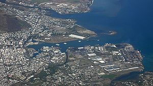 |
|
| 2. | Ebene City Ebene City Ebene City is a city on the island nation of Mauritius, 15 km south of the capital, Port Louis.Construction began in November, 2001, with the city being promoted as a new information technology hub for Mauritius and as a link between African and Asian markets -- as a result is referred to as Ebene... |
20.241892°N 57.491763°W | Plaines Wilhems Plaines Wilhems Plaines Wilhems is one of the most important districts in Mauritius. It has most of the major towns of the country, like Quatre-Bornes, Vacoas-Phœnix, Rose Hill etc. It is divided into Upper Plaine Wilhems and Lower Plaine Wilhems... |
||
| Total |
Towns
| No | |Coordinates Geographic coordinate system A geographic coordinate system is a coordinate system that enables every location on the Earth to be specified by a set of numbers. The coordinates are often chosen such that one of the numbers represent vertical position, and two or three of the numbers represent horizontal position... | |District | | Image | ||
|---|---|---|---|---|---|
| 1. | Beau Bassin - Rose Hill | 20.23°N 57.46°W | Plaines Wilhems Plaines Wilhems Plaines Wilhems is one of the most important districts in Mauritius. It has most of the major towns of the country, like Quatre-Bornes, Vacoas-Phœnix, Rose Hill etc. It is divided into Upper Plaine Wilhems and Lower Plaine Wilhems... |
||
| 2. | Curepipe Curepipe Curepipe is a town centrally situated in Mauritius, an island country in the southwest Indian Ocean. It is second in size and importance to Port Louis, the capital.... |
20.31°N 57.51°W | Plaines Wilhems Plaines Wilhems Plaines Wilhems is one of the most important districts in Mauritius. It has most of the major towns of the country, like Quatre-Bornes, Vacoas-Phœnix, Rose Hill etc. It is divided into Upper Plaine Wilhems and Lower Plaine Wilhems... |
||
| 3. | Quatre-Bornes Quatre Bornes Quatre Bornes is a town in Mauritius, located in the Upper Plaines Wilhems District, between the towns of Rose Hill and Vacoas-Phoenix. Covering an area of over twenty thousand square kilometres, Quatre Bornes is linked by roads to the north, east, south and west of Mauritius... |
20.26°N 57.47°W | Plaines Wilhems Plaines Wilhems Plaines Wilhems is one of the most important districts in Mauritius. It has most of the major towns of the country, like Quatre-Bornes, Vacoas-Phœnix, Rose Hill etc. It is divided into Upper Plaine Wilhems and Lower Plaine Wilhems... |
||
| 4. | Vacoas-Phoenix | 20.30°N 57.48°W | Plaines Wilhems Plaines Wilhems Plaines Wilhems is one of the most important districts in Mauritius. It has most of the major towns of the country, like Quatre-Bornes, Vacoas-Phœnix, Rose Hill etc. It is divided into Upper Plaine Wilhems and Lower Plaine Wilhems... |
||
| Total |
Villages
This is a complete list of all 124 villages in Mauritius.| No | |Coordinates Geographic coordinate system A geographic coordinate system is a coordinate system that enables every location on the Earth to be specified by a set of numbers. The coordinates are often chosen such that one of the numbers represent vertical position, and two or three of the numbers represent horizontal position... | |District | ||
|---|---|---|---|---|
| 1. | Albion | 20.19°N 57.40°W | Black River Black River (district) Black River is a district of Mauritius on the western side of the island. Famous areas include Tamarin Falls and the Chamarel coloured earth. The district capital is Bambous. Previously it was Tamarin. It is the third largest District of Mauritius in area, but the smallest in terms of population... |
|
| 2. | Amaury | 20.14°N 57.68°W | Rivière du Rempart | |
| 3. | Amitié - Gokhoola | 20.12°N 57.67°W | Rivière du Rempart | |
| 4. | Arsenal | 20.09°N 57.53°W | Pamplemousses | |
| 5. | Baie du Cap | Savanne Savanne Savanne is a district in Mauritius. The capital is Souillac. As of the 2000 census, the district has a population of 66,356 and covers an area of 243 km².The south of Mauritius is one of the most scenic and unspoilt parts of the island... |
||
| 6. | Baie du Tombeau Baie du Tombeau Baie du Tombeau is a bay in northwestern Mauritius, formed at the mouth of the Rivière du Tombeau. The bay is located six kilometres to the north of the nation's capital, Port Louis.... |
20.11°N 57.51°W | Pamplemousses | |
| 7. | Bambous | 20.25°N 57.40°W | Black River Black River (district) Black River is a district of Mauritius on the western side of the island. Famous areas include Tamarin Falls and the Chamarel coloured earth. The district capital is Bambous. Previously it was Tamarin. It is the third largest District of Mauritius in area, but the smallest in terms of population... |
|
| 8. | Bambous Virieux | 20.33°N 57.76°W | Grand Port Grand Port Grand Port is a district encompassing much of the south-eastern part of the island of Mauritius. Its capital is Rose-Belle but the most important town of the district is Mahebourg... |
|
| 9. | Bananes | 20.35°N 57.56°W | Grand Port Grand Port Grand Port is a district encompassing much of the south-eastern part of the island of Mauritius. Its capital is Rose-Belle but the most important town of the district is Mahebourg... |
|
| 10. | Beau Vallon | 20.42°N 57.70°W | Grand Port Grand Port Grand Port is a district encompassing much of the south-eastern part of the island of Mauritius. Its capital is Rose-Belle but the most important town of the district is Mahebourg... |
|
| 11. | Bel Air Rivière Sèche | 20.25°N 57.75°W | Flacq Flacq Flacq is a district of Mauritius, situated in the east of the island. The capital is Centre de Flacq. It is the largest district, having an area of 298 km², and as of 2000 has a population of 126,839.... |
|
| 12. | Bel Ombre | Savanne Savanne Savanne is a district in Mauritius. The capital is Souillac. As of the 2000 census, the district has a population of 66,356 and covers an area of 243 km².The south of Mauritius is one of the most scenic and unspoilt parts of the island... |
||
| 13. | Belle Vue Maurel | 20.07°N 57.58°W | Rivière du Rempart | |
| 14. | Bénarès | Savanne Savanne Savanne is a district in Mauritius. The capital is Souillac. As of the 2000 census, the district has a population of 66,356 and covers an area of 243 km².The south of Mauritius is one of the most scenic and unspoilt parts of the island... |
||
| 15. | Bois Chéri | Savanne Savanne Savanne is a district in Mauritius. The capital is Souillac. As of the 2000 census, the district has a population of 66,356 and covers an area of 243 km².The south of Mauritius is one of the most scenic and unspoilt parts of the island... |
||
| 16. | Bois des Amourettes | 20.36°N 57.73°W | Grand Port Grand Port Grand Port is a district encompassing much of the south-eastern part of the island of Mauritius. Its capital is Rose-Belle but the most important town of the district is Mahebourg... |
|
| 17. | Bon Accueil | 20.17°N 57.67°W | Flacq Flacq Flacq is a district of Mauritius, situated in the east of the island. The capital is Centre de Flacq. It is the largest district, having an area of 298 km², and as of 2000 has a population of 126,839.... |
|
| 18. | Brisée Verdière | 20.18°N 57.67°W | Flacq Flacq Flacq is a district of Mauritius, situated in the east of the island. The capital is Centre de Flacq. It is the largest district, having an area of 298 km², and as of 2000 has a population of 126,839.... |
|
| 19. | Britannia | Savanne Savanne Savanne is a district in Mauritius. The capital is Souillac. As of the 2000 census, the district has a population of 66,356 and covers an area of 243 km².The south of Mauritius is one of the most scenic and unspoilt parts of the island... |
||
| 20. | Calebasses | 20.11°N 57.55°W | Pamplemousses | |
| 21. | Camp de Masque | 20.24°N 57.66°W | Flacq Flacq Flacq is a district of Mauritius, situated in the east of the island. The capital is Centre de Flacq. It is the largest district, having an area of 298 km², and as of 2000 has a population of 126,839.... |
|
| 22. | Camp de Masque Pavé | 20.25°N 57.67°W | Flacq Flacq Flacq is a district of Mauritius, situated in the east of the island. The capital is Centre de Flacq. It is the largest district, having an area of 298 km², and as of 2000 has a population of 126,839.... |
|
| 23. | Camp Diable | 20.47°N 57.58°W | Savanne Savanne Savanne is a district in Mauritius. The capital is Souillac. As of the 2000 census, the district has a population of 66,356 and covers an area of 243 km².The south of Mauritius is one of the most scenic and unspoilt parts of the island... |
|
| 24. | Camp Ithier | 20.22°N 57.74°W | Flacq Flacq Flacq is a district of Mauritius, situated in the east of the island. The capital is Centre de Flacq. It is the largest district, having an area of 298 km², and as of 2000 has a population of 126,839.... |
|
| 25. | Camp Thorel | 20.21°N 57.62°W | Moka Moka (district) Moka is a district of Mauritius in the central plateau of the island. The capital is named Quartier Militaire. Moka is also one of the two landlocked districts in Mauritius, the other is Plaines Wilhems. It has Latitude of 20° 13' 0S, and a Longitude of 57° 30' 0E . Its altitude is 698 ft... |
|
| 26. | Cap Malheureux | 19.97°N 57.62°W | Rivière du Rempart | |
| 27. | Cascavelle | 20.27°N 57.40°W | Black River Black River (district) Black River is a district of Mauritius on the western side of the island. Famous areas include Tamarin Falls and the Chamarel coloured earth. The district capital is Bambous. Previously it was Tamarin. It is the third largest District of Mauritius in area, but the smallest in terms of population... |
|
| 28. | Case Noyale | 20.39°N 57.37°W | Black River Black River (district) Black River is a district of Mauritius on the western side of the island. Famous areas include Tamarin Falls and the Chamarel coloured earth. The district capital is Bambous. Previously it was Tamarin. It is the third largest District of Mauritius in area, but the smallest in terms of population... |
|
| 29. | Centre de Flacq Centre de Flacq Centre de Flacq is a town and the capital of the district of Flacq in east-central Mauritius. It is located at an altitude of 154 feet . Flacq is connected to the road that links with the capital city of Port Louis and provides access to the coastal road... |
20.20°N 57.71°W | Flacq Flacq Flacq is a district of Mauritius, situated in the east of the island. The capital is Centre de Flacq. It is the largest district, having an area of 298 km², and as of 2000 has a population of 126,839.... |
|
| 30. | Chamarel Chamarel Chamarel is village in the southwest of Mauritius with a population of 700. It is is named after the frenchman Charles Antoine de Chazal de Chamarel, who lived in the area around 1800.... |
20.41°N 57.38°W | Black River Black River (district) Black River is a district of Mauritius on the western side of the island. Famous areas include Tamarin Falls and the Chamarel coloured earth. The district capital is Bambous. Previously it was Tamarin. It is the third largest District of Mauritius in area, but the smallest in terms of population... |
|
| 31. | Chamouny | 20.48°N 57.45°W | Savanne Savanne Savanne is a district in Mauritius. The capital is Souillac. As of the 2000 census, the district has a population of 66,356 and covers an area of 243 km².The south of Mauritius is one of the most scenic and unspoilt parts of the island... |
|
| 32. | Chemin Grenier | 20.49°N 57.46°W | Savanne Savanne Savanne is a district in Mauritius. The capital is Souillac. As of the 2000 census, the district has a population of 66,356 and covers an area of 243 km².The south of Mauritius is one of the most scenic and unspoilt parts of the island... |
|
| 33. | Clémencia Clemencia Clemencia is a town and municipality located in the Bolívar Department, northern Colombia.... |
20.26°N 57.70°W | Flacq Flacq Flacq is a district of Mauritius, situated in the east of the island. The capital is Centre de Flacq. It is the largest district, having an area of 298 km², and as of 2000 has a population of 126,839.... |
|
| 34. | Cluny | 20.37°N 57.60°W | Grand Port Grand Port Grand Port is a district encompassing much of the south-eastern part of the island of Mauritius. Its capital is Rose-Belle but the most important town of the district is Mahebourg... |
|
| 35. | Congomah | 20.14°N 57.58°W | Pamplemousses | |
| 36. | Cottage | 20.05°N 57.62°W | Rivière du Rempart | |
| 37. | Crève Coeur | 20.17°N 57.55°W | Pamplemousses | |
| 38. | D'Épinay | 20.13°N 57.59°W | Pamplemousses | |
| 39. | Dagotière | 20.23°N 57.55°W | Moka Moka (district) Moka is a district of Mauritius in the central plateau of the island. The capital is named Quartier Militaire. Moka is also one of the two landlocked districts in Mauritius, the other is Plaines Wilhems. It has Latitude of 20° 13' 0S, and a Longitude of 57° 30' 0E . Its altitude is 698 ft... |
|
| 40. | Dubreuil | 20.30°N 57.59°W | Moka Moka (district) Moka is a district of Mauritius in the central plateau of the island. The capital is named Quartier Militaire. Moka is also one of the two landlocked districts in Mauritius, the other is Plaines Wilhems. It has Latitude of 20° 13' 0S, and a Longitude of 57° 30' 0E . Its altitude is 698 ft... |
|
| 41. | Écroignard | 20.23°N 57.74°W | Flacq Flacq Flacq is a district of Mauritius, situated in the east of the island. The capital is Centre de Flacq. It is the largest district, having an area of 298 km², and as of 2000 has a population of 126,839.... |
|
| 42. | Espérance | Moka Moka (district) Moka is a district of Mauritius in the central plateau of the island. The capital is named Quartier Militaire. Moka is also one of the two landlocked districts in Mauritius, the other is Plaines Wilhems. It has Latitude of 20° 13' 0S, and a Longitude of 57° 30' 0E . Its altitude is 698 ft... |
||
| 43. | Espérance Trébuchet | 20.07°N 57.64°W | Rivière du Rempart | |
| 44. | Flic en Flac Flic en Flac Flic en Flac has become the second tourist area of Mauritius after Grand Baie. From a small fishing village, over the past 200 years, it has rapidly developed into an important tourist area.-History:... |
20.27°N 57.37°W | Black River Black River (district) Black River is a district of Mauritius on the western side of the island. Famous areas include Tamarin Falls and the Chamarel coloured earth. The district capital is Bambous. Previously it was Tamarin. It is the third largest District of Mauritius in area, but the smallest in terms of population... |
|
| 45. | Fond du Sac Fond du Sac Fond du Sac is a village in the northern part of the island of Mauritius. It is found in the district of Pamplemousses.Fond du Sac is linked with the roads leading to the capital, Port Louis and to the villages of Flacq and Mahébourg. To some, Fond du Sac is also known as 'Kasmakaya' and gained... |
20.05°N 57.57°W | Pamplemousses | |
| 46. | Goodlands | 20.03°N 57.63°W | Rivière du Rempart | |
| 47. | Grand Baie Grand Baie Grand Baie, is a seaside village and large tourist beach in the district of Rivière du Rempart on the island of Mauritius. The village is on the western side of the northernmost point of Mauritius and was the site of the British Invasion of Île de France in November 1810.Grand Baie may well be the... |
20.02°N 57.58°W | Rivière du Rempart | |
| 48. | Grand Bel Air | 20.50°N 57.57°W | Grand Port Grand Port Grand Port is a district encompassing much of the south-eastern part of the island of Mauritius. Its capital is Rose-Belle but the most important town of the district is Mahebourg... |
|
| 49. | Grand Bois | 20.42°N 57.55°W | Savanne Savanne Savanne is a district in Mauritius. The capital is Souillac. As of the 2000 census, the district has a population of 66,356 and covers an area of 243 km².The south of Mauritius is one of the most scenic and unspoilt parts of the island... |
|
| 50. | Grand Gaube Grand Gaube Grand Gaube is a town located in the Rivière du Rempart District, northern Mauritius. It lies on the coast of the Indian Ocean. In the 60's and 70's its population was exclusively the Mauritian Creoles and Indo Mauritians, a handful of Franco Mauritians and three shop-keepers Chinese families... |
20.02°N 57.65°W | Rivière du Rempart | |
| 51. | Grand River South East | 20.27°N 57.77°W | Flacq Flacq Flacq is a district of Mauritius, situated in the east of the island. The capital is Centre de Flacq. It is the largest district, having an area of 298 km², and as of 2000 has a population of 126,839.... |
|
| 52. | Grand Sable | 20.31°N 57.77°W | Grand Port Grand Port Grand Port is a district encompassing much of the south-eastern part of the island of Mauritius. Its capital is Rose-Belle but the most important town of the district is Mahebourg... |
|
| 53. | Grande Rivière Noire | 20.34°N 57.37°W | Black River Black River (district) Black River is a district of Mauritius on the western side of the island. Famous areas include Tamarin Falls and the Chamarel coloured earth. The district capital is Bambous. Previously it was Tamarin. It is the third largest District of Mauritius in area, but the smallest in terms of population... |
|
| 54. | Gros Cailloux | 20.20°N 57.43°W | Black River Black River (district) Black River is a district of Mauritius on the western side of the island. Famous areas include Tamarin Falls and the Chamarel coloured earth. The district capital is Bambous. Previously it was Tamarin. It is the third largest District of Mauritius in area, but the smallest in terms of population... |
|
| 55. | L'Avenir | 20.21°N 57.55°W | Moka Moka (district) Moka is a district of Mauritius in the central plateau of the island. The capital is named Quartier Militaire. Moka is also one of the two landlocked districts in Mauritius, the other is Plaines Wilhems. It has Latitude of 20° 13' 0S, and a Longitude of 57° 30' 0E . Its altitude is 698 ft... |
|
| 56. | L'Escalier | 20.47°N 57.60°W | Grand Port Grand Port Grand Port is a district encompassing much of the south-eastern part of the island of Mauritius. Its capital is Rose-Belle but the most important town of the district is Mahebourg... |
|
| 57. | La Gaulette | Black River Black River (district) Black River is a district of Mauritius on the western side of the island. Famous areas include Tamarin Falls and the Chamarel coloured earth. The district capital is Bambous. Previously it was Tamarin. It is the third largest District of Mauritius in area, but the smallest in terms of population... |
||
| 58. | La Laura - Malenga | 20.20°N 57.55°W | Moka Moka (district) Moka is a district of Mauritius in the central plateau of the island. The capital is named Quartier Militaire. Moka is also one of the two landlocked districts in Mauritius, the other is Plaines Wilhems. It has Latitude of 20° 13' 0S, and a Longitude of 57° 30' 0E . Its altitude is 698 ft... |
|
| 59. | Lalmatie | 20.20°N 57.67°W | Flacq Flacq Flacq is a district of Mauritius, situated in the east of the island. The capital is Centre de Flacq. It is the largest district, having an area of 298 km², and as of 2000 has a population of 126,839.... |
|
| 60. | Laventure | 20.15°N 57.68°W | Flacq Flacq Flacq is a district of Mauritius, situated in the east of the island. The capital is Centre de Flacq. It is the largest district, having an area of 298 km², and as of 2000 has a population of 126,839.... |
|
| 61. | Le Hochet | 20.14°N 57.53°W | Pamplemousses | |
| 62. | Le Morne | 20.45°N 57.34°W | Black River Black River (district) Black River is a district of Mauritius on the western side of the island. Famous areas include Tamarin Falls and the Chamarel coloured earth. The district capital is Bambous. Previously it was Tamarin. It is the third largest District of Mauritius in area, but the smallest in terms of population... |
|
| 63. | Long Mountain | 20.13°N 57.57°W | Pamplemousses | |
| 64. | Mahébourg Mahébourg Mahébourg is a small city on the southeastern coast of the island of Mauritius. It is the capital of the Grand Port District.- Overview :... |
20.41°N 57.70°W | Grand Port Grand Port Grand Port is a district encompassing much of the south-eastern part of the island of Mauritius. Its capital is Rose-Belle but the most important town of the district is Mahebourg... |
|
| 65. | Mapou Mapou For the tree of the same name see MatipoMapou is a village in the northern part of the island of Mauritius. It serves the district capital of Rivière du Rempart. The island are linked with the coastal road as well as a road to Triolet and Port Louis. the village also has a post office, a primary... |
20.08°N 57.61°W | Rivière du Rempart | |
| 66. | Mare Chicose | Grand Port Grand Port Grand Port is a district encompassing much of the south-eastern part of the island of Mauritius. Its capital is Rose-Belle but the most important town of the district is Mahebourg... |
||
| 67. | Mare d'Albert | Grand Port Grand Port Grand Port is a district encompassing much of the south-eastern part of the island of Mauritius. Its capital is Rose-Belle but the most important town of the district is Mahebourg... |
||
| 68. | Mare La Chaux | 20.20°N 57.76°W | Flacq Flacq Flacq is a district of Mauritius, situated in the east of the island. The capital is Centre de Flacq. It is the largest district, having an area of 298 km², and as of 2000 has a population of 126,839.... |
|
| 69. | Mare Tabac | Grand Port Grand Port Grand Port is a district encompassing much of the south-eastern part of the island of Mauritius. Its capital is Rose-Belle but the most important town of the district is Mahebourg... |
||
| 70. | Médine (Camp de Masque) | Flacq Flacq Flacq is a district of Mauritius, situated in the east of the island. The capital is Centre de Flacq. It is the largest district, having an area of 298 km², and as of 2000 has a population of 126,839.... |
||
| 71. | Melrose | 20.26°N 57.63°W | Moka Moka (district) Moka is a district of Mauritius in the central plateau of the island. The capital is named Quartier Militaire. Moka is also one of the two landlocked districts in Mauritius, the other is Plaines Wilhems. It has Latitude of 20° 13' 0S, and a Longitude of 57° 30' 0E . Its altitude is 698 ft... |
|
| 72. | Midlands Midlands, Mauritius Midlands is a small village in Mauritius situated approximately half way between Nouvelle France and Curepipe on the M2 motorway. Midlands is on the highlands of the island at approximately 386 metres.... |
20.32°N 57.57°W | Plaines Wilhems Plaines Wilhems Plaines Wilhems is one of the most important districts in Mauritius. It has most of the major towns of the country, like Quatre-Bornes, Vacoas-Phœnix, Rose Hill etc. It is divided into Upper Plaine Wilhems and Lower Plaine Wilhems... |
|
| 73. | Moka Moka Moka is a town in Mauritius. It's also the home to the University of Mauritius, the Mahatma Gandhi Institute and the Mauritius Broadcasting Corporation.... |
20.21°N 57.50°W | Moka Moka (district) Moka is a district of Mauritius in the central plateau of the island. The capital is named Quartier Militaire. Moka is also one of the two landlocked districts in Mauritius, the other is Plaines Wilhems. It has Latitude of 20° 13' 0S, and a Longitude of 57° 30' 0E . Its altitude is 698 ft... |
|
| 74. | Montagne Blanche | 20.29°N 57.65°W | Moka Moka (district) Moka is a district of Mauritius in the central plateau of the island. The capital is named Quartier Militaire. Moka is also one of the two landlocked districts in Mauritius, the other is Plaines Wilhems. It has Latitude of 20° 13' 0S, and a Longitude of 57° 30' 0E . Its altitude is 698 ft... |
|
| 75. | Morcellement St. André | 20.08°N 57.55°W | Pamplemousses | |
| 76. | New Grove | 20.42°N 57.60°W | Grand Port Grand Port Grand Port is a district encompassing much of the south-eastern part of the island of Mauritius. Its capital is Rose-Belle but the most important town of the district is Mahebourg... |
|
| 77. | Notre Dame | 20.15°N 57.57°W | Pamplemousses | |
| 78. | Nouvelle France | 20.37°N 57.55°W | Grand Port Grand Port Grand Port is a district encompassing much of the south-eastern part of the island of Mauritius. Its capital is Rose-Belle but the most important town of the district is Mahebourg... |
|
| 79. | Old Grand Port | Grand Port Grand Port Grand Port is a district encompassing much of the south-eastern part of the island of Mauritius. Its capital is Rose-Belle but the most important town of the district is Mahebourg... |
||
| 80. | Olivia | 20.29°N 57.73°W | Flacq Flacq Flacq is a district of Mauritius, situated in the east of the island. The capital is Centre de Flacq. It is the largest district, having an area of 298 km², and as of 2000 has a population of 126,839.... |
|
| 81. | Pailles | 20.18°N 57.46°W | Moka Moka (district) Moka is a district of Mauritius in the central plateau of the island. The capital is named Quartier Militaire. Moka is also one of the two landlocked districts in Mauritius, the other is Plaines Wilhems. It has Latitude of 20° 13' 0S, and a Longitude of 57° 30' 0E . Its altitude is 698 ft... |
|
| 82. | Pamplemousses | 20.10°N 57.57°W | Pamplemousses | |
| 83. | Petit Bel Air | Grand Port Grand Port Grand Port is a district encompassing much of the south-eastern part of the island of Mauritius. Its capital is Rose-Belle but the most important town of the district is Mahebourg... |
||
| 84. | Petit Raffray | 20.00°N 57.58°W | Rivière du Rempart | |
| 85. | Petite Rivière | 20.18°N 57.43°W | Black River Black River (district) Black River is a district of Mauritius on the western side of the island. Famous areas include Tamarin Falls and the Chamarel coloured earth. The district capital is Bambous. Previously it was Tamarin. It is the third largest District of Mauritius in area, but the smallest in terms of population... |
|
| 86. | Piton | 20.09°N 57.62°W | Rivière du Rempart | |
| 87. | Plaine des Papayes | 20.07°N 57.57°W | Pamplemousses | |
| 88. | Plaine des Roches | 20.12°N 57.70°W | Rivière du Rempart | |
| 89. | Plaine Magnien | 20.43°N 57.65°W | Grand Port Grand Port Grand Port is a district encompassing much of the south-eastern part of the island of Mauritius. Its capital is Rose-Belle but the most important town of the district is Mahebourg... |
|
| 90. | Pointe aux Piments | 20.08°N 57.51°W | Pamplemousses | |
| 91. | Poste de Flacq | 20.17°N 57.71°W | Flacq Flacq Flacq is a district of Mauritius, situated in the east of the island. The capital is Centre de Flacq. It is the largest district, having an area of 298 km², and as of 2000 has a population of 126,839.... |
|
| 92. | Poudre d'Or | 20.06°N 57.67°W | Rivière du Rempart | |
| 93. | Poudre d'Or Hamlet | 20.05°N 57.67°W | Rivière du Rempart | |
| 94. | Providence | 20.24°N 57.62°W | Moka Moka (district) Moka is a district of Mauritius in the central plateau of the island. The capital is named Quartier Militaire. Moka is also one of the two landlocked districts in Mauritius, the other is Plaines Wilhems. It has Latitude of 20° 13' 0S, and a Longitude of 57° 30' 0E . Its altitude is 698 ft... |
|
| 95. | Quartier Militaire Quartier Militaire Quartier Militaire is a town found in the centre of Mauritius, found in the Moka District and the capital of the Garden District. It houses the District Council of the region. It has a population of over 30,600... |
20.25°N 57.58°W | Moka Moka (district) Moka is a district of Mauritius in the central plateau of the island. The capital is named Quartier Militaire. Moka is also one of the two landlocked districts in Mauritius, the other is Plaines Wilhems. It has Latitude of 20° 13' 0S, and a Longitude of 57° 30' 0E . Its altitude is 698 ft... |
|
| 96. | Quatre Cocos | 20.23°N 57.79°W | Flacq Flacq Flacq is a district of Mauritius, situated in the east of the island. The capital is Centre de Flacq. It is the largest district, having an area of 298 km², and as of 2000 has a population of 126,839.... |
|
| 97. | Quatre Soeurs | 20.29°N 57.77°W | Flacq Flacq Flacq is a district of Mauritius, situated in the east of the island. The capital is Centre de Flacq. It is the largest district, having an area of 298 km², and as of 2000 has a population of 126,839.... |
|
| 98. | Queen Victoria | 20.21°N 57.70°W | Flacq Flacq Flacq is a district of Mauritius, situated in the east of the island. The capital is Centre de Flacq. It is the largest district, having an area of 298 km², and as of 2000 has a population of 126,839.... |
|
| 99. | Richelieu | 20.19°N 57.45°W | Black River Black River (district) Black River is a district of Mauritius on the western side of the island. Famous areas include Tamarin Falls and the Chamarel coloured earth. The district capital is Bambous. Previously it was Tamarin. It is the third largest District of Mauritius in area, but the smallest in terms of population... |
|
| 100. | Ripailles | Moka Moka (district) Moka is a district of Mauritius in the central plateau of the island. The capital is named Quartier Militaire. Moka is also one of the two landlocked districts in Mauritius, the other is Plaines Wilhems. It has Latitude of 20° 13' 0S, and a Longitude of 57° 30' 0E . Its altitude is 698 ft... |
||
| 101. | Rivière des Anguilles | 20.48°N 57.55°W | Savanne Savanne Savanne is a district in Mauritius. The capital is Souillac. As of the 2000 census, the district has a population of 66,356 and covers an area of 243 km².The south of Mauritius is one of the most scenic and unspoilt parts of the island... |
|
| 102. | Rivière des Créoles Rivière des Créoles Rivière des Créoles is a river in southeastern Mauritius. It flows southeast for 13 kilometres, reaching the Indian Ocean close to the city of Mahébourg.... |
Grand Port Grand Port Grand Port is a district encompassing much of the south-eastern part of the island of Mauritius. Its capital is Rose-Belle but the most important town of the district is Mahebourg... |
||
| 103. | Rivière du Poste | Grand Port Grand Port Grand Port is a district encompassing much of the south-eastern part of the island of Mauritius. Its capital is Rose-Belle but the most important town of the district is Mahebourg... |
||
| 104. | Rivière du Rempart | 20.10°N 57.68°W | Rivière du Rempart | |
| 105. | Roches Noires | 20.11°N 57.72°W | Rivière du Rempart | |
| 106. | Roche Terre | 20.01°N 57.62°W | Rivière du Rempart | |
| 107. | Rose Belle | 20.40°N 57.60°W | Grand Port Grand Port Grand Port is a district encompassing much of the south-eastern part of the island of Mauritius. Its capital is Rose-Belle but the most important town of the district is Mahebourg... |
|
| 108. | Sébastopol Sebastopol Sebastopol is a former spelling and frequent variant of Sevastopol, the port on the Crimean peninsula.Sebastopol may refer to the following:Places:* Sebastopol, California, USA* Sebastopol, Mississippi, USA... |
20.28°N 57.68°W | Flacq Flacq Flacq is a district of Mauritius, situated in the east of the island. The capital is Centre de Flacq. It is the largest district, having an area of 298 km², and as of 2000 has a population of 126,839.... |
|
| 109. | Souillac Souillac, Mauritius Souillac is a village close to the southernmost point of the main island of Mauritius. It is the capital of Savanne district. It was named after the Vicomte de Souillac, the island's governor from 1779-1787.-History:... |
20.51°N 57.51°W | Savanne Savanne Savanne is a district in Mauritius. The capital is Souillac. As of the 2000 census, the district has a population of 66,356 and covers an area of 243 km².The south of Mauritius is one of the most scenic and unspoilt parts of the island... |
|
| 110. | St. Aubin | 20.49°N 57.53°W | Savanne Savanne Savanne is a district in Mauritius. The capital is Souillac. As of the 2000 census, the district has a population of 66,356 and covers an area of 243 km².The south of Mauritius is one of the most scenic and unspoilt parts of the island... |
|
| 111. | St. Hubert | 20.37°N 57.63°W | Grand Port Grand Port Grand Port is a district encompassing much of the south-eastern part of the island of Mauritius. Its capital is Rose-Belle but the most important town of the district is Mahebourg... |
|
| 112. | St. Julien (Haut de Flacq) | 20.22°N 57.63°W | Flacq Flacq Flacq is a district of Mauritius, situated in the east of the island. The capital is Centre de Flacq. It is the largest district, having an area of 298 km², and as of 2000 has a population of 126,839.... |
|
| 113. | St. Julien d'Hotman | 20.23°N 57.63°W | Flacq Flacq Flacq is a district of Mauritius, situated in the east of the island. The capital is Centre de Flacq. It is the largest district, having an area of 298 km², and as of 2000 has a population of 126,839.... |
|
| 114. | St. Pierre St. Pierre, Mauritius St. Pierre is a town in the district of Moka in Mauritius.... |
20.22°N 57.52°W | Moka Moka (district) Moka is a district of Mauritius in the central plateau of the island. The capital is named Quartier Militaire. Moka is also one of the two landlocked districts in Mauritius, the other is Plaines Wilhems. It has Latitude of 20° 13' 0S, and a Longitude of 57° 30' 0E . Its altitude is 698 ft... |
|
| 115. | Surinam | 20.50°N 57.48°W | Savanne Savanne Savanne is a district in Mauritius. The capital is Souillac. As of the 2000 census, the district has a population of 66,356 and covers an area of 243 km².The south of Mauritius is one of the most scenic and unspoilt parts of the island... |
|
| 116. | Tamarin Tamarin, Mauritius Tamarin is a village on the western coast of Mauritius. It has long been the seat of the council district of Black River.Recently the district council has been moved to new headquarters in Bambous, this village being more accessible to the villagers.... |
20.31°N 57.38°W | Black River Black River (district) Black River is a district of Mauritius on the western side of the island. Famous areas include Tamarin Falls and the Chamarel coloured earth. The district capital is Bambous. Previously it was Tamarin. It is the third largest District of Mauritius in area, but the smallest in terms of population... |
|
| 117. | Terre Rouge | 20.12°N 57.52°W | Pamplemousses | |
| 118. | The Vale | 20.01°N 57.58°W | Rivière du Rempart | |
| 119. | Triolet Triolet, Mauritius - Location :Triolet is a small town on the island of Mauritius. It serves the district capital of Pamplemousses. It lies exactly 7 miles from Port Louis, the capital of the island. The village is a patch of civilisation amid green sugarcane fields, near the north-western coast of the island... |
20.05°N 57.53°W | Pamplemousses | |
| 120. | Trois Boutiques | Grand Port Grand Port Grand Port is a district encompassing much of the south-eastern part of the island of Mauritius. Its capital is Rose-Belle but the most important town of the district is Mahebourg... |
||
| 121. | Trou d'Eau Douce | 20.23°N 57.78°W | Flacq Flacq Flacq is a district of Mauritius, situated in the east of the island. The capital is Centre de Flacq. It is the largest district, having an area of 298 km², and as of 2000 has a population of 126,839.... |
|
| 122. | Union Park | Grand Port Grand Port Grand Port is a district encompassing much of the south-eastern part of the island of Mauritius. Its capital is Rose-Belle but the most important town of the district is Mahebourg... |
||
| 123. | Verdun | 20.22°N 57.55°W | Moka Moka (district) Moka is a district of Mauritius in the central plateau of the island. The capital is named Quartier Militaire. Moka is also one of the two landlocked districts in Mauritius, the other is Plaines Wilhems. It has Latitude of 20° 13' 0S, and a Longitude of 57° 30' 0E . Its altitude is 698 ft... |
|
| 124. | Villebague | 20.12°N 57.62°W | Pamplemousses | |
| Total |
Rodrigues IslandRodriguesRodrigues is a common surname in the Portuguese language. It was originally a Patronymic, meaning Son of Rodrigo or Son of Rui. The "es" signifies "son of". The name Rodrigo is the Portuguese form of Roderick, meaning "famous power" or "famous ruler", from the Germanic elements "hrod" and "ric" ,...
Rodrigues has 14 municipalities or zones:| No | |Coordinates Geographic coordinate system A geographic coordinate system is a coordinate system that enables every location on the Earth to be specified by a set of numbers. The coordinates are often chosen such that one of the numbers represent vertical position, and two or three of the numbers represent horizontal position... | 1. | Baie Malgache |
|---|---|---|---|
| 2. | Coromandel - Graviers | ||
| 3. | Grand Baie - Montagne Goyaves | ||
| 4. | La Ferme | ||
| 5. | Lataniers - Mont Lubin | ||
| 6. | Mangues - Quatre Vents | ||
| 7. | Oyster Bay (Baie aux Huîtres) | 19.73°N 63.36°W | |
| 8. | Petit Gabriel | ||
| 9. | Piments - Baie Topaze | ||
| 10. | Plaine Corail - La Fouche Corail | ||
| 11. | Port Mathurin Port Mathurin The village of Port Mathurin serves as the capital of the island of Rodrigues, a dependency of Mauritius. It lies on the north coast of the Indian-Ocean island and functions as the administrative, judicial and economic centre of Rodrigues. As the name suggests, it also operates the main harbour of... |
19.68°N 63.42°W | |
| 12. | Port Sud-Est | ||
| 13. | Rivière Cocos | ||
| 14. | Roche Bon Dieu - Trèfles | ||
| Total |
For statistical purposes, the zones are further subdivided into a total of 182 localities. Each zones have a minimum of six localities.
Agalega Islands
| No | |Coordinates Geographic coordinate system A geographic coordinate system is a coordinate system that enables every location on the Earth to be specified by a set of numbers. The coordinates are often chosen such that one of the numbers represent vertical position, and two or three of the numbers represent horizontal position... | |Regions | ||
|---|---|---|---|---|
| 1. | La Fourche | North Island | ||
| 2. | Sainte Rita | South Island | ||
| 3. | Vingt Cinq Vingt Cinq Vingt Cinq is the capital of the Agalega Islands, two islands in the Indian Ocean, governed by Mauritius. It is located on the North Island. In the town, there is a church, a school, and a hospital.... |
10.388°N 56.619°W | North Island | |
| Total |