
List of census-designated places in Oklahoma
Encyclopedia
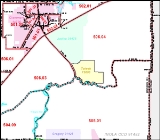
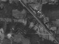
| Images of the Tiawah CDP and of the actual community |
 |
 |
The list of Census Designated Places in Oklahoma contains those areas defined by the US Census Bureau as CDP
Census-designated place
A census-designated place is a concentration of population identified by the United States Census Bureau for statistical purposes. CDPs are delineated for each decennial census as the statistical counterparts of incorporated places such as cities, towns and villages...
s. A CDP is a "statistical entity ... comprising a densely settled concentration of population that is not within an incorporated place..."http://www.census.gov/geo/lv4help/cengeoglos.html. CDPs have no governmental powers. For some reason the CDPs in Oklahoma are all located in the northeastern quarter of the state.
Many of the CDPs were named for communities located within the defined entities, or for nearby communities. Where known, the associated communities are also listed for reference. The sources for the associated communities are primarily from Shirk's Oklahoma Place Names ( ISBN 0-8061-2028-2 ), the United States Geological Survey, or the list of unincorporated communities in Oklahoma.
See also:
B
- BallouBallou, OklahomaBallou is a census-designated place in Mayes County, Oklahoma, United States. As of the 2000 census, the CDP population was 142. It had increased to 176 in the 2010 census.-Geography:Ballou is located at ....
- Mayes County - BelfonteBelfonte, OklahomaBelfonte is a census-designated place in Sequoyah County, Oklahoma, United States. It is part of the Fort Smith, Arkansas-Oklahoma Metropolitan Statistical Area. The population was 426 at the 2000 census.-Geography:...
- Sequoyah County - BellBell, OklahomaBell is a census-designated place in Adair County, Oklahoma, United States. The population was 602 at the 2000 census.-Geography:Bell is located at ....
- Adair County - BrentBrent, OklahomaBrent is a census-designated place in Sequoyah County, Oklahoma, United States, south of Sallisaw. It is part of the Fort Smith, Arkansas-Oklahoma Metropolitan Statistical Area. The population was 504 at the 2000 census....
- Sequoyah County - BriggsBriggs, OklahomaBriggs is a census-designated place in Cherokee County, Oklahoma, in the United States. The population was 358 at the 2000 census. It lies east of Tahlequah, along U.S. Route 62...
- Cherokee County - Brush CreekBrush Creek, OklahomaBrush Creek is a census-designated place in Delaware County, Oklahoma, United States. The population was 41 at the 2000 census.-Geography:Brush Creek is located at ....
- Delaware County - BrushyBrushy, OklahomaBrushy is a census-designated place in Sequoyah County, Oklahoma, United States, along U.S. Route 59 in the foothills of the Brushy Mountains. It is part of the Fort Smith, Arkansas-Oklahoma Metropolitan Statistical Area...
- Sequoyah County - Bull HollowBull Hollow, OklahomaBull Hollow is a census-designated place in Delaware County, Oklahoma, United States. The population was 84 at the 2000 census.-Geography:Bull Hollow is located at ....
- Delaware County - BushyheadBushyhead, OklahomaBushyhead is a census-designated place in Rogers County, Oklahoma, United States. The population was 1,314 at the 2010 census, a 9.2 percent increase from the 1,203 at the 2000 census. Established on the St. Louis-San Francisco Railway between Claremore and Vinita, the community was named for...
- Rogers County
C
- CarlileCarlile, OklahomaCarlile is a census-designated place in Sequoyah County, Oklahoma, United States. It is part of the Fort Smith, Arkansas-Oklahoma Metropolitan Statistical Area...
- Sequoyah County - CayugaCayuga, OklahomaCayuga is a census-designated place in Delaware County, Oklahoma, United States. The population was 105 at the 2000 census.It was established on Elk River in the old Seneca Reserve in Indian Territory...
- Delaware County - Cedar CrestCedar Crest, OklahomaCedar Crest is a census-designated place in Mayes County, Oklahoma, United States. The population was 312 at the 2010 census, almost unchanged from 308 in the 2000 census.-Geography:Cedar Crest is located at ....
- Mayes County - Cherry TreeCherry Tree, OklahomaCherry Tree is a census-designated place in Adair County, Oklahoma, United States. The population was 1,202 at the 2000 census.-Geography:Cherry Tree is located at ....
- Adair County - CheweyChewey, OklahomaChewey is a census-designated place in Adair County, Oklahoma, United States. The population was 135 at the 2000 census.-Geography:Chewey is located at ....
- Adair County - ChristieChristie, OklahomaChristie is a census-designated place in Adair County, Oklahoma, United States. The population was 166 at the 2000 census.-Geography:Christie is located at ....
- Adair County - CleoraCleora, OklahomaCleora is a census-designated place in Delaware County, Oklahoma, United States, along State Highway 85. The population was 1,113 at the 2000 census. The Cleora Post Office existed from November 28, 1900 until October 15, 1954. Cleora was established in District 2 of the old Indian Territory...
- Delaware County - Cloud CreekCloud Creek, OklahomaCloud Creek is a census-designated place in Delaware County, Oklahoma, United States. The population was 86 at the 2000 census.-Geography:Cloud Creek is located at ....
- Delaware County - Copeland - Delaware County
D
- DennisDennis, OklahomaDennis is a census-designated place in Delaware County, Oklahoma, United States, near Grand Lake. The population was 185 at the 2000 census. The Dennis Post Office existed from March 25, 1914, until January 31, 1956...
- Delaware County - DodgeDodge, OklahomaDodge is a census-designated place in Delaware County, Oklahoma, United States. The population was 96 at the 2000 census.The Dodge Post Office existed from November 20, 1901, until August 15, 1941. Dodge was established on Cowskin Prairie along the St...
- Delaware County - DotyvilleDotyville, OklahomaDotyville is a census-designated place in Ottawa County, Oklahoma, United States. The population was 17 at the 2000 census.-Geography:Dotyville is located at .According to the United States Census Bureau, the CDP has a total area of , all of it land....
- Ottawa County - Dripping Springs - Delaware County
- Dry CreekDry Creek, OklahomaDry Creek is a census-designated place in Cherokee County, Oklahoma, United States. The population was 216 at the 2000 census.-Geography:Dry Creek is located at ....
- Cherokee County - Duchess LandingDuchess Landing, OklahomaDuchess Landing is a census-designated place in McIntosh County, Oklahoma, United States. The population was 95 at the 2000 census.-Geography:Duchess Landing is located at ....
- McIntosh County - Dwight MissionDwight Mission, OklahomaDwight Mission is a census-designated place in Sequoyah County, Oklahoma, United States. It is part of the Fort Smith, Arkansas-Oklahoma Metropolitan Statistical Area. The population was 32 at the 2000 census...
- Sequoyah County
E
- EldonEldon, OklahomaEldon is a census-designated place in Cherokee County, Oklahoma, United States. The population was 991 at the 2000 census. It lies east of Tahlequah at the junction of U.S. Highway 62 and State Highway 51. The Eldon Post Office existed from March 20, 1911, until May 30, 1936...
- Cherokee County - Evening ShadeEvening Shade, OklahomaEvening Shade is a census-designated place in Sequoyah County, Oklahoma, United States. It is part of the Fort Smith, Arkansas-Oklahoma Metropolitan Statistical Area...
- Sequoyah County
F
- FairfieldFairfield, OklahomaFairfield is a census-designated place in Adair County, Oklahoma, United States. The population was 367 at the 2000 census.-Geography:Fairfield is located at ....
- Adair County - Flint CreekFlint Creek, OklahomaFlint Creek is a census-designated place in Delaware County, Oklahoma, United States. The population was 580 at the 2000 census.-Geography:Flint Creek is located at ....
- Delaware County - Flute SpringsFlute Springs, OklahomaFlute Springs is a census-designated place in Sequoyah County, Oklahoma, United States. It is part of the Fort Smith, Arkansas-Oklahoma Metropolitan Statistical Area...
- Sequoyah County
L
- LeachLeach, OklahomaLeach is a census-designated place in southwestern Delaware County, Oklahoma, United States, along U.S. Highway 412 Scenic. The population was 220 at the 2000 census.-History:...
- Delaware County - LimestoneLimestone, OklahomaLimestone is a census-designated place in Rogers County, Oklahoma, United States. The population was 745 at the 2000 census.-Geography:Limestone is located at...
- Rogers County - LongLong, OklahomaLong is a census-designated place in Sequoyah County, Oklahoma, United States. It is part of the Fort Smith, Arkansas-Oklahoma Metropolitan Statistical Area. The population was 363 at the 2000 census....
- Sequoyah County - LongtownLongtown, OklahomaLongtown is a census-designated place and unincorporated community in Pittsburg County, Oklahoma, United States. The population was 2,397 at the 2000 census.-Geography:Longtown is located at...
- Pittsburg County - Lost CityLost City, OklahomaLost City is a census-designated place in Cherokee County, Oklahoma, United States. The population was 809 at the 2000 census. It was the site of the first meteorite fall in the US to be recorded by a camera network.-Geography:...
- Cherokee County - Lyons SwitchLyons Switch, OklahomaLyons Switch is a census-designated place in Adair County, Oklahoma, United States. The population was 227 at the 2000 census.-Geography:Lyons Switch is located at ....
- Adair County
M
- Marble City CommunityMarble City Community, OklahomaMarble City Community is a census-designated place in Sequoyah County, Oklahoma, United States. It is part of the Fort Smith, Arkansas-Oklahoma Metropolitan Statistical Area...
- Sequoyah County - MaryettaMaryetta, OklahomaMaryetta is a census-designated place in Adair County, Oklahoma, United States. The population was 138 at the 2000 census.-Geography:Maryetta is located at ....
- Adair County - MazieMazie, OklahomaMazie is a census-designated place in Mayes County, Oklahoma, United States. The population was 91 at the Mazie is a [[census-designated place]] in [[Mayes County, Oklahoma|Mayes County]], [[Oklahoma]], [[United States]]...
- Mayes County - McCordMcCord, OklahomaMcCord is a census-designated place in Osage County, Oklahoma, United States. The population was 1,440 at the 2010 census, a decrease of 15.8 percent from 1,711 at the 2000 census.-Geography:McCord is located at ....
- Osage County - McKeyMcKey, OklahomaMcKey is a census-designated place in Sequoyah County, Oklahoma, United States. It is part of the Fort Smith, Arkansas-Oklahoma Metropolitan Statistical Area. The population was 135 at the 2000 census. McKey was established on the Old Osage and Arkansas Valley Railroad near MacKey's Salt Works...
- Sequoyah County - MeridianMeridian, Stephens County, OklahomaMeridian is a census-designated place in Stephens County, Oklahoma, United States. The population was 1,485 at the 2000 census.-Geography:Meridian is located at...
- Stephens County - MurphyMurphy, OklahomaMurphy is a census-designated place in Mayes County, Oklahoma, United States. The population was 231 at the 2000 census.-Geography:Murphy is located at ....
- Mayes County
N
- NarcissaNarcissa, OklahomaNarcissa is a census-designated place in Ottawa County, Oklahoma, United States. The population was 100 at the 2000 census.-Geography:Narcissa is located at ....
- Ottawa County - New EuchaNew Eucha, OklahomaNew Eucha is a census-designated place in Delaware County, Oklahoma, United States. The population was 300 at the 2000 census.-Geography:New Eucha is located at ....
- Delaware County - NotchietownNotchietown, OklahomaNotchietown is a census-designated place in Sequoyah County, Oklahoma, United States. It is part of the Fort Smith, Arkansas-Oklahoma Metropolitan Statistical Area. The population was 430 at the 2000 census.-Geography:...
- Sequoyah County
P
- Park HillPark Hill, OklahomaPark Hill is a census-designated place in southwestern Cherokee County, Oklahoma in the United States. The population was 3,936 at the 2000 census. It lies near Tahlequah, east of the junction of U.S. Route 62 and State Highway 82.-History:...
- Cherokee County - PeavinePeavine, OklahomaPeavine is a census-designated place in Adair County, Oklahoma, United States. The population was 358 at the 2000 census.-Geography:Peavine is located at ....
- Adair County - PettitPettit, OklahomaPettit is a census-designated place in Cherokee County, Oklahoma, United States. The population was 771 at the 2000 census.-Geography:Pettit is located at ....
- Cherokee County - Pin Oak AcresPin Oak Acres, OklahomaPin Oak Acres is a census-designated place in Mayes County, Oklahoma, United States. The population was 427 at the 2000 census.-Geography:Pin Oak Acres is located at ....
- Mayes County - Pinhook CornersPinhook Corners, OklahomaPinhook Corners is a census-designated place in Sequoyah County, Oklahoma, United States. It is part of the Fort Smith, Arkansas-Oklahoma Metropolitan Statistical Area. The population was 161 at the 2000 census.-Geography:...
- Sequoyah County - Pump BackPump Back, OklahomaPump Back is a census-designated place in Mayes County, Oklahoma, United States. The population was 175 at the 2010 census compared to 155 at the 2000 census, a gain of 13 pecent.-Geography:...
- Mayes County
R
- Redbird SmithRedbird Smith, OklahomaRedbird Smith is a census-designated place in Sequoyah County, Oklahoma, United States. It is part of the Fort Smith, Arkansas-Oklahoma Metropolitan Statistical Area...
- Sequoyah County - RemyRemy, OklahomaRemy is a census-designated place in Sequoyah County, Oklahoma, United States. It is part of the Fort Smith, Arkansas-Oklahoma Metropolitan Statistical Area...
- Sequoyah County - River BottomRiver Bottom, OklahomaRiver Bottom is a census-designated place in Muskogee County, Oklahoma, United States. The population was 265 at the 2000 census.-Geography:River Bottom is located at ....
- Muskogee County - Rocky FordRocky Ford, OklahomaRocky Ford is a census-designated place in Delaware County, Oklahoma, United States. The population was 60 at the 2000 census.-Geography:Rocky Ford is located at ....
- Delaware County - Rocky MountainRocky Mountain, OklahomaRocky Mountain is a census-designated place in Adair County, Oklahoma, United States. The population was 448 at the 2000 census.-Geography:Rocky Mountain is located at ....
- Adair County
S
- SalemSalem, OklahomaSalem is a census-designated place in Adair County, Oklahoma, United States. The population was 89 at the 2000 census.-Geography:Salem is located at ....
- Adair County - Sams CornerSams Corner, OklahomaSams Corner is a census-designated place in Mayes County, Oklahoma, United States. The population was 137 at the 2010 census, compared to 126 at the 2000 census.-Geography:Sams Corner is located at ....
- Mayes County - Sand HillsSand Hills, OklahomaSand Hills is a census-designated place in Muskogee County, Oklahoma, United States. The population was 422 at the 2000 census.-Geography:Sand Hills is located at ....
- Muskogee County - ScraperScraper, OklahomaScraper is a census-designated place in Cherokee County, Oklahoma, United States. The population was 475 at the 2000 census. The community was named for Captain Archibald Scraper of the 2nd Regiment, Indian Home Guard.-Geography:...
- Cherokee County - SequoyahSequoyah, OklahomaSequoyah is a census-designated place in Rogers County, Oklahoma, United States. The population was 671 at the 2000 census. The community is the setting for part of the 2000 film Where the Heart Is....
- Rogers County - Shady GroveShady Grove, Cherokee County, OklahomaShady Grove is a census-designated place in Cherokee County, Oklahoma, United States. The population was 484 at the 2000 census.-Geography:Shady Grove is located at ....
- Cherokee County - Shady GroveShady Grove, McIntosh County, OklahomaShady Grove is a census-designated place in McIntosh County, Oklahoma, United States. The population was 185 at the 2000 census.-Geography:Shady Grove is located at ....
- McIntosh County - ShortShort, OklahomaShort is a census-designated place in Sequoyah County, Oklahoma, United States. It is part of the Fort Smith, Arkansas-Oklahoma Metropolitan Statistical Area. The population was 328 at the 2000 census.-Geography:...
- Sequoyah County - SimmsSimms, OklahomaSimms is a census-designated place in Muskogee County, Oklahoma, United States. The population was 295 at the 2000 census.-Geography:Simms is located at ....
- Muskogee County - Snake CreekSnake Creek, OklahomaSnake Creek is a census-designated place in Mayes County, Oklahoma, United States. The population was 298 at the 2000 census.-Geography:Snake Creek is located at ....
- Mayes County - Sour JohnSour John, OklahomaSour John is a census-designated place in Muskogee County, Oklahoma, United States. The population was 61 at the 2000 census.-Geography:Sour John is located at ....
- Muskogee County - Sportsmen Acres CommunitySportsmen Acres Community, OklahomaSportsmen Acres Community is a census-designated place in Mayes County, Oklahoma, United States. The population was 322 on the 2010 census.- Geography :...
- Mayes County - Stony PointStony Point, OklahomaStony Point is a census-designated place in Sequoyah County, Oklahoma, United States. It is part of the Fort Smith, Arkansas-Oklahoma Metropolitan Statistical Area...
- Sequoyah County - SycamoreSycamore, Delaware County, OklahomaSycamore is a census-designated place in Delaware County, Oklahoma, United States. The population was 183 at the 2000 census.-Geography:Sycamore is located at ....
- Delaware County - SycamoreSycamore, Sequoyah County, OklahomaSycamore is a census-designated place in Sequoyah County, Oklahoma, United States. It is part of the Fort Smith, Arkansas-Oklahoma Metropolitan Statistical Area...
- Sequoyah County
T
- Tagg FlatsTagg Flats, OklahomaTagg Flats is a census-designated place in Delaware County, Oklahoma, United States. The population was 11 at the 2000 census.-Geography:Tagg Flats is located at ....
- Delaware County - TenkillerTenkiller, OklahomaTenkiller is a census-designated place in Cherokee County, Oklahoma, United States. The population was 549 at the 2000 census.-Geography:Tenkiller is located at ....
- Cherokee County - TexannaTexanna, OklahomaTexanna is a census-designated place in McIntosh County, Oklahoma, United States. The population was 2,083 at the 2000 census.Established in District 12 of the old Indian Territory, its post office existed from June 27, 1888, until July 16, 1940. Texanna's population in the 1905 Territorial Census...
- McIntosh County - TiawahTiawah, OklahomaTiawah is a census-designated place in Rogers County, Oklahoma, United States. The population was 166 at the 2000 census. It was built on the St. Louis, Iron Mountain, & Southern Railway line running from Coffeyville, Kansas, to Ft. Smith, Arkansas. The post office existed from August 24, 1903,...
- Rogers County - TurleyTurley, OklahomaTurley is a census-designated place in Tulsa County, Oklahoma, United States. The population was 3,231 at the 2000 census.-Geography:Turley is located at ....
- Tulsa County - Twin OaksTwin Oaks, OklahomaTwin Oaks is a census-designated place in Delaware County, Oklahoma, United States. The population was 186 at the 2000 census. A tornado hit the town on March 12, 2006, destroying 36 homes and damaging 31 other...
- Delaware County
W
- Watts CommunityWatts Community, OklahomaWatts Community is a census-designated place in Adair County, Oklahoma, United States. The population was 500 at the 2000 census.-Geography:Watts Community is located at ....
- Adair County - WellingWelling, OklahomaWelling is a census-designated place in Cherokee County, Oklahoma, United States. The population was 669 at the 2000 census.-Geography:Welling is located at ....
- Cherokee County - West PeavineWest Peavine, OklahomaWest Peavine is a census-designated place in Adair County, Oklahoma, United States. The population was 225 at the 2000 census.-Geography:West Peavine is located at ....
- Adair County - WickliffeWickliffe, OklahomaWickliffe is a census-designated place in Mayes County, Oklahoma, United States. The population was 99 at the 2000 census, but only 75 at the 2010 census, a drop of 25 percent.-Geography:Wickliffe is located at ....
- Mayes County - WoodallWoodall, OklahomaWoodall is a census-designated place in Cherokee County, Oklahoma, United States. The population was 741 at the 2000 census.-Geography:Woodall is located at ....
- Cherokee County
Z
- ZebZeb, OklahomaZeb is a census-designated place in Cherokee County, Oklahoma, United States. The population was 498 at the 2000 census.-Geography:Zeb is located at .According to the United States Census Bureau, the CDP has a total area of , all of it land....
- Cherokee County - ZenaZena, OklahomaZena is a census-designated place in Delaware County, Oklahoma, United States, along State Highway 127. The population was 123 at the 2000 census. Established on Courthouse Prairie in District 5 of the old Indian Territory, its post office existed from April 11, 1896, until January 31, 1956...
- Delaware County - ZionZion, OklahomaZion is a census-designated place in Adair County, Oklahoma, United States. The population was 48 at the 2000 census.-Geography:Zion is located at ....
- Adair County