

List of World Heritage Sites in Madagascar
Encyclopedia
The United Nations Educational, Scientific and Cultural Organization
(UNESCO) World Heritage Site
s are places of importance to cultural
or natural heritage
as described in the 1972 UNESCO World Heritage Convention. The sites of natural and cultural heritage in Madagascar
became eligible for inclusion on the list when that state ratified the convention on July 19, 1983.
The first site in Madagascar, the Strict Nature Reserve of the Tsingy of Bemaraha
, was inscribed on the list as a site of natural importance at the 14th Session of the World Heritage Committee
, held in Banff
, Canada in 1990. This was followed by the 2001 inscription of the Royal Hill of Ambohimanga
, a historic village and royal palace compound of cultural importance featuring well-preserved 19th-century palaces and numerous other natural and architectural features of historic, political and spiritual significance to the Malagasy people
. Most recently, in 2007 the natural site of the Rainforests of the Atsinanana
was added to the list, comprising a cluster of six national parks distinguished by their highly endemic biodiversity. A fourth site, the capital of the 19th century Merina sovereigns of Madagascar at the Rova of Antananarivo
, had originally been slated to become the nation's first cultural World Heritage Site in 1995 but was destroyed by a fire shortly before the inscription was finalized.
In addition to Madagascar's three established sites, a further seven sites are listed as tentative and are under consideration by the UNESCO World Heritage Committee for elevation to official status. Five initial sites were inscribed on the tentative list in 1997: the Betafo
Riziculture and Hydraulic Landscape, the Royal Compound of Tsinjoarivo
), the Mahafaly
Country of Southwestern Madagascar, the Cliff and Caves of Isandra
, and Antongona
. In 2008, two additional sites were added to the list: Anjanaharibe-Sud
Special Reserve (an extension of the Rainforests of the Atsinanana) and the Dry Forests of the Andrefana.
UNESCO placed the Rainforests of the Atsinanana on the list of World Heritage in Danger on July 30, 2010 following an increase in illegal logging in the parks since 2009 as a consequence of the ongoing political crisis in Madagascar.
UNESCO
The United Nations Educational, Scientific and Cultural Organization is a specialized agency of the United Nations...
(UNESCO) World Heritage Site
World Heritage Site
A UNESCO World Heritage Site is a place that is listed by the UNESCO as of special cultural or physical significance...
s are places of importance to cultural
Cultural heritage
Cultural heritage is the legacy of physical artifacts and intangible attributes of a group or society that are inherited from past generations, maintained in the present and bestowed for the benefit of future generations...
or natural heritage
Natural heritage
Natural heritage is the legacy of natural objects and intangible attributes encompassing the countryside and natural environment, including flora and fauna, scientifically known as biodiversity, and geology and landforms ....
as described in the 1972 UNESCO World Heritage Convention. The sites of natural and cultural heritage in Madagascar
Madagascar
The Republic of Madagascar is an island country located in the Indian Ocean off the southeastern coast of Africa...
became eligible for inclusion on the list when that state ratified the convention on July 19, 1983.
The first site in Madagascar, the Strict Nature Reserve of the Tsingy of Bemaraha
Tsingy de Bemaraha Strict Nature Reserve
Tsingy de Bemaraha Strict Nature Reserve is a nature reserve located near the western coast of Madagascar in Melaky Region at . The area was listed as a UNESCO World Heritage Site in 1990 due to the unique geography, preserved mangrove forests, and wild bird and lemur populations...
, was inscribed on the list as a site of natural importance at the 14th Session of the World Heritage Committee
World Heritage Committee
The World Heritage Committee establishes the sites to be listed as UNESCO World Heritage Sites. It is responsible for the implementation of the World Heritage Convention, defines the use of the World Heritage Fund and allocates financial assistance upon requests from States Parties...
, held in Banff
Banff, Alberta
Banff is a town within Banff National Park in Alberta, Canada. It is located in Alberta's Rockies along the Trans-Canada Highway, approximately west of Calgary and east of Lake Louise....
, Canada in 1990. This was followed by the 2001 inscription of the Royal Hill of Ambohimanga
Ambohimanga
The Royal Hill of Ambohimanga is a site of cultural and historical significance located approximately 24 kilometers to the east of the capital city of Antananarivo in Madagascar...
, a historic village and royal palace compound of cultural importance featuring well-preserved 19th-century palaces and numerous other natural and architectural features of historic, political and spiritual significance to the Malagasy people
Malagasy people
The Malagasy ethnic group forms nearly the entire population of Madagascar. They are divided into two subgroups: the "Highlander" Merina, Sihanaka and Betsileo of the central plateau around Antananarivo, Alaotra and Fianarantsoa, and the côtiers elsewhere in the country. This division has its...
. Most recently, in 2007 the natural site of the Rainforests of the Atsinanana
Rainforests of the Atsinanana
The Rainforests of the Atsinanana is a World Heritage Site that was inscribed in 2007 and consists 13 specific areas located within six national parks in the eastern part of Madagascar...
was added to the list, comprising a cluster of six national parks distinguished by their highly endemic biodiversity. A fourth site, the capital of the 19th century Merina sovereigns of Madagascar at the Rova of Antananarivo
Rova of Antananarivo
The Rova of Antananarivo is a royal palace complex in Madagascar that served as the home of the sovereigns of the Kingdom of Imerina in the 17th and 18th centuries, as well as the rulers of the Kingdom of Madagascar in the 19th century...
, had originally been slated to become the nation's first cultural World Heritage Site in 1995 but was destroyed by a fire shortly before the inscription was finalized.
In addition to Madagascar's three established sites, a further seven sites are listed as tentative and are under consideration by the UNESCO World Heritage Committee for elevation to official status. Five initial sites were inscribed on the tentative list in 1997: the Betafo
Betafo
Betafo refers to a town and surrounding district in Vakinankaratra Region, Madagascar, and a village in the district of Arivonimamo, in Itasy Region. The village's inhabitants are said to be divided between descendants of andriana and descendants of former slaves . This aspect was the subject...
Riziculture and Hydraulic Landscape, the Royal Compound of Tsinjoarivo
Tsinjoarivo, Ambatolampy
Tsinjoarivo is a town and commune in Madagascar. It belongs to the district of Ambatolampy, which is a part of Vakinankaratra Region. The population of the commune was estimated to be approximately 20,000 in 2001 commune census....
), the Mahafaly
Mahafaly
The Mahafaly are an ethnic group of Madagascar that inhabit the plains of the Betioky-Ampamihy area. Their name means either "those who make taboos" or "those who make happy", although the former is considered more likely by linguists...
Country of Southwestern Madagascar, the Cliff and Caves of Isandra
Isandra
The Caves and Cliffs of Isandra are located in the Betsileo cultural region of Madagascar, roughly 30 km to the northwest of the regional capital of Fianarantsoa.- Site Description :...
, and Antongona
Antongona
The archaeological site of Antongona is located in the Imamo Region of Madagascar, roughly 36 km west of Antananarivo and 6 km north of Imerintsiatosika.- Site Description :...
. In 2008, two additional sites were added to the list: Anjanaharibe-Sud
Anjanaharibe-Sud Reserve
Anjanaharibe-Sud Reserve is a wildlife reserve of Madagascar. It was nominated to the UNESCO Tentative List of World Heritage Sites in Madagascar in 2008 as an extension to the Rainforests of the Atsinanana....
Special Reserve (an extension of the Rainforests of the Atsinanana) and the Dry Forests of the Andrefana.
UNESCO placed the Rainforests of the Atsinanana on the list of World Heritage in Danger on July 30, 2010 following an increase in illegal logging in the parks since 2009 as a consequence of the ongoing political crisis in Madagascar.
Inscribed sites
The table lists information about each World Heritage Site:- Name: name as listed by the World Heritage Committee
- Location: geographic coordinatesGeographic coordinate systemA geographic coordinate system is a coordinate system that enables every location on the Earth to be specified by a set of numbers. The coordinates are often chosen such that one of the numbers represent vertical position, and two or three of the numbers represent horizontal position...
of the site's location - Region: administrative region (faritra)Regions of Madagascar||Madagascar is divided into 22 regions . These formerly second-tier administrative divisions became the first-level administrative divisions when the former six provinces were dissolved on 4 October 2009:- See also :* Subdivisions of Madagascar...
of Madagascar where the site is located - Year: year the site was added to the World Heritage List
- UNESCO data: the site's reference number and the criteria it was listed under (criteria i through vi are cultural, while vii through x are natural)
- Description: brief description of the site
| Name | Image | Location | Region Regions of Madagascar ||Madagascar is divided into 22 regions . These formerly second-tier administrative divisions became the first-level administrative divisions when the former six provinces were dissolved on 4 October 2009:- See also :* Subdivisions of Madagascar... |
Year | UNESCO data | Description | Reference |
|---|---|---|---|---|---|---|---|
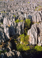
| Tsingy de Bemaraha Strict Nature Reserve Tsingy de Bemaraha Strict Nature Reserve Tsingy de Bemaraha Strict Nature Reserve is a nature reserve located near the western coast of Madagascar in Melaky Region at . The area was listed as a UNESCO World Heritage Site in 1990 due to the unique geography, preserved mangrove forests, and wild bird and lemur populations... |
 |
18°40′S 44°45′E | Melaky Melaky Melaky is a region in northwestern Madagascar. It borders Boeny Region in northeast, Betsiboka in east, Bongolava in southeast and Menabe in south. The capital of the region is Maintirano. The population was estimated to be 175,500 in 2004 within the area of... |
1990 | At the Tsingy de Bemaraha Strict Nature Reserve, gradual erosion has produced vast fields of karst KARST Kilometer-square Area Radio Synthesis Telescope is a Chinese telescope project to which FAST is a forerunner. KARST is a set of large spherical reflectors on karst landforms, which are bowlshaped limestone sinkholes named after the Kras region in Slovenia and Northern Italy. It will consist of... limestone spires known locally as tsingy. This singular landscape is interspersed with dry forests, lakes and mangrove swamps inhabited by numerous endemic and threatened lemur and bird species. |
||
| Royal Hill of Ambohimanga Ambohimanga The Royal Hill of Ambohimanga is a site of cultural and historical significance located approximately 24 kilometers to the east of the capital city of Antananarivo in Madagascar... |
18°45′S 47°33′E | Analamanga Analamanga Analamanga is a region in Madagascar, containing the capital Antananarivo and surrounding metropolitan area.Analamanga means "blue forest". It's also an older name for Antananarivo.*Capital: Antananarivo-Renivohitra.*Area: 17,445 km²*Population: 2,650,000... |
2001 | The Royal Hill of Ambohimanga in the central highlands has been a spiritual and political center for the Merina people since at least the 16th century. Home to numerous kings (including Andrianampoinimerina Andrianampoinimerina Ruling between 1787–1810, Andrianampoinimerina , born Ramboasalama or Ramboasalamarazaka at Ambohimanga around 1745 , initiated the unification of Madagascar under Merina rule and is considered one of the greatest military and political... , who undertook the ultimately successful initiative to unite the island of Madagascar under a single ruler) and designated site of many sacred royal rituals, the hill and the village that crowns it remain sites of pilgrimage to this day. |
|||
| Rainforests of the Atsinanana Rainforests of the Atsinanana The Rainforests of the Atsinanana is a World Heritage Site that was inscribed in 2007 and consists 13 specific areas located within six national parks in the eastern part of Madagascar... |
14°27′S 49°42′E | Sava, Analanjirofo Analanjirofo Analanjirofo is a region in northeastern Madagascar. Until 2009 it belonged to Toamasina Province. It borders Sava Region in north, Sofia in west, Alaotra-Mangoro in southwest and Atsinanana in south.Analanjirofo is divided into six districts:... , Haute Matsiatra Haute Matsiatra Haute Matsiatra is a region in Madagascar. It borders Amoron'i Mania region in north, Vatovavy-Fitovinany in east, Ihorombe in south and Atsimo-Andrefana in west. The capital of the region is Fianarantsoa, and the population was estimated to be 1,128,900 in 2004... , Vatovavy-Fitovinany Vatovavy-Fitovinany Vatovavy-Fitovinany is the South-East region of Madagascar.*Capital: Manakara*Chief: Philibert Andriatsimanirinarivo *Dialectical: Antemoro*Transportation mean:-Train -Car Taxi-Brousse -Plane... , Ihorombe Ihorombe Ihorombe is a region in Madagascar. It borders Haute Matsiatra region in north, Atsimo-Atsinanana in east, Anosy in south and Atsimo-Andrefana in west. The capital is Ihosy and the population was estimated to be 189,200 in 2004... , Anosy Anosy -Introduction:Anosy is a region in southeastern Madagascar. It borders Androy region in west, Atsimo-Andrefana in north-west, Ihorombe in north and Atsimo-Atsinanana in north-east. This region runs from approximately Manantenina in the northeast corner of the region, west to Ranomafana, west to... |
2007 | The six national parks that make up the Rainforests of the Atsinanana host a wide array of the distinctive flora and fauna endemic to Madagascar's rainforest ecosystems. The plant and animal life in these parks are threatened as the demands of a growing human population hasten deforestation and the fragmentation of remaining forests. This site was inscribed on the list of World Heritage in Danger in 2010 due to an increase in illegal logging in the parks following the 2009 coup d'etat. |
Tentative sites
Member states may choose to maintain a list of tentative sites that the World Heritage Committee may consider for nomination to the list of World Heritage Sites. Only sites previously listed on a country's tentative list may be nominated to the World Heritage List. Madagascar has recorded seven sites on its tentative list. The names and descriptions of all tentative sites are recorded by the UNESCO World Heritage Committee in the language selected by the nominating country. Tentative sites in Madagascar are named and described in French and have been unofficially translated below.| Name | Image | Location | Region Regions of Madagascar ||Madagascar is divided into 22 regions . These formerly second-tier administrative divisions became the first-level administrative divisions when the former six provinces were dissolved on 4 October 2009:- See also :* Subdivisions of Madagascar... |
Year | UNESCO data | Description | Reference |
|---|---|---|---|---|---|---|---|
| Paysage culturel rizicole et hydraulique de Betafo (Betafo Betafo Betafo refers to a town and surrounding district in Vakinankaratra Region, Madagascar, and a village in the district of Arivonimamo, in Itasy Region. The village's inhabitants are said to be divided between descendants of andriana and descendants of former slaves . This aspect was the subject... Riziculture and Hydraulic Landscape) |
19°50′S 46°51′E | Vakinankaratra Vakinankaratra Vakinankaratra is a region in Madagascar.*Capital: Antsirabe*Chief: Lantoniaina RabenantoandroThe region is divided into six districts and 86 communes:-Districts:*Antsirabe I*Antsirabe II*Ambatolampy District*Betafo District*Antanifotsy District... |
1997 | The landscape surrounding Betafo, capital of one of four ancient kingdoms of the Betsileo Betsileo The Betsileo are a highland ethnic group of Madagascar, the third largest in terms of population, numbering around 1.5 million and making up about 12.1 percent of the population. Their name means "The Many Invincible Ones" which they chose for themselves after the failed invasion of Ramitraho... people, exemplifies the traditional terraced rice paddies and irrigation systems that emerged in this part of the southern Highlands in the 17th century. |
|||
| Site et Rova de Tsinjoarivo (Royal Compound of Tsinjoarivo Tsinjoarivo, Ambatolampy Tsinjoarivo is a town and commune in Madagascar. It belongs to the district of Ambatolampy, which is a part of Vakinankaratra Region. The population of the commune was estimated to be approximately 20,000 in 2001 commune census.... ) |
19°38′S 47°41′E | Vakinankaratra Vakinankaratra Vakinankaratra is a region in Madagascar.*Capital: Antsirabe*Chief: Lantoniaina RabenantoandroThe region is divided into six districts and 86 communes:-Districts:*Antsirabe I*Antsirabe II*Ambatolampy District*Betafo District*Antanifotsy District... |
1997 | The Rova of Tsinjoarivo, a collection of five wooden and rammed earth summer palaces built by Merina Queen Ranavalona I Ranavalona I Ranavalona I , also known as Ranavalo-Manjaka I, was a sovereign of the Kingdom of Madagascar from 1828 to 1861... in 1834, offers a well-preserved example of traditional architectural norms among the Highland andriana Andriana Andriana is a title of nobility in Madagascar and often traditionally formed part of the names of noblemen, princes and kings. Historically, many Malagasy ethnic groups lived in highly stratified caste-based social orders in which the andriana were the political and/or spiritual leaders... (noble class). Several monarchs of the island lodged at the site, including Ranavalona I (1840, 1842, 1856), Ranavalona II (1880, 1882) and Ranavalona III (1890). |
|||
| Sud-Ouest Malgache, Pays Mahafaly (Mahafaly Mahafaly The Mahafaly are an ethnic group of Madagascar that inhabit the plains of the Betioky-Ampamihy area. Their name means either "those who make taboos" or "those who make happy", although the former is considered more likely by linguists... country of Southwestern Madagascar) |
23°21′S 43°40′E | Atsimo-Andrefana Atsimo-Andrefana Atsimo Andrefana is a region of Madagascar. It borders Menabe in north, Amoron'i Mania and Haute Matsiatra in northeast, Ihorombe and Anosy in east and Androy in southeast. The capital is Toliara and the population was estimated to be 1,018,500 in 2004... |
1997 | The south-west of Madagascar is inhabited by the Mahafaly people who farm and herd their zebu Zebu Zebu , sometimes known as humped cattle, indicus cattle, Cebu or Brahmin cattle are a type of domestic cattle originating in South Asia, particularly the Indian subcontinent. They are characterised by a fatty hump on their shoulders, drooping ears and a large dewlap... within the arid ecosystem of the spiny forests Madagascar spiny thickets The Madagascar spiny thickets is an ecoregion in Madagascar. The vegetation type is found on poor substrates with low, erratic winter rainfall. An estimated 14,000 to is covered with this habitat, all in the southwest of the country... , a semi-desert landscape of endemic succulents which include all plants of the family Didiereaceae Didiereaceae Didiereaceae is a small family of just four genera and 11 species of flowering plants endemic to south and southwest Madagascar, where they form an important component of the Madagascar spiny forests.-Description:... . The Mahafaly are famed for such funerary art as highly ornate stone tombs and carved wooden grave posts (aloalo Aloalo The aloalo is a funerary pole sculpture that, along with the skulls of slaughtered zebu, is placed on the tombs of important people in the south-western region of Madagascar. These carved posts often tell the story of the person's life and generally take the form of a series of geometric or... ), which have become emblematic of the island of Madagascar. |
|||
| Falaise et grottes de l'Isandra (Cliff and Caves of Isandra Isandra The Caves and Cliffs of Isandra are located in the Betsileo cultural region of Madagascar, roughly 30 km to the northwest of the regional capital of Fianarantsoa.- Site Description :... ) |
21°27′S 47°05′E | Haute Matsiatra Haute Matsiatra Haute Matsiatra is a region in Madagascar. It borders Amoron'i Mania region in north, Vatovavy-Fitovinany in east, Ihorombe in south and Atsimo-Andrefana in west. The capital of the region is Fianarantsoa, and the population was estimated to be 1,128,900 in 2004... |
1997 | The steep granite cliff of Isandra which rises abruptly from the surrounding rice fields is the product of differentiated erosion that has perforated the surface of the cliff with numerous caves. Some of these caverns were incorporated into a fortified village inhabited in the 17th and 18th centuries, while others were (and continue to be) utilized to entomb the dead. | |||
| Antongona Antongona The archaeological site of Antongona is located in the Imamo Region of Madagascar, roughly 36 km west of Antananarivo and 6 km north of Imerintsiatosika.- Site Description :... |
18°59′S 47°19′E | Itasy Itasy Itasy is a region in central Madagascar. It borders Analamanga region in northeast,Vakinankaratra in south and Bongolava in northwest. The capital of the region is Miarinarivo, and the population was estimated to be 643,000 in 2004... |
1997 | Beginning in the 16th century, two granite outcroppings at Antongona were fortified with defensive trenches, stone walls and gateways to protect the royal wooden lodgings at their peaks. In the 1980s, the Ministry of Culture reconstructed two of the site's original wooden buildings and opened them to the public as a museum. | |||
| Réserve Spéciale d’Anjanaharibe-Sud Anjanaharibe-Sud Reserve Anjanaharibe-Sud Reserve is a wildlife reserve of Madagascar. It was nominated to the UNESCO Tentative List of World Heritage Sites in Madagascar in 2008 as an extension to the Rainforests of the Atsinanana.... (Anjanaharibe-Sud Special Reserve: Extension of the Rainforests of the Atsinanana) |
14°41′S 49°27′E | Sava Sava Region Sava is a region of Madagascar. Its capital is Sambava. Until 2009 Sava belonged to Antsiranana Province. The region is situated at the northern part of the east coast of Madagascar. It is bordered by Diana to the north, Sofia to the west, and Analanjirofo to the south. The population was estimated... |
2008 | Anjanaharibe-Sud lies east of Marojejy National Park Marojejy National Park Marojejy National Park is a national park in the Sava Region of northeastern Madagascar. It covers and is centered around the Marojejy Massif, a mountain chain that rises to an elevation of . Access to the area around the massif was restricted to research scientists when the site was set aside as... , one of six parks constituting the Rainforests of the Atsinanana Rainforests of the Atsinanana The Rainforests of the Atsinanana is a World Heritage Site that was inscribed in 2007 and consists 13 specific areas located within six national parks in the eastern part of Madagascar... World Heritage Site World Heritage Site A UNESCO World Heritage Site is a place that is listed by the UNESCO as of special cultural or physical significance... . Numerous endemic plant species are found in Anjanaharibe-Sud, and the forest corridor of Betaolana connects the park to Marojejy, ensuring the wildlife of both parks access to greater territorial range. |
|||
| Les forêts sèches de l’Andrefana (Dry Forests of the Andrefana) |  |
12°53′S 49°09′E | Diana, Boeny, Anosy, Atsimo-Andrefana Atsimo-Andrefana Atsimo Andrefana is a region of Madagascar. It borders Menabe in north, Amoron'i Mania and Haute Matsiatra in northeast, Ihorombe and Anosy in east and Androy in southeast. The capital is Toliara and the population was estimated to be 1,018,500 in 2004... , Androy, Sava Sava Region Sava is a region of Madagascar. Its capital is Sambava. Until 2009 Sava belonged to Antsiranana Province. The region is situated at the northern part of the east coast of Madagascar. It is bordered by Diana to the north, Sofia to the west, and Analanjirofo to the south. The population was estimated... , Melaky |
2008 | The Dry Forests of the Andrefana comprise seven protected natural areas: Ankarana Reserve Ankarana Reserve Ankarana Reserve is a small, partially vegetated plateau in northern Madagascar composed of 150-million-year-old middle Jurassic limestone. With an average annual rainfall of about , the underlying rocks are susceptible to erosion, thereby producing caves and underground rivers—a karst topography... , Ankarafantsika National Park Ankarafantsika National Park Ankarafantsika National Park is a National Park in the Boeny Region of Madagascar. The closest city is Majunga 115 km north of the park. Ankarafantsika is mostly tropical in climate type. The Sakalava people are the predominate ethnic group in the park. The rodent Macrotarsomys ingens occurs only... , Andohahela National Park Andohahela National Park Andohahela National Park, in southeast Madagascar, is remarkable for the extremes of habitats that are representened within it. The park covers 760 square kilometers of the Anosy mountain range, the southernmost spur of the Malagasy Highlands... (parcel II), Tsimanampetsotse National Park Tsimanampetsotse National Park Tsimanampetsotse National Park also spelt Tsimanampetsotse, and known as Tsimanampetsotsa Nature Reserve is a national Park of Madagascar. It lies on the southwest coast, south of Toliara. It contains Lake Tsimanampetsotsa, an important wetland and a Ramsar site. The Ramsar site has a total area of... , Analamerana Reserve Analamerana Reserve Analamerana Reserve is a wildlife reserve of Madagascar.... , Manambolomaty-Tsimembo Madagascar dry deciduous forests The Madagascar dry deciduous forests represent a tropical dry forest ecoregion generally situated in the western part of Madagascar. The area has high numbers of endemic plant and animal species but has suffered large-scale clearance for agriculture... and a new reserve planned near Daraina Daraina Daraina is a town and commune in northern Madagascar. It belongs to the district of Vohemar, which is a part of Sava Region. The population of the commune was estimated to be approximately 10,000 in 2001 commune census.... . In contrast with the Rainforests of the Antsinanana, the parks included in the Dry Forests of the Andrefana are each located within semi-arid ecoregions and feature an entirely distinct set of highly biodiverse and endemic wildlife. |
External links
- Official photographs and descriptions of Madagascar's Tentative World Heritage List Sites