

List of Sites of Special Scientific Interest in Merseyside
Encyclopedia
Merseyside
Merseyside is a metropolitan county in North West England, with a population of 1,365,900. It encompasses the metropolitan area centred on both banks of the lower reaches of the Mersey Estuary, and comprises five metropolitan boroughs: Knowsley, St Helens, Sefton, Wirral, and the city of Liverpool...
, which is part of North West England
North West England
North West England, informally known as The North West, is one of the nine official regions of England.North West England had a 2006 estimated population of 6,853,201 the third most populated region after London and the South East...
. Merseyside has a population of 1,353,600 making it one of the most densely populated areas of the United Kingdom
United Kingdom
The United Kingdom of Great Britain and Northern IrelandIn the United Kingdom and Dependencies, other languages have been officially recognised as legitimate autochthonous languages under the European Charter for Regional or Minority Languages...
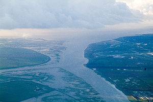
. Geographically, Merseyside is split by the River Mersey
River Mersey
The River Mersey is a river in North West England. It is around long, stretching from Stockport, Greater Manchester, and ending at Liverpool Bay, Merseyside. For centuries, it formed part of the ancient county divide between Lancashire and Cheshire....
which has a surrounding network of canals, rivers and valleys some of which have been created by human activity. Other habitats have been adversely affected by humans including many peat
Peat
Peat is an accumulation of partially decayed vegetation matter or histosol. Peat forms in wetland bogs, moors, muskegs, pocosins, mires, and peat swamp forests. Peat is harvested as an important source of fuel in certain parts of the world...
mosslands. , There are 14 sites designated within this Area of Search
Area of Search
Areas of Search are geographical areas used in the selection of Sites of Special Scientific Interest. In England these are largely based on the 1974–1996 administrative counties...
, of which 10 have been designated due to their biological interest, 1 due to its geological interest, and 3 for both biological and geological interest.
In England the body responsible for designating SSSIs is Natural England
Natural England
Natural England is the non-departmental public body of the UK government responsible for ensuring that England's natural environment, including its land, flora and fauna, freshwater and marine environments, geology and soils, are protected and improved...
, which chooses a site because of its fauna
Fauna
Fauna or faunæ is all of the animal life of any particular region or time. The corresponding term for plants is flora.Zoologists and paleontologists use fauna to refer to a typical collection of animals found in a specific time or place, e.g. the "Sonoran Desert fauna" or the "Burgess shale fauna"...
, flora
Plant
Plants are living organisms belonging to the kingdom Plantae. Precise definitions of the kingdom vary, but as the term is used here, plants include familiar organisms such as trees, flowers, herbs, bushes, grasses, vines, ferns, mosses, and green algae. The group is also called green plants or...
, geological
Geology
Geology is the science comprising the study of solid Earth, the rocks of which it is composed, and the processes by which it evolves. Geology gives insight into the history of the Earth, as it provides the primary evidence for plate tectonics, the evolutionary history of life, and past climates...
or physiographical features. Natural England took over the role of designating and managing SSSIs from English Nature
English Nature
English Nature was the United Kingdom government agency that promoted the conservation of wildlife, geology and wild places throughout England between 1990 and 2006...
in October 2006 when it was formed from the amalgamation of English Nature, parts of the Countryside Agency
Countryside Agency
The Countryside Agency in England was a statutory body set up in 1999 with the task of improving the quality of the rural environment and the lives of those living in it. The Agency was formed by merging the Countryside Commission and the Rural Development Commission...
and the Rural Development Service
Rural Development Service
The Rural Development Service was formerly part of the UK Government's Department for Environment, Food and Rural Affairs . It ceased to exist on 1 October 2006 following the creation of Natural England.- History :...
. Natural England, like its predecessor, uses the 1974–1996 county system
Metropolitan and non-metropolitan counties of England
Metropolitan and non-metropolitan counties are one of the four levels of subdivisions of England used for the purposes of local government outside Greater London. As originally constituted, the metropolitan and non-metropolitan counties each consisted of multiple districts, had a county council and...
and as such the same approach is followed here, rather than, for example, splitting these sites between the Lancashire and Cheshire lists. The data in the table is taken from English Nature's website in the form of citation sheets for each SSSI.
For other counties, see List of Sites of Special Scientific Interest by Area of Search.
Sites
| Site name | Reason for designation | Area | Grid reference | Year in which notified | Map | ||
|---|---|---|---|---|---|---|---|
| Biological interest | Geological interest | Hectares | Acres | ||||
| Dee Estuary Dee Estuary The Dee Estuary is a large estuary by means of which the River Dee flows into Liverpool Bay. The estuary starts near Shotton after a five miles 'canalised' section and the river soon swells to be several miles wide forming the boundary between the Wirral Peninsula in north-west England and... |
14.4 | 35.6 | 1979 | http://www.natureonthemap.naturalengland.org.uk/map.aspx?map=sssi&feature=1002872,sssi,HYPERLINK,LABEL | |||
| Dibbinsdale Dibbinsdale Brotherton Park and Dibbinsdale comprise an area of over of park and woodland within the Metropolitan Borough of Wirral, England.Situated between Spital and Bromborough, the valley woodland is one of the finest examples of ancient woodland on Merseyside and is a Site of Special Scientific Interest... |
53.2 | 131.5 | 1979 | http://www.natureonthemap.naturalengland.org.uk/map.aspx?map=sssi&feature=1002884,sssi,HYPERLINK,LABEL | |||
| Hesketh Golf Links Hesketh Golf Links Hesketh Golf Links is a 14.6 hectare Site of special scientific interest situated 2km north-east of Southport town centre. The site was notified in 1989 due to its biological features, in particular focusing on the presence of the nationally rare Sand lizard .-References:*... |
14.6 | 36.1 | 1989 | http://www.natureonthemap.naturalengland.org.uk/map.aspx?map=sssi&feature=1000353,sssi,HYPERLINK,LABEL | |||
| Heswall Dales Heswall Dales Heswall Dales is an area of some of lowland heath situated close to Heswall on the Wirral Peninsula, England.It is a Site of Special Scientific Interest and a Local Nature Reserve . Heswall Dales offers views of the Dee Estuary and over the River Dee the Clwydian Hills of Wales.-External links:* *... |
29.6 | 73.1 | 1979 | http://www.natureonthemap.naturalengland.org.uk/map.aspx?map=sssi&feature=1002996,sssi,HYPERLINK,LABEL | |||
| Meols Meadows Meols Meadows Meols Meadows is a 7.1 hectare Site of Special Scientific Interest on the Wirral Peninsula, England. It is situated near to the town of Moreton and 8 km north west of Birkenhead... |
7.1 | 17.5 | 1988 | http://www.natureonthemap.naturalengland.org.uk/map.aspx?map=sssi&feature=1002718,sssi,HYPERLINK,LABEL | |||
| Mersey Narrows | 117.8 | 291.1 | 2000 | http://www.natureonthemap.naturalengland.org.uk/map.aspx?map=sssi&feature=2000436,sssi,HYPERLINK,LABEL | |||
| New Ferry New Ferry New Ferry is a small town located on the Wirral Peninsula, England. Situated to the east of Bebington, it is part of the Bromborough Ward of the Metropolitan Borough of Wirral and in the parliamentary constituency of Wirral South... |
73.9 | 182.6 | 2000 | http://www.natureonthemap.naturalengland.org.uk/map.aspx?map=sssi&feature=2000435,sssi,HYPERLINK,LABEL | |||
| North Wirral Foreshore | 2109.9 | 5213.6 | 1979 | http://www.natureonthemap.naturalengland.org.uk/map.aspx?map=sssi&feature=1003676,sssi,HYPERLINK,LABEL | |||
| Red Rocks | 11.4 | 28.1 | 1979 | http://www.natureonthemap.naturalengland.org.uk/map.aspx?map=sssi&feature=1003697,sssi,HYPERLINK,LABEL | |||
| Ribble Estuary Ribble and Alt Estuaries The Ribble and Alt Estuaries lie on the Irish Sea coast of the counties of Lancashire and Merseyside in north-west England, and form the boundaries of a number of nature preservation schemes. -Protected area:... |
9226.3 | 22798.2 | 1966 | http://www.natureonthemap.naturalengland.org.uk/map.aspx?map=sssi&feature=1004299,sssi,HYPERLINK,LABEL | |||
| Sefton Coast Sefton Coast Sefton Coast is a 4605.3 hectare Site of special scientific interest which stretches for 12 miles between Southport and Waterloo, which is end location of Crosby Beach. The site was notified in 2000 for both its biological and geological features.-References:**... |
4605.3 | 11380.0 | 2000 | http://www.natureonthemap.naturalengland.org.uk/map.aspx?map=sssi&feature=2000426,sssi,HYPERLINK,LABEL | |||
| Stanley Bank Meadow Stanley Bank Meadow Stanley Bank Meadow is a 14.9 hectare Site of Special Scientific Interest situated 2.8km north-east of St Helens. The site was notified in 1988 due to its biological features which is predominately damp unimproved neutral grassland, which is a rare habitat in Merseyside.-References:*... |
14.9 | 36.8 | 1986 | http://www.natureonthemap.naturalengland.org.uk/map.aspx?map=sssi&feature=1002821,sssi,HYPERLINK,LABEL | |||
| The Dungeon The Dungeon SSSI The Dungeon is a 1.2 hectare Site of Special Scientific Interest situated 1 mile north-west of Heswall, on the Wirral Peninsula, England. The site was notified in 1988 due to its geological features which show the Tarporley Siltstone Formation of the Mercia Mudstone Group.-References:*-External... |
1.2 | 2.8 | 1977 | http://www.natureonthemap.naturalengland.org.uk/map.aspx?map=sssi&feature=1002901,sssi,HYPERLINK,LABEL | |||
| Thurstaston Common Thurstaston Common Royden Park and Thurstaston Common comprise an area of almost 250 acres of parklands, wood and heath at Thurstaston, within the Metropolitan Borough of Wirral, England.... |
70.8 | 174.9 | 1954 | http://www.natureonthemap.naturalengland.org.uk/map.aspx?map=sssi&feature=1003730,sssi,HYPERLINK,LABEL |