

List of Registered Historic Places in the Northern Mariana Islands
Encyclopedia
National Register of Historic Places
The National Register of Historic Places is the United States government's official list of districts, sites, buildings, structures, and objects deemed worthy of preservation...
in the Northern Mariana Islands
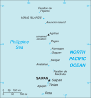
Northern Mariana Islands
The Northern Mariana Islands, officially the Commonwealth of the Northern Mariana Islands , is a commonwealth in political union with the United States, occupying a strategic region of the western Pacific Ocean. It consists of 15 islands about three-quarters of the way from Hawaii to the Philippines...
. There currently 36 listed sites spread across the four municipalites of the Northern Mariana Islands. There are no sites listed on any of the islands that make up the Northern Islands Municipality
Northern Islands Municipality
Northern Islands Municipality is one of the four main political divisions of the Commonwealth of the Northern Mariana Islands. It consists of a long string of the northernmost islands of the Northern Marianas, including Farallon de Pajaros, the Maug Islands, Asuncion, Agrihan, Pagan, Alamagan,...
.
Numbers of listings
The following are approximate tallies of current listings in American Samoa on the National Register of Historic Places. These counts are based on entries in the National Register Information Database as of April 24, 2008 and new weekly listings posted since then on the National Register of Historic Places web site. There are frequent additions to the listings and occasional delistings and the counts here are not official. Also, the counts in this table exclude boundary increase and decrease listings which modify the area covered by an existing property or district and which carry a separate National Register reference number.| Municipality | # of Sites | |
|---|---|---|
| 1 | Northern Islands | 0 |
| 2 | Rota | 9 |
| 3 | Saipan | 20 |
| 4 | Tinian | 7 |
| Total: | 36 | |
Rota
| Landmark name | Image | Date listed | Location | Village | Summary | |
|---|---|---|---|---|---|---|
| 1 | Chugai' Pictograph Site | Address Restricted | Chugai' | |||
| 2 | Commissioner's Office | North of Songsong Village 14°10′2"N 145°9′46"E |
Songsong Songsong Songsong is the largest village on the island of Rota, Northern Mariana Islands, United States. As of 2000, its population is 1,321. Songsong is located along the southern coast, in a narrow peninsula. The village's most recognizable landmark is Mt. Taipingot, more commonly known as Wedding... |
|||
| 3 | Dugi Archeological Site | Address Restricted | Songsong Songsong Songsong is the largest village on the island of Rota, Northern Mariana Islands, United States. As of 2000, its population is 1,321. Songsong is located along the southern coast, in a narrow peninsula. The village's most recognizable landmark is Mt. Taipingot, more commonly known as Wedding... |
|||
| 4 | Japanese Coastal Defense Gun | Northeast of Songsong 14°7′13"N 145°9′59"E |
Songsong Songsong Songsong is the largest village on the island of Rota, Northern Mariana Islands, United States. As of 2000, its population is 1,321. Songsong is located along the southern coast, in a narrow peninsula. The village's most recognizable landmark is Mt. Taipingot, more commonly known as Wedding... |
|||
| 5 | Japanese Hospital | West side of Sasanhaya Bay 14°8′13"N 145°8′18"E |
Songsong Songsong Songsong is the largest village on the island of Rota, Northern Mariana Islands, United States. As of 2000, its population is 1,321. Songsong is located along the southern coast, in a narrow peninsula. The village's most recognizable landmark is Mt. Taipingot, more commonly known as Wedding... |
|||
| 6 | Mochong | Address Restricted | Songsong Songsong Songsong is the largest village on the island of Rota, Northern Mariana Islands, United States. As of 2000, its population is 1,321. Songsong is located along the southern coast, in a narrow peninsula. The village's most recognizable landmark is Mt. Taipingot, more commonly known as Wedding... |
|||
| 7 | Nanyo Kohatsu Kabushiki Kaisha Sugar Mill | Southwest of Songsong Village, near the harbor 14°8′9"N 145°8′15"E |
Songsong Songsong Songsong is the largest village on the island of Rota, Northern Mariana Islands, United States. As of 2000, its population is 1,321. Songsong is located along the southern coast, in a narrow peninsula. The village's most recognizable landmark is Mt. Taipingot, more commonly known as Wedding... |
|||
| 8 | Rectory | North end of the island 14°9′59"N 145°10′0"E |
Songsong Songsong Songsong is the largest village on the island of Rota, Northern Mariana Islands, United States. As of 2000, its population is 1,321. Songsong is located along the southern coast, in a narrow peninsula. The village's most recognizable landmark is Mt. Taipingot, more commonly known as Wedding... |
|||
| 9 | Rota Latte Stone Quarry | Address Restricted | Songsong Songsong Songsong is the largest village on the island of Rota, Northern Mariana Islands, United States. As of 2000, its population is 1,321. Songsong is located along the southern coast, in a narrow peninsula. The village's most recognizable landmark is Mt. Taipingot, more commonly known as Wedding... |
Saipan
| Landmark name | Image | Date listed | Location | Village | Summary | |
|---|---|---|---|---|---|---|
| 1 | Landing Beaches, Aslito–Isley Field and Marpi Point Landing Beaches; Aslito/Isley Field; & Marpi Point, Saipan Island The Landing Beaches; Aslito/Isley Field & Marpi Point, Saipan Island are several historic locations on the island of Saipan which are collectively listed as a National Historic Landmark. These were the locations of pivotal sites during the Battle of Saipan when the United States Marines attacked... |
Saipan International Airport Saipan International Airport - See also :* East Field * USAAF in the Central Pacific-References:* Dorr, Robert F. B-29 Units of World War II. Botley, Oxford, UK: Osprey Publishing, 2002. ISBN 1-84176-285-7... and Beaches 15°6′55"N 145°43′1"E |
Chalan Kanoa Chalan Kanoa Chalan Kanoa is a settlement in Saipan, in the Northern Mariana Islands. It is located in the southwest of the island. The village contains the island's central post office, as well as the historic Mt Carmel Catholic Church. Mount Carmel School, Home of the Knights, one of the best schools on... |
|||
| 2 | Isley Field Historic District | Saipan International Airport Saipan International Airport - See also :* East Field * USAAF in the Central Pacific-References:* Dorr, Robert F. B-29 Units of World War II. Botley, Oxford, UK: Osprey Publishing, 2002. ISBN 1-84176-285-7... 15°7′20"N 145°43′58"E |
Chalan Kanoa Chalan Kanoa Chalan Kanoa is a settlement in Saipan, in the Northern Mariana Islands. It is located in the southwest of the island. The village contains the island's central post office, as well as the historic Mt Carmel Catholic Church. Mount Carmel School, Home of the Knights, one of the best schools on... |
|||
| 3 | Unai Obyan Latte Site | Address Restricted | Chalan Kanoa Chalan Kanoa Chalan Kanoa is a settlement in Saipan, in the Northern Mariana Islands. It is located in the southwest of the island. The village contains the island's central post office, as well as the historic Mt Carmel Catholic Church. Mount Carmel School, Home of the Knights, one of the best schools on... |
|||
| 4 | Waherak MAIHER | Public Works Headquarters Compound | Chalan Kanoa Chalan Kanoa Chalan Kanoa is a settlement in Saipan, in the Northern Mariana Islands. It is located in the southwest of the island. The village contains the island's central post office, as well as the historic Mt Carmel Catholic Church. Mount Carmel School, Home of the Knights, one of the best schools on... |
|||
| 5 | Campaneyan Kristo Rai | Beach Road 15°12′11"N 145°43′4"E |
Garapan Garapan Garapan is the largest village and the center of the tourism industry on the island of Saipan, which is a part of the United States Commonwealth of the Northern Mariana Islands .... |
|||
| 6 | Chalan Galaide | Address Restricted | Garapan Garapan Garapan is the largest village and the center of the tourism industry on the island of Saipan, which is a part of the United States Commonwealth of the Northern Mariana Islands .... |
|||
| 7 | Japanese Hospital | Route 3 15°12′6"N 145°43′8"E |
Garapan Garapan Garapan is the largest village and the center of the tourism industry on the island of Saipan, which is a part of the United States Commonwealth of the Northern Mariana Islands .... |
|||
| 8 | Japanese Jail Historic and Archeological District | Chichirica Avenue and Ghiyobw Street 15°21′1"N 145°43′7.5"E |
Garapan Garapan Garapan is the largest village and the center of the tourism industry on the island of Saipan, which is a part of the United States Commonwealth of the Northern Mariana Islands .... |
|||
| 9 | Japanese Lighthouse | Navy Hill15°12′48"N 145°43′59"E | Garapan Garapan Garapan is the largest village and the center of the tourism industry on the island of Saipan, which is a part of the United States Commonwealth of the Northern Mariana Islands .... |
|||
| 10 | Managaha Island Historic District | West of Saipan 15°14′29"N 145°42′45"E |
Garapan Garapan Garapan is the largest village and the center of the tourism industry on the island of Saipan, which is a part of the United States Commonwealth of the Northern Mariana Islands .... |
|||
| 11 | Sabanetan Toro Latte Site | Address Restricted | Garapan Garapan Garapan is the largest village and the center of the tourism industry on the island of Saipan, which is a part of the United States Commonwealth of the Northern Mariana Islands .... |
|||
| 12 | Laulau Kattan Latte Site | Address Restricted | Kagman III Homestead | |||
| 13 | Hachiman Jinja | Lot numbers H 300–11 and H 300–4 15°10′44"N 145°45′40"E |
Kannat Taddong Papago | |||
| 14 | Unai Achugao Archaeological Site | Address Restricted | Punton Achugao | |||
| 15 | Japanese 20mm Cannon Blockhouse | Northwest of Punton Opyan 15°6′46"N 145°42′17"E |
Saipan Island Saipan Saipan is the largest island of the United States Commonwealth of the Northern Mariana Islands , a chain of 15 tropical islands belonging to the Marianas archipelago in the western Pacific Ocean with a total area of . The 2000 census population was 62,392... |
|||
| 16 | Tachognya | Address Restricted | San Jose | |||
| 17 | Banzai Cliff | Bandero, Magpi area 15°17′17"N 145°48′58"E |
San Roque | |||
| 18 | Suicide Cliff | Bandero 15°16′38"N 145°48′35"E |
San Roque | |||
| 19 | Unai Lagua Japanese Defense Pillbox | Unai Lagua 15°16′25"N 145°49′42"E |
San Roque | |||
| 20 | Brown Beach One Japanese Fortifications | Unai Laolao Kattan (North Laolao Beach) along the east coast of Saipan 15°10′33"N 145°47′5"E |
Unai Laolao Kattan |
Tinian
| Landmark name | Image | Date listed | Location | Village | Summary | |
|---|---|---|---|---|---|---|
| 1 | House of Taga | San Jose Village 14°58′0.5"N 145°37′20"E |
San Jose Village San Jose, Northern Mariana Islands San Jose is the largest village on the island of Tinian, in the Northern Mariana Islands. It is located on the south coast of the island, close to the island's main harbor and three popular beaches: Kammer Beach, Taga Beach, and Tachogna Beach.... |
|||
| 2 | Japanese Structure | Near Red 2 Beach 14°58′16"N 145°37′14"E |
Tinian Village | |||
| 3 | Nanyo Kohatsu Kabushiki Kaisha Administration Building | Near Red 2 Beach 14°58′20"N 145°37′8"E |
Tinian Village | |||
| 4 | Nanyo Kohatsu Kabushiki Kaisha Ice Storage Building | Near Red 2 Beach 14°58′4"N 145°37′23"E |
Tinian Village | |||
| 5 | Nanyo Kohatsu Kabushiki Kaisha Laboratory | Near Red 2 Beach 14°58′20"N 145°37′7"E |
Tinian Village | |||
| 6 | Tinian Landing Beaches, Ushi Point Field, Tinian Island | 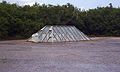 |
15°4′10"N 145°37′0"E | Tinian Village | ||
| 7 | Unai Dangkulo Petroglyph Site | Address Restricted | Unai Dangkulo |
See also
- List of United States National Historic Landmarks in United States commonwealths and territories, associated states, and foreign states