

List of Pillars of Montana
Encyclopedia
There are least 73 named Pillars in Montana according to the U.S. Geological Survey, U.S. Board of Geological Names. A Pillar is defined as: "Vertical, standing, often spire-shaped, natural rock formation (chimney, monument, pinnacle, pohaku, rock tower)." The Oxford Dictionary of Geography defines Earth Pillar as: "An upstanding, free column of soil that has been sheltered from erosion by a natural cap of stone on the top. They are common where boulder-rich moraines have been subject to gully erosion, as in parts of the southern Tyrol.
- Alcatraz Rock, Fallon County, MontanaFallon County, MontanaFallon County is a county located in the U.S. state of Montana. As of 2010, the population was 2,890. Its county seat is Baker.Fallon County was created in 1913 after being carved out of Custer County. The name comes from Benjamin O'Fallon, a nephew of Captain William Clark and an Indian agent...
, 46°03′18"N 104°28′12"W, el. 3396 feet (1,035.1 m) - Alp Rock, Park County, MontanaPark County, MontanaPark Counties in Montana and Wyoming are among the very few pairs of counties in the United States with the same name to border each other across state lines.-National protected areas:* Custer National Forest * Gallatin National Forest...
, 45°05′14"N 109°54′04"W, el. 9793 feet (2,984.9 m) - Baker Monument, Fergus County, MontanaFergus County, Montana-National protected areas:* Charles M. Russell National Wildlife Refuge * Lewis and Clark National Forest * Upper Missouri River Breaks National Monument -Demographics:...
, 47°40′59"N 108°58′27"W, el. 3081 feet (939.1 m) - Barking Dog, Lewis and Clark County, MontanaLewis and Clark County, Montana-National protected areas:* Flathead National Forest * Helena National Forest * Lewis and Clark National Forest * Lolo National Forest * Rocky Mountain Front Conservation Area -Demographics:...
, 46°48′27"N 111°38′02"W, el. 5426 feet (1,653.8 m) - Bear Tooth, Liberty County, MontanaLiberty County, Montana-Demographics:As of the census of 2000, there were 2,158 people, 833 households, and 583 families residing in the county. The population density was 2 people per square mile . There were 1,070 housing units at an average density of 1 per square mile...
, 48°49′34"N 111°07′07"W, el. 4790 feet (1,460 m) - Big Rock, Glacier County, MontanaGlacier County, Montana-National protected areas:* Glacier National Park * Lewis and Clark National Forest -Demographics:As of the census of 2000, there were 13,247 people, 4,304 households, and 3,245 families residing in the county. The population density was 4 people per square mile . There were 5,243 housing units...
, 48°26′32"N 113°04′05"W, el. 4793 feet (1,460.9 m) - Black Rock, Chouteau County, MontanaChouteau County, Montana-National protected areas:* Lewis and Clark National Forest * Upper Missouri River Breaks National Monument -Economy:Chouteau County is the largest winter wheat producer for the state of Montana...
, 47°39′30"N 110°22′37"W, el. 3340 feet (1,018 m) - Castle Rock, Powell County, MontanaPowell County, Montana-National protected areas:* Beaverhead-Deerlodge National Forest * Flathead National Forest * Grant-Kohrs Ranch National Historic Site* Helena National Forest * Lolo National Forest * Bob Marshall Wilderness Area...
, 46°32′11"N 112°39′49"W, el. 5686 feet (1,733.1 m) - Castle Rock, Pondera County, MontanaPondera County, Montana-National protected area:*Lewis and Clark National Forest *Rocky Mountain Front Conservation Area -Demographics:As of the census of 2000, there were 6,424 people, 2,410 households, and 1,740 families residing in the county. The population density was 4 people per square mile . There were 2,834...
, 48°10′11"N 112°13′33"W, el. 4035 feet (1,229.9 m) - Castle Rock, Park County, MontanaPark County, MontanaPark Counties in Montana and Wyoming are among the very few pairs of counties in the United States with the same name to border each other across state lines.-National protected areas:* Custer National Forest * Gallatin National Forest...
, 45°19′20"N 110°33′43"W, el. 6709 feet (2,044.9 m) - Castle Rock, Carter County, MontanaCarter County, Montana-Demographics:As of the census of 2000, there were 1,360 people, 543 households, and 382 families residing in the county. The population density was -Demographics:...
, 46°02′27"N 104°27′47"W, el. 3445 feet (1,050 m) - Castle Rock Spire, Carbon County, MontanaCarbon County, Montana-National protected areas:* Bighorn Canyon National Recreation Area * Custer National Forest * Gallatin National Forest -Economy:During the early history of Carbon County, coal mining was the predominant industry...
, 45°05′50"N 109°38′35"W, el. 12539 feet (3,821.9 m) - Castle Rocks, Phillips County, MontanaPhillips County, Montana-National protected areas:* Bowdoin National Wildlife Refuge* Charles M. Russell National Wildlife Refuge * Hewitt Lake National Wildlife Refuge* UL Bend National Wildlife Refuge* Upper Missouri River Breaks National Monument -Demographics:...
, 47°49′39"N 107°27′00"W, el. 3054 feet (930.9 m) - Castle Rocks, Big Horn County, MontanaBig Horn County, Montana- National protected areas :* Bighorn Canyon National Recreation Area * Little Bighorn Battlefield National Monument- Economy :Coal Mining and Agriculture both play major roles in Big Horn County’s economy...
, 45°20′05"N 108°32′42"W, el. 5810 feet (1,770.9 m) - Chimney Rock, Carter County, MontanaCarter County, Montana-Demographics:As of the census of 2000, there were 1,360 people, 543 households, and 382 families residing in the county. The population density was -Demographics:...
, 45°30′34"N 104°17′14"W, el. 3802 feet (1,158.8 m) - Chimney Rock, Dawson County, MontanaDawson County, Montana-Economy:Dawson County is known for its dryland grain, coal mines and gas and oil wells. There are 522 current farms and ranches, and 296 commercial businesses.-Demographics:...
, 47°30′39"N 104°32′48"W, el. 2303 feet (702 m) - Chimney Rock, Park County, MontanaPark County, MontanaPark Counties in Montana and Wyoming are among the very few pairs of counties in the United States with the same name to border each other across state lines.-National protected areas:* Custer National Forest * Gallatin National Forest...
, 45°03′21"N 109°57′11"W, el. 10216 feet (3,113.8 m) - Chimney Rock, Powder River County, MontanaPowder River County, Montana-Demographics:As of the census of 2000, there were 1,858 people, 737 households, and 524 families residing in the county. The population density was -Demographics:...
, 45°26′36"N 106°01′54"W, el. 3770 feet (1,149.1 m) - Chimney Rock, Park County, MontanaPark County, MontanaPark Counties in Montana and Wyoming are among the very few pairs of counties in the United States with the same name to border each other across state lines.-National protected areas:* Custer National Forest * Gallatin National Forest...
, 45°31′58"N 110°46′36"W, el. 7480 feet (2,279.9 m) - Citadel Rock, Chouteau County, MontanaChouteau County, Montana-National protected areas:* Lewis and Clark National Forest * Upper Missouri River Breaks National Monument -Economy:Chouteau County is the largest winter wheat producer for the state of Montana...
, 47°49′55"N 110°04′26"W, el. 2566 feet (782.1 m) - Cleft Rock, Flathead County, MontanaFlathead County, Montana-National protected areas:* Pacific Northwest National Scenic Trail * Flathead National Forest * Glacier National Park * Kootenai National Forest * Lolo National Forest * Lost Trail National Wildlife Refuge-Demographics:...
, 48°55′02"N 114°31′37"W, el. 7142 feet (2,176.9 m) - Crow Rock, Garfield County, MontanaGarfield County, Montana-Politics:Garfield County is a solidly Republican county. It might be the most Republican county in Montana and one of the most Republican in the nation....
, 46°57′21"N 106°07′07"W, el. 2700 feet (823 m) - Cupids Heart, Gallatin County, MontanaGallatin County, Montana-National protected areas:* Gallatin National Forest * Yellowstone National Park -Demographics:As of the census of 2000, there were 67,831 people, 26,323 households, and 16,188 families residing in the county. The population density was 26 people per square mile . There were 29,489 housing units...
, 45°24′38"N 110°56′57"W, el. 8809 feet (2,685 m) - Dog Tooth Rock, Park County, MontanaPark County, MontanaPark Counties in Montana and Wyoming are among the very few pairs of counties in the United States with the same name to border each other across state lines.-National protected areas:* Custer National Forest * Gallatin National Forest...
, 45°12′44"N 110°58′29"W, el. 7739 feet (2,358.8 m) - Dutch Oven, Garfield County, MontanaGarfield County, Montana-Politics:Garfield County is a solidly Republican county. It might be the most Republican county in Montana and one of the most Republican in the nation....
, 46°54′41"N 107°46′54"W, el. 3123 feet (951.9 m) - Eagle Nest Rock, Park County, MontanaPark County, MontanaPark Counties in Montana and Wyoming are among the very few pairs of counties in the United States with the same name to border each other across state lines.-National protected areas:* Custer National Forest * Gallatin National Forest...
, 45°00′40"N 110°41′37"W, el. 5499 feet (1,676.1 m)
- Eagle Rock, McCone County, MontanaMcCone County, Montana-Demographics:As of the census of 2000, there were 1,977 people, 810 households, and 596 families residing in the county. The population density was 1 people per square mile . There were 1,087 housing units at an average density of 0 per square mile...
, 47°32′20"N 106°05′23"W, el. 2654 feet (808.9 m) - Eagle Rock, Chouteau County, MontanaChouteau County, Montana-National protected areas:* Lewis and Clark National Forest * Upper Missouri River Breaks National Monument -Economy:Chouteau County is the largest winter wheat producer for the state of Montana...
, 47°51′41"N 110°03′47"W, el. 2572 feet (783.9 m) - Eagle Rock, Beaverhead County, MontanaBeaverhead County, Montana-National protected areas:* Beaverhead National Forest * Big Hole National Battlefield* Nez Perce National Historical Park * Red Rock Lakes National Wildlife Refuge-History:...
, 45°42′24"N 113°01′53"W, el. 6568 feet (2,001.9 m) - Eglise Rock, Madison County, MontanaMadison County, Montana-National protected areas:*Beaverhead National Forest *Deerlodge National Forest *Gallatin National Forest -Demographics:As of the census of 2000, there were 6,851 people, 2,956 households, and 1,921 families residing in the county. The population density was 2 people per square mile...
, 45°12′22"N 111°25′36"W, el. 9485 feet (2,891 m) - Elephant Rock, Meagher County, MontanaMeagher County, Montana-National protected areas:*Gallatin National Forest *Helena National Forest *Lewis and Clark National Forest -Demographics:As of the census of 2000, there were 1,932 people, 803 households, and 529 families residing in the county...
, 46°37′51"N 110°29′26"W, el. 6447 feet (1,965 m) - Goat Rocks, Sanders County, MontanaSanders County, MontanaSanders County is a county located in the U.S. state of Montana. As of 2010, the population was 11,413. Its county seat is Thompson Falls.-Geography:According to the U.S...
, 48°08′04"N 115°43′33"W, el. 4242 feet (1,293 m) - Goose Rock, Missoula County, MontanaMissoula County, Montana-National protected areas:*Bitterroot National Forest *Flathead National Forest *Lolo National Forest *Rattlesnake National Recreation Area-Demographics:...
, 46°56′52"N 113°34′37"W, el. 3527 feet (1,075 m) - Haystack Butte, Chouteau County, MontanaChouteau County, Montana-National protected areas:* Lewis and Clark National Forest * Upper Missouri River Breaks National Monument -Economy:Chouteau County is the largest winter wheat producer for the state of Montana...
, 48°00′01"N 111°10′08"W, el. 3560 feet (1,085.1 m) - History Rock, Gallatin County, MontanaGallatin County, Montana-National protected areas:* Gallatin National Forest * Yellowstone National Park -Demographics:As of the census of 2000, there were 67,831 people, 26,323 households, and 16,188 families residing in the county. The population density was 26 people per square mile . There were 29,489 housing units...
, 45°29′30"N 110°59′44"W, el. 6798 feet (2,072 m) - Indian Head Rock, Jefferson County, MontanaJefferson County, Montana-National protected areas:*Deerlodge National Forest *Helena National Forest -Demographics:As of the census of 2000, there were 10,049 people, 3,747 households, and 2,847 families residing in the county. The population density was 6 people per square mile . There were 4,199 housing units at an...
, 46°16′08"N 112°18′34"W, el. 5676 feet (1,730 m) - Indian Head Rock, Cascade County, MontanaCascade County, Montana-National protected areas:*Benton Lake National Wildlife Refuge*Lewis and Clark National Forest -Economy:Malmstrom Air Force Base is a driving force in the regional economy...
, coordinates unknown, el. 3425 feet (1,043.9 m) - Indian Rock, Fergus County, MontanaFergus County, Montana-National protected areas:* Charles M. Russell National Wildlife Refuge * Lewis and Clark National Forest * Upper Missouri River Breaks National Monument -Demographics:...
, 47°04′29"N 109°36′18"W, el. 4058 feet (1,236.9 m) - Jones Cone, Fergus County, MontanaFergus County, Montana-National protected areas:* Charles M. Russell National Wildlife Refuge * Lewis and Clark National Forest * Upper Missouri River Breaks National Monument -Demographics:...
, 47°40′10"N 109°27′05"W, el. 2762 feet (841.9 m) - LaBarge RockLaBarge RockLaBarge Rock in Choteau County, Montana is a dramatic landform in the shape of a large rock column or pillar, rising 150 feet from waters' edge of the Missouri River. Besides having a striking appearance, LaBarge Rock is located in a picturesque riverside setting which has attracted artists and...
, Chouteau County, MontanaChouteau County, Montana-National protected areas:* Lewis and Clark National Forest * Upper Missouri River Breaks National Monument -Economy:Chouteau County is the largest winter wheat producer for the state of Montana...
, 47°54′40"N 110°03′42"W, el. 2648 feet (807.1 m) - Mil-mil-teh Hill, Meagher County, MontanaMeagher County, Montana-National protected areas:*Gallatin National Forest *Helena National Forest *Lewis and Clark National Forest -Demographics:As of the census of 2000, there were 1,932 people, 803 households, and 529 families residing in the county...
, 46°53′57"N 111°31′44"W, el. 6821 feet (2,079 m) - Napi Rock, Glacier County, MontanaGlacier County, Montana-National protected areas:* Glacier National Park * Lewis and Clark National Forest -Demographics:As of the census of 2000, there were 13,247 people, 4,304 households, and 3,245 families residing in the county. The population density was 4 people per square mile . There were 5,243 housing units...
, 48°44′51"N 113°29′25"W, el. 7474 feet (2,278.1 m) - Needle Butte, Rosebud County, MontanaRosebud County, Montana-Demographics:As of the census of 2000, there were 9,383 people, 3,307 households, and 2,417 families residing in the county. The population density was 2 people per square mile . There were 3,912 housing units at an average density of 1 per square mile...
, 46°47′23"N 106°37′20"W, el. 3251 feet (990.9 m) - Peyton Rock, Ravalli County, MontanaRavalli County, Montana-National protected areas:*Bitterroot National Forest *Lee Metcalf National Wildlife Refuge*Lolo National Forest -Demographics:As of the census of 2000 , there were 36,070 people, 14,289 households, and 10,188 families residing in the county. The population density was 15 people per square mile...
, 45°44′56"N 114°25′59"W, el. 5650 feet (1,722.1 m) - Pikes Peak, Valley County, MontanaValley County, Montana-Demographics:As of the census of 2000, there were 7,675 people, 3,150 households, and 2,129 families residing in the county. The population density was 2 people per square mile . There were 4,847 housing units at an average density of 1 per square mile...
, 48°47′36"N 106°35′58"W, el. 3097 feet (944 m) - Pilot Rock, Chouteau County, MontanaChouteau County, Montana-National protected areas:* Lewis and Clark National Forest * Upper Missouri River Breaks National Monument -Economy:Chouteau County is the largest winter wheat producer for the state of Montana...
, 47°58′27"N 110°06′10"W, el. 2526 feet (769.9 m) - Pipe Organ Rock, Beaverhead County, MontanaBeaverhead County, Montana-National protected areas:* Beaverhead National Forest * Big Hole National Battlefield* Nez Perce National Historical Park * Red Rock Lakes National Wildlife Refuge-History:...
, 45°04′02"N 112°48′14"W, el. 5479 feet (1,670 m) - Point Stupid, Park County, MontanaPark County, MontanaPark Counties in Montana and Wyoming are among the very few pairs of counties in the United States with the same name to border each other across state lines.-National protected areas:* Custer National Forest * Gallatin National Forest...
, 45°24′42"N 110°48′51"W, el. 7802 feet (2,378 m) - Point of Rocks, Flathead County, MontanaFlathead County, Montana-National protected areas:* Pacific Northwest National Scenic Trail * Flathead National Forest * Glacier National Park * Kootenai National Forest * Lolo National Forest * Lost Trail National Wildlife Refuge-Demographics:...
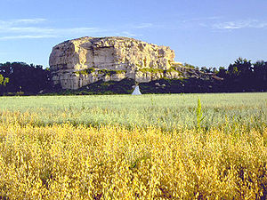
, 48°38′40"N 114°43′22"W, el. 3412 feet (1,040 m) - Pompeys PillarPompey's Pillar, MontanaPompey's Pillar is an unincorporated community in Yellowstone County, Montana, United States.-History:Founded in 1907, Pompey's Pillar was built and named after the site of a famous natural landmark where William Clark inscribed his name on July 25, 1806 during his trip down the Yellowstone River...
, Yellowstone County, MontanaYellowstone County, Montana-National protected areas:* Nez Perce National Historical Park * Pompeys Pillar National Monument-Demographics:As of the census of 2000, there were 129,352 people, 52,084 households, and 34,219 families residing in the county. The population density was 49 people per square mile . There were...
, 45°59′43"N 108°00′19"W, el. 3005 feet (915.9 m) - Prohibition Rock, Gallatin County, MontanaGallatin County, Montana-National protected areas:* Gallatin National Forest * Yellowstone National Park -Demographics:As of the census of 2000, there were 67,831 people, 26,323 households, and 16,188 families residing in the county. The population density was 26 people per square mile . There were 29,489 housing units...
, 45°07′32"N 111°13′03"W, el. 7887 feet (2,404 m) - Proposal Rock, Beaverhead County, MontanaBeaverhead County, Montana-National protected areas:* Beaverhead National Forest * Big Hole National Battlefield* Nez Perce National Historical Park * Red Rock Lakes National Wildlife Refuge-History:...
, 45°38′06"N 113°21′19"W, el. 7598 feet (2,315.9 m) - Pulpit Rock, Gallatin County, MontanaGallatin County, Montana-National protected areas:* Gallatin National Forest * Yellowstone National Park -Demographics:As of the census of 2000, there were 67,831 people, 26,323 households, and 16,188 families residing in the county. The population density was 26 people per square mile . There were 29,489 housing units...
, 45°05′00"N 111°12′43"W, el. 6880 feet (2,097 m) - Pumpelly Pillar, Glacier County, MontanaGlacier County, Montana-National protected areas:* Glacier National Park * Lewis and Clark National Forest -Demographics:As of the census of 2000, there were 13,247 people, 4,304 households, and 3,245 families residing in the county. The population density was 4 people per square mile . There were 5,243 housing units...
, 48°28′29"N 113°27′02"W, el. 7457 feet (2,272.9 m) - Red Rock, Missoula County, MontanaMissoula County, Montana-National protected areas:*Bitterroot National Forest *Flathead National Forest *Lolo National Forest *Rattlesnake National Recreation Area-Demographics:...
, 46°56′28"N 113°35′24"W, el. 3566 feet (1,086.9 m) - Road Agents Rock, Beaverhead County, MontanaBeaverhead County, Montana-National protected areas:* Beaverhead National Forest * Big Hole National Battlefield* Nez Perce National Historical Park * Red Rock Lakes National Wildlife Refuge-History:...
, 45°11′48"N 112°58′12"W, el. 6667 feet (2,032.1 m) - Sand Rocks, Blaine County, MontanaBlaine County, Montana-National protected areas:* Black Coulee National Wildlife Refuge* Nez Perce National Historical Park * Upper Missouri River Breaks National Monument -Economy:The main industry in Blaine County is Agriculture...
, 48°17′56"N 109°09′47"W, el. 3707 feet (1,129.9 m) - Sentinel Rock, Lewis and Clark County, MontanaLewis and Clark County, Montana-National protected areas:* Flathead National Forest * Helena National Forest * Lewis and Clark National Forest * Lolo National Forest * Rocky Mountain Front Conservation Area -Demographics:...
, 47°00′21"N 112°03′35"W, el. 3563 feet (1,086 m) - Sheep Rock, Gallatin County, MontanaGallatin County, Montana-National protected areas:* Gallatin National Forest * Yellowstone National Park -Demographics:As of the census of 2000, there were 67,831 people, 26,323 households, and 16,188 families residing in the county. The population density was 26 people per square mile . There were 29,489 housing units...
, 45°28′42"N 111°15′58"W, el. 5882 feet (1,792.8 m) - Sheep Rock, Jefferson County, MontanaJefferson County, Montana-National protected areas:*Deerlodge National Forest *Helena National Forest -Demographics:As of the census of 2000, there were 10,049 people, 3,747 households, and 2,847 families residing in the county. The population density was 6 people per square mile . There were 4,199 housing units at an...
, 45°55′16"N 112°00′01"W, el. 5433 feet (1,656 m) - Ship Rock, Chouteau County, MontanaChouteau County, Montana-National protected areas:* Lewis and Clark National Forest * Upper Missouri River Breaks National Monument -Economy:Chouteau County is the largest winter wheat producer for the state of Montana...
, 47°52′19"N 110°02′40"W, el. 2789 feet (850.1 m) - Signal Rock, Granite County, MontanaGranite County, Montana-National protected areas:*Deerlodge National Forest *Lolo National Forest -Demographics:As of the census of 2000, there were 2,830 people, 1,200 households, and 784 families residing in the county. The population density was 2 people per square mile . There were 2,074 housing units at an average...
, 46°08′40"N 113°46′47"W, el. 7638 feet (2,328.1 m) - Square Butte, Phillips County, MontanaPhillips County, Montana-National protected areas:* Bowdoin National Wildlife Refuge* Charles M. Russell National Wildlife Refuge * Hewitt Lake National Wildlife Refuge* UL Bend National Wildlife Refuge* Upper Missouri River Breaks National Monument -Demographics:...
, 47°43′42"N 108°35′46"W, el. 3048 feet (929 m) - Stack Rocks, Carter County, MontanaCarter County, Montana-Demographics:As of the census of 2000, there were 1,360 people, 543 households, and 382 families residing in the county. The population density was -Demographics:...
, 45°02′48"N 104°58′33"W, el. 3963 feet (1,207.9 m) - Stands Alone Woman Peak, Glacier County, MontanaGlacier County, Montana-National protected areas:* Glacier National Park * Lewis and Clark National Forest -Demographics:As of the census of 2000, there were 13,247 people, 4,304 households, and 3,245 families residing in the county. The population density was 4 people per square mile . There were 5,243 housing units...
, 48°25′50"N 113°18′04"W, el. 7326 feet (2,233 m) - Steamboat Rock, Rosebud County, MontanaRosebud County, Montana-Demographics:As of the census of 2000, there were 9,383 people, 3,307 households, and 2,417 families residing in the county. The population density was 2 people per square mile . There were 3,912 housing units at an average density of 1 per square mile...
, 46°42′54"N 106°11′34"W, el. 2904 feet (885.1 m) - Steamboat Rock, Beaverhead County, MontanaBeaverhead County, Montana-National protected areas:* Beaverhead National Forest * Big Hole National Battlefield* Nez Perce National Historical Park * Red Rock Lakes National Wildlife Refuge-History:...
, 44°49′07"N 112°22′15"W, el. 8100 feet (2,468.9 m) - Sugarloaf Rock, Fergus County, MontanaFergus County, Montana-National protected areas:* Charles M. Russell National Wildlife Refuge * Lewis and Clark National Forest * Upper Missouri River Breaks National Monument -Demographics:...
, 47°43′53"N 109°23′31"W, el. 2520 feet (768.1 m) - The Bear, Park County, MontanaPark County, MontanaPark Counties in Montana and Wyoming are among the very few pairs of counties in the United States with the same name to border each other across state lines.-National protected areas:* Custer National Forest * Gallatin National Forest...
, 45°16′39"N 111°00′13"W, el. 6601 feet (2,012 m) - The Castle, Meagher County, MontanaMeagher County, Montana-National protected areas:*Gallatin National Forest *Helena National Forest *Lewis and Clark National Forest -Demographics:As of the census of 2000, there were 1,932 people, 803 households, and 529 families residing in the county...
, 46°33′07"N 110°53′57"W, el. 5102 feet (1,555.1 m) - The Chimneys, Phillips County, MontanaPhillips County, Montana-National protected areas:* Bowdoin National Wildlife Refuge* Charles M. Russell National Wildlife Refuge * Hewitt Lake National Wildlife Refuge* UL Bend National Wildlife Refuge* Upper Missouri River Breaks National Monument -Demographics:...
, 47°51′56"N 107°28′48"W, el. 3005 feet (915.9 m) - The Needles, Meagher County, MontanaMeagher County, Montana-National protected areas:*Gallatin National Forest *Helena National Forest *Lewis and Clark National Forest -Demographics:As of the census of 2000, there were 1,932 people, 803 households, and 529 families residing in the county...
, 46°27′54"N 111°11′25"W, el. 7556 feet (2,303.1 m) - The Painted Rock, Lewis and Clark County, MontanaLewis and Clark County, Montana-National protected areas:* Flathead National Forest * Helena National Forest * Lewis and Clark National Forest * Lolo National Forest * Rocky Mountain Front Conservation Area -Demographics:...
, 47°06′09"N 111°50′20"W, el. 4180 feet (1,274.1 m)