

List of Pennsylvania state historical markers in Venango County
Encyclopedia
This is intended to be a complete list of the official state historical markers placed in Venango County, Pennsylvania
Venango County, Pennsylvania
Venango County is a county located in the U.S. state of Pennsylvania. As of the 2010 census, the population was 54,984. Its county seat is Franklin.-History:Venango County was created on March 12, 1800 from parts of Allegheny and Lycoming Counties...
by the Pennsylvania Historical and Museum Commission
Pennsylvania Historical and Museum Commission
The Pennsylvania Historical and Museum Commission is the governmental agency of the Commonwealth of Pennsylvania responsible for the collection, conservation and interpretation of Pennsylvania's historic heritage...
(PHMC). The locations of the historical markers, as well as the latitude and longitude coordinates as provided by the PHMC's database, are included below when available. There are 28 historical markers located in Venango County.
Historical markers
| Marker title | Image | Date dedicated | Location | Marker type | Topics |
|---|---|---|---|---|---|
| Charles Lockhart (1818-1905) | 222 Center St., Oil City 41.4344°N 79.7072°W |
City | Business & Industry, Oil & Gas | ||
| Densmore Tank Cars | U.S. 8, south of Titusville 41.56935°N 79.69202°W |
Roadside | Entrepreneurs, Invention, Oil & Gas, Railroads, Transportation | ||
| Drake Well Park Drake Well Museum The Drake Well Museum is a museum that interprets the birth of the American oil industry in 1859 by "Colonel" Edwin Drake along the banks of Oil Creek in Cherrytree Township, Venango County, Pennsylvania in the United States. The museum collects and preserves related artifacts... |
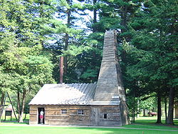 |
n/a | At Drake Well Museum, SE of Titusville 41.61168°N 79.65747°W |
Roadside | Business & Industry, Oil & Gas |
| Drake Well Park Oil Creek State Park Oil Creek State Park is Pennsylvania state park on in Cherrytree, Cornplanter and Oil Creek Township Townships, Venango County, Pennsylvania in the United States. The park is adjacent to Drake Well Museum, the site of the first successful oil well in the United States, that was drilled under the... |
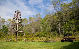 |
At Drake Well Museum, SE of Titusville °N °W |
Roadside | Business & Industry, Oil & Gas | |
| First Oil Pipeline | Pa. 227, 4 miles SW of Pleasantville 41.54152°N 79.61088°W |
Roadside | Business & Industry, Oil & Gas, Transportation | ||
| Fort Franklin | 13th St. (U.S. 322) & Franklin Ave., Franklin 41.40067°N 79.83112°W |
Roadside | American Revolution, Forts, Military | ||
| Fort Machault Fort Machault Fort Machault was a fort built by the French in 1754 near the confluence of French Creek with the Allegheny River, at present-day Franklin, in northwest Pennsylvania. The fort was part of a line that included Fort Presque Isle, Fort Le Boeuf, and Fort Duquesne.- Description:The fort was built on a... |
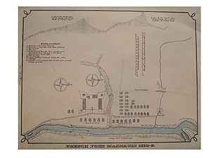 |
Elk St. & 8th St. (US 322), Franklin 41.38942°N 79.82225°W |
City | Forts, French & Indian War, Military | |
| Fort Venango Fort Venango Fort Venango was a small British fort built in 1760 near the site of present Franklin, Pennsylvania. The fort replaced Fort Machault, a French fort burned by the French in 1759 after they left the area near the end of the French and Indian War. On June 16, 1763, during Pontiac's Rebellion, the fort... |
Elk St. and 8th St. (US 322), Franklin 41.38932°N 79.82217°W |
City | Forts, French & Indian War, Military, Native American | ||
| Galena-Signal Oil Company | 1140 Liberty St., near co. courthouse, Franklin 41.39635°N 79.82718°W |
Roadside | Business & Industry, Oil & Gas, Railroads | ||
| George Bissell George Bissell (industrialist) George Henry Bissell is often considered the father of the American oil industry. He was born in Hanover, New Hampshire, the son of Isaac Bissell and Nancy Wemple.... |
Corner of Liberty & S Park Sts. in South Park, near co. courthouse, Franklin 41.3967°N 79.82705°W |
Roadside | Business & Industry, Oil & Gas, Professions & Vocations | ||
| Henry R. Rouse | Pa. 8 near S borough line of Rouseville 41.46858°N 79.69145°W |
Roadside | Business & Industry, Oil & Gas, Professions & Vocations | ||
| Humboldt Refinery | Masonic Hall, Plumer Village along SR 227 outside Oil City 41.48545°N 79.65248°W |
Roadside | Business & Industry, Invention, Oil & Gas | ||
| Jacob J. Vandergrift | Justus Park, Oil City °N °W |
Roadside | Business & Industry, Oil & Gas, Transportation | ||
| John Dewey John Dewey John Dewey was an American philosopher, psychologist and educational reformer whose ideas have been influential in education and social reform. Dewey was an important early developer of the philosophy of pragmatism and one of the founders of functional psychology... |
Central Ave. & W. 4th St., Oil City °N °W |
City | Education | ||
| John Franklin Carll (1826-1904) | 205 E State St., Pleasantville °N °W |
Roadside | Business & Industry, Medicine & Science, Oil & Gas, Professions & Vocations | ||
| John William Heisman (1869-1936) John Heisman John William Heisman was an American player and coach of football, basketball, and baseball. He served as the head football coach at Oberlin College , Buchtel College, now known as the University of Akron , Auburn University , Clemson University , Georgia Tech , the... |
adjacent to Carter Field, Central Ave. & Brown St., Titusville °N °W |
Roadside | Football, Sports | ||
| Johnny Appleseed Johnny Appleseed Johnny Appleseed , born John Chapman, was an American pioneer nurseryman who introduced apple trees to large parts of Ohio, Indiana, and Illinois... |
 |
13th St. (U.S. 322) & Franklin Ave., Franklin °N °W |
City | Agriculture, Folklore, Professions & Vocations | |
| Joseph Reid Gas Engine Company | Intersection of Main St. (Pa. 8), Halyday St. & Petroleum St., Oil City °N °W |
City | Business & Industry, Oil & Gas | ||
| Oil Well Supply Company | East Front St. (U.S. 62) & East First St., Oil City 41.4291°N 79.70908°W |
City | Business & Industry, Oil & Gas | ||
| Old Garrison | 10th & Liberty Sts. (on U.S. 322), Franklin °N °W |
Roadside | Military, Military Post-Civil War | ||
| Oldest Oil Producing Well | William Finn Hwy. (PA 8) at McClintock, just S of Rouseville 41.45902°N 79.69002°W |
Roadside | Business & Industry, Oil & Gas | ||
| Pithole | Pithole Rd. (SR 1006) at site 41.52487°N 79.5819°W |
Roadside | Environment | ||
| Pithole | Rouseville Rd. (PA 227) & Pithole Rd. (SR 1006), ~5 miles from both Pleasantville and Rouseville 41.51713°N 79.61913°W |
Roadside | Business & Industry, Oil & Gas | ||
| Pithole City | At site on Pithole Rd. (SR 1006) 41.52442°N 79.58177°W |
Roadside | Business & Industry, Oil & Gas | ||
| Samuel C. T. Dodd (1837-1907) | 1247 Liberty St. near Pennsylvania Alley, Franklin °N °W |
City | Government & Politics 20th Century, Oil & Gas, Professions & Vocations, Writers | ||
| Speechley Gas Pool Well | Rte. 157 & Twp. Road 60028, E of US62 junction & SE of Oil City °N °W |
Roadside | Business & Industry, Oil & Gas | ||
| Venango County Venango County, Pennsylvania Venango County is a county located in the U.S. state of Pennsylvania. As of the 2010 census, the population was 54,984. Its county seat is Franklin.-History:Venango County was created on March 12, 1800 from parts of Allegheny and Lycoming Counties... |
County Courthouse, 12th & Liberty Sts., Franklin 41.39742°N 79.82758°W |
City | Government & Politics, Government & Politics 19th Century | ||
| Venango Path Venango Path Venango Path was a Native American trail that ran from the Forks of the Ohio to Presque Isle, Pennsylvania, United States of America. The trail was named after the Native American village of Venango where French Creek empties into the Allegheny River... |
Old Rt. 8 (SR 3013) & Georgetown Rd. (SR 3003), just N of Wesley 41.23233°N 79.95628°W |
Roadside | George Washington, Native American, Paths & Trails, Transportation |
See also
- List of Pennsylvania state historical markers
- National Register of Historic Places listings in Venango County, PennsylvaniaNational Register of Historic Places listings in Venango County, PennsylvaniaThis is a list of the National Register of Historic Places listings in Venango County, Pennsylvania.This is intended to be a complete list of the properties and districts on the National Register of Historic Places in Venango County, Pennsylvania, United States...