

List of Pennsylvania state historical markers in Tioga County
Encyclopedia
This is intended to be a complete list of the official state historical markers placed in Tioga County, Pennsylvania
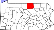
Tioga County, Pennsylvania
Tioga County is a county located in the U.S. state of Pennsylvania. As of the 2010 census, the population was 41,981. Tioga County was created on March 26, 1804, from part of Lycoming County and named for the Tioga River. Its county seat is Wellsboro....
by the Pennsylvania Historical and Museum Commission
Pennsylvania Historical and Museum Commission
The Pennsylvania Historical and Museum Commission is the governmental agency of the Commonwealth of Pennsylvania responsible for the collection, conservation and interpretation of Pennsylvania's historic heritage...
(PHMC). The locations of the historical markers, as well as the latitude and longitude coordinates as provided by the PHMC's database, are included below when available. There are 15 historical markers located in Tioga County.
Historical markers
| Marker title | Image | Date dedicated | Location | Marker type | Topics |
|---|---|---|---|---|---|
| Blossburg Coal | Pa. 287, 3.5 miles N of Morris 41.64056°N 77.30079°W |
Roadside | Business & Industry, Coal | ||
| Civilian Conservation Corps Civilian Conservation Corps The Civilian Conservation Corps was a public work relief program that operated from 1933 to 1942 in the United States for unemployed, unmarried men from relief families, ages 18–25. A part of the New Deal of President Franklin D... |
Leonard Harrison State Park, Wellsboro 41.69666°N 77.45168°W |
Roadside | Business & Industry, Environment, Government & Politics, Government & Politics 20th Century, Roads | ||
| Coal Discovery | n/a | U.S. 15 just S of Blossburg (Missing) °N °W |
Roadside | Business & Industry, Coal, Environment | |
| Corning & Blossburg Railroad | S. Main St. (Business U.S. 15), Mansfield 41.8049°N 77.07753°W |
City | Canals, Coal, Navigation, Railroads, Transportation | ||
| Nessmuk George W. Sears George Washington Sears was a sportswriter for Forest and Stream magazine in the 1880s and an early conservationist... |
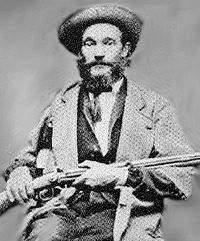 |
Courthouse Square, Pa. 660, Wellsboro 41.74671°N 77.30219°W |
Roadside | Environment, Writers | |
| Nessmuk George W. Sears George Washington Sears was a sportswriter for Forest and Stream magazine in the 1880s and an early conservationist... |
|
n/a | End of Pa. 660, Leonard Harrison State Park 41.69487°N 77.45433°W |
Roadside | Environment, Writers |
| Pine Creek Path Pine Creek Path The Pine Creek Path was a major Native American trail in the U.S. State of Pennsylvania that ran north along Pine Creek from the West Branch Susquehanna River near Long Island to the headwaters of the Genesee River .-Course:At the southern end of the trail there was a Native American village at... |
Grand Army of Republic Hwy. (US 6) near Rt. 362 junction, at Ansonia 41.74883°N 77.42421°W |
Roadside | Environment, Native American, Paths & Trails, Transportation | ||
| Rural Electrification Rural electrification Rural electrification is the process of bringing electrical power to rural and remote areas. Electricity is used not only for lighting and household purposes, but it also allows for mechanization of many farming operations, such as threshing, milking, and hoisting grain for storage; in areas... |
N. Main St. (Business U.S. 15), Mansfield 41.8078°N 77.07818°W |
Roadside | Agriculture, Business & Industry, Electricity | ||
| Sheshequin Path Sheshequin Path The Sheshequin Path was a major Native American trail in the U.S. State of Pennsylvania that ran between two Native American villages: "French Margaret's Town" on the West Branch Susquehanna River and "Sheshequin" on the North Branch of the Susquehanna River... |
Pa. 14, 3.6 miles NE of Roaring Branch (Missing) °N °W |
Roadside | Early Settlement, Native American, Paths & Trails, Transportation | ||
| Tioga County Tioga County, Pennsylvania Tioga County is a county located in the U.S. state of Pennsylvania. As of the 2010 census, the population was 41,981. Tioga County was created on March 26, 1804, from part of Lycoming County and named for the Tioga River. Its county seat is Wellsboro.... |
Courthouse Square, Pa. 287 & 660, Wellsboro 41.71687°N 77.30314°W |
City | Government & Politics, Government & Politics 19th Century, Native American | ||
| William A. Stone William A. Stone William Alexis Stone was the 22nd Governor of Pennsylvania from 1899 to 1903.-Early life:Stone was born in Wellsboro, Pennsylvania. In 1864, Stone enlisted in the Union Army as a private during the American Civil War, and became a second lieutenant in 1865. He continued his military service after... |
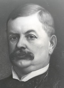 |
Courthouse Square, Central Ave. (PA 287) & Main St. (PA 660), Wellsboro 41.74723°N 77.30209°W |
Roadside | Government & Politics, Government & Politics 19th Century, Governors, Professions & Vocations | |
| William A. Stone William A. Stone William Alexis Stone was the 22nd Governor of Pennsylvania from 1899 to 1903.-Early life:Stone was born in Wellsboro, Pennsylvania. In 1864, Stone enlisted in the Union Army as a private during the American Civil War, and became a second lieutenant in 1865. He continued his military service after... |
|
Pa. 362, 3.5 miles SW of Wellsboro 41.73165°N 77.38037°W |
Roadside | Government & Politics, Government & Politics 19th Century, Governors, Professions & Vocations | |
| William B. Wilson William Bauchop Wilson William Bauchop Wilson was a American labor leader and politician. He is best remembered for his service as the first Secretary of Labor between 1913 and 1921 under President Woodrow Wilson.-Early life:... |
U.S. 15 just S of Blossburg 41.66778°N 77.07787°W |
Roadside | Coal, Ethnic & Immigration, Government & Politics, Government & Politics 20th Century, Labor | ||
| Williamson Road | Business U.S. 15 S of Mansfield at Canoe Camp (Missing) 41.78296°N 77.06973°W |
Roadside | Labor, Roads, Transportation | ||
| Williamson Road | SR 2005 (old U.S. 15) S of Liberty 41.55901°N 77.10533°W |
Roadside | Labor, Roads, Transportation |
See also
- List of Pennsylvania state historical markers
- National Register of Historic Places listings in Tioga County, PennsylvaniaNational Register of Historic Places listings in Tioga County, PennsylvaniaThis is a list of the National Register of Historic Places listings in Tioga County, Pennsylvania.This is intended to be a complete list of the properties and districts on the National Register of Historic Places in Tioga County, Pennsylvania, United States...