

List of Pennsylvania state historical markers in Pike County
Encyclopedia
This is intended to be a complete list of the official state historical markers placed in Pike County, Pennsylvania
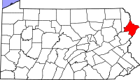
Pike County, Pennsylvania
-National protected areas:* Delaware Water Gap National Recreation Area * Middle Delaware National Scenic River * Upper Delaware Scenic and Recreational River -Demographics:...
by the Pennsylvania Historical and Museum Commission
Pennsylvania Historical and Museum Commission
The Pennsylvania Historical and Museum Commission is the governmental agency of the Commonwealth of Pennsylvania responsible for the collection, conservation and interpretation of Pennsylvania's historic heritage...
(PHMC). The locations of the historical markers, as well as the latitude and longitude coordinates as provided by the PHMC's database, are included below when available. There are 19 historical markers located in Pike County.
Historical markers
| Marker title | Image | Date dedicated | Location | Marker type | Topics |
|---|---|---|---|---|---|
| Battle of Minisink Battle of Minisink The Battle of Minisink was a battle of the American Revolutionary War fought at Minisink Ford, New York, on July 22, 1779. It was the only major skirmish of the Revolutionary War fought in the northern Delaware Valley... |
Lackawaxen Scenic Dr. (old PA 590) @ PA side of Minisink Ford & Roebling Bridge, N of Lackawaxen 41.48196°N 74.98652°W |
Roadside | American Revolution, Military, Native American | ||
| Charles S. Peirce | US 6 & 209, ~2 mi. NE of Milford 41.34085°N 74.7657°W |
Roadside | Medicine & Science, Professions & Vocations | ||
| Civil War Prison Train Wreck Shohola train wreck The Great Shohola train wreck occurred on July 15, 1864 during the American Civil War on the broad gauge Erie Railroad 1½ miles west of Shohola, Pennsylvania and killed at least 60 people. Aboard the 18 car train were 833 Confederate prisoners of war and 128 Union guards from the Veteran Reserve... |
PA 434 at Red Caboose, N end of Shohola 41.47209°N 74.91725°W |
Roadside | Civil War, Coal, Military, Railroads, Transportation | ||
| Dingmans Ferry | US 209, ~50 yds. N of Rt. 739 at Dingmans Ferry 41.22375°N 74.87045°W |
Roadside | Early Settlement, Transportation | ||
| Fort Hyndshaw | n/a | US 209 S of Bushkill at former LR 45068 (Missing) °N °W |
Roadside | Forts, French & Indian War, Military | |
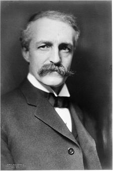
| Gifford Pinchot Gifford Pinchot Gifford Pinchot was the first Chief of the United States Forest Service and the 28th Governor of Pennsylvania... |
 |
n/a | US6 at I-84 interchange, NW of Milford 41.3393°N 74.83841°W |
Roadside | Environment, Government & Politics 20th Century, Governors |
| Gifford Pinchot Gifford Pinchot Gifford Pinchot was the first Chief of the United States Forest Service and the 28th Governor of Pennsylvania... |
U.S. 209 S of Milford 41.31442°N 74.80068°W |
Roadside | Environment, Government & Politics, Governors | ||
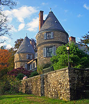
| Gifford Pinchot (1865-1946) Grey Towers National Historic Site Grey Towers National Historic Site, also known as Gifford Pinchot House or The Pinchot Institute, is located just off US 6 west of Milford, Pennsylvania, in Dingman Township... |
 |
Just off US 6 (Owega Tunrpike), near Pine Acres Rd., NW of Milford (follow signs to Grey Towers) 41.32809°N 74.81332°W |
Roadside | Environment, Government & Politics, Governors | |
| Hotel Fauchere | Broad & Catherine Sts., Milford 41.32383°N 74.80119°W |
Roadside | Buildings, Business & Industry, Inns & Taverns | ||
| Old Stone Fort | 1st St. , between Deevand Circle & Ave. P (several blocks S of US 6 & 209), Matamoras 41.36793°N 74.69468°W |
Roadside | Early Settlement, Ethnic & Immigration, Forts, Military, Native American | ||
| Pike County Pike County, Pennsylvania -National protected areas:* Delaware Water Gap National Recreation Area * Middle Delaware National Scenic River * Upper Delaware Scenic and Recreational River -Demographics:... |
County Courthouse, Broad & W High Sts., Milford 41.32445°N 74.80071°W |
City | Government & Politics, Government & Politics 19th Century | ||
| Sylvania Colony | Junction US 6 at PA 434, ~2 mi. S of Greeley 41.40067°N 75.00959°W |
Roadside | Cities & Towns, Environment, Government & Politics, Government & Politics 19th Century | ||
| Sylvania Colony | PA 434, ~100 yds. from PA 590 junction, Greeley 41.41783°N 74.9951°W |
Roadside | Cities & Towns, Environment, Government & Politics, Government & Politics 19th Century, Labor | ||
| Unity House | Bushkill Falls Road at Unity House entrance, Bushkill Falls (Missing) °N °W |
Roadside | Buildings, Business & Industry, Government & Politics 20th Century, Labor | ||
| Wallenpaupack | Pa. 507 at Paupack (Missing) °N °W |
Roadside | Early Settlement, Government & Politics, Government & Politics 18th Century | ||
| Wyoming-Minisink Path | U.S. 209, 3 miles S of Milford, ~75 yds S of Raymondskill Rd. 41.28669°N 74.83422°W |
Roadside | Early Settlement, Native American, Paths & Trails, Transportation | ||
| Wyoming-Minisink Path | Blooming Grove Rd. (LR 51019 / SR 4004) @ Spring Rd., .3 mile W of Lords Valley °N °W |
Roadside | Native American, Paths & Trails, Transportation | ||
| Wyoming-Minisink Path | PA 507 (E side), 1.4 mi. W of LR 51028 at Paupack (Missing) °N °W |
Roadside | Paths & Trails, Transportation | ||
| Zane Grey (1872-1939) Zane Grey Zane Grey was an American author best known for his popular adventure novels and stories that presented an idealized image of the Old West. Riders of the Purple Sage was his bestselling book. In addition to the success of his printed works, they later had second lives and continuing influence... |
At Zane Grey Museum, Scenic Dr., just off PA 590, N end of Lackawaxen 41.48584°N 74.98719°W |
City | Writers |
See also
- List of Pennsylvania state historical markers
- National Register of Historic Places listings in Pike County, PennsylvaniaNational Register of Historic Places listings in Pike County, PennsylvaniaThis is a list of the National Register of Historic Places listings in Pike County, Pennsylvania.This is intended to be a complete list of the properties and districts on the National Register of Historic Places in Pike County, Pennsylvania, United States...