

List of Pennsylvania state historical markers in Jefferson County
Encyclopedia
This is intended to be a complete list of the official state historical markers placed in Jefferson County, Pennsylvania
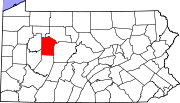
Jefferson County, Pennsylvania
Jefferson County is a county located in the U.S. state of Pennsylvania. In 2010, its population was 45,200. It was established on March 26, 1804, from part of Lycoming County and named for then-President Thomas Jefferson. Its county seat is Brookville...
by the Pennsylvania Historical and Museum Commission
Pennsylvania Historical and Museum Commission
The Pennsylvania Historical and Museum Commission is the governmental agency of the Commonwealth of Pennsylvania responsible for the collection, conservation and interpretation of Pennsylvania's historic heritage...
(PHMC). The locations of the historical markers, as well as the latitude and longitude coordinates as provided by the PHMC's database, are included below when available. There are nine historical markers located in Jefferson County.
Historical markers
| Marker title | Image | Date dedicated | Location | Marker type | Topics |
|---|---|---|---|---|---|
| CHARLES J. MARGIOTTI (1891–1956) | Calvary Cemetery, 444 S Main St. (Rt. 436), Punxsutawney 40.93639°N 78.99108°W |
Roadside | Ethnic & Immigration, Government & Politics 20th Century, Professions & Vocations | ||
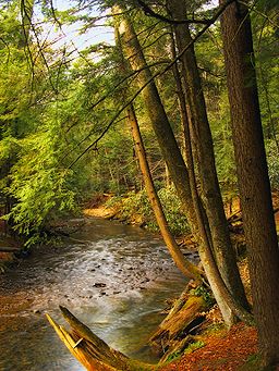
| Cooksburg Cook Forest State Park Cook Forest State Park is a Pennsylvania state park in Farmington Township, Clarion County, Barnett Township, Forest County and Barnett Township, Jefferson County, Pennsylvania in the United States. The park is a heavily wooded area of rolling hills and mountains along the Clarion River in... |
 |
Pa. 36 near Clarion River Bridge, Corsica (Missing) °N °W |
Roadside | Cities & Towns, Environment | |
| Elijah Heath (1796–1875) | 64 S. Pickering St., Brookville 41.15965°N 79.0798°W |
City | African American, Underground Railroad | ||
| Great Shamokin Path Great Shamokin Path The Great Shamokin Path was a major Native American trail in the U.S. State of Pennsylvania that ran from the native village of Shamokin along the left bank of the West Branch Susquehanna River north and then west to the Great Island... |
US 119, 4 miles (6.4 km) NE of Punxsutawney 40.96348°N 78.91115°W |
Roadside | French & Indian War, Native American, Paths & Trails, Religion, Transportation | ||
| Groundhog Day Groundhog Day Groundhog Day is a holiday celebrated on February 2 in the United States and Canada. According to folklore, if it is cloudy when a groundhog emerges from its burrow on this day, it will leave the burrow, signifying that winter-like weather will soon end... |
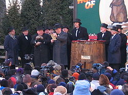 |
At Gobbler's Knob, Woodland Ave., 1.2 miles (1.9 km) from Route 36, Punxsutawney 40.931282°N 78.95768°W |
Roadside | Ethnic & Immigration, Folklore, Religion | |
| Iroquois "Main Road" | Pa. 949, 3.8 miles (6.1 km) N of Corsica (Missing) °N °W |
Roadside | Native American, Paths & Trails, Roads, Transportation | ||
| Jefferson County Jefferson County, Pennsylvania Jefferson County is a county located in the U.S. state of Pennsylvania. In 2010, its population was 45,200. It was established on March 26, 1804, from part of Lycoming County and named for then-President Thomas Jefferson. Its county seat is Brookville... |
County Courthouse, Main St. (Rt. 28) at Pickering, Brookville 41.16063°N 79.08019°W |
City | Government & Politics, Government & Politics 19th Century | ||
| Lewis Earle Sandt (1888–1913) | 42 S Pickering St., Brookville °N °W |
City | Exploration, Navigation, Transportation | ||
| Olean Road | Main St. (US 322), near Olean Rd. (Rt. 949), Corsica 41.1809°N 79.2035°W |
Roadside | Native American, Roads, Transportation |
See also
- List of Pennsylvania state historical markers
- National Register of Historic Places listings in Jefferson County, PennsylvaniaNational Register of Historic Places listings in Jefferson County, PennsylvaniaThis is a list of the National Register of Historic Places listings in Jefferson County, Pennsylvania.This is intended to be a complete list of the properties and districts on the National Register of Historic Places in Jefferson County, Pennsylvania, United States...