

List of Pennsylvania state historical markers in Columbia County
Encyclopedia
This is intended to be a complete list of the official state historical markers placed in Columbia County, Pennsylvania
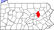
Columbia County, Pennsylvania
As of the census of 2000, there were 64,151 people, 24,915 households, and 16,568 families residing in the county. The population density was 132 people per square mile . There were 27,733 housing units at an average density of 57 per square mile...
by the Pennsylvania Historical and Museum Commission
Pennsylvania Historical and Museum Commission
The Pennsylvania Historical and Museum Commission is the governmental agency of the Commonwealth of Pennsylvania responsible for the collection, conservation and interpretation of Pennsylvania's historic heritage...
(PHMC). The locations of the historical markers, as well as the latitude and longitude coordinates as provided by the PHMC's database, are included below when available. There are eight historical markers located in Columbia County.
Historical markers
| Marker title | Image | Date dedicated | Location | Marker type | Topics |
|---|---|---|---|---|---|
| Catawissa Friends Meeting Catawissa Friends Meetinghouse Catawissa Friends Meetinghouse is a historic Quaker meeting house at South and 3rd Streets in Catawissa, Pennsylvania.It was built in 1789 of log construction and was added to the National Register in 1978.... |
Junction U.S. 11 & Pa. 42, .7 mile SW of Bloomsburg °N °W |
Roadside | Buildings, Early Settlement, Religion | ||
| Catawissa Friends Meeting Catawissa Friends Meetinghouse Catawissa Friends Meetinghouse is a historic Quaker meeting house at South and 3rd Streets in Catawissa, Pennsylvania.It was built in 1789 of log construction and was added to the National Register in 1978.... |
South St. between 3rd & 4th Sts., Catawissa 40.95087°N 76.46143°W |
Roadside | Buildings, Early Settlement, Religion | ||
| Columbia County Columbia County, Pennsylvania As of the census of 2000, there were 64,151 people, 24,915 households, and 16,568 families residing in the county. The population density was 132 people per square mile . There were 27,733 housing units at an average density of 57 per square mile... |
County Courthouse, Main St., Bloomsburg 41.00305°N 76.45707°W |
City | Bridges, Cities & Towns, Government & Politics, Government & Politics 19th Century, Religion | ||
| Fishing Creek Confederacy | 90 Mill St. (PA 487), Benton, PA 41.1918°N 76.3836°W |
Roadside | Abraham Lincoln, Civil War, Forts, Government & Politics 19th Century, Military | ||
| Fort Jenkins | Old U.S. 11, 6.5 miles NE of Bloomsburg °N °W |
Roadside | American Revolution, Forts, Government & Politics 18th Century, Military, Native American | ||
| Fort McClure | U.S. 11 at Fairgrounds, Bloomsburg °N °W |
Roadside | American Revolution, Early Settlement, Forts, Military, Native American | ||
| Fort Wheeler | Pa. 487, 1.2 miles NE of Bloomsburg 41.02542°N 76.42947°W |
Roadside | American Revolution, Forts, Military, Native American | ||
| Wyoming Path | W 2nd St. (US 11) near W Ft. McClure Blvd., at Fairgrounds, Bloomsburg 40.99448°N 76.4731°W |
Roadside | Native American, Paths & Trails, Religion, Transportation |
See also
- List of Pennsylvania state historical markers
- National Register of Historic Places listings in Columbia County, PennsylvaniaNational Register of Historic Places listings in Columbia County, PennsylvaniaThis is a list of the National Register of Historic Places listings in Columbia County, Pennsylvania.This is intended to be a complete list of the properties and districts on the National Register of Historic Places in Columbia County, Pennsylvania, United States...