

List of Pennsylvania state historical markers in Clarion County
Encyclopedia

This is intended to be a complete list of the official state historical markers placed in Clarion County, Pennsylvania
Clarion County, Pennsylvania
As of the census of 2000, there were 41,765 people, 16,052 households, and 10,738 families residing in the county. The population density was 69 people per square mile . There were 19,426 housing units at an average density of 32 per square mile...
by the Pennsylvania Historical and Museum Commission
Pennsylvania Historical and Museum Commission
The Pennsylvania Historical and Museum Commission is the governmental agency of the Commonwealth of Pennsylvania responsible for the collection, conservation and interpretation of Pennsylvania's historic heritage...
(PHMC). The locations of the historical markers, as well as the latitude and longitude coordinates as provided by the PHMC's database, are included below when available. There are seven historical markers located in Clarion County.
Historical markers
| Marker title | Image | Date dedicated | Location | Marker type | Topics |
|---|---|---|---|---|---|
| Brady's Bend | Pa. 68, 1.3 miles E of Brady's Bend at Lookout 40.98807°N 79.58303°W |
Roadside | American Revolution, Military, Native American | ||
| Buchanan Furnace Buchanan Furnace The Buchanan Furnace in Callensburg, Pennsylvania is a building from 1844. It was listed on the National Register of Historic Places in 1991.... |
Jct. Pa. 58 & Pa. 368 at Callensburg 41.12722°N 79.5504°W |
Roadside | Business & Industry, Coal, Furnaces, Iron | ||
| Clarion County Clarion County, Pennsylvania As of the census of 2000, there were 41,765 people, 16,052 households, and 10,738 families residing in the county. The population density was 69 people per square mile . There were 19,426 housing units at an average density of 32 per square mile... |
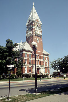 |
Courthouse, Main St. at 5th Ave., Clarion 41.21508°N 79.38612°W |
City | Business & Industry, Coal, Government & Politics, Government & Politics 19th Century, Iron | |
| Fishbasket Old Town | Rte. 28, Alcola, near Redland Valley Park 41.01255°N 79.29402°W |
Roadside | Cities & Towns, Early Settlement, Native American, Paths & Trails | ||
| Foxburg Golf Course Foxburg Country Club Foxburg Country Club, established in 1887, is the oldest golf course "in continuous use" in the United States. It was listed as Foxburg Country Club and Golf Course on the National Register of Historic Places... |
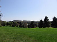 |
Pa. 58 at NE end of Foxburg 41.14648°N 79.67977°W |
Roadside | Sports | |
| Helen Furnace | SR 1005 (old Pa. 966) 7 miles NE of Clarion 41.28748°N 79.31855°W |
Roadside | Business & Industry, Coal, Furnaces, Iron | ||
| Rural Electrification Rural electrification Rural electrification is the process of bringing electrical power to rural and remote areas. Electricity is used not only for lighting and household purposes, but it also allows for mechanization of many farming operations, such as threshing, milking, and hoisting grain for storage; in areas... |
PA 368 near Terwilliger Rd., 1 mile E of Parker 41.10102°N 79.66488°W |
Roadside | Business & Industry, Electricity |
See also
- List of Pennsylvania state historical markers
- National Register of Historic Places listings in Clarion County, PennsylvaniaNational Register of Historic Places listings in Clarion County, PennsylvaniaThis is a list of the National Register of Historic Places listings in Clarion County, Pennsylvania.This is intended to be a complete list of the properties and districts on the National Register of Historic Places in Clarion County, Pennsylvania, United States...