

List of Pennsylvania state historical markers in Carbon County
Encyclopedia
This is intended to be a complete list of the official state historical markers placed in Carbon County, Pennsylvania
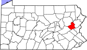
Carbon County, Pennsylvania
As of the census of 2000, there were 58,802 people, 23,701 households, and 16,424 families residing in the county. The population density was 154 people per square mile . There were 30,492 housing units at an average density of 80 per square mile...
by the Pennsylvania Historical and Museum Commission
Pennsylvania Historical and Museum Commission
The Pennsylvania Historical and Museum Commission is the governmental agency of the Commonwealth of Pennsylvania responsible for the collection, conservation and interpretation of Pennsylvania's historic heritage...
(PHMC). The locations of the historical markers, as well as the latitude and longitude coordinates as provided by the PHMC's database, are included below when available. There are 11 historical markers located in Carbon County.
Historical markers
| Marker title | Image | Date dedicated | Location | Marker type | Topics |
|---|---|---|---|---|---|
| Carbon County Carbon County, Pennsylvania As of the census of 2000, there were 58,802 people, 23,701 households, and 16,424 families residing in the county. The population density was 154 people per square mile . There were 30,492 housing units at an average density of 80 per square mile... |
County Courthouse, Broadway & Susquehanna Sts., Jim Thorpe 40.8637°N 75.73802°W |
City | Environment, Government & Politics, Government & Politics 19th Century, Native American | ||
| Fort Allen | U.S. 209 in Franklin Twp. (near Weissport), near Wachovia Bank 40.83081°N 75.69591°W |
Roadside | Forts, French & Indian War, Military | ||
| Fort Allen Well | Park opposite 112-116 Franklin St., Weissport 40.82966°N 75.70248°W |
City | American Revolution, Environment, Forts, Military | ||
| Gnadenhuetten Lehighton, Pennsylvania Lehighton is a borough in Carbon County, Pennsylvania, north by west of Philadelphia. In the past, it developed early industries because of water power from the Lehigh River. With the location of a repair facility here and its regional operations, the Lehigh Valley Railroad became for years a... |
Penn Street in Lehighton, just north of Boro. Garage °N °W |
Roadside | Early Settlement, Native American, Religion | ||
| Molly Maguire Executions | at Old Carbon County Jail, Broadway, Jim Thorpe °N °W |
Roadside | Business & Industry, Coal, Government & Politics 19th Century, Labor | ||
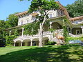
| Packer Mansion Asa Packer Mansion The Asa Packer Mansion, in Jim Thorpe, Pennsylvania, was the home of Asa Packer , coal and railroad magnate and founder of Lehigh University. It is one of the best preserved Italianate Villa homes in the United States.-History:... |
 |
Susquehanna St. (US 209) at park near railroad station, Jim Thorpe 40.86324°N 75.73777°W |
Roadside | Buildings, Mansions & Manors, Professions & Vocations | |
| Philip Ginter | Ludlow Park on E Penn St., Summit Hill 40.8244°N 75.87324°W |
City | Business & Industry, Coal | ||
| Switchback Railroad | 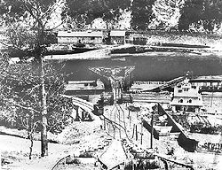 |
SR 3012, 3 miles SW of Jim Thorpe 40.8438°N 75.80616°W |
Roadside | Railroads, Transportation | |
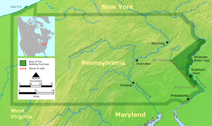
| Walking Purchase Walking Purchase The Walking Purchase was a purported 1737 agreement between the Penn family, the proprietors of Pennsylvania, and the Lenape . By it the Penn family and proprietors claimed an area of 1,200,000 acres and forced the Lenape to vacate it... |
 |
Interchange Rd.(US 209) near Rock St. and Main Rd., 1.5 miles E of Weissport 40.8386°N 75.67585°W |
Roadside | Government & Politics, Government & Politics 18th Century, Native American, Paths & Trails | |
| Walking Purchase Walking Purchase The Walking Purchase was a purported 1737 agreement between the Penn family, the proprietors of Pennsylvania, and the Lenape . By it the Penn family and proprietors claimed an area of 1,200,000 acres and forced the Lenape to vacate it... |
|
PA 903 near Maury Rd. (SR 2017), 2 miles NE of Jim Thorpe 40.89526°N 75.69046°W |
Roadside | Government & Politics, Government & Politics 18th Century, Native American | |
| Walking Purchase | |
Pa. 903, 2 miles NE of Jim Thorpe °N °W |
Roadside | Government & Politics, Government & Politics 17th Century, Native American |
See also
- List of Pennsylvania state historical markers
- National Register of Historic Places listings in Carbon County, PennsylvaniaNational Register of Historic Places listings in Carbon County, PennsylvaniaThis is a list of the National Register of Historic Places listings in Carbon County, Pennsylvania.This is intended to be a complete list of the properties and districts on the National Register of Historic Places in Carbon County, Pennsylvania, United States...