

List of Pennsylvania state historical markers in Bedford County
Encyclopedia
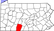
This is intended to be a complete list of the official state historical markers placed in Bedford County, Pennsylvania
Bedford County, Pennsylvania
Bedford County is a county located in the U.S. state of Pennsylvania. As of the 2010 census, the population was 49,762. The county seat is Bedford. It is part of the Altoona, Pennsylvania, Metropolitan Statistical Area.- History :...
by the Pennsylvania Historical and Museum Commission
Pennsylvania Historical and Museum Commission
The Pennsylvania Historical and Museum Commission is the governmental agency of the Commonwealth of Pennsylvania responsible for the collection, conservation and interpretation of Pennsylvania's historic heritage...
(PHMC). The locations of the historical markers, as well as the latitude and longitude coordinates as provided by the PHMC's database, are included below when available. There are 31 historical markers located in Bedford County.
Historical markers
| Marker title | Image | Date dedicated | Location | Marker type | Topics |
|---|---|---|---|---|---|
| Anderson House | E. Pitt St. between Juliana & Richard Sts., Bedford 40.01912°N 78.50235°W |
City | Buildings, Business & Industry, Houses & Homesteads | ||
| Bedford County Bedford County, Pennsylvania Bedford County is a county located in the U.S. state of Pennsylvania. As of the 2010 census, the population was 49,762. The county seat is Bedford. It is part of the Altoona, Pennsylvania, Metropolitan Statistical Area.- History :... |
Courthouse, S. Juliana & Penn Sts., Bedford 40.01752°N 78.50367°W |
City | Forts, French & Indian War, Government & Politics, Government & Politics 18th Century, Roads | ||
| Bedford Springs Bedford Springs Hotel Historic District The Bedford Springs Hotel Historic District is a historic district in Bedford, Pennsylvania, encompassing the grounds of a historic mineral springs resort... |
Business U.S. 220, Bedford Springs 39.9963°N 78.50683°W |
Roadside | Business & Industry, Cities & Towns, Government & Politics 19th Century, Medicine & Science | ||
| Bedford Village Bedford, Pennsylvania Bedford is a borough in Bedford County, Pennsylvania, west of the State Capital, Harrisburg. It is the county seat of Bedford County. Bedford was established in the mid-18th century. Population counts follow: 1890, 2,242; 1900, 2,167; 1910, 2,385. The population was 3,141 at the 2000... |
n/a | Old main highways leading into Bedford 40.01862°N 78.49145°W |
Roadside | Early Settlement, Forts, French & Indian War, George Washington, Military, Whiskey Rebellion | |
| Benjamin Walker Homestead | 407 Rainbow Dr., Alum Bank, PA 15521, 1.5 mi. N of Pleasantville - Rt. 56 onto Beutman Rd., .5 mi. N to location °N °W |
Roadside | African American, Civil War, Underground Railroad | ||
| Bonnet Tavern | Jct. U.S. 30/Pa. 31, 4 miles W of Bedford 40.04222°N 78.56042°W |
Roadside | George Washington, Military, Inns & Taverns, Whiskey Rebellion | ||
| Capt. Phillips' Rangers Memorial | At site, Pa. 26, 2 miles NW of Saxton °N °W |
Roadside | American Revolution, Military, Native American | ||
| Espy House Espy House Espy House, also known as David Espy House or Gen. Arthur St. Clair Office is a house in Bedford, Pennsylvania. The house is significant for its association with American Revolutionary War General Arthur St... |
E. Pitt St. between Juliana & Richard Sts., Bedford 40.0191°N 78.50288°W |
City | American Revolution, George Washington, Houses & Homesteads, Military, Whiskey Rebellion | ||
| Forbes Camp | U.S. 30 W of Schellsburg 40.04882°N 78.64787°W |
Roadside | French & Indian War, Military | ||
| Forbes Road Forbes Road The Forbes Road was a historic military roadway in what was then British America, that was constructed in 1758 from Carlisle, Pennsylvania, to the French Fort Duquesne at the junction of the Allegheny and Monongahela rivers in what is now downtown Pittsburgh... |
Jct. U.S. 30 & Pa. 31, 4 miles W of Bedford 40.04283°N 78.56°W |
Roadside | French & Indian War, Roads, Transportation | ||
| Forbes Road - Washington & Bouquet Meeting | Bedford Valley Rd. (Rt. 220) between Providence Lutheran Church and Goodness Grows Landscaping, 2 miles N of Centerville °N °W |
Roadside | French & Indian War, George Washington, Military, Roads | ||
| Forbes Road (Fort Juniata) | U.S. 30, 6.2 miles E of Everett 39.99598°N 78.26857°W |
Roadside | French & Indian War, Military, Roads, Transportation | ||
| Forbes Road, 1758, Fort Bedford to Fort Duquesne - Fort Bedford-Raystown (PLAQUE) | n/a | On wall at NW corner Pitt & Juliana Sts., Bedford 40.01903°N 78.50425°W |
Plaque | Forts, French & Indian War, Military, Roads | |
| Forbes Road, 1758, Fort Bedford to Fort Duquesne - Fort Dewart McLeans' Encampment (PLAQUE) | n/a | US 30, opposite old shot factory at curve at bottom of hill leading to Ship Hotel, just E of Somerset Co. line (MISSING) °N °W |
Plaque | Forts, French & Indian War, Military, Roads | |
| Forbes Road, 1758, Fort Bedford to Fort Duquesne - Shawnee Cabins Encampment (PLAQUE) | n/a | US 30 at W edge Schellsburg 40.0488°N 78.64765°W |
Plaque | French & Indian War, Military, Roads | |
| Forbes Road, 1758, Fort Bedford to Fort Duquesne - The Forks (PLAQUE) | n/a | Junction US 30 & PA 31, 4 miles W of Bedford 40.04285°N 78.55983°W |
Plaque | French & Indian War, Military, Roads | |
| Fort Bedford Fort Bedford Fort Bedford was a French and Indian War-era British military fortification located at the present site of Bedford, Pennsylvania. The fort was a star-shaped log fortress erected in the summer of 1758.-Background:... |
U.S. 30 near site in Bedford 40.201017°N 78.50467°W |
Roadside | Forts, French & Indian War, Military | ||
| Fraser Tavern | NE corner E. Pitt & Richard Sts., Bedford 40.0192°N 78.50162°W |
City | Buildings, Business & Industry, George Washington, Inns & Taverns | ||
| Gettysburg Campaign Gettysburg Campaign The Gettysburg Campaign was a series of battles fought in June and July 1863, during the American Civil War. After his victory in the Battle of Chancellorsville, Confederate General Robert E. Lee's Army of Northern Virginia moved north for offensive operations in Maryland and Pennsylvania. The... |
SR 1005 (former Pa. 36 & LR 286) 5 miles S of Loysburg 40.1009°N 78.38953°W |
Roadside | Civil War, Military | ||
| King's House | E. Pitt St. between Juliana & Richard Sts., Bedford 40.01903°N 78.5034°W |
City | French & Indian War, Houses & Homesteads, Military | ||
| Old Log Church Old Log Church Old Log Church is a historic church in Riverside, Kentucky.It was built in 1891 and added to the National Register in 1979.... |
Lincoln Hwy. (US 30), near Cemetery Rd., just W of Schellsburg 40.04932°N 78.65545°W |
Roadside | Buildings, Religion | ||
| Pennsylvania Pennsylvania The Commonwealth of Pennsylvania is a U.S. state that is located in the Northeastern and Mid-Atlantic regions of the United States. The state borders Delaware and Maryland to the south, West Virginia to the southwest, Ohio to the west, New York and Ontario, Canada, to the north, and New Jersey to... |
 |
Pa. 96, 1000 ft. from state line °N °W |
Roadside | Government & Politics, Government & Politics 17th Century, William Penn | |
| Pennsylvania Pennsylvania The Commonwealth of Pennsylvania is a U.S. state that is located in the Northeastern and Mid-Atlantic regions of the United States. The state borders Delaware and Maryland to the south, West Virginia to the southwest, Ohio to the west, New York and Ontario, Canada, to the north, and New Jersey to... |
|
U.S. 220 , 1650 feet from state line 39.72573°N 78.70965°W |
Roadside | Government & Politics, Government & Politics 17th Century, William Penn | |
| Pennsylvania Turnpike Pennsylvania Turnpike The Pennsylvania Turnpike is a toll highway system operated by the Pennsylvania Turnpike Commission in the Commonwealth of Pennsylvania, United States. The three sections of the turnpike system total . The main section extends from Ohio to New Jersey and is long... |
n/a | South Midway Service Plaza, just W of Turnpike Exit 11, Bedford 40.03022°N 78.49312°W |
Roadside | Government & Politics 20th Century, Roads, Transportation | |
| Pennsylvania Turnpike Pennsylvania Turnpike The Pennsylvania Turnpike is a toll highway system operated by the Pennsylvania Turnpike Commission in the Commonwealth of Pennsylvania, United States. The three sections of the turnpike system total . The main section extends from Ohio to New Jersey and is long... |
n/a | North Midway Service Plaza just W of Turnpike exit 11, Bedford 40.03062°N 78.49203°W |
Roadside | Government & Politics 20th Century, Roads, Transportation | |
| Phillips' Rangers | Pa. 26, 2 miles NW of Saxton °N °W |
Roadside | American Revolution, Military, Native American | ||
| Rural Electrification Rural electrification Rural electrification is the process of bringing electrical power to rural and remote areas. Electricity is used not only for lighting and household purposes, but it also allows for mechanization of many farming operations, such as threshing, milking, and hoisting grain for storage; in areas... |
Pa. 869 at New Enterprise 40.01715°N 78.48547°W |
Roadside | Business & Industry, Electricity | ||
| Rural Electrification Rural electrification Rural electrification is the process of bringing electrical power to rural and remote areas. Electricity is used not only for lighting and household purposes, but it also allows for mechanization of many farming operations, such as threshing, milking, and hoisting grain for storage; in areas... |
E Pitt St. / Lincoln Hwy. (SR 4010 / old US 30) at Clark Bldg. & Donohue Manor Rds., .5 mile E of Bedford °N °W |
Roadside | Business & Industry, Electricity | ||
| Russell House Russell House (Bedford, Pennsylvania) Russell House, also known as Pate Funeral Home, is a historic home located at Bedford in Bedford County, Pennsylvania. It was built in 1815-1816, and is a 2 1/2-story, 5-bay by 3-bay, brick dwelling in the late-Georgian style. A two-story rear ell was added about 1840-1845... |
203 S. Juliana St., Bedford (Missing) °N °W |
City | Buildings, Government & Politics, Government & Politics 19th Century, Houses & Homesteads | ||
| Shawnee Cabins | US 30 near Mill Rd., W of Schellsburg 40.04873°N 78.6476°W |
Roadside | Early Settlement, Native American, Paths & Trails | ||
| The Squares | S. Juliana St. at W Penn St., Bedford 40.01738°N 78.50358°W |
Roadside | Government & Politics, Government & Politics 18th Century, William Penn |
See also
- List of Pennsylvania state historical markers
- National Register of Historic Places listings in Bedford County, PennsylvaniaNational Register of Historic Places listings in Bedford County, PennsylvaniaThis is a list of the National Register of Historic Places listings in Bedford County, Pennsylvania.This is intended to be a complete list of the properties and districts on the National Register of Historic Places in Bedford County, Pennsylvania, United States...