

List of Neighborhoods in Denver
Encyclopedia
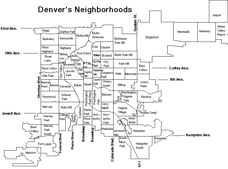
Denver, Colorado
The City and County of Denver is the capital and the most populous city of the U.S. state of Colorado. Denver is a consolidated city-county, located in the South Platte River Valley on the western edge of the High Plains just east of the Front Range of the Rocky Mountains...
, Colorado
Colorado
Colorado is a U.S. state that encompasses much of the Rocky Mountains as well as the northeastern portion of the Colorado Plateau and the western edge of the Great Plains...
, United States
United States
The United States of America is a federal constitutional republic comprising fifty states and a federal district...
:
- Alamo Placita
- Athmar ParkAthmar Park, Denver, ColoradoAthmar Park is an older neighborhood in southwest Denver, Colorado. It consists mostly of all-brick ranches and bungalow-style homes built in the 1940s and 1950s.- Demographics :...
- AurariaAuraria, Denver, ColoradoAuraria was a small mining settlement in the Kansas Territory in the United States. Today it survives in its original location as a neighborhood of Denver, Colorado, south of the confluence of Cherry Creek and the South Platte River.- History :...
- Baker
- BarnumBarnum, DenverBarnum is a neighborhood of Denver, Colorado. The neighborhood is located in the area known as West Denver. According to the Piton Foundation, in 2007, the population of the neighborhood was 6,456, and there were 1,924 housing units.-Demographics:...
- Barnum West
- Bear Valley
- BelcaroBelcaro, DenverBelcaro is a neighborhood of Denver, Colorado. According to the Piton Foundation, in 2007, the population of the neighborhood was 4,394, and there were 2,343 housing units...
- Berkeley
- Burns Brentwood
- Byers
- Capitol HillCapitol Hill, Denver, ColoradoLocated in the City and County of Denver, Colorado, the Capitol Hill neighborhood is bounded by Broadway, Downing Street, Colfax Avenue, and Seventh Avenue, which carry large volumes of traffic around the neighborhood. It is technically located in East Denver which begins immediately east of...
- Central Business DistrictDowntown DenverDowntown Denver is the main financial, commercial, and entertainment district in Denver, Colorado. There is over of office space in downtown Denver, with 130,000 workers....
- Chaffee ParkChaffee Park, DenverChaffee Park is a neighborhood of Denver, Colorado. It is in the area known to many as North Denver. It was platted in 1946 and mostly completed by 1949. It is named after Jerome B. Chaffee, one of the founders of the City of Denver and Republican U.S. Senator from 1871 to 1875...
- Cheesman ParkCheesman Park, DenverCheesman Park is an urban park and neighborhood located in the City and County of Denver, Colorado, United States.-Geography:Cheesman Park is located in central Denver, southeast of downtown...
- Cherry Creek
- City Park
- City Park WestCity Park West, DenverCity Park West is a neighborhood of Denver, Colorado. It is in the area known as East Denver, or the "East Side". According to the Piton Foundation, in 2007, the population of the neighborhood was 4,120 and there were 2,734 housing units...
- Civic Center
- Clayton
- ColeCole, DenverCole is a neighborhood of Denver, Colorado. It is in the area commonly known as East Denver, or the "East Side".According to the Piton Foundation, in 2007, the population of the neighborhood was 6,041, and there were 1,794 housing units...
- College View
- Congress ParkCongress Park, DenverCongress Park is a park and a neighborhood in the City and County of Denver, Colorado. In 2007, the neighborhood had 11,247 residents and 6,388 housing units.-Boundaries:...
- Cory-Merrill
- Country ClubCountry Club, DenverCountry Club is a neighborhood of Denver, Colorado. According to the Piton Foundation, "The Country Club neighborhood is bounded by University Boulevard, Cherry Creek, Downing Street, and 8th Avenue. Two main features of the neighborhood are the Denver Country Club and Country Club Place...
- Crestmoor
- Curtis Park
- Denver International AirportDenver International AirportDenver International Airport , often referred to as DIA, is an airport in Denver, Colorado. By land size, at , it is the largest international airport in the United States, and the third largest international airport in the world after King Fahd International Airport and Montréal-Mirabel...
- East Colfax
- East Highlands
- Elyria-SwanseaElyria-Swansea, DenverElyria-Swansea is a neighborhood of Denver, Colorado. It is located in East Denver, on the northeast side of the city. In 2007, the neighborhood had 7,218 residents and 1,787 households...
- Five Points
- Fort Logan
- Gateway
- GlobevilleGlobeville, DenverGlobeville is a neighborhood of Denver, Colorado. Globeville is located in the area traditionally called North Denver.-Boundaries:According to a document entitled, Globeville Neighborhood Assessment, prepared by the Denver Department of Planning and Community Development in 2008, "Globeville is...
- Golden Triangle
- Goldsmith
- Green Valley Ranch
- HaleHale, Denver, ColoradoThe Hale neighborhood is a designated statistical neighborhood in the City and County of Denver, Colorado. Its boundaries are Colfax Avenue to the north, 6th Avenue to the south, Colorado Boulevard to the west, and Holly Street to the east....
- Hampden
- Hampden Heights
- Hampden SouthHampden South, Denver, ColoradoHampden South is a neighborhood in Denver, Colorado, United States.Sumitomo Corporation operates its Denver office in Suite 720 at 8055 East Tufts Avenue....
- Harvey Park
- Harvey Park South
- Highland
- HilltopHilltop, DenverHilltop is a neighborhood of Denver, Colorado. According to the Piton Foundation, in 2007, the population of the neighborhood was 8,623; in 2000, the average household income was $117,835, and there were 3,724 housing units.-Boundaries:...
- Indian Creek
- Jefferson Park
- Kennedy
- Lincoln ParkLincoln Park, DenverLincoln Park is a neighborhood and public park close to downtown Denver, Colorado and the location of the Santa Fe Arts District.The neighborhood, which has about 7,000 residents, is one of Denver's oldest and is just to the south of the area where Denver was first settled in the 1850s. Many houses...
- LoDo
- Lowry
- Mar Lee
- Marston
- Mayfair
- Montbello
- Montclair
- North Capitol HillNorth Capitol Hill, DenverNorth Capitol Hill, often referred to as Uptown, is a center city neighborhood near downtown Denver. the neighborhood is located in the area known as East Denver, or the "East Side". However, the neighborhood has a diverse population, similar to surrounding neighborhoods of Five Points and Capitol...
- North Park Hill
- Northeast Park Hill
- Overland
- Park HillPark Hill, Denver, ColoradoPark Hill is a neighborhood in Denver, Colorado, U.S.A. Located in the northeastern quadrant of the city, it is bordered by Colorado Boulevard on the west, East Colfax Avenue on the south, Quebec Street on the east, and East 52nd Avenue on the north. The entire Park Hill neighborhood is located in...
- Parkfield
- Platt Park
- RegisRegis, DenverRegis is a neighborhood in Denver. It is located in the area known as North Denver. Its boundaries are Harlan Street to the west, highway I-76 to the north, Federal Boulevard to the east, and highway I-70 to the south. Located in the neighborhood is Regis University....
- Rosedale
- Ruby Hill
- Skyland
- Sloan's LakeSloan's LakeSloan's Lake is a body of water, park, and neighborhood in Denver, Colorado, US. The neighborhood is located on the northwest side of Denver...
- South Park Hill
- South Platte
- Southmoor Park
- SpeerSpeer, Denver, ColoradoSpeer is the official name for the Denver neighborhood bounded by 7th Avenue , Broadway , Alameda Avenue and Downing Street . The northeast portion northeast of Speer Boulevard is generally referred to as Alamo Placita due to a local park and historic district of this name...
- Stapleton
- Sun Valley
- Sunnyside
- Union StationUnion Station, DenverUnion Station is a downtown neighborhood of Denver, Colorado. According to the Piton Foundation, in 2007, the population of the neighborhood was 3,475, and there were 2,530 housing units. Piton Foundation data from 2000 indicates the neighborhood’s average household income was $97,080.The...
- University
- University Hills
- University Park
- ValverdeValverde, DenverValverde is a neighborhood of Denver, Colorado. It is in the area known as West Denver or the "West Side". According to the Piton Foundation, in 2007, the population of the neighborhood was 4,093, and there were 1,276 housing units.-Boundaries:...
- Villa ParkVilla Park, DenverVilla Park is a neighborhood of Denver, Colorado.-Geography:The neighborhood is located in West Denver about two to three miles west of Downtown Denver...
- Virginia Village
- Washington Park
- Washington Park West
- Washington-Virginia Vale
- Wellshire
- West ColfaxWest Colfax, DenverWest Colfax is a neighborhood of Denver, Colorado. The neighborhood is located in the West Denver area. According to the Piton Foundation, in 2007, the population of the neighborhood was 11,285, and there were 3,958 housing units.-Boundaries:...
- West Highlands
- Westwood
- WhittierWhittier, Denver, ColoradoWhittier is a neighborhood of Denver, Colorado, located approximately 2 miles northeast of downtown Denver. The boundaries of the neighborhood are 23rd Avenue to the south, Martin Luther King Boulevard to the north, Downing St. to the west and York St. to the east. The neighborhood is mostly...
- Windsor