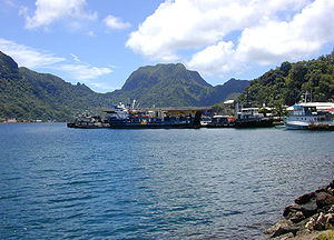
List of National Natural Landmarks in American Samoa
Encyclopedia
This is a list of National Natural Landmark
s (NNL) in American Samoa
.
National Natural Landmark
The National Natural Landmark program recognizes and encourages the conservation of outstanding examples of the natural history of the United States. It is the only natural areas program of national scope that identifies and recognizes the best examples of biological and geological features in...
s (NNL) in American Samoa
American Samoa
American Samoa is an unincorporated territory of the United States located in the South Pacific Ocean, southeast of the sovereign state of Samoa...
.
| Name | Designated | District Administrative divisions of American Samoa American Samoa is administratively divided into three districts and two "unorganized" atolls.The districts and unorganized atolls are subdivided into 16 counties and 74 villages.- Districts and counties :* Eastern District**Ituau County**Ma'Oputasi County... |
Coordinates | Description | Image |
|---|---|---|---|---|---|
| Cape Taputapu | 1972 | Western Western District, American Samoa The Western District is one of the primary divisions of American Samoa. It consists of the western portion of Tutuila Island. It has a land area of 74.781 km² and contains 29 villages plus a part of Nu'uuli village. Among these is the largest village of American Samoa, Tafuna, at its eastern end... |
14.3214°N 170.8432°W | A natural exhibit of shoreline, offshore volcanic rocks, and blowholes sculptured by heavy sea wave action | |
| Fogama'a Crater | 1972 | Western Western District, American Samoa The Western District is one of the primary divisions of American Samoa. It consists of the western portion of Tutuila Island. It has a land area of 74.781 km² and contains 29 villages plus a part of Nu'uuli village. Among these is the largest village of American Samoa, Tafuna, at its eastern end... |
14.3568°N 170.7535°W | One of very few illustrations of the most recent episode of volcanism in American Samoa | |
| Matafao Peak | 1972 | Eastern Eastern District, American Samoa The Eastern District is one of the primary divisions of American Samoa. It consists of the eastern portion of Tutuila, American Samoa's largest island, plus the island of Aunu'u. The district has a land area of 67.027 km² and a 2000 census population of 23,441. It contains 34 villages plus a... |
14.2939°N 170.7045°W | One of five great masses of volcanic rocks that extruded as molten magma during the major episodes of volcanism that created Tutuila Island | |
| Le'ala Shoreline | 1972 | Western Western District, American Samoa The Western District is one of the primary divisions of American Samoa. It consists of the western portion of Tutuila Island. It has a land area of 74.781 km² and contains 29 villages plus a part of Nu'uuli village. Among these is the largest village of American Samoa, Tafuna, at its eastern end... |
14.3600°N 170.7773°W | A young flow of basalt, inter-bedded with layers of tuff, that illustrates erosion by wave action | |
| Rainmaker Mountain (Mount Pioa) Rainmaker Mountain Rainmaker Mountain is the name of a mountain located near Pago Pago, American Samoa on Tutuila Island. The mountain is a volcanic feature known as a trachyte plug... |
1972 | Eastern Eastern District, American Samoa The Eastern District is one of the primary divisions of American Samoa. It consists of the eastern portion of Tutuila, American Samoa's largest island, plus the island of Aunu'u. The district has a land area of 67.027 km² and a 2000 census population of 23,441. It contains 34 villages plus a... |
14.2725°N 170.6558°W | An outstanding example of gigantic plugs that created Tutuila Island |  |
| Vai'ava Strait Vai'ava Strait Vai'ava Strait is the name of a little known strait located in American Samoa. Although little known, the strait is a National Natural Landmark. It is a great example of cliffs formed by waves on volcanic rock. The strait consists of communal lands. It was designated as a NNL in 1972.... |
1972 | Eastern Eastern District, American Samoa The Eastern District is one of the primary divisions of American Samoa. It consists of the eastern portion of Tutuila, American Samoa's largest island, plus the island of Aunu'u. The district has a land area of 67.027 km² and a 2000 census population of 23,441. It contains 34 villages plus a... |
14.2393°N 170.6715°W | A classic illustration of steep cliffs and erosion-resistant outliers formed by wave action on a volcanic mass | |
| Aunu'u Island Aunu'u Aunu'u is a small volcanic island off the southeastern shore of Tutuila in American Samoa. It has a land area of and a 2000 census population of 476 persons. Politically it is a part of the Eastern District, one of the primary divisions of American Samoa.... |
1972 | Eastern Eastern District, American Samoa The Eastern District is one of the primary divisions of American Samoa. It consists of the eastern portion of Tutuila, American Samoa's largest island, plus the island of Aunu'u. The district has a land area of 67.027 km² and a 2000 census population of 23,441. It contains 34 villages plus a... |
14.2833°N 170.5534°W | The site of recent episodes of volcanism backed by a geologically recent tuff cone | |

