
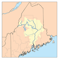
List of Maine rivers
Encyclopedia
List of river
s in Maine
(U.S. state
).
The list is organized by tributary structure, from north to south along the coast.
River
A river is a natural watercourse, usually freshwater, flowing towards an ocean, a lake, a sea, or another river. In a few cases, a river simply flows into the ground or dries up completely before reaching another body of water. Small rivers may also be called by several other names, including...
s in Maine
Maine
Maine is a state in the New England region of the northeastern United States, bordered by the Atlantic Ocean to the east and south, New Hampshire to the west, and the Canadian provinces of Quebec to the northwest and New Brunswick to the northeast. Maine is both the northernmost and easternmost...
(U.S. state
U.S. state
A U.S. state is any one of the 50 federated states of the United States of America that share sovereignty with the federal government. Because of this shared sovereignty, an American is a citizen both of the federal entity and of his or her state of domicile. Four states use the official title of...
).
The list is organized by tributary structure, from north to south along the coast.
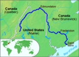
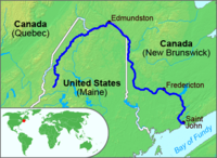
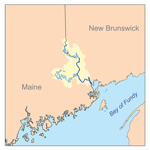
Saint John River
- Saint John River
- Northwest Branch Saint John RiverNorthwest Branch Saint John RiverThe Northwest Branch Saint John River is a river primarily in Aroostook County, Maine. Its origin is Lac Frontière in Quebec, Canada. After crossing the Canada – United States border, the Northwest Branch runs south close to the border until it picks up its tributary, the Daaquam River,...
- Daaquam RiverDaaquam RiverThe Daaquam River is a river primarily in Chaudière-Appalaches, Quebec.It runs from its source , south of Sainte-Justine, northeast across the Canada – United States border to the Northwest Branch of the Saint John River.-References:**...
- Daaquam River
- Southwest Branch Saint John RiverSouthwest Branch Saint John RiverThe Southwest Branch Saint John River is a river in Maine and Quebec. The branch originates in Little Saint John Lake on the international boundary between Saint-Zacharie, Quebec and Maine Township 5, Range 20, WELS...
- Little Southwest Branch Saint John RiverLittle Southwest Branch Saint John RiverThe Little Southwest Branch Saint John River is a river in Somerset County, Maine. From its source in Maine Township 6, Range 19, WELS, it flows northward a few miles east of the Canada – United States border to its mouth on the Southwest Branch Saint John River in T 9,...
- Baker Branch Saint John RiverBaker Branch Saint John RiverThe Baker Branch Saint John River is a river in Maine. The Baker Stream originates in Upper First Saint John Pond northeast of Truesdale Mountain in the northwest corner of Maine Township 4, Range 17, WELS...
- Little Southwest Branch Saint John River
- Big Black River
- Shields BranchShields BranchThe Shields Branch is a river in Quebec and Maine.From its source , in L'Islet RCM, the river runs south and southeast across the Canada – United States border in Maine Township 15, Range 15, WELS, to the Big Black River in T 14, R 15.-References:**...
- Little Saint Roch RiverLittle Saint Roch RiverThe Little Saint Roch River is a river in Quebec and Maine.From its source , in L'Islet RCM, the river runs south and southeast across the Canada – United States border to the Shields Branch of the Big Black River in Maine Township 15, Range 15, WELS.-References:**...
- Little Saint Roch River
- Shields Branch
- Little Black River
- West Branch Little Black River
- Campbell Branch Little Black RiverCampbell Branch Little Black RiverThe Campbell Branch Little Black River is a short river in Quebec and northern Maine.From its source , in Kamouraska RCM, Quebec, the river runs about 1 miles south to the Canada – United States border in Maine Township 18, Range 13, WELS....
- Allagash RiverAllagash RiverThe Allagash River is a tributary of the St. John River, approximately long, in northern Maine in the United States. It drains a remote and scenic area of wilderness in the Maine North Woods north of Mount Katahdin...
- St. Francis RiverSt. Francis River (Maine)The St. Francis River is a river roughly long, which forms part of the Canada – United States border. The river rises in a lake of the same name located east of the Rivière du Loup in Quebec...
- Fish RiverFish River (Maine)The Fish River is a river in northern Maine in the United States. It is a tributary of the St. John River, which flows to the Bay of Fundy in New Brunswick, Canada....
- Red RiverRed River (Maine)The Red River is a river in Maine. From the outflow of Fish Pond in Maine Township 15, Range 9, WELS, the river runs about southeast to Red River Falls in T.14 R.8 WELS, falling about . It runs then about northeast to St. Froid Lake in Winterville Plantation falling about . The...
- Birch RiverBirch River (Maine)The Birch River is a river in Aroostook County, Maine, in the United States. From the confluence of its North Branch and South Branch in the southwest corner of the town of Eagle Lake, the river runs southeast to St. Froid Lake in Winterville Plantation. The lake is drained by the Fish...
- North Branch Birch RiverNorth Branch Birch RiverThe North Branch Birch River is a river in Aroostook County, Maine, in the United States. From the outlet of a small pond in Maine Township 16, Range 8, WELS, it runs about east and about south to its confluence with the South Branch in the town of Eagle Lake to form the Birch River....
- South Branch Birch RiverSouth Branch Birch RiverThe South Branch Birch River is a river in Aroostook County, Maine, in the United States. From the outlet of a small pond in Maine Township 16, Range 9, WELS, it runs southeast and east to its confluence with the North Branch in the town of Eagle Lake to form the Birch River. It is part...
- North Branch Birch River
- Little RiverLittle River (Fish River)The Little River is a short river in Madawaska, Maine, about from the Canada – United States border.The river flows west from its source to Long Lake. The lake drains — via Mud Lake, Cross Lake, Square Lake, and Eagle Lake — into the Fish River, a tributary of the Saint John River.-References:**...
- Red River
- Aroostook RiverAroostook RiverThe Aroostook River is a tributary of the Saint John River in the U.S. state of Maine and the Canadian province of New Brunswick. Its basin is the largest sub-drainage of the St. John River....
- St. Croix StreamSt. Croix StreamSt. Croix Stream is an river in Aroostook County, Maine. From the outflow of St. Croix Lake in St. Croix Township , the river runs northwest to the Aroostook River in Masardis. Via the Aroostook River, St. Croix Stream is part of the St. John River watershed.-References:**...
- Blackwater RiverBlackwater River (Maine)The Blackwater River is a river in Aroostook County, Maine. From the confluence of its North Branch and South Branch in Squa Pan Township , the river runs west to St. Croix Stream in Masardis. Via St. Croix Stream and the Aroostook River, the Blackwater River is part of the St. John River...
- North Branch Blackwater RiverNorth Branch Blackwater River (Maine)The North Branch Blackwater River is a river in Squa Pan Township , Aroostook County, Maine. From its source , the stream runs west to its confluence with the South Branch to form the Blackwater River. Via the Blackwater River, St. Croix Stream, and the Aroostook River, the North Branch is...
- South Branch Blackwater RiverSouth Branch Blackwater River (Maine)The South Branch Blackwater River is an river in Aroostook County, Maine. From its source in Maine Township 9, Range 3, WELS, the stream runs northwest to its confluence with the North Branch to form the Blackwater River in Squa Pan Township . Via the Blackwater River, St...
- North Branch Blackwater River
- Blackwater River
- Machias RiverMachias River (Aroostook River)The Machias River is a major tributary of the Aroostook River, flowing through Aroostook County in the northern part of the state of Maine, USA. From the outflow of Big Machias Lake in Maine Township 12, Range 8, WELS, the river runs southeast and east to its confluence with the...
- South Branch Machias RiverSouth Branch Machias RiverThe South Branch Machias River is a river in Aroostook County, Maine. From the outflow of Center Pond in Maine Township 10, Range 8, WELS, the river runs east to its confluence with the Machias River in T.10 R.7 WELS. Via the Machias and Aroostook rivers, it is part of the St. John...
- South Branch Machias River
- Little Machias RiverLittle Machias RiverThe Little Machias River is a river in Maine. From its source in Maine Township 12, Range 7, WELS, it runs about east to Little Machias Lake and about southeast to its confluence with the Aroostook River in Ashland, downstream of the confluence of the Machias River with the...
- Little Madawaska River
- St. Croix Stream
- River De ChuteRiver De ChuteThe River De Chute is a river in Maine and New Brunswick.From the outflow of Lindsay Lake in Easton, Maine, the river runs about south, about half a mile west of the Canada – United States border....
- Meduxnekeag RiverMeduxnekeag RiverThe Meduxnekeag River is a small river in northern Maine in the United States and western New Brunswick, Canada. It is long.It rises from the outflow of Meduxnekeag Lake in New Limerick, Maine, and flows to its end in the Town of Woodstock, New Brunswick.The North and South branches rise in...
- South Branch Meduxnekeag RiverSouth Branch Meduxnekeag RiverThe South Branch Meduxnekeag River is a river in Aroostook County, Maine. From the outflow of Johnson Pond in Linneus, the river runs about southeast to Cary Plantation, then north about to its confluence with the Meduxnekeag River at Carys Mills, two miles upstream from Houlton.-References:**...
- North Branch Meduxnekeag RiverNorth Branch Meduxnekeag RiverThe North Branch Meduxnekeag River is a river in Aroostook County, Maine and Carleton County, New Brunswick.From the outlet of a small pond in Maine Township 8, Range 3, WELS, the river runs about northeast, south, and east to the Canada – United States border, crossing into Canada at...
- South Branch Meduxnekeag River
- Northwest Branch Saint John River
Down East
- St. Croix RiverSt. Croix River (Maine-New Brunswick)The St. Croix River is a river in northeastern North America, in length, that forms part of the Canada – United States border between Maine and New Brunswick . The river rises in the Chiputneticook Lakes and flows south and southeast, between Calais and St. Stephen...
- Little River (Big Lake)Little River (Big Lake)The Little River is a short river in Maine.From the outflow of Little River Lake in T.47 MD BPP, the river runs southeast and northeast to Big Lake in T.27 ED BPP....
- Little River (Big Lake)
- Little River (Passamaquoddy Bay)Little River (Passamaquoddy Bay)The Little River is a short, mostly-tidal river in Perry, Maine. From Boyden Stream Reservoir it runs about east to Passamaquoddy Bay.-References:**...
- Pennamaquan RiverPennamaquan RiverThe Pennamaquan River is a short, river in the U.S. state of Maine, draining from medium-sized, low-elevation Pennamaquan Lake into Cobscook Bay.- Course :The river begins at the outlet of Pennamaquan Lake, which is located about northwest of Pembroke...
- Hardscrabble RiverHardscrabble RiverHardscrabble River is the estuary of Wilson Stream, a small river in Washington County, Maine.From its source in Charlotte, Wilson Stream runs about southeast to Dennys Bay....
- Dennys RiverDennys RiverThe Dennys River is a river in Washington County, Maine. From the outflow of Meddybemps Lake in Meddybemps, the river runs about southeast and east to Dennysville, where it becomes tidal and soon joins the Hardscrabble River estuary to form Dennys Bay....
- Orange RiverOrange River (Maine)The Orange River is a short river in Whiting, Maine.From the outflow of Orange Lake , the river runs northeast to Whiting Bay.-References:**...
- Machias RiverMachias RiverThe Machias River is a river in Maine, USA. It flows through Washington County in the eastern part of the state, from Third Machias Lake , passing the town of Machias and emptying into Machias Bay.-History:...
- West Branch Machias RiverWest Branch Machias RiverThe West Branch Machias River is a tributary of the Machias River in Maine. The river starts from Sabao Dam on the Lower Pond of Lower Sabao Lake.-References:**...
- Crooked RiverCrooked River (Machias River)The Crooked River is an river in Maine Township 30 MD, BPP, Maine. From its source , the river runs about southeast, then winds generally northward to its confluence with the Machias River.-References:**...
- Middle RiverMiddle River (Maine)The Middle River is a short river in Washington County, Maine. From the outlet of Marks Lake in Marshfield, it runs about southeast to the estuary of the Machias River in Machias.-References:**...
- East Machias RiverEast Machias RiverThe East Machias River is a river in Washington County, Maine. From the outlet of Crawford Lake in Crawford, it runs southeast to the estuary of the Machias River at the head of Machias Bay. The river mouth is on the border between the towns of East Machias and Machiasport.-References:**...
- Maine RiverMaine River (Maine)The Maine River is a short river in Washington County, Maine. From the outlet of Pocomoonshine Lake in Princeton, it runs southwest to Crawford Lake in Plantation No. 21. The outlet of Crawford Lake is the East Machias River, flowing to Machias Bay....
- Maine River
- West Branch Machias River
- Englishman RiverEnglishman River (Maine)The Englishman River is a short river in Washington County, Maine. From its source , in Whitneyville, Maine, the river runs about south to Roque Bluffs, where it empties into Englishman Bay.-References:**...
- Chandler RiverChandler River (Maine)The Chandler River is a river in Washington County, Maine. It flows from its source on Cottontail Hill in Centerville to Jonesboro, where it empties into Englishman Bay.-References:**...
- East Branch Chandler RiverEast Branch Chandler RiverThe East Branch Chandler River is a tributary of the Chandler River in Washington County, Maine. It flows west from its source in Jonesboro, to its mouth in Centerville.-References:**...
- East Branch Chandler River
- Sandy RiverSandy River (Chandler Bay)The Sandy River is a very short river in Jonesport, Maine.From its source , the river runs about 1 mile southeast to the coast of Chandler Bay.-References:**...
- Indian RiverIndian River (Maine)The Indian River is a river in Washington County, Maine. From its source in Columbia Falls, the river runs about south to its estuary at the village of Indian River in the town of Addison. The tidal portion of the Indian River extends another south and then west to Wohoa Bay, an arm of Western...
- Southwest Branch Indian RiverSouthwest Branch Indian RiverThe Southwest Branch Indian River is a short stream in Addison, Maine. From its source , the river runs about east to its confluence with the Indian River.-References:**...
- Southwest Branch Indian River
- West RiverWest River (Maine)The West River is a short river in Addison, Maine. From its source , the river runs about to its confluence with the Indian River at the head of Wohoa Bay.-References:**...
- Pleasant RiverPleasant River (Pleasant Bay)The Pleasant River is a river in Washington County, Maine. From the outflow of Pleasant River Lake in Beddington, the river runs south, east, and south to Pleasant Bay. The river's mouth is on the border between the towns of Harrington and Addison....
- Western Little RiverWestern Little RiverThe Western Little River, or the Northwest Branch, is a tributary of the Pleasant River in Washington County, Maine. From its source in Maine Township 18, MD, BPP, the river runs southeast and south to its confluence with the Pleasant River, at Little River Corner in Columbia.-References:**...
- Little RiverLittle River (Pleasant River)The Little River is a tributary of the Pleasant River in Columbia Falls, Maine.From its source , the river runs south to its confluence with the Pleasant River.-References:**...
- West Branch Pleasant RiverWest Branch Pleasant River (Addison, Maine)The West Branch Pleasant River is a tributary of the Pleasant River in Washington County, Maine. From the confluence of Branch Brook and Bells Brook in southeast Columbia, the river meanders south to the estuary of the Pleasant River at Addison.-References:...
- Western Little River
- Harrington RiverHarrington RiverThe Harrington River is a river in Washington County, Maine. It empties into Harrington Bay in Harrington, Maine.-References:**...
- Mill RiverMill River (Harrington Bay)The Mill River is a short river in Washington County, Maine. From its source in Cherryfield, the river runs southeast to Flat Bay and its confluence with the Harrington River. Its lower length forms the border between the towns of Milbridge and Harrington....
- Narraguagus RiverNarraguagus RiverThe Narraguagus River is a river located in the U.S. state of Maine with its mouth in the Narraguagus Bay of the Gulf of Maine. It flows through the town of Cherryfield and was formerly well known for its sport fly fishing for Atlantic salmon. This was a traditional highlight of late spring with...
- West Branch Narraguagus River (Hancock County, Maine)West Branch Narraguagus River (Hancock County, Maine)The West Branch Narraguagus River is a short stream in Township 34, MD, Hancock County, Maine.From its source , the river runs east and southeast to its confluence with the Narraguagus River.-See also:* List of rivers of Maine...
- Little Narraguagus RiverLittle Narraguagus RiverThe Little Narraguagus River is a short stream in Maine. From the outflow of Bear Pond in Maine Township 28, MD, Hancock County, the river runs southeast and east to its confluence with the Narraguagus River in Beddington, Washington County....
- West Branch Narraguagus River (Cherryfield, Maine)West Branch Narraguagus River (Cherryfield, Maine)The West Branch Narraguagus River is a river in Maine. From its source in Maine Township 22, MD, Hancock County, the river runs southeast to its confluence with the Narraguagus River in Cherryfield, Washington County.-See also:...
- Spring RiverSpring River (Maine)The Spring River is a short stream in Township 16, MD, Hancock County, Maine. From the outflow of Narraguagus Lake , the river runs northeast to its confluence with the West Branch Narraguagus River.-References:**...
- Spring River
- West Branch Narraguagus River (Hancock County, Maine)
- Skillings RiverSkillings RiverThe Skillings River is a tidal river in Hancock County, Maine, flowing to Frenchman Bay. For most of its length it forms the boundary between the towns of Hancock and Lamoine.-References:***...
- Jordan RiverJordan River (Maine)The Jordan River is a tidal river in Hancock County, Maine, flowing to Mount Desert Narrows, the waterway that separates Mount Desert Island from the mainland. The Jordan River forms the boundary between the towns of Lamoine and Trenton.-References:***...
- Union RiverUnion River (Maine)The Union River is a river that runs through Ellsworth, Maine. In the colonial era, it was known as the Mount Desert River.The river forms at the north end of Graham Lake at the confluence of the river's East and West branches , on the border of the towns of Mariaville and Waltham...
- East Branch Union RiverEast Branch Union RiverThe East Branch Union River is a river in Hancock County, Maine. From the outflow of Rocky Pond in Maine Township 22 M D, the river runs southwest to Spectacle Pond in Osborn. From the pond's outlet, the river runs northwest, southwest, west and southwest to Graham Lake, where it joins the...
- Bog RiverBog River (Maine)The Bog River is a river in Hancock County, Maine. From its source on Sugar Hill in Maine Township 16 M D, the river runs northwest to its confluence with the East Branch of the Union River in Osborn.-References:**...
- Middle Branch Union RiverMiddle Branch Union RiverThe Middle Branch Union River is a river in Hancock County, Maine. From the outflow of Lower Middle Branch Pond in Aurora, the river runs west and south to its confluence with the East Branch of the Union River in Osborn.-References:**...
- Bog River
- West Branch Union RiverWest Branch Union RiverThe West Branch Union River is a river in Hancock County, Maine. From the outflow of Great Pond in the town of Great Pond , the river runs southwest and south to Graham Lake, where it joins the East Branch in Mariaville to form the Union River.-References:**...
- Webb Brook
- Webb Pond
- Mill Brook
- Little Bog RiverLittle Bog RiverThe Little Bog River is a short stream in Hancock County, Maine. From its source in Osborn, the river runs south to its confluence with Mill Brook in Eastbrook. Mill Brook flows west to Webb Pond. Via Mill Brook, Webb Pond, and Webb Brook, the Little Bog River is part of the Union River...
- Little Bog River
- Mill Brook
- Webb Pond
- East Branch Union River
- Benjamin RiverBenjamin RiverThe Benjamin River is a tidal river in Hancock County, Maine.From its source , the river runs about 3 miles southwest to Eggemoggin Reach.The river forms part of the border between Sedgwick and Brooklin.-References:**...
Penobscot Bay
- Bagaduce RiverBagaduce RiverThe Bagaduce River is a tidal river in the Hancock County, Maine that empties into Penobscot Bay near the town of Castine. From the confluence of Black Brook and the outflow of Walker Pond , the river runs about north, northwest, and southwest, forming the border between Brooksville on its left...
- Penobscot RiverPenobscot RiverThe Penobscot River is a river in the U.S. state of Maine. Including the river's West Branch and South Branch increases the Penobscot's length to , making it the second longest river system in Maine and the longest entirely in the state. Its drainage basin contains .It arises from four branches...
- East Branch Penobscot RiverEast Branch Penobscot RiverThe East Branch Penobscot River is a tributary of Maine's Penobscot River. From its source in Maine Township 7, Range 11, WELS, in Piscataquis County, the river runs southeast to Grand Lake Matagamon in the northeast corner of Baxter State Park...
- Seboeis RiverSeboeis RiverThe Seboeis River is a river in Penobscot County, Maine. The river is the outflow of Snowshoe Lake in Maine Township 7, Range 7, WELS; Snowshoe Lake is fed via a short stream from Grand Lake Seboeis...
- Little Seboeis RiverLittle Seboeis RiverThe Little Seboeis River is a short stream in Maine Township 4, Range 7, WELS, Penobscot County, Maine. From its source , the river runs south and west to its confluence with the Seboeis River.-References:**...
- Little Seboeis River
- Seboeis River
- West Branch Penobscot RiverWest Branch Penobscot RiverThe West Branch Penobscot River is a tributary of Maine's Penobscot River. The river flows from Seboomook Lake in Seboomook, Somerset County; the lake's principal inflows are the North Branch and South Branch Penobscot River...
- North Branch Penobscot RiverNorth Branch Penobscot RiverThe North Branch Penobscot River is a river in Somerset County, Maine. From its source at the outlet of Little Bog about east of the Canada – United States border in Maine Township 6, Range 17, WELS, the river runs southwest and southeast to its drowned confluence with the South Branch...
- South Branch Penobscot RiverSouth Branch Penobscot RiverThe South Branch Penobscot River is a river in Somerset County, Maine. Its source, an unnamed lake, the north end of which at is about from the Canada – United States border in Sandy Bay...
- North Branch Penobscot River
- Mattawamkeag RiverMattawamkeag RiverThe Mattawamkeag River is a river in Maine. From the confluence of its East Branch and West Branch in Haynesville, about west of the Canada – United States border, the river runs south and west to its mouth on the Penobscot River in Mattawamkeag....
- East Branch Mattawamkeag RiverEast Branch Mattawamkeag RiverThe East Branch Mattawamkeag River is a tributary of the Mattawamkeag River in Aroostook County, Maine. From its source in Dudley , the river runs south and southeast to its confluence with the West Branch Mattawamkeag River in Haynesville, about west of the Canada – United States...
- West Branch Mattawamkeag RiverWest Branch Mattawamkeag RiverThe West Branch Mattawamkeag River is a tributary of the Mattawamkeag River in Maine. From its source in Maine Township 6, Range 6, WELS, the river runs northeast by Pleasant Lake and through Mud Lake and Rockabema Lake, then south and southeast through Upper Mattawamkeag Lake and...
- Molunkus StreamMolunkus StreamMolunkus Stream is a tributary of the Mattawamkeag River in Maine. From the confluence of the stream's East Branch and West Branch in Sherman, the river runs southeast to its mouth on the Mattawamkeag in Kingman.-References:**...
- East Branch Mattawamkeag River
- Piscataquis RiverPiscataquis RiverThe Piscataquis River is a major tributary of the Penobscot River, found in Piscataquis County, Maine, United States. It starts from the confluence of its East Branch and West Branch in Blanchard. The river flows in a mostly eastern direction until it meets the Penobscot at Howland...
- East Branch Piscataquis RiverEast Branch Piscataquis RiverThe East Branch Piscataquis River is a tributary of the Piscataquis River in Piscataquis County, Maine. From its source in Little Squaw , it runs south to its confluence with the West Branch Piscataquis River in Blanchard to form the Piscataquis.The Appalachian Trail crosses the East Branch just...
- West Branch Piscataquis RiverWest Branch Piscataquis RiverThe West Branch Piscataquis River is a tributary of the Piscataquis River in Piscataquis County, Maine. Its source is in East Moxie, Somerset County ....
- Sebec RiverSebec RiverThe Sebec River is a tributary of the Piscataquis River in Piscataquis County, Maine. From the outflow of Sebec Lake in Sebec, the river runs east and southeast to its confluence with the Piscataquis in Milo.-References:**...
- Pleasant RiverPleasant River (Piscataquis River)The Pleasant River is a tributary of the Piscataquis River in Piscataquis County, Maine. From the confluence of the East Branch and West Branch in Brownville, the river runs south and southeast to its mouth on the Piscataquis in Medford.-References:**...
- East Branch Pleasant RiverEast Branch Pleasant River (Piscataquis River)The East Branch Pleasant River is a tributary of the Piscataquis River in Piscataquis County, Maine. From its source in Shawtown , the river runs about generally southeast to Upper Ebeemee Lake, then about south through Ebeemee Lake to its confluence with the West Branch to form the Pleasant...
- Middle Branch Pleasant RiverMiddle Branch Pleasant RiverThe Middle Branch Pleasant River is a tributary of the Piscataquis River in Piscataquis County, Maine. From the outflow of Middle Branch Pond in Maine Township 5, Range 9, WELS, the river runs southeast to its confluence with the East Branch in Brownville...
- Middle Branch Pleasant River
- West Branch Pleasant RiverWest Branch Pleasant River (Piscataquis River)The West Branch Pleasant River is a tributary of the Piscataquis River in Piscataquis County, Maine. From a location north of Fourth West Branch Pond in Shawtown , the river runs about counterclockwise around the White Cap Mountain massif, then about southeast to its confluence with the East...
- East Branch Pleasant River
- East Branch Piscataquis River
- Passadumkeag RiverPassadumkeag RiverThe Passadumkeag River is a river in Maine.From the confluence of its East Branch and West Branch in Maine Township 3, Range 1, NBPP, the river runs south and west to its mouth on the Penobscot River in Passadumkeag.- East Branch :...
- East Branch Passadumkeag River
- West Branch Passadumkeag River
- Stillwater RiverStillwater River (Maine)The Stillwater River is an side channel of the Penobscot River in Maine. From its source in Old Town, the Stillwater runs northwest along the northeast side of Orson Island, the site of the Penobscot Indian Reservation. It then runs south along the west sides of Orson and Marsh islands, over...
- Kenduskeag StreamKenduskeag StreamKenduskeag Stream is a stream in the U.S. state of Maine. It is a tributary of the Penobscot River. The stream rises at the outlet of Garland Pond in the town of Garland, and flows southeast through Corinth, Kenduskeag, and Glenburn, before entering the city of Bangor...
- North Branch Marsh RiverNorth Branch Marsh RiverThe North Branch Marsh River is a tidal river in the town of Frankfort, Waldo County, Maine. It is a tributary of Marsh Bay, an arm of the tidal Penobscot River....
- Marsh Stream
- South Branch Marsh RiverSouth Branch Marsh RiverThe South Branch Marsh River is a tidal river in the towns of Prospect and Frankfort in Waldo County, Maine. It joins the North Branch Marsh River to form Marsh Bay, a short arm of the tidal Penobscot River....
- Orland RiverOrland RiverThe Orland River is a river in the town of Orland in Hancock County, Maine. It is part of the Penobscot River watershed.The Orland River is primarily tidal and is known upstream from tidewater as the Narramissic River...
- Narramissic RiverNarramissic RiverThe Narramissic River is a river in Hancock County, Maine. It is the upstream freshwater section of the tidal Orland River, a tributary of the Penobscot River....
- Dead RiverDead River (Narramissic River)The Dead River is a arm of Alamoosook Lake in the town of Orland in Hancock County, Maine. Via Alamoosook Lake, the Narramissic River, and the Orland River, it is part of the Penobscot River watershed. It is formed by the junction of Moosehorn Stream and Hothole Stream and extends south to the...
- Dead River
- Narramissic River
- East Branch Penobscot River
- Goose River (Belfast Bay)
- Passagassawakeag RiverPassagassawakeag RiverThe Passagassawakeag River is a river in Waldo County, Maine in the United States. From the outlet of Lake Passagassawakeag in Brooks, it runs south and east to its estuary in Belfast, Maine...
- Little RiverLittle River (Penobscot Bay)The Little River is a short river in Waldo County, Maine. From its source in Belmont, the river runs east to Belfast Bay, on the border between Belfast and Northport.-References:**...
- Ducktrap RiverDucktrap RiverThe Ducktrap River is a river in Waldo County, Maine. From the outflow in Tilden Pond in Belmont, the river runs southeast, through Camden Hills State Park, to West Penobscot Bay in Lincolnville.-References:**...
- Megunticook RiverMegunticook RiverThe Megunticook River is a short river in Camden, Maine. From the spillway of Megunticook Lake , the river runs southeast through the town to West Penobscot Bay.-References:**...
- Goose River (Rockport Harbor)Goose River (Rockport Harbor)The Goose River is a river in Knox County, Maine. From the outflow of Hosmer Pond in Camden, the river runs southeast to Rockport Harbor, in Rockport.-References:**...
Mid Coast
- Weskeag RiverWeskeag RiverThe Weskeag River is a short tidal river in Knox County, Maine. The Abenaki Indians called it Wessaweskeag, meaning "tidal creek" or "salt creek". From its source in South Thomaston, the river runs northeast and southeast to its confluence with Marsh Creek, then southeast through its estuary to...
- Saint George RiverSaint George RiverThe Saint George River is a river in Maine with a watershed of in a unique and historic area of mountains, sea coast, lakes, tidal streams and inlets. The origin of the Saint George River is the outflow of Saint George Lake in Liberty...
- Dead RiverDead River (Saint George River)The Dead River is a tributary of the Saint George River in the U.S. state of Maine. From the outflow of Newbert Pond in Appleton, the stream runs northeast to its confluence with the Saint George River in Searsmont.-References:**...
- Back River (Saint George River)Back River (Saint George River)The Back River is a tributary of the Saint George River in Knox County, Maine. From its source in Far Meadow in Cushing, the river runs north, through South and North Ponds, to its confluence with the Saint George in Warren.- References :* *...
- Oyster RiverOyster River (Maine)The Oyster River is a tributary of the Saint George River in Knox County, Maine. From its source in Rockport, the river runs south and southwest to its confluence with the Saint George. Its lower third forms the border between Warren and Thomaston....
- West Branch Oyster RiverWest Branch Oyster RiverThe West Branch Oyster River is a tributary of the Oyster River in Warren, Maine. From its source , the stream runs about 2 miles south and 1 mile east to its confluence with the main stem of the Oyster River.- References :* *...
- East Branch Oyster RiverEast Branch Oyster RiverThe East Branch Oyster River is a tributary of the Oyster River in Knox County, Maine.From its source in Rockland, the stream runs southwest to its confluence with the main stem of the Oyster River, on the border between Warren and Thomaston.- References :...
- West Branch Oyster River
- Mill River
- Dead River
- Meduncook RiverMeduncook RiverThe Meduncook River is a river in Knox County, Maine. From its source in Friendship, the river runs about 1 mile south to the head of its estuary, then about 6 miles southwest to Muscongus Bay....
- Back River (Meduncook River)Back River (Meduncook River)The Back River is a short tributary of the Meduncook River in Friendship, Maine. From its source , the river runs south to the estuary of the Meduncook.- References :* *...
- Back River (Meduncook River)
- Medomak RiverMedomak RiverThe Medomak River is a river in Maine. From its source in Liberty, the river winds south to the head of its estuary in Waldoboro, then about south to Bremen. The river flows through Hockomock Channel into the head of Muscongus Bay.-References:**...
- Back River (Medomak River)Back River (Medomak River)The Back River is a river in Friendship, Maine, which empties into the estuary of the Medomak River.- References :* *...
- Goose RiverGoose River (Medomak River)The Goose River is a tributary of the Medomak River in the U.S. state of Maine.-References:***...
- Back River (Medomak River)
- Pemaquid RiverPemaquid RiverThe Pemaquid River is a river in Bristol, Maine.From the outflow of Biscay Pond , the river runs south to the head of its estuary, then to Pemaquid Harbor at the head of Johns Bay.-References:**...
- Johns RiverJohns River (Maine)The Johns River is an extension of Johns Bay in Lincoln County, Maine.From Johns Island, it runs north, then splits into its Eastern Branch and North Branch, which run about a mile further north....
- Eastern Branch Johns River
- North Branch Johns River
- Damariscotta RiverDamariscotta RiverThe Damariscotta River is a tidal river in Lincoln County, Maine, that empties into the Atlantic Ocean. Damariscotta is an old Abenaki word for "river of many fishes"...
- Little River (Damariscotta River)Little River (Damariscotta River)The Little River is a stream and tidal river on Linekin Neck in the town of Boothbay in the U.S. state of Maine. It is a small tidal river for its lower , entering the Atlantic Ocean just west of the mouth of the Damariscotta River.-References:***...
- Little River (Damariscotta River)
- Sheepscot RiverSheepscot RiverThe Sheepscot River is a river in the U.S. state of Maine. Its lower portion is a complex island estuary with connections to the Kennebec River downstream of Merrymeeting Bay.-Route:...
- West Branch Sheepscot RiverWest Branch Sheepscot RiverThe West Branch Sheepscot River is a river in Maine. The branch originates in the northwest corner of Palermo and flows southwesterly through Branch Pond and the village of Weeks Mills in the town of China. The branch then flows southerly through the town of Windsor to a confluence with the...
- Dyer RiverDyer RiverThe Dyer River is a river in Maine. It originates along the northern boundary of the town of Jefferson with the town of Somerville and flows southwesterly through Jefferson, passing through Dyer Long Pond and near South Jefferson...
- Marsh RiverMarsh River (Maine)The Marsh River is a tidal river in Newcastle, Maine, in the United States. It is a tributary of the Sheepscot River.The Marsh River is formed at the confluence of Deer Meadow Brook and the outlet of Sherman Lake in the western corner of Newcastle and flows west, north, and west again to join the...
- Cross RiverCross River (Maine)The Cross River is a tidal river in Maine. It is a tributary of the Sheepscot River.The Cross River begins in the town of Boothbay and runs north. Turning west, it becomes the boundary between Boothbay and Edgecomb and continues to the Sheepscot River, at the three-way town boundary intersection...
- Back River (Boothbay, Maine)Back River (Boothbay, Maine)The Back River is a tidal channel in the town of Boothbay, Maine, in the United States. It defines the east and south sides of Barters Island and connects with the Sheepscot River, which forms the west side of the island. The Cross River joins the north end of the Back River with the Sheepscot...
- Sasanoa RiverSasanoa RiverThe Sasanoa River is an tidal channel in the Midcoast region of Maine, connecting the Kennebec River with the Sheepscot River.The Sasanoa River has two distinct sections. The western section begins at the Kennebec River opposite the city of Bath and runs east, forming the boundary between the...
(connects to Kennebec River) - Little Sheepscot River
- West Branch Sheepscot River
- Little River (Georgetown, Maine)Little River (Georgetown, Maine)The Little River is a river in the town of Georgetown, Maine. It flows directly into the Atlantic Ocean, between the mouth of the Sheepscot River to the east and the Kennebec River to the west. The lower portion of its course forms the western boundary of Reid State Park.-References:**...
Kennebec River
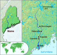
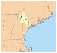
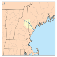
- Kennebec RiverKennebec RiverThe Kennebec River is a river that is entirely within the U.S. state of Maine. It rises in Moosehead Lake in west-central Maine. The East and West Outlets join at Indian Pond and the river then flows southward...
- Moose RiverMoose River (Maine)The Moose River is an river in Maine. Its source is in Beattie , on the Canada – United States border, which runs along the height of land between the watersheds of the Kennebec River in Maine and the Chaudière River in Quebec...
- South Branch Moose RiverSouth Branch Moose River (Maine)The South Branch Moose River is a tributary of the Moose River in Franklin County, Maine. Its source on Caribou Mountain is about from the Canada – United States border, in Skinner . From there, the river winds generally north for to its confluence with the main stream of the Moose River in...
- East Branch Moose RiverEast Branch Moose River (Maine)The East Branch Moose River is a short tributary of the South Branch Moose River in Skinner , Maine.From its source on Kibby Mountain, the river runs northwest to its confluence with the Moose River's South Branch....
- West Branch Moose RiverWest Branch Moose River (Maine)The West Branch Moose River is a short tributary of the South Branch Moose River in Franklin County, Maine. Its source is on Caribou Mountain in Merrill Strip , about from the Canada – United States border, which runs along the height of land between the watersheds of the Kennebec River in Maine...
- East Branch Moose River
- South Branch Moose River
- Roach RiverRoach River (Maine)The Roach River is a river in Piscataquis County, Maine. From the outlet of Third Roach Pond in Shawtown , the river runs west, through Second and First Roach Ponds. The Roach River empties into Moosehead Lake, the source of the Kennebec River, in Spencer Bay .-References:**...
- Dead River (also called West Branch)
- North Branch Dead RiverNorth Branch Dead RiverThe North Branch Dead River is a tributary of the Dead River in Franklin County, Maine. It is paralleled by Maine State Route 27.From the outflow of Lower Pond in Chain of Ponds , the river runs southeast to Eustis, where its confluence with the South Branch of the Dead River was drowned by the...
- South Branch Dead RiverSouth Branch Dead RiverThe South Branch Dead River is a tributary of the Dead River in Franklin County, Maine.From the outflow of Saddleback Lake below Saddleback Mountain, the river runs northeast to Eustis, where its confluence with the North Branch of the Dead River was drowned by the impoundment of Flagstaff Lake...
- North Branch Dead River
- Carrabassett RiverCarrabassett RiverThe Carrabassett River, a tributary of the Kennebec River, is located in Franklin County and Somerset County, Maine, in the United States. It rises near Sugarloaf Mountain, east of Rangeley Lake, and runs for , flowing southeast past Kingfield and joining the Kennebec River in the town of...
- South Branch Carrabassett River
- West Branch Carrabassett RiverWest Branch Carrabassett RiverThe West Branch Carrabassett River is a short tributary of the Carrabassett River in Franklin County, Maine. From the confluence of Quick Stream with a small stream in Salem, the river runs northeast to its mouth in Kingfield.-References:**...
- Sandy RiverSandy River (Kennebec River)The Sandy River is a tributary of the Kennebec River in the U.S. state of Maine.The Sandy River originates in the Sandy River Ponds at an elevation of in Sandy River Plantation. The river flows south to a confluence with Chandler Mill Stream in Maine Township E and then easterly to its...
- South Branch Sandy RiverSouth Branch Sandy RiverThe South Branch Sandy River is a short tributary of the Sandy River in Franklin County, Maine. From its source on Blueberry Mountain in Berlin , the river runs northeast to its confluence with the Sandy River in Phillips....
- Lemon Stream
- South Branch Sandy River
- Sebasticook RiverSebasticook RiverThe Sebasticook River is a river in the central part of Maine, in the United States. It flows from Great Moose Lake, about north of Winslow, Maine, to the Kennebec River in Winslow.According to the Sebasticook River Watershed Association:...
- East Branch Sebasticook RiverEast Branch Sebasticook RiverThe East Branch Sebasticook River is a tributary of the Sebasticook River in central Maine in the United States. It is part of the Kennebec River watershed.-References:**...
- East Branch Sebasticook River
- Little RiverLittle River (Kennebec River)The Little River is a tidal channel connecting at each end with the Kennebec River in the town of Perkins in the U.S. state of Maine. It passes to the west of Little Swan Island while the main stem of the Kennebec passes to the east.-References:**...
- Eastern RiverEastern RiverThe Eastern River is a tributary of the Kennebec River in Maine. It rises in East Pittston at the confluence of its west and east branches and flows southwest past Dresden Mills to its mouth at the Kennebec, at the town boundary between Dresden and Perkins....
- East Branch Eastern RiverEast Branch Eastern RiverThe East Branch Eastern River is a river in Maine. It is part of the Kennebec River watershed. It rises in the town of Whitefield and flows southwest to its confluence with the West Branch Eastern River at East Pittston to form the Eastern River.-References:...
- West Branch Eastern RiverWest Branch Eastern RiverThe West Branch Eastern River is a tributary of the Eastern River in Maine. It is part of the Kennebec River watershed. The West Branch begins near South Windsor and flows southwest through the town of Whitefield, joining the East Branch at East Pittston to form the Eastern River.-References:**...
- East Branch Eastern River
- Abagadasset RiverAbagadasset RiverThe Abagadasset River is a river in Richmond and Bowdoinham, Maine, flowing into Merrymeeting Bay, part of the estuary of the Kennebec River.-References:**...
- Androscoggin RiverAndroscoggin RiverThe Androscoggin River is a river in the U.S. states of Maine and New Hampshire, in northern New England. It is long and joins the Kennebec River at Merrymeeting Bay in Maine before its water empties into the Gulf of Maine on the Atlantic Ocean. Its drainage basin is in area...
- Rapid RiverRapid River (Maine)The Rapid River is a river in the northwestern portion of the US state of Maine flowing from Lower Richardson Lake to Umbagog Lake. Despite its short length, it forms the end of a major portion of the Umbagog Lake and Androscoggin River watersheds...
- Cupsuptic RiverCupsuptic RiverThe Cupsuptic River is a river in Maine. It flows from its source near the Canada – United States border to Cupsuptic Lake, the northern arm of Mooselookmeguntic Lake, which drains via other lakes into the Androscoggin River...
- East Branch Cupsuptic RiverEast Branch Cupsuptic RiverThe East Branch Cupsuptic River is a short tributary of the Cupsuptic River in Maine. It flows about from its source in a cirque between Snow Mountain and Twin Mountains, to its mouth on the Cupsuptic.-References:**...
- Little East Branch Cupsuptic RiverLittle East Branch Cupsuptic RiverThe Little East Branch Cupsuptic River is a short tributary of the Cupsuptic River in Maine. It flows from its source , on the slope of West Kennebago Mountain, to its mouth on the Cupsuptic.-References:**...
- East Branch Cupsuptic River
- Kennebago RiverKennebago RiverThe Kennebago River is a river in northwestern Maine. It is a tributary of Cupsuptic Lake, an arm of Mooselookmeguntic Lake. Via a chain of lakes and the Rapid River, it is part of the Androscoggin River watershed.-References:**...
- Rangeley RiverRangeley RiverThe Rangeley River is located in Franklin County, Maine, in the United States. It is only about a mile long, connecting the outlet of Rangeley Lake with Mooselookmeguntic Lake.It is part of the Androscoggin River watershed....
- Cupsuptic River
- Magalloway RiverMagalloway RiverThe Magalloway River is a river in northwestern Maine and northern New Hampshire in the United States. It is a tributary of the Androscoggin River, which flows to the Kennebec River at Merrymeeting Bay in Maine, near the Atlantic Ocean...
- West Branch Magalloway RiverWest Branch Magalloway RiverThe West Branch of the Magalloway River is a river in northernmost New Hampshire and northwestern Maine in the United States. It is a tributary of the Magalloway River, located in the Androscoggin River watershed of Maine and New Hampshire....
- Third East Branch Magalloway RiverThird East Branch Magalloway RiverThe Third East Branch Magalloway River is a stream in northwestern Maine. It is a tributary of the West Branch Magalloway River, which flows to the Magalloway River, then the Androscoggin River, and ultimately to the tidal Kennebec River and the Atlantic Ocean.-References:**...
- Third East Branch Magalloway River
- Second East Branch Magalloway RiverSecond East Branch Magalloway RiverThe Second East Branch Magalloway River is a river in northwestern Maine. It is a tributary of the Magalloway River, part of the Androscoggin River watershed.-References:**...
- First East Branch Magalloway RiverFirst East Branch Magalloway RiverThe First East Branch Magalloway River is a river in northwestern Maine. It is a tributary of the Magalloway River, which flows to the Androscoggin River and ultimately to the tidal Kennebec River and the Atlantic Ocean.-References:**...
- Little Magalloway RiverLittle Magalloway RiverThe Little Magalloway River is a river in northwestern Maine in the United States. It is a tributary of the Magalloway River, located in the Androscoggin River watershed of Maine and New Hampshire....
- Middle Branch Little Magalloway RiverMiddle Branch Little Magalloway RiverThe Middle Branch of the Little Magalloway River is a river in northern New Hampshire and northwestern Maine in the United States. It is a tributary of the West Branch of the Little Magalloway, located in the Androscoggin River watershed of Maine and New Hampshire.The river rises in Pittsburg,...
- West Branch Little Magalloway RiverWest Branch Little Magalloway RiverThe West Branch of the Little Magalloway River is a river in northern New Hampshire and northwestern Maine in the United States. It is a tributary of the Little Magalloway River, located in the Androscoggin River watershed of Maine and New Hampshire....
- Middle Branch Little Magalloway River
- West Branch Magalloway River
- Dead Cambridge RiverDead Cambridge RiverThe Dead Cambridge River is a river in northwestern Maine. It is a tributary of Lake Umbagog, the outflow of which is the Androscoggin River, flowing to the tidal Kennebec River and the Atlantic Ocean.-References:**...
- Swift Cambridge RiverSwift Cambridge RiverThe Swift Cambridge River is a river in northwestern Maine. It rises near the New Hampshire border, north of Grafton Notch, and flows north to the Dead Cambridge River, a tributary of Umbagog Lake. The Androscoggin River flows from Umbagog to the tidal Kennebec River in Maine.-References:**...
- Swift Cambridge River
- Wild RiverWild River (Androscoggin River)The Wild River is a river in the White Mountains of New Hampshire and Maine in the United States. It is a tributary of the Androscoggin River, which flows east and south to the Kennebec River near the Atlantic Ocean.-Route:...
- Pleasant RiverPleasant River (Androscoggin River)Pleasant River is a river in Oxford County, Maine in the United States. It is a tributary of the Androscoggin River, which flows east and south to join the Kennebec River in Merrymeeting Bay near the Atlantic Ocean....
- East Branch Pleasant RiverEast Branch Pleasant River (Androscoggin River)The East Branch Pleasant River is a tributary of the Pleasant River in the U.S. state of Maine. The Pleasant River is a tributary of the Androscoggin River, which flows southeast to the tidal Kennebec River and the Atlantic Ocean....
- West Branch Pleasant RiverWest Branch Pleasant River (Androscoggin River)The West Branch Pleasant River is a tributary of the Pleasant River in the U.S. state of Maine. It is part of the Androscoggin River watershed, which flows to the tidal Kennebec River near its mouth at the Atlantic Ocean....
- East Branch Pleasant River
- Alder RiverAlder RiverThe Alder River is a river in Maine. A tributary of the Androscoggin River, the Alder flows west from Locke Mills to Bethel.-References:**...
- Sunday RiverSunday River (Androscoggin River)Sunday River is a river in Oxford County, Maine in the United States. It is a tributary of the Androscoggin River, which flows east and south to join the Kennebec River in Merrymeeting Bay near the Atlantic Ocean....
- South Branch Sunday RiverSouth Branch Sunday RiverThe South Branch Sunday River is a mountain stream in western Maine. It is a tributary of the Sunday River, which flows to the Androscoggin River and ultimately to the Kennebec River and the Atlantic Ocean....
- South Branch Sunday River
- Bear RiverBear River (Androscoggin River)The Bear River is a tributary of the Androscoggin River in the U.S. state of Maine. It rises in Grafton Notch at the northeastern end of the Mahoosuc Range and flows southeast, joining the Androscoggin in the town of Newry. Maine Route 26 follows the entire course of the river.-References:**...
- Ellis RiverEllis River (Maine)The Ellis River is a river in Oxford County in western Maine. It is a tributary of the Androscoggin River.The river begins at the outlet of Ellis Pond in the northwest corner of Roxbury and flows southwest via a meandering course into Andover, passing the village of East Andover before turning...
- West Branch Ellis RiverWest Branch Ellis RiverThe West Branch Ellis River is a river in western Maine. It is a tributary of the Ellis River, which flows to the Androscoggin River and ultimately to the Kennebec River near its mouth at the Atlantic Ocean....
- West Branch Ellis River
- Concord RiverConcord River (Maine)The Concord River is a tributary of the Androscoggin River in western Maine. The Androscoggin flows east and southeast to the Kennebec River near its mouth at the Atlantic Ocean....
- Swift RiverSwift River (Maine)The Swift River is a river in western Maine. It is a tributary of the Androscoggin River, which flows to the Kennebec River near its mouth at the Atlantic Ocean....
- West Branch Swift RiverWest Branch Swift River (Maine)The West Branch Swift River is a tributary of the Swift River in western Maine. Via the Swift River, it is part of the Androscoggin River watershed, flowing to the Kennebec River and ultimately the Atlantic Ocean....
- East Branch Swift RiverEast Branch Swift River (Maine)The East Branch Swift River is a tributary of the Swift River in western Maine. Via the Swift River, it is part of the Androscoggin River watershed, which flows to the Kennebec River and ultimately the Atlantic Ocean.-References:**...
- West Branch Swift River
- Webb RiverWebb RiverThe Webb River is a river in western Maine. It is a tributary of the Androscoggin River, which flows to the Kennebec River and ultimately the Atlantic Ocean....
- Dead River (Androscoggin River)Dead River (Androscoggin River)The Dead River is a tributary of the Androscoggin River in western Maine in the United States. The river flows from , northwest through the town of Leeds to the Androscoggin. This is the outlet of a chain of ponds, of which Androscoggin Pond is the largest and last. The river has the rare power...
- Nezinscot RiverNezinscot RiverThe Nezinscot River is a river in Maine. It runs east from the confluence of its East Branch and West Branch in Buckfield to its mouth on the Androscoggin River in Turner.-References:**...
- East Branch Nezinscot RiverEast Branch Nezinscot RiverThe East Branch Nezinscot River is a river in Maine. It flows from its source on Black Mountain in Peru to its confluence with the West Branch in Buckfield. The resulting river, the Nezinscot, continues east to the Androscoggin River, which flows to the Kennebec River near its mouth at the...
- West Branch Nezinscot RiverWest Branch Nezinscot RiverThe West Branch Nezinscot River is an river in Maine. It flows from Shagg Pond in Woodstock to its confluence with the East Branch in Buckfield. The resulting river, the Nezinscot, flows east to the Androscoggin River, which in turn flows southeast to the Kennebec River near its mouth at the...
- East Branch Nezinscot River
- Little Androscoggin RiverLittle Androscoggin RiverThe Little Androscoggin River is a river in Maine. It flows from Bryant Pond in Woodstock to its confluence with the Androscoggin River in Auburn...
- Sanborn RiverSanborn RiverThe Sanborn River is a river in Maine. It flows from its source on Round Mountain in the unorganized territory of South Oxford to Hicks Pond in the town of Greenwood. Hicks Pond drains via Niles Brook into the Little Androscoggin River, the Androscoggin River, and thence into Merrymeeting Bay in...
- Sanborn River
- Sabattus RiverSabattus RiverThe Sabattus River is an tributary of the Androscoggin River in Maine. It rises at the outlet of Sabattus Pond in the town of Sabattus and flows south into the town of Lisbon, reaching the Androscoggin just southeast of Lisbon Center and about upstream of Lisbon Falls...
- Dead River (Sabattus River)Dead River (Sabattus River)The Dead River is a tributary of Sabattus Pond in the U.S. state of Maine. Via the Sabattus River, the outflow of the pond, the Dead River is part of the Androscoggin River watershed, flowing to the Kennebec River and ultimately the Atlantic Ocean....
- Dead River (Sabattus River)
- Little RiverLittle River (Androscoggin River)The Little River is a tributary of the Androscoggin River in the U.S. state of Maine. It forms the boundary between Sagadahoc and Androscoggin counties....
- Muddy RiverMuddy River (Merrymeeting Bay)The Muddy River is a river in Topsham, Maine, which empties into Merrymeeting Bay.-References:**...
- Cathance RiverCathance RiverThe Cathance River is a river in Maine flowing into Merrymeeting Bay.It rises in Bowdoin at the junction of West Cathance and East Cathance streams and flows south into Topsham. Turning east and then northeast, it reaches tidewater at the village of Cathance within Topsham and continues northeast...
- Rapid River
- Sasanoa RiverSasanoa RiverThe Sasanoa River is an tidal channel in the Midcoast region of Maine, connecting the Kennebec River with the Sheepscot River.The Sasanoa River has two distinct sections. The western section begins at the Kennebec River opposite the city of Bath and runs east, forming the boundary between the...
(connects to Sheepscot River) - Back River (Kennebec River)Back River (Kennebec River)The Back River is a waterway in coastal Maine, in the combined estuary of the Sheepscot and the Kennebec rivers. The Back River runs from Wiscasset on the Sheepscot to Georgetown on the Kennebec, intersecting another channel, the Sasanoa River, at Hockomock Bay.Maine State Route 144 bridges the...
(connects to Sheepscot River)
- Moose River
Southern Maine
- Morse RiverMorse River (Maine)The Morse River is a tidal river in Phippsburg, Maine. It flows directly into the Atlantic Ocean, west of the mouth of the Kennebec River.-References:**...
- Sprague RiverSprague River (Maine)The Sprague River is a river in the town of Phippsburg, Maine. It flows primarily through tidal marsh and empties into the Atlantic Ocean, west of the mouth of the Morse River and west of the mouth of the Kennebec River.-References:**...
- New Meadows RiverNew Meadows RiverThe New Meadows River is a tidal river in Maine, flowing into the northern end of Casco Bay. It serves as the boundary between Cumberland and Sagadahoc counties for its entire length....
- Little RiverLittle River (Casco Bay)The Little River is a tributary of Casco Bay in the U.S. state of Maine. The river is located entirely within the town of Freeport.-References:**...
- Harraseeket RiverHarraseeket RiverThe Harraseeket River is a tidal river in the town of Freeport within the U.S. state of Maine. It forms a northern arm of Casco Bay.-References:**...
- Royal RiverRoyal RiverThe Royal River is a small river, long, in southern Maine, United States. The river originates in Sabbathday Pond in New Gloucester and flows northeasterly into Auburn and then southerly through New Gloucester, Gray and North Yarmouth into Casco Bay at Yarmouth. The river is bridged by...
- Cousins RiverCousins RiverThe Cousins River is a , primarily tidal river in southern Maine. Rising in the town of Freeport at the junction of Harvey Brook and Merrill Brook, it flows south and forms, for most of its course, the boundary between Freeport and Yarmouth. It ends at the Royal River just west of that river's...
- Cousins River
- Presumpscot RiverPresumpscot RiverThe Presumpscot River is a river located in Cumberland County, Maine. It is the main outlet of Sebago Lake.-Course:The river flows through the communities of Standish, Windham, Gorham, Westbrook, Portland, and Falmouth before emptying into Casco Bay at Falmouth...
- Tenny RiverTenny RiverThe Tenny River is a stream connecting Crescent Lake with Panther Pond in the town of Raymond in the U.S. state of Maine. The river drops just one foot in elevation over its course, from above sea level at Crescent Lake to at Panther Pond, the outlet of which then drops another to Sebago Lake...
- Songo RiverSongo RiverThe Songo River is a river in Maine with the only remaining operational lock of the Cumberland and Oxford Canal. The river flows from Brandy Pond at the south end of Long Lake into Sebago Lake at Sebago Lake State Park. Songo Lock controls the elevation of Long Lake and allows navigation of...
- Bear RiverBear River (Long Lake)The Bear River is a tributary of Long Lake in the U.S. state of Maine. It originates at the outlet of Bear Pond in the town of Waterford in Oxford County, then flows southeast into the town of Bridgton in Cumberland County and finally the town of Harrison, where it reaches Long Lake...
- Crooked RiverCrooked River (Songo River)The Crooked River is a tributary of the Songo River in the U.S. state of Maine. It is the longest of the tributaries of Sebago Lake, the outlet of which is the Presumpscot River, flowing to Casco Bay on the Atlantic Ocean....
- Bear River
- Muddy RiverMuddy River (Sebago Lake)The Muddy River is a tributary of Sebago Lake in the U.S. state of Maine.-References:**...
- Northwest RiverNorthwest River (Maine)The Northwest River is an tributary of Sebago Lake in Maine.-References:**...
- Sticky RiverSticky RiverThe Sticky River is a river that flows into the southern end of Sebago Lake in Standish, Maine....
- Pleasant RiverPleasant River (Presumpscot River)The Pleasant River is a tributary of the Presumpscot River in the U.S. state of Maine.The Pleasant River originates in the town of Gray and parallels U.S...
- Little RiverLittle River (Presumpscot River)The Little River is an tributary of the Presumpscot River in the U.S. state of Maine. It rises in the northern part of the town of Buxton in York County and flows southeast, then northeast into Gorham in Cumberland County. It flows northeast and east across Gorham, reaching the Presumpscot at the...
- North Branch Little RiverNorth Branch Little River (Maine)The North Branch Little River is a tributary of the Little River in southern Maine. It is part of the Presumpscot River watershed, which flows to Casco Bay in the Atlantic Ocean....
- North Branch Little River
- Piscataqua RiverPiscataqua River (Presumpscot River)The Piscataqua River is an tributary of the Presumpscot River in the U.S. state of Maine. Via the Presumpscot River, it is part of the watershed of Casco Bay, an arm of the Atlantic Ocean. It rises at the outlet of Forest Lake in the southern corner of the town of Gray, flows briefly northeast,...
- East Branch Piscataqua RiverEast Branch Piscataqua RiverThe East Branch Piscataqua River is a river in Maine. It is a tributary of the Piscataqua River, which flows to the Presumpscot River and ultimately to Casco Bay....
- East Branch Piscataqua River
- Tenny River
- Fore RiverFore River (Maine)The Fore River is a short horn-shaped estuary, approximately long, separating Portland and South Portland in Maine in the United States. Many of the port facilities of the Portland harbor are along the estuary, which is formed just southwest of Portland by the confluence of several creeks...
- Stroudwater RiverStroudwater RiverThe Stroudwater River is a river located mostly in Cumberland County, Maine. The river begins as a small stream at Duck Pond in Buxton and grows as it flows through Buxton, Gorham, Westbrook, and finally Portland before emptying into the Fore River near Portland's Stroudwater neighborhood...
- South Branch Stroudwater RiverSouth Branch Stroudwater RiverThe South Branch Stroudwater River is a stream in Cumberland County, Maine, in the United States. It is a tributary of the Stroudwater River, part of the watershed of the Fore River, the harbor for the city of Portland....
- South Branch Stroudwater River
- Stroudwater River
- Spurwink RiverSpurwink RiverThe Spurwink River is a primarily tidal river in Cumberland County, Maine, in the United States. It rises in the town of Cape Elizabeth and flows west, then southwest, through salt marshes to its mouth at the Atlantic Ocean. It is bridged by Maine State Route 77 at the river's approximate halfway...
- Scarborough RiverScarborough RiverScarborough River is a coastal estuary and river draining through the Scarborough Marsh in Scarborough, Maine. It empties into Saco Bay between Pine Point Beach and Western Beach and marks the bay's northern end...
- Dunstan RiverDunstan RiverThe Dunstan River is a river in the town of Scarborough in Cumberland County, Maine. Its lower portion flows through salt marshes, and it is a tributary of the tidal Scarborough River.-References:**...
- Nonesuch RiverNonesuch RiverThe Nonesuch River is a river in southern Maine in the United States. It rises in Saco and travels northeast, then east, then southwest through the town of Scarborough, becoming the primary source of fresh water to the Scarborough Marsh and the Scarborough River...
- Libby RiverLibby RiverThe Libby River is a river in the town of Scarborough, Maine, in the United States. It is tidal in its lower reaches, and it is a tributary of the Scarborough River, joining it just above that river's mouth at the Atlantic Ocean.-References:**...
- Dunstan River
- Saco RiverSaco RiverThe Saco River is a river in northeastern New Hampshire and southwestern Maine in the United States. It drains a rural area of of forests and farmlands west and southwest of Portland, emptying into the Atlantic Ocean at Saco Bay, from its source. It supplies drinking water to roughly 250,000...
- Old Course Saco RiverOld Course Saco RiverThe Old Course Saco River is a river in the town of Fryeburg in western Maine in the United States. It was the route of the Saco River until the early 1800s, when the river's current course was dug to shorten its length considerably.-References:**...
- Charles RiverCharles River (Maine)The Charles River is a channel connecting Charles Pond with the Old Course Saco River in the town of Fryeburg in western Maine. It forms the natural extension of the Cold River, which flows from the White Mountains around Evans Notch south to Charles Pond....
- Cold River
- Mad River
- Middle Branch Mad RiverMiddle Branch Mad RiverThe Middle Branch of the Mad River is a 0.8 mile long mountain brook on the Maine-New Hampshire border in the United States, within the eastern White Mountains...
- South Branch Mad RiverSouth Branch Mad RiverThe South Branch of the Mad River is a 1.1 mile long mountain brook on the Maine-New Hampshire border in the United States, within the eastern White Mountains...
- Middle Branch Mad River
- Little Cold RiverLittle Cold RiverThe Little Cold River is a 3.9 mile long river in western Maine in the United States, flowing through the foothills of the White Mountains...
- Mad River
- Cold River
- Kezar RiverKezar RiverThe Kezar River is a tributary of the Old Course Saco River in western Maine in the United States. It starts at the outlet of Five Kezar Ponds in the town of Lovell, drops over Kezar Falls, and flows southwest, briefly entering the town of Sweden before reentering Lovell and passing that town's...
- Charles River
- Little Saco RiverLittle Saco RiverThe Little Saco River is a tributary of the Saco River in western Maine in the United States. It begins at the junction of Haley Brook and Paine Brook in the northern part of the town of Brownfield and flows northeast, entering the town of Fryeburg just before its mouth at the Saco.-References:**...
- Shepards RiverShepards RiverThe Shepards River is a river in western Maine and eastern New Hampshire in the United States. It is part of the Saco River drainage basin.The Shepards River rises in the town of Eaton, New Hampshire, among foothills of the White Mountains...
- Tenmile RiverTenmile River (Maine)The Tenmile River is an river in the towns of Hiram and Brownfield in western Maine in the United States. It is a tributary of the Saco River, which flows to the Atlantic Ocean.-References:**...
- West Branch Tenmile RiverWest Branch Tenmile RiverThe West Branch Tenmile River is a tributary of the Tenmile River in western Maine. It is part of the Saco River watershed, flowing to the Atlantic Ocean....
- West Branch Tenmile River
- Ossipee RiverOssipee RiverThe Ossipee River is an river in eastern New Hampshire and western Maine in the United States. It is a tributary of the Saco River, which flows southeast to the Atlantic Ocean at Saco, Maine....
- South RiverSouth River (Ossipee River)The South River is a 10.6 mile long river in eastern New Hampshire and western Maine in the United States. It is a tributary of the Ossipee River, which flows east to the Saco River and ultimately the Atlantic Ocean....
- Little River (Ossipee River)Little River (Ossipee River)The Little River is a tributary of the Ossipee River in the U.S. state of Maine. Via the Ossipee River, it is part of the Saco River watershed, flowing to the Atlantic Ocean. The Little River flows entirely within the town of Cornish.-References:**...
- South River
- Little Ossipee RiverLittle Ossipee RiverThe Little Ossipee River is a tributary of the Saco River in southwestern Maine.It rises at the outlet of Balch Pond in the town of Newfield and flows east, passing through Shapleigh Pond and flowing past the village of North Shapleigh. Forming the boundary between Newfield and the town of...
- Old Course Saco River
- Little River (Goosefare Bay)Little River (Goosefare Bay)The Little River is a tributary of Goosefare Bay in the U.S. state of Maine. It rises in Biddeford and flows southeast, becoming the boundary between Biddeford and Kennebunkport for the final of its course. It empties into Goosefare Bay on the Atlantic Ocean at the east end of Kennebunkport's...
- Batson RiverBatson RiverThe Batson River is a river in the town of Kennebunkport in the U.S. state of Maine. It flows into the west end of Goosefare Bay, an arm of the Atlantic Ocean, north of the village of Cape Porpoise.-References:**...
- Kennebunk RiverKennebunk RiverThe Kennebunk River is a river in southern Maine in the United States. It drains a settled rural area southwest of Portland, emptying into the Atlantic Ocean....
- Mousam RiverMousam RiverThe Mousam River is a river in Maine in the United States. Its source is Mousam Lake in York County, and it flows into the Atlantic Ocean just west of Kennebunk Beach. It flows through the towns of Sanford and Kennebunk.-External links:...
- Middle Branch Mousam RiverMiddle Branch Mousam RiverThe Middle Branch Mousam River is a river in southern Maine, flowing through the town of Alfred in York County. It is a tributary of the Mousam River, which flows to the Atlantic Ocean.-References:**...
- Littlefield RiverLittlefield RiverThe Littlefield River is a tributary of the Middle Branch Mousam River in southern Maine. Via the Middle Branch and the Mousam River, its waters flow to the Atlantic Ocean....
- Littlefield River
- Middle Branch Mousam River
- Little River (Drakes Island, Maine)Little River (Drakes Island, Maine)The Little River is a inlet of the Atlantic Ocean in southern Maine in the United States. It is formed by the juncture of the Merriland River and Branch Brook, and its course serves as the boundary between the towns of Kennebunk and Wells.-References:**...
- Merriland RiverMerriland RiverThe Merriland River is a river in southern Maine. It is a tributary of the Little River, a tidal river flowing to the Atlantic Ocean.The Merriland River rises in the southern corner of Sanford and flows east into Wells, which it crosses to the east border of the town and ends at the Little...
- Merriland River
- Webhannet RiverWebhannet RiverThe Webhannet River is an river whose watershed is contained entirely within the town of Wells, Maine.The river has five tributaries, including three with official names: Pope’s Creek, Depot Brook, and Blacksmith Brook...
- Ogunquit RiverOgunquit RiverThe Ogunquit River is a river in southern Maine. It flows to the Atlantic Ocean at the town of Ogunquit.-References:**...
- Josias RiverJosias RiverThe Josias River is a river in southern Maine in the United States. The river enters the Gulf of Maine in the town of Ogunquit where it and the Ogunquit River come together at Perkin's Cove, a popular artist and tourist area....
- Cape Neddick RiverCape Neddick RiverThe Cape Neddick River is a river in the town of York in southern Maine. It rises at the outlet of Chases Pond and flows east to the Atlantic Ocean, reaching its mouth at Cape Neddick Harbor near the village of Cape Neddick.-References:**...
- Little River (York, Maine)Little River (York, Maine)The Little River is a river in the town of York, Maine, that flows directly into the Atlantic Ocean. It is located north of the York River and south of the Cape Neddick River, reaching the Atlantic near the south end of York Beach.-References:**...
- York RiverYork River (Maine)The York River is a stream in sout hiwest Maine, United States. It is tidal for over half of its length. It rises at York Pond in Eliot, and conjoined by brooks and creeks, feeds the tidal section...
- Piscataqua RiverPiscataqua RiverThe Piscataqua River, in the northeastern United States, is a long tidal estuary formed by the confluence of the Salmon Falls and Cocheco rivers...
- Salmon Falls RiverSalmon Falls RiverThe Salmon Falls River is a tributary of the Piscataqua River in the U.S. states of Maine and New Hampshire. It rises at Great East Lake and flows south-southeast for approximately , forming the border between Maine and New Hampshire....
- Little River (Salmon Falls River)Little River (Salmon Falls River)The Little River is a tributary of the Salmon Falls River in the U.S. state of Maine. It rises from streams in York County, flows southwest through Lebanon, and reaches its confluence with the Salmon Falls River in Berwick.-References:**...
- Great Works RiverGreat Works RiverThe Great Works River is a river in southwestern Maine in the United States. It rises in central York County and flows generally south past North Berwick to meet the tidal part of the Salmon Falls River at South Berwick....
- Neoutaquet RiverNeoutaquet RiverThe Neoutaquet River is a tributary of the Great Works River in southern Maine. It flows entirely within the town of North Berwick. Via the Great Works and Salmon Falls rivers, it is part of the Piscataqua River watershed, flowing ultimately to the Atlantic Ocean.-References:**...
- Neoutaquet River
- Little River (Salmon Falls River)
- Salmon Falls River