
Lissett
Encyclopedia
Lissett is a village in the Holderness
area of the East Riding of Yorkshire
, England
. It is situated 6 miles (9.7 km) south of Bridlington
town centre and 13 miles (20.9 km) north east of Beverley
town centre on the A165 road
that connects the two towns.
Together with Ulrome
it forms the civil parish of Lissett and Ulrome
.
In 1942 an RAF
station, RAF Lissett
was built there. Its main role was to serve as a base for the Halifax Bomber
158 Squadron
. It had a short life - the final mission left the airbase on 25 April 1945. The airbase is now part of a small industrial estate in the village. In December 2008 a 30 MW wind farm housing 12 turbines each 125 metres (410.1 ft) high was constructed across the western end of the airfield.
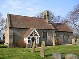
The village church, St James, is a Grade II listed building and houses the oldest dated bell in England
, dated 1254.
Holderness
Holderness is an area of the East Riding of Yorkshire, on the east coast of England. An area of rich agricultural land, Holderness was marshland until it was drained in the Middle Ages. Topographically, Holderness has more in common with the Netherlands than other parts of Yorkshire...
area of the East Riding of Yorkshire
East Riding of Yorkshire
The East Riding of Yorkshire, or simply East Yorkshire, is a local government district with unitary authority status, and a ceremonial county of England. For ceremonial purposes the county also includes the city of Kingston upon Hull, which is a separate unitary authority...
, England
England
England is a country that is part of the United Kingdom. It shares land borders with Scotland to the north and Wales to the west; the Irish Sea is to the north west, the Celtic Sea to the south west, with the North Sea to the east and the English Channel to the south separating it from continental...
. It is situated 6 miles (9.7 km) south of Bridlington
Bridlington
Bridlington is a seaside resort, minor sea fishing port and civil parish on the Holderness Coast of the North Sea, in the East Riding of Yorkshire, England. It has a static population of over 33,000, which rises considerably during the tourist season...
town centre and 13 miles (20.9 km) north east of Beverley
Beverley
Beverley is a market town, civil parish and the county town of the East Riding of Yorkshire, England, located between the River Hull and the Westwood. The town is noted for Beverley Minster and architecturally-significant religious buildings along New Walk and other areas, as well as the Beverley...
town centre on the A165 road
A165 road
The A165 is a road that links Scarborough and Kingston upon Hull, both in Yorkshire, England. It is close to the coast for the northern part of the route...
that connects the two towns.
Together with Ulrome
Ulrome
Ulrome is a village in the East Riding of Yorkshire, England. It is situated approximately north of the town of Hornsea and on the east side of the B1242 road.Together with Lissett it forms the civil parish of Lissett and Ulrome....
it forms the civil parish of Lissett and Ulrome
Lissett and Ulrome
Lissett and Ulrome is a civil parish in the East Riding of Yorkshire, England. It is situated approximately south of Bridlington town centre and covering an area of ....
.
In 1942 an RAF
Royal Air Force
The Royal Air Force is the aerial warfare service branch of the British Armed Forces. Formed on 1 April 1918, it is the oldest independent air force in the world...
station, RAF Lissett
RAF Lissett
RAF Lissett was a Royal Air Force station during the Second World War. Located just to the south of Bridlington, Yorkshire, England. It was named after the nearby village of Lissett.-History:...
was built there. Its main role was to serve as a base for the Halifax Bomber
Handley Page Halifax
The Handley Page Halifax was one of the British front-line, four-engined heavy bombers of the Royal Air Force during the Second World War. A contemporary of the famous Avro Lancaster, the Halifax remained in service until the end of the war, performing a variety of duties in addition to bombing...
158 Squadron
No. 158 Squadron RAF
No. 158 Squadron RAF was a World War I proposed ground attack squadron that did not became operational in time to see action, and a World War II bomber squadron. After World War II had ended in Europe the squadron operated in the transport role until disbandment in December 1945.-Formation in World...
. It had a short life - the final mission left the airbase on 25 April 1945. The airbase is now part of a small industrial estate in the village. In December 2008 a 30 MW wind farm housing 12 turbines each 125 metres (410.1 ft) high was constructed across the western end of the airfield.
The village church, St James, is a Grade II listed building and houses the oldest dated bell in England
England
England is a country that is part of the United Kingdom. It shares land borders with Scotland to the north and Wales to the west; the Irish Sea is to the north west, the Celtic Sea to the south west, with the North Sea to the east and the English Channel to the south separating it from continental...
, dated 1254.