

Linwood, Kansas
Encyclopedia
Linwood is a city in Leavenworth County
, Kansas
, United States
, about 15 miles (24.1 km) east of Lawrence
. As of the 2010 census, the city population was 375.
, the last Delaware
chief. (Sometimes people made fun of the name Journeycake by calling it "Johnny Cake".) The town was platted on both sides of Stranger Creek, near its mouth at the Kansas River
.
In May 1860, a treaty was signed at Sarcoxieville, 3 miles (4.8 km) northeast of Linwood, by Chief Sarcoxie of the Delaware and by the United States. After the treaty's signature, each member of the tribe was assigned a parcel of land, and the balance of the tribe's territories were sold to the predecessor of the Union Pacific Railroad
. Meanwhile, the U.S. government established a trading post near Stranger Creek until the tribe was moved to the Indian Territory
in 1867. Located beside the Union Pacific Railroad tracks, the store became the town’s first school.
began building the main line westward across the Great Plains
from Kansas City, Kansas
, to Denver, Colorado
. This was the long-line railroad in Kansas for 2–3 years. The first 40 miles (64.4 km) was open in 1864 from Wyandotte (now a suburb of Kansas City) to Lawrence. William A. Harris moved to Kansas in 1865 employed as a civil engineer for the Union Pacific Railroad. In 1868 it became the Kansas Pacific Railroad
because it was easier to refer to.
trees that grew in the area. But, according to the Kansas Historical Collections, the town of Stranger had its name changed to Linwood by Senator William A. Harris because of his great appreciation for the linwood trees that were abundant in the vicinity of Stranger Creek.
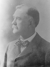 William A. Harris
moved to Kansas in 1865 employed as a civil engineer for the Union Pacific Railroad until 1868, when he moved to Lawrence, Kansas. He was appointed agent for the railroad companies in the sale of the Delaware Reservation and other lands. In 1884 Harris became a prominent citizen of Linwood, where he engaged in agricultural pursuits and stock raising. He bought several 100 acres (404,686 m²) of land just west of Linwood that bordered the town. On a high hill within sight of town he built a modest two story mansion with fifteen rooms, the Harris House. Harris was elected as a Democratic Congressman to the Fifty-third Congress (1893–1895) and as a Populist
to the U.S. Senate (1897–1903). He was an unsuccessful candidate for Governor of Kansas in 1906. Harris died in 1909, and is buried in Lawrence, Kansas.
(affectionately known as the “Kaw” River) that flows eastward to the Missouri. After the 1903 flood damaged and endangered much of the town, it was relocated about one mile (1.6 km) north to its present location out of “the bottoms” (as they are still known today) near the river.
, the city has a total area of 0.4 square miles (1 km²), all of it land.
of 2000, there were 374 people, 129 households, and 87 families residing in the city. The population density
was 902.0 people per square mile (352.2/km²). There were 146 housing units at an average density of 352.1 per square mile (137.5/km²). The racial makeup of the city was 90.11% White, 0.53% African American, 4.01% from other races
, and 5.35% from two or more races. Hispanic or Latino of any race were 7.75% of the population.
There were 129 households out of which 45.0% had children under the age of 18 living with them, 47.3% were married couples
living together, 14.0% had a female householder with no husband present, and 31.8% were non-families. 25.6% of all households were made up of individuals and 8.5% had someone living alone who was 65 years of age or older. The average household size was 2.90 and the average family size was 3.50.
In the city the population was spread out with 35.3% under the age of 18, 12.6% from 18 to 24, 29.9% from 25 to 44, 16.8% from 45 to 64, and 5.3% who were 65 years of age or older. The median age was 27 years. For every 100 females there were 92.8 males. For every 100 females age 18 and over, there were 93.6 males.
The median income for a household in the city was $35,313, and the median income for a family was $39,125. Males had a median income of $26,875 versus $24,896 for females. The per capita income
for the city was $13,008. About 6.1% of families and 7.2% of the population were below the poverty line, including 9.5% of those under age 18 and none of those age 65 or over.
Leavenworth County, Kansas
Leavenworth County is a county located in Northeast Kansas, in the Central United States. As of the 2010 census, the county population was 76,227. Its county seat and most populous city is Leavenworth...
, Kansas
Kansas
Kansas is a US state located in the Midwestern United States. It is named after the Kansas River which flows through it, which in turn was named after the Kansa Native American tribe, which inhabited the area. The tribe's name is often said to mean "people of the wind" or "people of the south...
, United States
United States
The United States of America is a federal constitutional republic comprising fifty states and a federal district...
, about 15 miles (24.1 km) east of Lawrence
Lawrence, Kansas
Lawrence is the sixth largest city in the U.S. State of Kansas and the county seat of Douglas County. Located in northeastern Kansas, Lawrence is the anchor city of the Lawrence, Kansas, Metropolitan Statistical Area, which encompasses all of Douglas County...
. As of the 2010 census, the city population was 375.
Beginnings
Linwood was founded as "Journeycake," being named after Charles JourneycakeCharles Journeycake
Charles Journeycake , was a Christian Indian chief of the Lenape. He visited Washington, D.C. 24 times on behalf of his people starting in 1854.-References:* *...
, the last Delaware
Lenape
The Lenape are an Algonquian group of Native Americans of the Northeastern Woodlands. They are also called Delaware Indians. As a result of the American Revolutionary War and later Indian removals from the eastern United States, today the main groups live in Canada, where they are enrolled in the...
chief. (Sometimes people made fun of the name Journeycake by calling it "Johnny Cake".) The town was platted on both sides of Stranger Creek, near its mouth at the Kansas River
Kansas River
The Kansas River is a river in northeastern Kansas in the United States. It is the southwestern-most part of the Missouri River drainage, which is in turn the northwestern-most portion of the extensive Mississippi River drainage. Its name come from the Kanza people who once inhabited the area...
.
In May 1860, a treaty was signed at Sarcoxieville, 3 miles (4.8 km) northeast of Linwood, by Chief Sarcoxie of the Delaware and by the United States. After the treaty's signature, each member of the tribe was assigned a parcel of land, and the balance of the tribe's territories were sold to the predecessor of the Union Pacific Railroad
Union Pacific Railroad
The Union Pacific Railroad , headquartered in Omaha, Nebraska, is the largest railroad network in the United States. James R. Young is president, CEO and Chairman....
. Meanwhile, the U.S. government established a trading post near Stranger Creek until the tribe was moved to the Indian Territory
Indian Territory
The Indian Territory, also known as the Indian Territories and the Indian Country, was land set aside within the United States for the settlement of American Indians...
in 1867. Located beside the Union Pacific Railroad tracks, the store became the town’s first school.
Union Pacific Railroad
In September 1863, the Union Pacific RailroadUnion Pacific Railroad
The Union Pacific Railroad , headquartered in Omaha, Nebraska, is the largest railroad network in the United States. James R. Young is president, CEO and Chairman....
began building the main line westward across the Great Plains
Great Plains
The Great Plains are a broad expanse of flat land, much of it covered in prairie, steppe and grassland, which lies west of the Mississippi River and east of the Rocky Mountains in the United States and Canada. This area covers parts of the U.S...
from Kansas City, Kansas
Kansas City, Kansas
Kansas City is the third-largest city in the state of Kansas and is the county seat of Wyandotte County. It is a suburb of Kansas City, Missouri, and is the third largest city in the Kansas City Metropolitan Area. The city is part of a consolidated city-county government known as the "Unified...
, to Denver, Colorado
Denver, Colorado
The City and County of Denver is the capital and the most populous city of the U.S. state of Colorado. Denver is a consolidated city-county, located in the South Platte River Valley on the western edge of the High Plains just east of the Front Range of the Rocky Mountains...
. This was the long-line railroad in Kansas for 2–3 years. The first 40 miles (64.4 km) was open in 1864 from Wyandotte (now a suburb of Kansas City) to Lawrence. William A. Harris moved to Kansas in 1865 employed as a civil engineer for the Union Pacific Railroad. In 1868 it became the Kansas Pacific Railroad
Kansas Pacific Railway
The Kansas Pacific Railway was a historic railroad company that operated in the western United States in the late 19th century. It was a federally chartered railroad, backed with government land grants. It operated many of the first long-distance lines in the state of Kansas in the 1870s,...
because it was easier to refer to.
Name change
The original town of Journeycake was officially platted as Stranger on July 11, 1867, and recorded at the Leavenworth County Courthouse. When the name Stranger became a problem for the Postal Service who confused Stranger with a nearby town also named Stranger (referred to as "Big" Stranger), the town was renamed Linwood on December 20, 1877. Legend has it that one day when the townspeople were cutting wood for the church, Colonel Loring suggested they change the name to Linwood, because of the many lindenTilia americana
Tilia americana is a species of Tilia native to eastern North America, from southeast Manitoba east to New Brunswick, southwest to northeast Texas, and southeast to South Carolina, and west along the Niobrara River to Cherry County, Nebraska...
trees that grew in the area. But, according to the Kansas Historical Collections, the town of Stranger had its name changed to Linwood by Senator William A. Harris because of his great appreciation for the linwood trees that were abundant in the vicinity of Stranger Creek.
Senator Harris
William A. Harris (Kansas)
William Alexander Harris was a United States Representative and Senator from Kansas.-Early life and education:...
moved to Kansas in 1865 employed as a civil engineer for the Union Pacific Railroad until 1868, when he moved to Lawrence, Kansas. He was appointed agent for the railroad companies in the sale of the Delaware Reservation and other lands. In 1884 Harris became a prominent citizen of Linwood, where he engaged in agricultural pursuits and stock raising. He bought several 100 acres (404,686 m²) of land just west of Linwood that bordered the town. On a high hill within sight of town he built a modest two story mansion with fifteen rooms, the Harris House. Harris was elected as a Democratic Congressman to the Fifty-third Congress (1893–1895) and as a Populist
Populist Party (United States)
The People's Party, also known as the "Populists", was a short-lived political party in the United States established in 1891. It was most important in 1892-96, then rapidly faded away...
to the U.S. Senate (1897–1903). He was an unsuccessful candidate for Governor of Kansas in 1906. Harris died in 1909, and is buried in Lawrence, Kansas.
Relocation
Much of Linwood’s commerce came from the saw mills on the river, so the town had grown very near the banks of the Kansas RiverKansas River
The Kansas River is a river in northeastern Kansas in the United States. It is the southwestern-most part of the Missouri River drainage, which is in turn the northwestern-most portion of the extensive Mississippi River drainage. Its name come from the Kanza people who once inhabited the area...
(affectionately known as the “Kaw” River) that flows eastward to the Missouri. After the 1903 flood damaged and endangered much of the town, it was relocated about one mile (1.6 km) north to its present location out of “the bottoms” (as they are still known today) near the river.
Geography
Linwood is located at 39°0′3"N 95°2′14"W (39.000722, -95.037199). According to the United States Census BureauUnited States Census Bureau
The United States Census Bureau is the government agency that is responsible for the United States Census. It also gathers other national demographic and economic data...
, the city has a total area of 0.4 square miles (1 km²), all of it land.
Demographics
As of the censusCensus
A census is the procedure of systematically acquiring and recording information about the members of a given population. It is a regularly occurring and official count of a particular population. The term is used mostly in connection with national population and housing censuses; other common...
of 2000, there were 374 people, 129 households, and 87 families residing in the city. The population density
Population density
Population density is a measurement of population per unit area or unit volume. It is frequently applied to living organisms, and particularly to humans...
was 902.0 people per square mile (352.2/km²). There were 146 housing units at an average density of 352.1 per square mile (137.5/km²). The racial makeup of the city was 90.11% White, 0.53% African American, 4.01% from other races
Race (United States Census)
Race and ethnicity in the United States Census, as defined by the Federal Office of Management and Budget and the United States Census Bureau, are self-identification data items in which residents choose the race or races with which they most closely identify, and indicate whether or not they are...
, and 5.35% from two or more races. Hispanic or Latino of any race were 7.75% of the population.
There were 129 households out of which 45.0% had children under the age of 18 living with them, 47.3% were married couples
Marriage
Marriage is a social union or legal contract between people that creates kinship. It is an institution in which interpersonal relationships, usually intimate and sexual, are acknowledged in a variety of ways, depending on the culture or subculture in which it is found...
living together, 14.0% had a female householder with no husband present, and 31.8% were non-families. 25.6% of all households were made up of individuals and 8.5% had someone living alone who was 65 years of age or older. The average household size was 2.90 and the average family size was 3.50.
In the city the population was spread out with 35.3% under the age of 18, 12.6% from 18 to 24, 29.9% from 25 to 44, 16.8% from 45 to 64, and 5.3% who were 65 years of age or older. The median age was 27 years. For every 100 females there were 92.8 males. For every 100 females age 18 and over, there were 93.6 males.
The median income for a household in the city was $35,313, and the median income for a family was $39,125. Males had a median income of $26,875 versus $24,896 for females. The per capita income
Per capita income
Per capita income or income per person is a measure of mean income within an economic aggregate, such as a country or city. It is calculated by taking a measure of all sources of income in the aggregate and dividing it by the total population...
for the city was $13,008. About 6.1% of families and 7.2% of the population were below the poverty line, including 9.5% of those under age 18 and none of those age 65 or over.
Further reading
- History of the State of Kansas; William G. Cutler; A.T. Andreas Publisher; 1883. (Online HTML eBook)
- Kansas : A Cyclopedia of State History, Embracing Events, Institutions, Industries, Counties, Cities, Towns, Prominent Persons, Etc; 3 Volumes; Frank W. Blackmar; Standard Publishing Co; 944 / 955 / 824 pages; 1912. (Volume1 - Download 54MB PDF eBook),(Volume2 - Download 53MB PDF eBook), (Volume3 - Download 33MB PDF eBook)