
Lepe, Hampshire
Encyclopedia
Lepe is a small settlement on the Solent
in the English
county of Hampshire
. It is located at the mouth of the Dark Water
, and is the site of the Lepe Country Park, which runs from Stanswood Bay to the mouth of the Beaulieu River
.
on shore of the Solent
. It is part of the civil parish
of Exbury and Lepe
, which in turn is part of the New Forest district
of Hampshire
. It is home to Lepe Country Park, with a mile of beach, pine-fringed cliffs, historic D-Day remains, and wild flower meadows. There is a cafe-and-shop open all year round.
From the cliff tops above the beach, commanding views of the Western Solent can be achieved resulting in a lookout position for Solent Rescue
Independent Lifeboat station being placed there. Inchmery Quay lies to the west.
times. The evidence for this is the apparent route of a Roman road
, which ran down the eastern side of the New Forest, from the Totton area to Lepe.
Lepe is first recorded in the 13th century. The name may mean "leaping place," perhaps in relation to a jumpable stream, or other such crossing place. It seems to have been part of Exbury
manor, which in later times was frequently called the "manor of Exbury and Lepe."
Tradition says that there was a village at Lepe that was destroyed by a great storm prior to the early 1700s. Two harbours, at Lepe and at Stone Point, are supposed to have been in existence also. Information from old maps shows that the Dark Water
used to flow out to the east of where it does now, near Stone Point. An estate map of 1640 shows a tidal mill was situated at this location, and the tidal pond is still identifiable. If there was a sudden change, then it may have occurred during the Great Storm of 1703
when the south coast of England was ravaged for five days.
Lepe harbour survived, and in 1744 shipbuilder Moody Janverin was asked by the Admiralty
to create a shipyard at Lepe. Among the ships built at Lepe were HMS Greenwich (1747)
, HMS Fowey (1749), and HMS Europa (1765)
. Lepe harbour had silted up by 1825.
Around this time Lepe was involved in the oyster
trade, large heaps of oysters being stacked here to purify. There was also a wooden quay built at Lepe to serve the brickyards in the locality, until the coastal trade gradually diminished with the coming of the railways. A coastguard station was built at Lepe to combat smuggling in the region. Completed in 1828, the Coastguard Cottages and the Watch House remain largely unchanged today.
In the 18th century, Lepe House was an inn, known as The Ship Inn, but it was later enlarged and beautified to become a country house. In 1943, it was requisitioned by the Royal Navy who used it as the base for J.1 Assault Group for the D-Day landings.
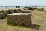
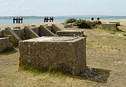 Prior to the invasion of Normandy in June 1944, Lepe was used as a secret manufacturing site. Six massive concrete caissons (type B2 Phoenix breakwaters
) were built here and later towed across the English Channel where they formed part of the artificial Mulberry harbour
s after D-Day
. Lepe was also one of the many places on the south coast of England used for the embarkation of troops and equipment for the invasion. Concrete mats like big chocolate blocks were used to reinforce the shingle beach for heavy traffic. Some of these mats can still be seen today along with pier remnants, bollards and various concrete and brick structures. Lepe was also the point where PLUTO
(Pipeline Under The Ocean) left the mainland. It carried fuel across the Isle of Wight and under the English Channel to the Allied forces in Normandy and beyond.
Solent
The Solent is a strait separating the Isle of Wight from the mainland of England.The Solent is a major shipping route for passengers, freight and military vessels. It is an important recreational area for water sports, particularly yachting, hosting the Cowes Week sailing event annually...
in the English
England
England is a country that is part of the United Kingdom. It shares land borders with Scotland to the north and Wales to the west; the Irish Sea is to the north west, the Celtic Sea to the south west, with the North Sea to the east and the English Channel to the south separating it from continental...
county of Hampshire
Hampshire
Hampshire is a county on the southern coast of England in the United Kingdom. The county town of Hampshire is Winchester, a historic cathedral city that was once the capital of England. Hampshire is notable for housing the original birthplaces of the Royal Navy, British Army, and Royal Air Force...
. It is located at the mouth of the Dark Water
Dark Water (river)
The Dark Water is a river in the English county of Hampshire. The river flows south from a source in the New Forest, reaching the sea through the Solent at Lepe....
, and is the site of the Lepe Country Park, which runs from Stanswood Bay to the mouth of the Beaulieu River
Beaulieu River
The Beaulieu River , formerly known as the River Exe, is a small river flowing south through the New Forest in the county of Hampshire in southern England. The river is some long, of which the last are tidal...
.
Overview
Lepe is a hamletHamlet (place)
A hamlet is usually a rural settlement which is too small to be considered a village, though sometimes the word is used for a different sort of community. Historically, when a hamlet became large enough to justify building a church, it was then classified as a village...
on shore of the Solent
Solent
The Solent is a strait separating the Isle of Wight from the mainland of England.The Solent is a major shipping route for passengers, freight and military vessels. It is an important recreational area for water sports, particularly yachting, hosting the Cowes Week sailing event annually...
. It is part of the civil parish
Civil parish
In England, a civil parish is a territorial designation and, where they are found, the lowest tier of local government below districts and counties...
of Exbury and Lepe
Exbury and Lepe
Exbury and Lepe is a civil parish in the New Forest in Hampshire, England. It is bounded to the west by the Beaulieu River, to the south by the shore of the Solent and to the east by the Dark Water. To the north it extends to the New Forest heathland. The parish includes the settlements of Exbury...
, which in turn is part of the New Forest district
New Forest (district)
New Forest is a local government district in Hampshire, England. It is named after the New Forest.It was created on 1 April 1974, and was a merger of the borough of Lymington, New Forest Rural District and part of Ringwood and Fordingbridge Rural District....
of Hampshire
Hampshire
Hampshire is a county on the southern coast of England in the United Kingdom. The county town of Hampshire is Winchester, a historic cathedral city that was once the capital of England. Hampshire is notable for housing the original birthplaces of the Royal Navy, British Army, and Royal Air Force...
. It is home to Lepe Country Park, with a mile of beach, pine-fringed cliffs, historic D-Day remains, and wild flower meadows. There is a cafe-and-shop open all year round.
From the cliff tops above the beach, commanding views of the Western Solent can be achieved resulting in a lookout position for Solent Rescue
Solent Rescue
Solent Rescue Independent Lifeboat is an inshore rescue lifeboat, not run by the RNLI, based at Lepe Country Park on the north shore of the Solent in Hampshire in England, south of the New Forest. It was set up in 1971 as a beach rescue unit, and developed into a full lifeboat stationThe...
Independent Lifeboat station being placed there. Inchmery Quay lies to the west.
History
It is sometimes said that Lepe was a port in RomanRoman Britain
Roman Britain was the part of the island of Great Britain controlled by the Roman Empire from AD 43 until ca. AD 410.The Romans referred to the imperial province as Britannia, which eventually comprised all of the island of Great Britain south of the fluid frontier with Caledonia...
times. The evidence for this is the apparent route of a Roman road
Roman road
The Roman roads were a vital part of the development of the Roman state, from about 500 BC through the expansion during the Roman Republic and the Roman Empire. Roman roads enabled the Romans to move armies and trade goods and to communicate. The Roman road system spanned more than 400,000 km...
, which ran down the eastern side of the New Forest, from the Totton area to Lepe.
Lepe is first recorded in the 13th century. The name may mean "leaping place," perhaps in relation to a jumpable stream, or other such crossing place. It seems to have been part of Exbury
Exbury
Exbury is a village in Hampshire, England. It lies just in the New Forest, near the Beaulieu River and about a mile from the Solent coast. It is best known as the location of Exbury House, built by the Rothschild family, and the famous Exbury Gardens...
manor, which in later times was frequently called the "manor of Exbury and Lepe."
Tradition says that there was a village at Lepe that was destroyed by a great storm prior to the early 1700s. Two harbours, at Lepe and at Stone Point, are supposed to have been in existence also. Information from old maps shows that the Dark Water
Dark Water (river)
The Dark Water is a river in the English county of Hampshire. The river flows south from a source in the New Forest, reaching the sea through the Solent at Lepe....
used to flow out to the east of where it does now, near Stone Point. An estate map of 1640 shows a tidal mill was situated at this location, and the tidal pond is still identifiable. If there was a sudden change, then it may have occurred during the Great Storm of 1703
Great Storm of 1703
The Great Storm of 1703 was the most severe storm or natural disaster ever recorded in the southern part of Great Britain. It affected southern England and the English Channel in the Kingdom of Great Britain...
when the south coast of England was ravaged for five days.
Lepe harbour survived, and in 1744 shipbuilder Moody Janverin was asked by the Admiralty
Admiralty
The Admiralty was formerly the authority in the Kingdom of England, and later in the United Kingdom, responsible for the command of the Royal Navy...
to create a shipyard at Lepe. Among the ships built at Lepe were HMS Greenwich (1747)
HMS Greenwich (1747)
HMS Greenwich was a 50-gun fourth rate ship of the line of the Royal Navy. She was built during the War of the Austrian Succession, and went on to see action in the Seven Years' War, during which she was captured by the French and taken into their service under the same name...
, HMS Fowey (1749), and HMS Europa (1765)
HMS Europa (1765)
HMS Europa was a 64-gun third rate ship of the line of the Royal Navy, launched on 21 April 1765 at Lepe, Hampshire. She was renamed HMS Europe in 1778, and spent the rest of her career under this name....
. Lepe harbour had silted up by 1825.
Around this time Lepe was involved in the oyster
Oyster
The word oyster is used as a common name for a number of distinct groups of bivalve molluscs which live in marine or brackish habitats. The valves are highly calcified....
trade, large heaps of oysters being stacked here to purify. There was also a wooden quay built at Lepe to serve the brickyards in the locality, until the coastal trade gradually diminished with the coming of the railways. A coastguard station was built at Lepe to combat smuggling in the region. Completed in 1828, the Coastguard Cottages and the Watch House remain largely unchanged today.
In the 18th century, Lepe House was an inn, known as The Ship Inn, but it was later enlarged and beautified to become a country house. In 1943, it was requisitioned by the Royal Navy who used it as the base for J.1 Assault Group for the D-Day landings.
Lepe and D-Day, 1944
Phoenix breakwaters
The Phoenix breakwaters were a set of reinforced concrete caissons built as part of the artificial Mulberry harbours that were assembled as part of the follow-up to the Normandy landings during World War II. They were constructed by civil engineering contractors around the coast of Britain...
) were built here and later towed across the English Channel where they formed part of the artificial Mulberry harbour
Mulberry harbour
A Mulberry harbour was a British type of temporary harbour developed in World War II to offload cargo on the beaches during the Allied invasion of Normandy....
s after D-Day
D-Day
D-Day is a term often used in military parlance to denote the day on which a combat attack or operation is to be initiated. "D-Day" often represents a variable, designating the day upon which some significant event will occur or has occurred; see Military designation of days and hours for similar...
. Lepe was also one of the many places on the south coast of England used for the embarkation of troops and equipment for the invasion. Concrete mats like big chocolate blocks were used to reinforce the shingle beach for heavy traffic. Some of these mats can still be seen today along with pier remnants, bollards and various concrete and brick structures. Lepe was also the point where PLUTO
Pluto
Pluto, formal designation 134340 Pluto, is the second-most-massive known dwarf planet in the Solar System and the tenth-most-massive body observed directly orbiting the Sun...
(Pipeline Under The Ocean) left the mainland. It carried fuel across the Isle of Wight and under the English Channel to the Allied forces in Normandy and beyond.