
Layou
Encyclopedia
- There is also a village and riverLayou RiverThe Layou River is a river in Dominica. It rises in the interior of the country, flowing westward to reach the Caribbean Sea on the country's central western coast, very close to the town of St. Joseph.-External links:...
in DominicaDominicaDominica , officially the Commonwealth of Dominica, is an island nation in the Lesser Antilles region of the Caribbean Sea, south-southeast of Guadeloupe and northwest of Martinique. Its size is and the highest point in the country is Morne Diablotins, which has an elevation of . The Commonwealth...
named Layou.
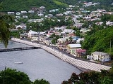
Layou is a small town located on the island of Saint Vincent
Saint Vincent (island)
Saint Vincent is a volcanic island in the Caribbean. It is the largest island of the chain called Saint Vincent and the Grenadines. It is located in the Caribbean Sea, between Saint Lucia and Grenada. It is composed of partially submerged volcanic mountains...
, in Saint Andrew Parish
Saint Andrew Parish, Saint Vincent and the Grenadines
Saint Andrew is an administrative parish of Saint Vincent and the Grenadines, on the island of Saint Vincent. Its capital is Layou.* Area: 29 km² * Population: 6,700 -External links:* , Statoids.com...
. There is a post office
Post office
A post office is a facility forming part of a postal system for the posting, receipt, sorting, handling, transmission or delivery of mail.Post offices offer mail-related services such as post office boxes, postage and packaging supplies...
, a police station and a library
Library
In a traditional sense, a library is a large collection of books, and can refer to the place in which the collection is housed. Today, the term can refer to any collection, including digital sources, resources, and services...
. There are also two quarries.
History
Layou is located on the western coast of Saint Vincent and the GrenadinesSaint Vincent and the Grenadines
Saint Vincent and the Grenadines is an island country in the Lesser Antilles chain, namely in the southern portion of the Windward Islands, which lie at the southern end of the eastern border of the Caribbean Sea where the latter meets the Atlantic Ocean....
and was one of the first areas of settlement by the French, who were the first Europeans to settle in St. Vincent and The Grenadines in the early part of the eighteenth century. Even before then the Caribs used it as one of their settlements, as it is evident from the Petroglyphs which are found in the area.
In 1763 St. Vincent was taken over by the British and the lands in Layou were bought by them to cultivate sugar. Layou was still a small area formed around Ruthland Bay. The cultivation of sugar cane started growing and larger estates were needed, so that the smaller holdings of the French were consolidated into larger estates.
There were 3 main estates: Ruthland Vale estate, Akers estate and Palmiste Park estate. During slavery
Slavery
Slavery is a system under which people are treated as property to be bought and sold, and are forced to work. Slaves can be held against their will from the time of their capture, purchase or birth, and deprived of the right to leave, to refuse to work, or to demand compensation...
, most people lived on the estates but began to leave after slavery was abolished and to establish villages.
Immediately after Emancipation, the lands of one of the estates, Akers, were sold to form Cowdrey's Village. In 1861 Layou had a population of 140 people, Cowdrey's Village 227, while 333 people lived on the Ruthland Vale estate, 15 on what remained of the Akers estate and just five at the Palmiste Park estate.
The Ruthland Vale estate was sold after the eruption of the La Soufriere volcano in 1902. 450 acres (1.8 km²) were set aside for refugees from areas affected by the eruption.
Other changes began to take place in the area. The owner of what remained of the Ruthland Vale estates began to sell land to residents of Layou, and also residents of the estates began to move into Layou because employment possibilities on the estates were decreasing. Added to this, estate residents wanted to take advantage of social amenities, the school, clinic
Clinic
A clinic is a health care facility that is primarily devoted to the care of outpatients...
, church and cricket pitch
Cricket pitch
In the game of cricket, the cricket pitch consists of the central strip of the cricket field between the wickets - 1 chain or 22 yards long and 10 feet wide. The surface is very flat and normally covered with extremely short grass though this grass is soon removed by wear at the ends of the...
among others. This led to an increase in population of Layou and also an enlargement of the town, since many of the smaller villages and estates settlements eventually became incorporated into the town of Layou.
Layou is Located in the Constituency of Central Leeward.
Geography
Layou is located on the western coast of the island of Saint Vincent and the GrenadinesSaint Vincent and the Grenadines
Saint Vincent and the Grenadines is an island country in the Lesser Antilles chain, namely in the southern portion of the Windward Islands, which lie at the southern end of the eastern border of the Caribbean Sea where the latter meets the Atlantic Ocean....
.Located after the small fishing village of Buccament and before the town of Barrouallie
Barrouallie
Barrouallie is a town located on the island of Saint Vincent. Within Saint Patrick Parish Barrouallie is both the largest city and the parish capital. Once it was the capital of St.Vincent and the Grenadines....
on the Central leeward highway.
Climate
Layou has a seasonal tropical climate with a wet season lasting from May to November and a dry season lasting from January to MayUrban Structure
Layou is divided up into various sectionsEast:
- Cowdrey's Village
- Akers
Downtown:
- Bottom Garden
- Plan
- Bethrome
Uptown
- Swamp Gut
- Texier
- Ruthland Vale
West
- Bambereux
Education
Layou serves as an important educational centre for the people of layou and buccament. The layou Government School is located downtown in the Plan district of Layou. The Louis Straker Resource Centre is also an educational facility for evening classes and learning and literacy programs.The Waterfront Project
For years the beautiful Leeward town of Layou has been threatened by the ocean. Years of wave action had seriously eroded the coastline threatening the main highway and access to the communities further north. In the late 1990s three storms wreaked havoc on the Layou waterfront and the problem became so critical that Government decided to move quickly to correct the situation.A parliamentary representative for the area visited the site in July 2002 and promised to transform the area. Four years later in 2006, the waterfront project was considered completed. Today it is a very beautiful site in the town of Layou. Various activities are held at the Layou waterfront, such as the Nine Morning celebration which was Introduced in 2007.
Transportation
Transportation in Layou is relatively easy. Omnibuses provide transportation to and from Layou.Petroglyphs
The Petroglyphs in Layou are located a short distance inland from the Leeward Highway in Layou. They are more visible if you outline them with a chalk, or get a local child to do it for you. They were made by the Caribs when they settled there before the eighteenth century.
Christmas Lighting
Layou has its annual Christmas lighting where the waterfront boardwalk becomes filled with Christmas lights and decorations to welcome the festive season