

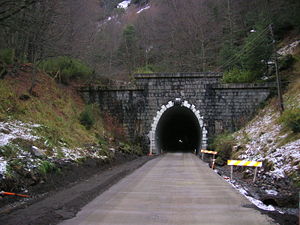
Las Raíces Tunnel
Encyclopedia
Andes
The Andes is the world's longest continental mountain range. It is a continual range of highlands along the western coast of South America. This range is about long, about to wide , and of an average height of about .Along its length, the Andes is split into several ranges, which are separated...
and is the second longest of South America (after the 2006 inauguration of the 4600 metres (15,091.9 ft) long tunnel Fernando Gómez Martínez in Colombia). It is located about 700 km south of Santiago de Chile on the paved Route 181-CH
Route 181-CH
thumb|200px|Route 181-CHthumb|200px|[[Las Raíces Tunnel]], part of Route 181-CHRoute 181-CH is a branch line road going eastward from Chile Highway 5 at Victoria to Pino Hachado Pass at the border to Argentina. Through its length the road passes along or close to the cities and towns of Victoria...
connecting the city of Temuco
Temuco
Temuco is a city and commune, capital of the Cautín Province and of the Araucanía Region in southern Chile. The name comes from the Mapudungun language, meaning "temu water"; "temu" is a tree used by Mapuches for medicinal purposes. The city is located 670 km south of Santiago...
with the pass
Mountain pass
A mountain pass is a route through a mountain range or over a ridge. If following the lowest possible route, a pass is locally the highest point on that route...
Pino Hachado
Pino Hachado Pass
Pino Hachado Pass is a mountain pass through the Andes, joining Chile and Argentina. It is one of the principal passes of the southern Andes, connecting Argentina's route RN-22 and Chile's Route 181-CH....
towards Argentina
Argentina
Argentina , officially the Argentine Republic , is the second largest country in South America by land area, after Brazil. It is constituted as a federation of 23 provinces and an autonomous city, Buenos Aires...
. As such, the tunnel serves as a link between the Pacific
Pacific Ocean
The Pacific Ocean is the largest of the Earth's oceanic divisions. It extends from the Arctic in the north to the Southern Ocean in the south, bounded by Asia and Australia in the west, and the Americas in the east.At 165.2 million square kilometres in area, this largest division of the World...
and Atlantic Ocean
Atlantic Ocean
The Atlantic Ocean is the second-largest of the world's oceanic divisions. With a total area of about , it covers approximately 20% of the Earth's surface and about 26% of its water surface area...
s, from Lebu
Lebu, Chile
Lebu is a port city and commune in central Chile administered by the Municipality of Lebu. Lebu is also the capital of Arauco Province in Bío-Bío Region...
in Chile to Bahía Blanca
Bahía Blanca
Bahía Blanca is a city located in the south-west of the province of Buenos Aires, Argentina, by the Atlantic Ocean, and seat of government of Bahía Blanca Partido. It has a population of 274,509 inhabitants according to the...
in Argentina. It is 4528 metres (14,855.6 ft) long, located 1010 metres (3,313.6 ft) above sea level
Sea level
Mean sea level is a measure of the average height of the ocean's surface ; used as a standard in reckoning land elevation...
and was inaugurated in 1939.
This tunnel allows only one-way traffic which is regulated by a toll station where a fee of approx. 1 Dollar
Dollar
The dollar is the name of the official currency of many countries, including Australia, Belize, Canada, Ecuador, El Salvador, Hong Kong, New Zealand, Singapore, Taiwan, and the United States.-Etymology:...
per car is charged. Its average traffic is about 450 vehicles daily, including some heavy fuel trucks coming from Argentina. An alternative to this tunnel is the old scenic gravel road Cuesta de Las Raíces to be taken northwards about 5 km before the western or 11 km before the eastern entrance.
Feasibility studies began in 1911, with final blueprints ready in 1929. Construction began in 1930 and lasted eight years, with an investment of more than 32 million Chilean peso
Chilean peso
The peso is the currency of Chile. The current peso has circulated since 1975, with a previous version circulating between 1817 and 1960. The symbol used locally for it is $. The ISO 4217 code for the present peso is CLP. It is subdivided into 100 centavos, although no centavo denominated coins...
s of that time. It is 4.2 m wide and 5.6 m high. A railway operated through it from 1956.
Sources
- http://edelect.latercera.cl/medio/articulo/0,0,3255_5666_107831743,00.html
- http://lonquimay.relacionarse.com/index.php/147146