
Lampasas, Texas
Encyclopedia
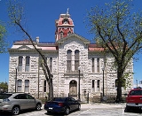
Lampasas is a city in Lampasas County
, Texas
, United States
. The population was 6,786 at the 2000 census. It is the seat
of Lampasas County
.
Lampasas is part of the Killeen
–Temple
–Fort Hood Metropolitan Statistical Area
.
, John Burleson received 1280 acres (5.2 km²) of land and established a permanent settlement in the 1850s. The city was first named Burleson; however, the name was gradually changed to Lampasas Springs because of the existence of seven mineral springs. When the county was created in 1856, the law specified “The county seat shall be same name as the county.” The city of Lampasas was officially incorporated in 1883.
Several theories attempt to explain how the name Lampasas came to be. The Texas Almanac
states the word came from a Spanish word for “lilies” that are found in nearby streams. Another source states the word comes from the Spanish word “Lampazos.” The name was given to the local river by the Spanish Aquayo Expedition in 1721. It is believed the name was inspired by a Mexican town that also had beautiful springs. The town was also the location of the birth of the Farmers' Alliance, founded in 1876.
Since 1972, Lampasas has held an annual fair called the Spring Ho festival each July.http://www.springho.com/
Like nearby Mineral Wells
, Lampasas has mineral springs health spas which once claimed to cure "everything." The 25-bed Rollins Brook Community Hospital in Lampasas was established by two physicians in 1935, one of whom was Herbert Bailey Rollins, originally from Pineville
, Kentucky
. In 1958, Rollins Brook was the smallest accredited hospital in Texas. In 1981, Rollins was sold to a for-profit health care provider in Houston
. Over the next decade the hospital passed through the control of a succession of multiple owners. In 1991, the hospital declared bankruptcy and closed its doors without notice. Thereafter, citizens, unable to locate government or foundation grants, raised some $600,000 in community fund-raising activities to reclaim the facility. When it reopened on July 21, 1991, Rollins Brook became the only community hospital to survive bankruptcy. The story was broadcast by ABC
News with Peter Jennings
. In 1997, the hospital was sold again, this time to the Seventh Day Adventist Church. In 2005, Rollins Brook opened a new surgical section.
According to the United States Census Bureau
, the city has a total area of 6.3 square miles (16.1 km²), of which, 6.2 square miles (16.1 km²) of it is land and 0.04 square mile (0.1035995244 km²) of it (0.64%) is water.
of 2000, there were 6,786 people, 2,554 households, and 1,711 families residing in the city. The population density
was 1,097.3 people per square mile (424.0/km²). There were 2,799 housing units at an average density of 452.6 per square mile (174.9/km²). The racial makeup of the city was 84.78% White, 2.03% African American, 0.71% Native American, 0.57% Asian, 0.07% Pacific Islander, 10.06% from other races
, and 1.77% from two or more races. Hispanic or Latino of any race were 23.11% of the population.
There were 2,554 households out of which 33.7% had children under the age of 18 living with them, 48.4% were married couples
living together, 13.9% had a female householder with no husband present, and 33.0% were non-families. 29.5% of all households were made up of individuals and 16.1% had someone living alone who was 65 years of age or older. The average household size was 2.54 and the average family size was 3.13.
In the city the population was spread out with 27.6% under the age of 18, 8.2% from 18 to 24, 25.2% from 25 to 44, 20.2% from 45 to 64, and 18.8% who were 65 years of age or older. The median age was 36 years. For every 100 females there were 88.9 males. For every 100 females age 18 and over, there were 84.0 males.
The median income for a household in the city was $27,898, and the median income for a family was $31,012. Males had a median income of $26,606 versus $19,959 for females. The per capita income
for the city was $13,409. About 18.3% of families and 21.1% of the population were below the poverty line, including 28.5% of those under age 18 and 16.9% of those age 65 or over.
Lampasas County, Texas
Lampasas County is a county located on the Edwards Plateau in the U.S. state of Texas. In 2000, its population was 17,762. Its seat is Lampasas. The county is named for the Lampasas River....
, Texas
Texas
Texas is the second largest U.S. state by both area and population, and the largest state by area in the contiguous United States.The name, based on the Caddo word "Tejas" meaning "friends" or "allies", was applied by the Spanish to the Caddo themselves and to the region of their settlement in...
, United States
United States
The United States of America is a federal constitutional republic comprising fifty states and a federal district...
. The population was 6,786 at the 2000 census. It is the seat
County seat
A county seat is an administrative center, or seat of government, for a county or civil parish. The term is primarily used in the United States....
of Lampasas County
Lampasas County, Texas
Lampasas County is a county located on the Edwards Plateau in the U.S. state of Texas. In 2000, its population was 17,762. Its seat is Lampasas. The county is named for the Lampasas River....
.
Lampasas is part of the Killeen
Killeen, Texas
Killeen is a city in Bell County, Texas, The United States. The population was 86,911 at the 2000 census. As of 2009, Killeen had 119,510 people. In 2010 Killeen's population shot to 127,921...
–Temple
Temple, Texas
Temple is a city in Bell County, Texas, United States. Located near the county seat of Belton, Temple lies in the region referred to as Central Texas. Located off Interstate 35, Temple is 65 miles north of Austin and 34 miles south of Waco. In the 2010 Census, Temple's population was 66,102, an...
–Fort Hood Metropolitan Statistical Area
Killeen-Temple-Fort Hood metropolitan area
The Killeen-Temple-Fort Hood Metropolitan Statistical Area is a metropolitan area in Central Texas that covers three counties - Bell, Coryell, and Lampasas...
.
History
For his services in the Texas RevolutionTexas Revolution
The Texas Revolution or Texas War of Independence was an armed conflict between Mexico and settlers in the Texas portion of the Mexican state Coahuila y Tejas. The war lasted from October 2, 1835 to April 21, 1836...
, John Burleson received 1280 acres (5.2 km²) of land and established a permanent settlement in the 1850s. The city was first named Burleson; however, the name was gradually changed to Lampasas Springs because of the existence of seven mineral springs. When the county was created in 1856, the law specified “The county seat shall be same name as the county.” The city of Lampasas was officially incorporated in 1883.
Several theories attempt to explain how the name Lampasas came to be. The Texas Almanac
Texas Almanac
The Texas Almanac is a biennially published reference work providing information for the general public on the history of the state and its people, government and politics, economics, natural resources, holidays, culture, education, recreation, the arts, and other topics...
states the word came from a Spanish word for “lilies” that are found in nearby streams. Another source states the word comes from the Spanish word “Lampazos.” The name was given to the local river by the Spanish Aquayo Expedition in 1721. It is believed the name was inspired by a Mexican town that also had beautiful springs. The town was also the location of the birth of the Farmers' Alliance, founded in 1876.
Since 1972, Lampasas has held an annual fair called the Spring Ho festival each July.http://www.springho.com/
Like nearby Mineral Wells
Mineral Wells, Texas
Mineral Wells is a city in Palo Pinto and Parker counties in the U.S. state of Texas. The population was 16,946 at the 2000 census. The city is named for mineral springs in the area, which were highly popular in the early 1900s...
, Lampasas has mineral springs health spas which once claimed to cure "everything." The 25-bed Rollins Brook Community Hospital in Lampasas was established by two physicians in 1935, one of whom was Herbert Bailey Rollins, originally from Pineville
Pineville, Kentucky
Pineville is a city in Bell County, Kentucky, United States. The population was 2,093 at the 2000 census. It is the county seat of Bell County. It is located on a small strip of land between the Cumberland River and Pine Mountain.-History:...
, Kentucky
Kentucky
The Commonwealth of Kentucky is a state located in the East Central United States of America. As classified by the United States Census Bureau, Kentucky is a Southern state, more specifically in the East South Central region. Kentucky is one of four U.S. states constituted as a commonwealth...
. In 1958, Rollins Brook was the smallest accredited hospital in Texas. In 1981, Rollins was sold to a for-profit health care provider in Houston
Houston, Texas
Houston is the fourth-largest city in the United States, and the largest city in the state of Texas. According to the 2010 U.S. Census, the city had a population of 2.1 million people within an area of . Houston is the seat of Harris County and the economic center of , which is the ...
. Over the next decade the hospital passed through the control of a succession of multiple owners. In 1991, the hospital declared bankruptcy and closed its doors without notice. Thereafter, citizens, unable to locate government or foundation grants, raised some $600,000 in community fund-raising activities to reclaim the facility. When it reopened on July 21, 1991, Rollins Brook became the only community hospital to survive bankruptcy. The story was broadcast by ABC
American Broadcasting Company
The American Broadcasting Company is an American commercial broadcasting television network. Created in 1943 from the former NBC Blue radio network, ABC is owned by The Walt Disney Company and is part of Disney-ABC Television Group. Its first broadcast on television was in 1948...
News with Peter Jennings
Peter Jennings
Peter Charles Archibald Ewart Jennings, CM was a Canadian American journalist and news anchor. He was the sole anchor of ABC's World News Tonight from 1983 until his death in 2005 of complications from lung cancer...
. In 1997, the hospital was sold again, this time to the Seventh Day Adventist Church. In 2005, Rollins Brook opened a new surgical section.
Geography
Lampasas is located at 31°3′57"N 98°11′0"W (31.065868, -98.183444).According to the United States Census Bureau
United States Census Bureau
The United States Census Bureau is the government agency that is responsible for the United States Census. It also gathers other national demographic and economic data...
, the city has a total area of 6.3 square miles (16.1 km²), of which, 6.2 square miles (16.1 km²) of it is land and 0.04 square mile (0.1035995244 km²) of it (0.64%) is water.
Demographics
As of the censusCensus
A census is the procedure of systematically acquiring and recording information about the members of a given population. It is a regularly occurring and official count of a particular population. The term is used mostly in connection with national population and housing censuses; other common...
of 2000, there were 6,786 people, 2,554 households, and 1,711 families residing in the city. The population density
Population density
Population density is a measurement of population per unit area or unit volume. It is frequently applied to living organisms, and particularly to humans...
was 1,097.3 people per square mile (424.0/km²). There were 2,799 housing units at an average density of 452.6 per square mile (174.9/km²). The racial makeup of the city was 84.78% White, 2.03% African American, 0.71% Native American, 0.57% Asian, 0.07% Pacific Islander, 10.06% from other races
Race (United States Census)
Race and ethnicity in the United States Census, as defined by the Federal Office of Management and Budget and the United States Census Bureau, are self-identification data items in which residents choose the race or races with which they most closely identify, and indicate whether or not they are...
, and 1.77% from two or more races. Hispanic or Latino of any race were 23.11% of the population.
There were 2,554 households out of which 33.7% had children under the age of 18 living with them, 48.4% were married couples
Marriage
Marriage is a social union or legal contract between people that creates kinship. It is an institution in which interpersonal relationships, usually intimate and sexual, are acknowledged in a variety of ways, depending on the culture or subculture in which it is found...
living together, 13.9% had a female householder with no husband present, and 33.0% were non-families. 29.5% of all households were made up of individuals and 16.1% had someone living alone who was 65 years of age or older. The average household size was 2.54 and the average family size was 3.13.
In the city the population was spread out with 27.6% under the age of 18, 8.2% from 18 to 24, 25.2% from 25 to 44, 20.2% from 45 to 64, and 18.8% who were 65 years of age or older. The median age was 36 years. For every 100 females there were 88.9 males. For every 100 females age 18 and over, there were 84.0 males.
The median income for a household in the city was $27,898, and the median income for a family was $31,012. Males had a median income of $26,606 versus $19,959 for females. The per capita income
Per capita income
Per capita income or income per person is a measure of mean income within an economic aggregate, such as a country or city. It is calculated by taking a measure of all sources of income in the aggregate and dividing it by the total population...
for the city was $13,409. About 18.3% of families and 21.1% of the population were below the poverty line, including 28.5% of those under age 18 and 16.9% of those age 65 or over.