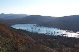
Lago di Doberdò
Encyclopedia
Lake Doberdò is the name of a sinkhole
in the Province of Gorizia
, Friuli-Venezia Giulia
, Italy
. It is located on the westernmost edge of the Karst
plateau, close to the border with Slovenia
. It is named after the village of Doberdò .
It has an area of approximately 0.36 km², depending on the time of year, and it is located around 2 km southwest of the village of Doberdò, not far from the Adriatic coast. The water is filtered through various ponor
s, and it is connected with the springs feeding the Timavo
River, which are located a few kilometers southeast. The depth varies from 5 to 10 m. The lake is usually largest in autumn, when it is 1.2 km long and 350 m wide. During the frequent drought
periods, the lake almost completely disappears, becoming a marsh
-like area.
Sinkhole
A sinkhole, also known as a sink, shake hole, swallow hole, swallet, doline or cenote, is a natural depression or hole in the Earth's surface caused by karst processes — the chemical dissolution of carbonate rocks or suffosion processes for example in sandstone...
in the Province of Gorizia
Province of Gorizia
The Province of Gorizia is a province in the autonomous Friuli–Venezia Giulia region of Italy.-Overview:Its capital is the city of Gorizia. It belonged to the Province of Udine between 1924 and 1927 and the communes of Sonzia, Plezzo, Bergogna, Caporetto, Tolmino, Circhina, Santa Lucia d'Isonzo,...
, Friuli-Venezia Giulia
Friuli-Venezia Giulia
Friuli–Venezia Giulia is one of the twenty regions of Italy, and one of five autonomous regions with special statute. The capital is Trieste. It has an area of 7,858 km² and about 1.2 million inhabitants. A natural opening to the sea for many Central European countries, the region is...
, Italy
Italy
Italy , officially the Italian Republic languages]] under the European Charter for Regional or Minority Languages. In each of these, Italy's official name is as follows:;;;;;;;;), is a unitary parliamentary republic in South-Central Europe. To the north it borders France, Switzerland, Austria and...
. It is located on the westernmost edge of the Karst
Kras
Karst ; also known as the Karst Plateau, is a limestone borderline plateau region extending in southwestern Slovenia and northeastern Italy. It lies between the Vipava Valley, the low hills surrounding the valley, the westernmost part of the Brkini Hills, northern Istria, and the Gulf of Trieste...
plateau, close to the border with Slovenia
Slovenia
Slovenia , officially the Republic of Slovenia , is a country in Central and Southeastern Europe touching the Alps and bordering the Mediterranean. Slovenia borders Italy to the west, Croatia to the south and east, Hungary to the northeast, and Austria to the north, and also has a small portion of...
. It is named after the village of Doberdò .
It has an area of approximately 0.36 km², depending on the time of year, and it is located around 2 km southwest of the village of Doberdò, not far from the Adriatic coast. The water is filtered through various ponor
Ponor
A ponor is a natural surface opening that may be found in landscapes where the geology and the geomorphology is characterized by some kind of karst....
s, and it is connected with the springs feeding the Timavo
Timavo
The River, known in Slovene as the or , is a 2-km river in the Province of Trieste. It has four sources near San Giovanni near Duino and outflows in the Gulf of Panzano between Trieste and Monfalcone , Italy....
River, which are located a few kilometers southeast. The depth varies from 5 to 10 m. The lake is usually largest in autumn, when it is 1.2 km long and 350 m wide. During the frequent drought
Drought
A drought is an extended period of months or years when a region notes a deficiency in its water supply. Generally, this occurs when a region receives consistently below average precipitation. It can have a substantial impact on the ecosystem and agriculture of the affected region...
periods, the lake almost completely disappears, becoming a marsh
Marsh
In geography, a marsh, or morass, is a type of wetland that is subject to frequent or continuous flood. Typically the water is shallow and features grasses, rushes, reeds, typhas, sedges, other herbaceous plants, and moss....
-like area.

