
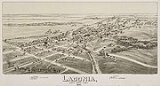
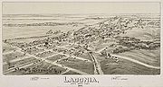
Ladonia, Texas
Encyclopedia
Fannin County, Texas
As of the census of 2000, there were 31,242 people, 11,105 households, and 7,984 families residing in the county. The population density was 35 people per square mile . There were 12,887 housing units at an average density of 14 per square mile...
, Texas
Texas
Texas is the second largest U.S. state by both area and population, and the largest state by area in the contiguous United States.The name, based on the Caddo word "Tejas" meaning "friends" or "allies", was applied by the Spanish to the Caddo themselves and to the region of their settlement in...
, United States
United States
The United States of America is a federal constitutional republic comprising fifty states and a federal district...
. The population was 667 at the 2000 census, and had increased to 691 by 2009.
History
The area was first settled around 1840 and originally called McCownville. the first known permanent settlement in this part of Texas was at a point one mile east of Ladonia, where there now stands the picturesque Colonial building known as the "Old Donalson Place".It seems that the sandy strip of country upon which the present Santa Fe railway runs was the most inviting route used by the early comers to this territory. This was perhaps because it was open prairie and rather highter than the surrounding country, enabling campers to see long distnaces and thus prevent surprise attacks by Indians and maurauding Mexican bands.
It was in this remote time that there came from across the Father of the Waters, in Tennessee, the family of one Jimmie Donalson and pitched a camp in a clump of trees at the above mentioned spot. This was at a time when the immortal Sam Houston was resting in the wigwam of his foster father , Oo-loo-te-ka, getting his bearings and contemplating things to come.
The soothing effect of the beautiful prairie flowers and other attractive surroundings decided Uncle Jimmie to end his wanderings and establish a home; so, the camp was converted into permanent quarters ,buildings were erected lands improved and thus there came to be what was later known throughout the surrounding .... El Rancho La Donalson.
The place was known as the refuge and resting place for any weary traveler wending his way westward. Yes, it was known that a hearty welcome awaited any and all comers to stop over and partake of the hospitality of the "La Donalson".
As time passed, Sam Houston emerged from his hiding place, Texas became a Republic, and through the influence of the President of the United States, Andrew Jackson, and "Aunt Rachel" (Donalson) Jackson, it finally became a state. Along with these many changes, J. Stoke Donalson, Uncle Jimmie's son, became the head of the house and also succeeded to the honor of continuing the traditional policy of welcome to strangers. It has been said that no stranger was ever turned away from this abode in all the years since it was established.
The story is perhaps not being told in the proper chronological order, but at a time before this, ther ehad been located a trading post or village near the point "La Donalson" and then and there was born the city of Ladonia -- which name, as you can easily figure out, is a contraction of the name "La Donalson" in to LaDona or Ladonia.
http://www.rootsweb.ancestry.com/~txfannin/ladhistory.html
The population grew late in the 19th century when three railroads, the Gulf, Colorado, and Sante Fe. Ladonia became a shipping point for corn, cotton, and grain crops. Because of this, the population rapidly increased to 1,500 in the 1890s and peaked at over 2,000 by the turn of the century. However, Ladonia suffered through the Great Depression. At a population of 1,199 afterwards, it never recovered as continued to drop to 658 in 1990. The population did, however, increase ever so slightly to 667 in 2000 and 691 before the end of the decade.
Geography
Ladonia is located at 33°25′46"N 95°56′48"W (33.429336, -95.946668).According to the United States Census Bureau
United States Census Bureau
The United States Census Bureau is the government agency that is responsible for the United States Census. It also gathers other national demographic and economic data...
, the town has a total area of 1.8 square miles (4.7 km²), all of it land.
Demographics
As of the censusCensus
A census is the procedure of systematically acquiring and recording information about the members of a given population. It is a regularly occurring and official count of a particular population. The term is used mostly in connection with national population and housing censuses; other common...
of 2000, there were 667 people, 266 households, and 188 families residing in the town. The population density
Population density
Population density is a measurement of population per unit area or unit volume. It is frequently applied to living organisms, and particularly to humans...
was 363.5 people per square mile (140.7/km²). There were 316 housing units at an average density of 172.2 per square mile (66.7/km²). The racial makeup of the town was 70.61% White, 25.34% African American, 0.75% Asian, 1.65% from other races
Race (United States Census)
Race and ethnicity in the United States Census, as defined by the Federal Office of Management and Budget and the United States Census Bureau, are self-identification data items in which residents choose the race or races with which they most closely identify, and indicate whether or not they are...
, and 1.65% from two or more races. Hispanic or Latino of any race were 2.55% of the population.
There were 266 households out of which 28.9% had children under the age of 18 living with them, 44.7% were married couples
Marriage
Marriage is a social union or legal contract between people that creates kinship. It is an institution in which interpersonal relationships, usually intimate and sexual, are acknowledged in a variety of ways, depending on the culture or subculture in which it is found...
living together, 20.7% had a female householder with no husband present, and 29.3% were non-families. 25.9% of all households were made up of individuals and 14.3% had someone living alone who was 65 years of age or older. The average household size was 2.51 and the average family size was 2.97.
In the town the population was spread out with 26.4% under the age of 18, 8.2% from 18 to 24, 24.4% from 25 to 44, 24.3% from 45 to 64, and 16.6% who were 65 years of age or older. The median age was 38 years. For every 100 females there were 89.0 males. For every 100 females age 18 and over, there were 86.7 males.
The median income for a household in the town was $26,389, and the median income for a family was $31,591. Males had a median income of $26,806 versus $19,615 for females. The per capita income
Per capita income
Per capita income or income per person is a measure of mean income within an economic aggregate, such as a country or city. It is calculated by taking a measure of all sources of income in the aggregate and dividing it by the total population...
for the town was $13,851. About 18.9% of families and 24.6% of the population were below the poverty line, including 34.3% of those under age 18 and 30.2% of those age 65 or over.