
La Oliva
Encyclopedia
- For the monastery in NavarreNavarreNavarre , officially the Chartered Community of Navarre is an autonomous community in northern Spain, bordering the Basque Country, La Rioja, and Aragon in Spain and Aquitaine in France...
, see Santa María de la OlivaSanta María de la OlivaThe abbey of Santa María la Real de la Oliva, or simply La Oliva, is an active Cistercian monastery in Carcastillo, Navarre, Spain.Construction at the site is attributed first in 1134 to King García Ramírez of Navarre, known as the restorer....
.
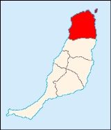
La Oliva (la oliˈβa) is a Canarian municipality in the northern portion of the island of Fuerteventura
Fuerteventura
Fuerteventura , a Spanish island, is one of the Canary Islands, in the Atlantic Ocean off the coast of Africa. It is situated at 28°20' north, 14°00' west. At 1,660 km² it is the second largest of the Canary Islands, after Tenerife...
in the Las Palmas
Las Palmas (province)
The Province of Las Palmas is a province of Spain, consisting of the eastern part of the autonomous community of the Canary Islands.-Composition:...
province in the Canary Islands
Canary Islands
The Canary Islands , also known as the Canaries , is a Spanish archipelago located just off the northwest coast of mainland Africa, 100 km west of the border between Morocco and the Western Sahara. The Canaries are a Spanish autonomous community and an outermost region of the European Union...
The population is 14,042 (ISTAC, 2003), its density is 39.43/km² and the area is 356.13 km². The municipality includes the small island of Los Lobos to the northeast. It is located a main highway linking to Puerto del Rosario and is the northernmost terminus. The main industry are agriculture and tourism especially in the park area. The Atlantic Ocean
Atlantic Ocean
The Atlantic Ocean is the second-largest of the world's oceanic divisions. With a total area of about , it covers approximately 20% of the Earth's surface and about 26% of its water surface area...
is to the west, north and east, the mountains are to the south. Farmlands along with barren lands dominate the rest of the municipality especially along the coast.
Geography
- Location:
- Latitude: 28.6 (28°43') N
- Longitude: 13.933 (13°56') W
- Altitude:
- Lowest: Atlantic Ocean
- Centre: 219 m
- Postal code: 35640
Sites of interest
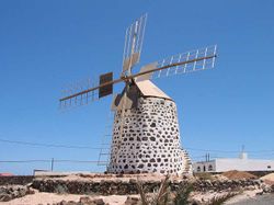
La Oliva is famous for its windmill built in stone. The roof is colored like sand. The stone lining encircles the windmill.Other
La Oliva has schools, lyceums, a few gymnasia, a few churches, beaches, a post office, parks and a squares (plaza).External links
| North: Atlantic Ocean | ||
| West: Atlantic Ocean |
La Oliva | East: Atlantic Ocean |
| South: Puerto del Rosario |