
Kötschach-Mauthen
Encyclopedia
Kötschach-Mauthen is a municipality in the district of Hermagor in Carinthia
in Austria
.
. It's just a few minutes away from Plöcken Pass
, and hence Friuli
/Italy
.
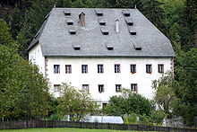
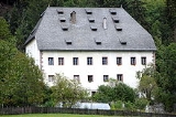
In the Middle Ages the region experienced economic growth due to the exploitation of iron ore, gold, silver and lead. Most of today's towns were already mentioned in the Middle Ages: Mauthen 1276, Höfling 1300, Kötschach 1308, Podlanig 1374, Würmlach 1374 and St. Jakob 1376. In the 16th century followed Laas 1510, Mandorf 1521, and Gentschach 1590.
Since the 16th century the region belonged to the Count of Ortenburg. On the occasion of the 10th anniversary of the Carinthian Plebiscite the town became a Market Municipality in 1930.
In 1958 Kötschach and Mauthen were merged and became the municipality of Kötschach-Mauthen. A few years later, in 1973, extensive areas in the upper Gailtal and in the lower Lesachtal were added to the municipality.
. 1,8 % of the population are without any religious confession.
. Wood processing, the production of heat exchangers, tourism in general and gastronomy in particular are important economic factors of the region. Kötschach-Mauthen is well-known as a wellness and climatic spa. The town boasts a modern outdoor and indoor swimming pool ("Aquarena"), which is the biggest in both Upper Gailtal and Lesachtal.
The National Hospital in nearby Laas consists of a medical department as well as a department for chronic patients.
In Würmlach the pipelines AWP
, which goes to Schwechat near Vienna, and TAL, which leads to Karlsruhe in Germany, split up. Since 2005 gas is being pumped from Würmlach's biological gas facility to Kötschach into its combined heat and power station.
Carinthia (state)
Carinthia is the southernmost Austrian state or Land. Situated within the Eastern Alps it is chiefly noted for its mountains and lakes.The main language is German. Its regional dialects belong to the Southern Austro-Bavarian group...
in Austria
Austria
Austria , officially the Republic of Austria , is a landlocked country of roughly 8.4 million people in Central Europe. It is bordered by the Czech Republic and Germany to the north, Slovakia and Hungary to the east, Slovenia and Italy to the south, and Switzerland and Liechtenstein to the...
.
Geography
The municipality lies 34 km in the west of Hermagor at the transition of the upper Gailtal into LesachtalLesachtal
The Lesachtal is a valley in the Austrian state of Carinthia. It is the uppermost part of the valley formed by the Gail River, and stretches from the border between East Tyrol and Carinthia to Kötschach-Mauthen ....
. It's just a few minutes away from Plöcken Pass
Plöcken Pass
Plöcken Pass is a high mountain pass in the Carnic Alps mountain range at the border between the Austrian state of Carinthia and the Friuli-Venezia Giulia region of Italy. It links the market town of Kötschach-Mauthen in the Gail Valley with Tolmezzo on the Tagliamento River.-See also:* List of...
, and hence Friuli
Friuli
Friuli is an area of northeastern Italy with its own particular cultural and historical identity. It comprises the major part of the autonomous region Friuli-Venezia Giulia, i.e. the province of Udine, Pordenone, Gorizia, excluding Trieste...
/Italy
Italy
Italy , officially the Italian Republic languages]] under the European Charter for Regional or Minority Languages. In each of these, Italy's official name is as follows:;;;;;;;;), is a unitary parliamentary republic in South-Central Europe. To the north it borders France, Switzerland, Austria and...
.
Municipality arrangement
Kötschach-Mauthen is divided into the four municipalities Kötschach, Mauthen, Strajach and Würmlach. It covers 31 localities (in parentheses number of inhabitants according to the 2001 population census):
|
|
|
|
History
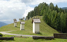
Today's municipality was established around 200 BC. A Venetian rock inscription from this time still exists today in Würmlach. A Roman road ran over the Plöckenpass, where a Roman settlement was situated above present-day Mauthen .In the Middle Ages the region experienced economic growth due to the exploitation of iron ore, gold, silver and lead. Most of today's towns were already mentioned in the Middle Ages: Mauthen 1276, Höfling 1300, Kötschach 1308, Podlanig 1374, Würmlach 1374 and St. Jakob 1376. In the 16th century followed Laas 1510, Mandorf 1521, and Gentschach 1590.
Since the 16th century the region belonged to the Count of Ortenburg. On the occasion of the 10th anniversary of the Carinthian Plebiscite the town became a Market Municipality in 1930.
In 1958 Kötschach and Mauthen were merged and became the municipality of Kötschach-Mauthen. A few years later, in 1973, extensive areas in the upper Gailtal and in the lower Lesachtal were added to the municipality.
Population
According to the 2001 population census Kötschach-Mauthen has 3.613 inhabitants. 95,0 % of its inhabitants are Austrian, 1,2 % German and 0,9 % Turkish citizens. 89,1 % of the population are Roman-Catholic, 6,6 % Protestant and 1,3 % are MuslimIslam
Islam . The most common are and . : Arabic pronunciation varies regionally. The first vowel ranges from ~~. The second vowel ranges from ~~~...
. 1,8 % of the population are without any religious confession.
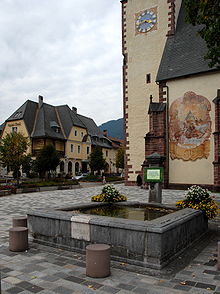
Gailtaler Dom
The parish church "Unsere liebe Frau" (better known as "Gailtaler Dom") in Kötschach is a Late Gothic church and was built by Bartholomäus Viertaler. Mentioned for the first time in 1399, it was rebuilt extensively in the first half of the 16th century (1518-27).Economy and infrastructure
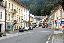
Kötschach-Mauthen is a central municipality in the upper Gailtal and at the same time a gate to the LesachtalLesachtal
The Lesachtal is a valley in the Austrian state of Carinthia. It is the uppermost part of the valley formed by the Gail River, and stretches from the border between East Tyrol and Carinthia to Kötschach-Mauthen ....
. Wood processing, the production of heat exchangers, tourism in general and gastronomy in particular are important economic factors of the region. Kötschach-Mauthen is well-known as a wellness and climatic spa. The town boasts a modern outdoor and indoor swimming pool ("Aquarena"), which is the biggest in both Upper Gailtal and Lesachtal.
The National Hospital in nearby Laas consists of a medical department as well as a department for chronic patients.
In Würmlach the pipelines AWP
Adria–Wien Pipeline
The Adria–Wien Pipeline is a crude oil pipeline, which connects the Transalpine Pipeline from Würmlach at the Italian-Austrian border with the Schwechat Refinery near Vienna, Austria. It allows oil supplies to Austria from the Italian oil terminal in Trieste.-History:The planning of the pipeline...
, which goes to Schwechat near Vienna, and TAL, which leads to Karlsruhe in Germany, split up. Since 2005 gas is being pumped from Würmlach's biological gas facility to Kötschach into its combined heat and power station.
Politics
Since the 2003 elections the local council consists of- SPÖ (12 mandates)
- ÖVP (6)
- FPÖ (3)
- List Thurner (2)