

Krimmler Wasserfälle
Encyclopedia
Waterfall
A waterfall is a place where flowing water rapidly drops in elevation as it flows over a steep region or a cliff.-Formation:Waterfalls are commonly formed when a river is young. At these times the channel is often narrow and deep. When the river courses over resistant bedrock, erosion happens...
in Austria
Austria
Austria , officially the Republic of Austria , is a landlocked country of roughly 8.4 million people in Central Europe. It is bordered by the Czech Republic and Germany to the north, Slovakia and Hungary to the east, Slovenia and Italy to the south, and Switzerland and Liechtenstein to the...
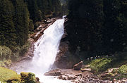
. The falls are formed from the Krimmler Ache river and are located near the village of Krimml in the High Tauern National Park
National park
A national park is a reserve of natural, semi-natural, or developed land that a sovereign state declares or owns. Although individual nations designate their own national parks differently A national park is a reserve of natural, semi-natural, or developed land that a sovereign state declares or...
in Salzburgerland.
Falls
Waterfall
A waterfall is a place where flowing water rapidly drops in elevation as it flows over a steep region or a cliff.-Formation:Waterfalls are commonly formed when a river is young. At these times the channel is often narrow and deep. When the river courses over resistant bedrock, erosion happens...
. The waterfall begins at the Krimmler Ache at the top of the Krimmler Achendal, and plunges downward in three stages. The upper stage has a drop of 140 metres, the middle of 100 metres, and the lowest a drop of 140 metres.
Flow
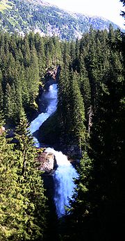
The Krimmler Ache is a glacial stream whose flow varies greatly with season. The flow in June and July is 20,000 m³/h (about 5.28 million gallons per hour), while in February it is only 500 m³/h (about 0.13 million gallons per hour). The greatest measured flow was on 25 August 1987, when it was 600,000 m³/h, or almost 160 million gallons per hour.After the falls, the river joins the Salzach
Salzach
The Salzach is a river in Austria and Germany. It is a right tributary of the Inn and is 225 kilometres in length.The river's name is derived from the German word Salz, meaning "salt". Until the 19th century shipping of salt down the river was an important part of the local economy...
, which flows to the Inn, then into the Danube River and finally to the Black Sea
Black Sea
The Black Sea is bounded by Europe, Anatolia and the Caucasus and is ultimately connected to the Atlantic Ocean via the Mediterranean and the Aegean seas and various straits. The Bosphorus strait connects it to the Sea of Marmara, and the strait of the Dardanelles connects that sea to the Aegean...
.
Tourism
To ensure that tourists could see more of the waterfall without difficulty, Ignaz von Kürsinger, from MittersillMittersill
Mittersill is a city in the federal state of Salzburg, Austria, in the Pinzgau region of the Alps. It is located on the Salzach River. It had a population of 5,464 in 2005.- Geography :...
, created a path to the upper part of the waterfall. In 1879, the Austrian Alpine Club improved the road to provide a more panoramic view. The falls are visited annually by about 400,000 people. There is a negative impact on the local residents, because of the high traffic level in a small village, and because of erosion to the road.
Information
- Slupetzky, Heinz and Johannes Wiesenegger. 1993. Vom Schnee, Eis, Schmelzwasser und Regen zum Gletscherbach – Hydrologie der Krimmler Ache In: Krimmler Wasserfälle, Festschrift 25 Jahre Europäisches Naturschutzdiplom 1967-1992, Innsbruck Austria. ["From snow, ice, melt-water and rain to glacial stream - Hydrology of the Krimmler Ache"]
- Stocker, Erich. 1993. Zur Geomorphologie der Krimmler Wasserfälle In: Krimmler Wasserfälle, Festschrift 25 Jahre Europäisches Naturschutzdiplom 1967-1992, Innsbruck Austria. ["On the geomorphology of the Krimmler Wasserfälle"]